
Emerald Lake Hills or Emerald Hills is a census-designated place and neighborhood in unincorporated San Mateo County, in the state of California, United States. Situated among oak-studded hills between Woodside, Redwood City, and San Carlos roughly bounded by Edgewood Road, Alameda de las Pulgas, Farm Hill Boulevard, and Interstate 280. The population was 4,406 at the 2020 census and the per-capita income was $68,966, making it the 22nd wealthiest place in California and the 82nd highest income places in the United States

New England is a geographical region in the north of the state of New South Wales, Australia, about 60 km inland from the Tasman Sea. The area includes the Northern Tablelands and the North West Slopes regions. As of 2021, New England had a population of 185,560, with over a quarter of the people living in the area of Tamworth Regional Council.
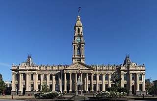
South Melbourne is an inner suburb in Melbourne, Victoria, Australia, 3 km south of Melbourne's Central Business District, located within the City of Port Phillip local government area. South Melbourne recorded a population of 11,548 at the 2021 census.

Emerald is a rural town and locality in the Central Highlands Region, Queensland, Australia. In the 2021 census, the locality of Emerald had a population of 14,906 people.

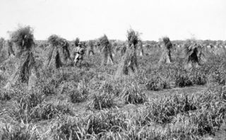
Gunnedah is a town in north-eastern New South Wales, Australia and is the seat of the Gunnedah Shire local government area. In the 2021 census the town recorded a population of 8,338. Gunnedah is situated within the Liverpool Plains, a fertile agricultural region, with 80% of the surrounding shire area devoted to farming. The Namoi River flows west then north-west through the town providing water beneficial to agricultural operations in the area.

Liverpool Plains Shire is a local government area located in the North West Slopes region of New South Wales, Australia. The Shire was formed on 17 March 2004 by the amalgamation of Quirindi Shire with parts of Parry, Murrurundi and Gunnedah shires.

The City of Hawkesbury is a local government area of New South Wales, Australia, the City of Hawkesbury is located on the North and North Western edge of the Greater Sydney area and is adjacent to the Sydney metropolitan area, about 50 kilometres (31 mi) north-west of the Sydney central business district. Hawkesbury City is named after the Hawkesbury River.

Anakie Siding is a rural locality in the Central Highlands Region, Queensland, Australia. The town of Anakie is within the locality. It is a sapphire mining area. In 2021 census, the locality of Anakie Siding had a population of 155 people.
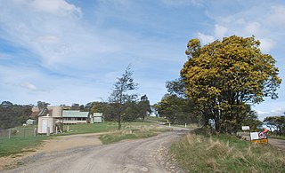
Matlock is a rural locality in Victoria, Australia, located about 140 kilometres north-east of Melbourne, located within the Shires of Mansfield and Yarra Ranges local government areas. Matlock recorded a population of 7 at the 2021 census.

Regents Park is a suburb in the City of Logan, Queensland, Australia. In the 2016 census Regents Park had a population of 10,962 people.

The City of Coffs Harbour is a local government area in the mid north coast region of New South Wales, Australia. The area under administration is 1,175 square kilometres (454 sq mi), expanded in 2004 to take in parts of the former Pristine Waters local government area.

Gunnedah Shire is a local government area in the North West Slopes region of New South Wales, Australia. The Shire is located adjacent to the Liverpool Plains in the Namoi River valley and is traversed by the Oxley Highway and the Kamilaroi Highway.
Breeza is a locality in New South Wales, Australia. It is about 43 kilometres (27 mi) south of Gunnedah, in the Liverpool Plains agricultural region. The area around Breeza in particular is called the "Breeza Plains". The name "Breeza" may be derived from an Aboriginal word meaning "one hill".

Carroll is a parish and small village on the Oxley Highway, 20 km east of Gunnedah, New South Wales. At the 2016 census, Carroll had a population of 337 people. The Namoi River runs approximately parallel to the highway which is also the main street there. Periodically this river floods the town and surrounding area, forcing the closure of the Oxley Highway. The surrounding area is part of the Liverpool Plains region.

Mullaley is a village in the Gunnedah Shire, New South Wales, Australia.
Somerton is a village between Tamworth and Gunnedah on the Oxley Highway in northern New South Wales Australia. In the 2016 census, there were 277 people in Somerton. Somerton Village adjoins the plentiful Peel River.

Curlewis is a parish and a rural village on the Kamilaroi Highway, 16 kilometres south of Gunnedah, New South Wales in Australia. The village boundaries are in the Gunnedah Shire local government area of the North West Slopes portion of the New England region.
Gindie is a rural locality in the Central Highlands Region, Queensland, Australia. In the 2021 census, Gindie had a population of 232 people.
Lochington is a rural locality in the Central Highlands Region, Queensland, Australia. At the 2021 census, Lochington had a population of 128 people.
Gordonstone is a rural locality in the Central Highlands Region, Queensland, Australia. At the 2021 census, Gordonstone had a population of 32 people.
