| Little Murray River | |
|---|---|
| Location | |
| Country | Australia |
| State | New South Wales, Victoria |
| Region | Riverina (IBRA) |
| Municipalities | Wakool, Balranald |
| Physical characteristics | |
| Source | Murray River |
| • location | near Barham |
| Mouth | confluence with the Murray River |
• location | Gonn Crossing, Victoria |
• elevation | 75 m (246 ft) |
| Length | 22 km (14 mi) |
| Basin features | |
| River system | Murray River, Murray–Darling basin |
| Island | Campbells Island |
| [1] | |
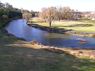
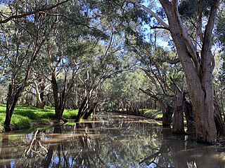
Little Murray River (New South Wales), an anabranch [1] of the Murray River and part of the Murray-Darling basin, is located in the western Riverina region of south western New South Wales, Australia.
The river rises northwest of Barham in New South Wales and flows generally northwest before reaching its confluence with the Murray River near Gonn Crossing in Victoria. Little Murray River and the Murray River enclose Campbells Island, that forms part of the Campbells Island State Forest.

The Culgoa River is a river that is part of the Darling catchment within the Murray–Darling basin and is located in South West Queensland.

The Macquarie River is part of the Macquarie–Barwon catchment within the Murray–Darling basin, is one of the main inland rivers in New South Wales, Australia.
The Macintyre River, a perennial river that forms part of the Border Rivers group, is part of the Barwon catchment of the Murray-Darling basin, located in the Northern Tablelands and North West Slopes regions of New South Wales, and the Southern Downs region of Queensland, Australia.
The Murray Irrigation Area is geographically located within the Riverina area of New South Wales, between Mulwala and Moulamein. It was created to control and divert the flow of local river and creek systems for the purpose of food production. The main river system feeding and fed by the area is the Murray River.
Tooma River, a perennial stream that has had some of its flow diverted as a result of the Snowy Mountains Scheme, is part of the Murray catchment within the Murray–Darling basin and is located in the Australian Alpine region of New South Wales, Australia.

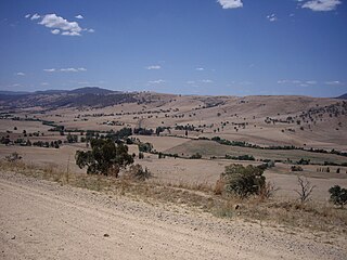
The geography of Australia encompasses a wide variety of biogeographic regions being the world's smallest continent, while comprising the territory of the sixth-largest country in the world. The population of Australia is concentrated along the eastern and south-eastern coasts. The geography of the continent is extremely diverse, ranging from the snow-capped mountains of the Australian Alps and Tasmania to large deserts, tropical and temperate forests, grasslands, heathlands and woodlands.
The Boomi River, an anabranch of the Barwon River and part of the Macintyre catchment within the Murray–Darling basin, is located in the north–western slopes region of New South Wales, flowing downstream into the South Downs region of Queensland, Australia.
Campbells River, a perennial stream that is part of the Upper Macquarie catchment within the Murray–Darling basin, is located in the central–western region of New South Wales, Australia.
The Crookwell River is a perennial river that is part of the Lachlan catchment within the Murray–Darling basin, located in the Southern Tablelands and South West Slopes regions of New South Wales, Australia.
Endrick River is a perennial river of the Shoalhaven catchment located in the Southern Tablelands region of New South Wales, Australia.

Goobarragandra River, a perennial stream that is part of the Murrumbidgee catchment within the Murray–Darling basin, is located in the Snowy Mountains region of New South Wales, Australia. In the past, it was also known as Tumut Little River.
Bluff River, a mostly perennial stream of the Dumaresq–Macintyre catchment within the Murray–Darling basin, is located in the Northern Tablelands district of New South Wales, Australia.
Isabella River, a perennial stream that is part of the Lachlan catchment within the Murray–Darling basin, is located in the central–western region of New South Wales, Australia.
The Burke River, a watercourse that is part of the Nepean River catchment, is located in the Southern Highlands of New South Wales, Australia.
Tumbarumba Creek, a watercourse of the Murray catchment within the Murray–Darling basin, is located in the region bordering the Riverina and Australian Alps of New South Wales, Australia.
The New South Wales Central Murray Forests lie on the floodplain of the Murray River in the Riverina region of south-central New South Wales, Australia. On 20 May 2003 the forests were recognised as a wetland site of international importance (RS1291) by designation under the Ramsar Convention on Wetlands.
The Jugiong Creek, a mostly–perennial river that is part of the Murrumbidgee catchment within the Murray–Darling basin, is located in the South West Slopes region of New South Wales, Australia.
The Cooks Vale Creek, a mostly–perennial river that is part of the Lachlan sub-catchment of the Murrumbidgee catchment within the Murray–Darling basin, is located in the South West Slopes region of New South Wales, Australia.
The Bulla Creek, a mostly–perennial river that is part of the Lachlan sub-catchment of the Murrumbidgee catchment within the Murray–Darling basin, is located in the South West Slopes region of New South Wales, Australia. The Bulla Creek is only connected to the Murray Darling basin when the Bland Creek and both the Lachlan and Murrumbidgee Rivers are in flood.
Mirrool Creek, a watercourse that is part of the Lachlan sub-catchment of the Murrumbidgee catchment in the Murray–Darling basin, is in the Riverina region of New South Wales, Australia. The course of the Mirrool Creek is indefinite at various locations.
Coordinates: 35°31′S144°00′E / 35.517°S 144.000°E