Twofold Bay

Last updated

Twofold Bay
Twofold Bay 001.jpg
Looking from Eden across Twofold Bay to wood chip supplies.
Australia New South Wales relief location map.png
Red pog.svg
Twofold Bay
Location of Twofold Bay in New South Wales
Location South Coast, New South Wales
Coordinates 37°03′55″S149°54′04″E / 37.06528°S 149.90111°E / -37.06528; 149.90111 [1]
Type An open oceanic embayment [2]
Primary inflows Towamba River, Nullica River
Primary outflows Tasman Sea, South Pacific Ocean
Catchment area 11 km2 (4.2 sq mi)
Basin  countriesAustralia
Surface area30.7 km2 (11.9 sq mi)
Average depth10.9 m (36 ft)
Water volume334,559 megalitres (11,814.8×10^6 cu ft)
Frozennever
Settlements Eden
Website NSW Environment & Heritage

Twofold Bay is an open oceanic embayment [2] that is located in the South Coast region of New South Wales, Australia.

Contents

The bay was named by George Bass, for its shape of two bights. [3] The northern bight is called Calle Calle Bay; [4] while the southern bight is known as Nullica Bay, derived from Nalluccer, the original Aboriginal name for Twofold Bay. [5]

The bay is also known for the "Killers of Eden", the killer whales that helped a group of whalers in their search for other whales. The best-known of these was Old Tom, whose skeleton is preserved in Eden's local museum. [6]

Location and features

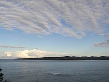
Located near the town of Eden, Twofold Bay is approximately 40 kilometres (25 mi) to the north of the border between Victoria and New South Wales. The bay is fed from the Nullica River and Towamba River that both flow into Nullica Bay.

The catchment area of the bay is 11 square kilometres (4.2 sq mi) with a volume of 334,559 megalitres (11,814.8×10^6 cu ft) over a surface area of 30.7 square kilometres (11.9 sq mi), at an average depth of 10.9 metres (36 ft); [7] making the bay reputedly the third deepest natural harbour in the Southern Hemisphere. [8]

Close to North Head is a conspicuous islet, Mewstone Rock. About 5 kilometres (3.1 mi) south of the islet is Red Point which forms the southern headland of the bay. [4] Eden and the Port of Eden are located in the bay. The historical town of Boydtown is located to the west of the bay, located on Boydtown Beach which stretches south from the mouth of the Nullica River. [9]

Local waters including Twofold Bay are recognised as one of twelve coastal aggregation areas for southern right whales in Australia. [10]

History

A view of the bay from Eden. Twofold Bay 002.jpg
A view of the bay from Eden.

Indigenous history

The original inhabitants of the area surrounding Twofold Bay were Aborigines of the Thaua or Nalbker [5] clan of the Yuin nation. [11]

European history

The first recorded visit to the bay by a European was by George Bass. The diaries of Bass show that he noted the bay when he passed it on his whaleboat voyage to Bass Strait in 1797/8. Bass took shelter in the bay on the return journey in February 1798; and named the place where he sheltered "Snug Cove", [6] a name by which the bay is still known.

On 7 October 1798 Bass and Matthew Flinders set out from Port Jackson in the Norfolk on a voyage to determine whether or not Van Diemen's Land (now called Tasmania) was attached to the mainland of Australia. Accompanying them on this voyage was the Nautilus. Two days later a survey of Twofold Bay was commenced. This very accurate survey has required little subsequent modification apart from the addition of water depths and of shore-to-shore distances between important landmarks. [6] Bass and Flinders also made their first contact with the local Thaua people.[ citation needed ]

The bay is mentioned in the logs of many ships which sheltered in it from the storms battering that part of the New South Wales coastline. Some of these ships were shipwrecked in the bay including the George (1805) and the Mary (1821). [12]

Quarantine Bay, located 3 kilometres (1.9 mi) south of Eden, is so named because a sailing ship with a smallpox epidemic amongst the people on board took refuge in this (then) isolated area. Many people died and were buried on shore in a communal grave.[ citation needed ]

In 1843 Benjamin Boyd purchased land in Twofold Bay with the aim of transporting cattle from the district. [11] Soon afterwards, Boyd started to build the Seahorse Inn adjacent to what is now called Boydtown Beach. Boydtown Beach lies on the western shore of Twofold Bay just south of the entrance to the Nullica River, which is located at the southern end of Quarantine Bay. The Seahorse Inn is still used for tourist accommodation. Nearby are the ruins of the church which Ben Boyd had constructed. Boyd conducted pastoral, whaling and shipping activities at Boydtown.

Sir Oswald Brierly, Whalers off Twofold Bay, New South Wales (1867) (Art Gallery of New South Wales) Oswald Brierly - Whalers off Twofold Bay, New South Wales, 1867.jpg
Sir Oswald Brierly, Whalers off Twofold Bay, New South Wales (1867) (Art Gallery of New South Wales)

Artist Oswald Brierly managed a bay whaling operation at Boyd Town in the 1840s and while there he did a number of paintings and sketches of the bay. [13] He did a few more paintings of the area after his return to Britain.

Evening: A scene in Boyd Town, Twofold Bay, is the title of a poem by Thomas Fennell, RN, that appeared in a New South Wales literary journal in 1847. [14] Twofold Bay is the name, and subject, of a poem by E.J. Brady. [15] Ben Boyd’s Tower, is the title of a poem by Henry Lawson. [16]

Will Lawson's book In Ben Boyd's day (1939) is set in the bay. So too is Shirley Barrett's novel Rush Oh! (2015) which offers a fictionalised account of the family of whaler George Davidson at Eden.

The history of whaling in the bay, and the role Killer Whales in that process, is the focus of the Eden Killer Whale Museum.

The Twofold Bay is mentioned in “The Children Of Captain Grant” by Jules Verne.

Industry

In the mid-2000s two major wharves dominate the south-eastern section of the bay.

The most easterly wharf services the woodchip mill. [4] Usually two ships per month use the wharf. The forestry industry plays a significant role in the region. The Eden woodchip mill is owned by South East Fibre Exports (SEFE), a subsidiary of Japan's biggest paper manufacturer, Nippon Paper Industries. The mill processes whole tree logs and is unable to process waste wood. The Eden chipmill was Australia's first chipmill and has been vigorously opposed by conservationists for over forty years. Some conservationists argue that woodchipping not only kills millions of native animals and birds, it is a major contributor to climate change.[ citation needed ]

The second wharf belongs to the Department of Defence and is used by the Royal Australian Navy to service its ships. [4] Parallel to the woodchip mill is a naval munitions storage depot. It is a multi-purpose wharf which allows other vessels, including cruise ships, to also moor at the wharf when the Naval ships are not using it. [4]

Mussel farming occupies the westerly part of the bay off the small peninsula between Cattle Bay and Quarantine Bay. [4]

See also

Related Research Articles

<span class="mw-page-title-main">Beowa National Park</span> Protected area in New South Wales, Australia

Beowa National Park, formerly Ben Boyd National Park, is a national park in New South Wales, Australia, 578 km (359 mi) south of Sydney. It was established in 1971 and officially renamed in 2022 owing to its previous namesake's connection with blackbirding. Beowa means "orca", an animal of significance to the traditional owners, the Thaua people.

<span class="mw-page-title-main">Jervis Bay</span> Oceanic bay in Jervis Bay Territory , New South Wales

Jervis Bay is a 102-square-kilometre (39 sq mi) Oceanic bay and village in the Jervis Bay Territory (ACT) and on the South Coast of New South Wales, Australia.

<span class="mw-page-title-main">Shoalhaven River</span> River in Australia

The Shoalhaven River is a perennial river that rises from the Southern Tablelands and flows into an open mature wave dominated barrier estuary near Nowra on the South Coast of New South Wales, Australia.

<span class="mw-page-title-main">Bega Valley Shire</span> Local government area in New South Wales, Australia

The Bega Valley Shire is a local government area located adjacent to the south-eastern coastline of New South Wales, Australia. The Shire was formed in 1981 with the amalgamation of the Municipality of Bega, Imlay Shire and Mumbulla Shire, with its name deriving from the town of Bega. The shire is also known as the Sapphire Coast for tourism and marketing purposes. During the 2019–20 Australian bushfire season, the area was devastated by fire, with 448 houses being destroyed by fire and approximately 365,000 hectares burned, which is 58% of the Shire's total land mass.

<span class="mw-page-title-main">Eden, New South Wales</span> Town in New South Wales, Australia

Eden is a coastal town in the South Coast region of New South Wales, Australia. The town is 478 kilometres (297 mi) south of the state capital Sydney and is the most southerly town in New South Wales, located between Nullica Bay to the south and Calle Calle Bay, the northern reach of Twofold Bay, and built on undulating land adjacent to the third-deepest natural harbour in the southern hemisphere, and Snug Cove on its western boundary. At the 2016 census, Eden had a population of 3,151.

<span class="mw-page-title-main">Benjamin Boyd</span> Scottish-Australian entrepreneur and pioneer

Benjamin Boyd was a Scottish entrepreneur who became a major shipowner, banker, grazier, politician and blackbirder in the British colony of New South Wales. He was briefly a member of the Legislative Council.

<span class="mw-page-title-main">Towamba, New South Wales</span> Town in New South Wales, Australia

Towamba is a small community, in New South Wales, Australia in Bega Valley Shire. It is located about forty minutes drive west of Eden. At the 2016 census, Towamba had a population of 234 people.

Thomas Francis Mead was an Australian politician, elected as a member of the New South Wales Legislative Assembly representing the seat of Hurstville for the Liberal Party. He was also a political journalist.

<span class="mw-page-title-main">Old Tom (orca)</span> Killer whale known to Australian whalers

Old Tom was a killer whale (orca) known to whalers in the port of Eden, New South Wales, on the southeast coast of Australia. Old Tom measured 22 feet (6.7 m) and weighed 6 tons, with a 3.33 ft (1.01 m) skull and teeth about 5.31 inches (135 mm) long.

<span class="mw-page-title-main">Whaling in Australia</span> Industry

Whaling in Australian waters began in 1791 when five of the 11 ships in the Third Fleet landed their passengers and freight at Sydney Cove and then left Port Jackson to engage in whaling and seal hunting off the coast of Australia and New Zealand. The two main species hunted by such vessels in the early years were right and sperm whales. Humpback, bowhead and other whale species would later be taken.

<span class="mw-page-title-main">Green Cape Lighthouse</span> Lighthouse in New South Wales, Australia

The Green Cape Lighthouse is a heritage-listed lighthouse located at the tip of Green Cape, a headland forming the northern boundary of Disaster Bay, in southern New South Wales, Australia. It is the southernmost lighthouse in New South Wales and Australia's first lighthouse built in concrete. At 29 metres (95 ft) it is also the tallest lighthouse in New South Wales. It marks Green Cape on the northerly shore-hugging sailing course.

<span class="mw-page-title-main">Boydtown, New South Wales</span> Town in New South Wales, Australia

Boydtown is a village on Twofold Bay near Eden, on the far south coast of New South Wales, Australia. It was the original settlement in the bay, founded by Benjamin Boyd in 1843 to service his properties on the Monaro plains. The remains of whaling stations and the local landmark Boyd's Tower, a stone spotting tower used to look for whales, are all nearby.

<span class="mw-page-title-main">Port of Eden</span> Port in Australia

The Port of Eden is a small seaport situated in Twofold Bay, adjacent to the town of Eden, located in the South Coast region of New South Wales, Australia.

<span class="mw-page-title-main">Thaua</span> Aboriginal Australian people of the south coast of New South Wales

The Thaua people, also spelt Thawa and Dhawa, and also referred to as Yuin (Djuin), are an Aboriginal Australian people living around the Twofold Bay area of the South Coast of New South Wales.

The Nullica River is an intermittently closed semi-mature saline coastal lagoon or perennial river, located in the South Coast region of New South Wales, Australia.

The Towamba River is an open mature wave dominated barrier estuary or perennial river, located in the South Coast region of New South Wales, Australia.

<span class="mw-page-title-main">Killer whales of Eden, New South Wales</span> Group of killer whales in Australia

The killers of Eden or Twofold Bay killers were a group of killer whales known for their co-operation with human hunters of cetacean species. They were seen near the port of Eden in southeastern Australia between 1840 and 1930. A pod of killer whales, which included amongst its members a distinctive male called Old Tom, would assist whalers in hunting baleen whales. The killer whales would find target whales, shepherd them into Twofold Bay or neighbouring regions of coast, and then often swim many kilometres away from the location of the hunt to alert the whalers at their cottage to their presence and often help to kill the whales.

Samuel Enderby & Sons was a whaling and sealing company based in London, England, founded circa 1775 by Samuel Enderby (1717–1797). The company was significant in the history of whaling in the United Kingdom, not least for encouraging their captains to combine exploration with their business activities, and sponsored several of the earliest expeditions to the subantarctic, Southern Ocean and Antarctica itself.

<span class="mw-page-title-main">Davidson Whaling Station</span> Historic site in New South Wales, Australia

Davidson Whaling Station is a heritage-listed former whaling station at Edrom, Bega Valley Shire, New South Wales, Australia. It was built in 1896. The property is owned by the New South Wales Office of Environment and Heritage. It was added to the New South Wales State Heritage Register on 2 April 1999.

The Bundian Way is a heritage-listed former 265-kilometre (165 mi) Aboriginal travelling route for cultural use, maritime trade, education, and exploration. The route now forms part of the Kosciuszko National Park, state forest, and local roads from Mount Kosciuszko through Snowy Monaro Regional Council to Eden in New South Wales, Australia. It is also known as Aboriginal track path. It was added to the New South Wales State Heritage Register on 18 January 2013.

References

  1. "Twofold Bay (NSW)". Gazetteer of Australia online. Geoscience Australia, Australian Government.
  2. 1 2 Roy, P. S; Williams, R. J; Jones, A. R; Yassini, I; et al. (2001). "Structure and Function of South-east Australian Estuaries". Estuarine, Coastal and Shelf Science . 53 (3): 351–384. Bibcode:2001ECSS...53..351R. doi:10.1006/ecss.2001.0796.
  3. Estensen, Miriam (2005). The Life of George Bass . Allen and Unwin. p.  82. ISBN   1-74114-130-3.
  4. 1 2 3 4 5 6 "Eden: a natural paradise" (PDF). Tourism Guide. visiteden.com.au. Retrieved 1 June 2013.
  5. 1 2 Robinson, George Augustus; Clark, Ian D (2014). Travels of George Augustus Robinson, Chief Protector, Port Phillip Aboriginal Protectorate.
  6. 1 2 3 Wellings, H. P. (1996). Eden and Twofold Bay: Discovery, Early History and Points of Interest 1797-1965 (Second ed.). ISBN   0-646-29410-5.
  7. "Twofold Bay". Coastal and floodplain management: Coastal zone management: Estuaries of NSW. NSW Environment and Heritage. 27 April 2012. Retrieved 1 June 2013.
  8. "Welcome to Eden: homepage". Visit Eden. Eden Chamber of Commerce. 2013. Retrieved 1 June 2013.
  9. "Twofold Bay". Geographical Names Register (GNR) of NSW. Geographical Names Board of New South Wales . Retrieved 1 June 2013. OOjs UI icon edit-ltr-progressive.svg
  10. "Conservation Management Plan for the Southern Right Whale - A Recovery Plan under the Environment Protection and Biodiversity Conservation Act 1999 (2011–2021)" (PDF). Archived (PDF) from the original on 2 April 2015. Retrieved 8 December 2015.{{cite journal}}: Cite journal requires |journal= (help)
  11. 1 2 Blaxell, Gregory (1 September 2008). "Twofold Bay and Eden". Afloat. Afloat Publications. p. 28.
  12. Bateson, Charles (1982) Australian shipwrecks: Volume One; 1622-1850, Sydney, Reed, pp. 41–2 & 61. ISBN   0589071122
  13. Diamond, Marion (1988) The Seahorse and the Wanderer: Ben Boyd in Australia, Melbourne University Press, p. 99. ISBN   0522843557
  14. “Evening ...", Heads of the People: an illustrated journal of literature, whims and oddities, 1 (21) September 4, 1847, p. 149
  15. Brady, E.J. (1933) Wardens of the sea, Sydney, Endeavour Press, pp. 22–24
  16. Kieza, Grantlee (2021). Lawson (First ed.). Sydney: ABC Books. p. 390. ISBN   9780733340529.