The Blue Mountains are a mountainous region and a mountain range located in New South Wales, Australia. The region is considered to be part of the western outskirts of the Greater Sydney area. The region borders on Sydney's main metropolitan area, its foothills starting about 50 kilometres (31 mi) west of centre of the state capital, close to Penrith. The public's understanding of the extent of the Blue Mountains is varied, as it forms only part of an extensive mountainous area associated with the Great Dividing Range. As defined in 1970, the Blue Mountains region is bounded by the Nepean and Hawkesbury rivers in the east, the Coxs River and Lake Burragorang to the west and south, and the Wolgan and Colo rivers to the north. Geologically, it is situated in the central parts of the Sydney Basin.

Heathcote National Park is a protected national park that is located in the southern area of Sydney, New South Wales in eastern Australia, and is situated on Dharawal country. The 2,679-hectare (6,620-acre) national park is situated approximately 35 kilometres (22 mi) southwest of the Sydney central business district, west of the Illawarra railway line, the Princes Highway and Motorway, and the suburbs of Heathcote and Waterfall.
The Wollemi National Park is a protected national park and wilderness area that is located in the Central West and Hunter region of New South Wales, in eastern Australia. The 501,703-hectare (1,239,740-acre) park, the second largest national park in New South Wales, contains the 361,113-hectare (892,330-acre) Wollemi Wilderness – the largest such wilderness area in Australia – and is situated approximately 130 kilometres (81 mi) northwest of Sydney.

The Wingecarribee River, a perennial river that is part of the Hawkesbury–Nepean catchment, is located in the Southern Highlands region of New South Wales, Australia.

The Hawkesbury River, or Hawkesbury-Nepean River a river located northwest of Sydney, New South Wales, Australia. The Hawkesbury River and its associated main tributary, the Nepean River, almost encircle the metropolitan region of Sydney. The river between Wisemans Ferry and the Pacific Ocean marks the boundary of Greater Metropolitan Sydney in the south and the Central Coast region to the north.

The Colo River, a perennial stream that is part of the Hawkesbury-Nepean catchment, is located in the Central Tablelands of New South Wales, Australia.

The Nepean River, is a major perennial river, located in the south-west and west of Sydney, New South Wales, Australia. The Nepean River, and, continuing by its downstream name, the Hawkesbury River, almost encircles the metropolitan region of Sydney.
The Wollemi Creek, a partly perennial stream of the Hawkesbury-Nepean catchment, is located in the Central Tablelands and Blue Mountains regions of New South Wales, Australia.

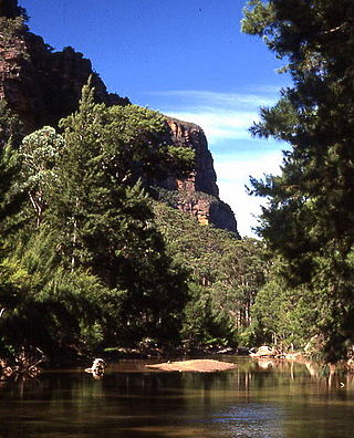
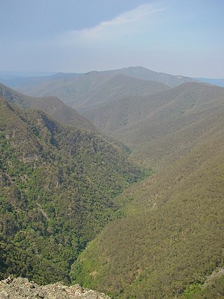
The Grose Valley is a rugged valley in the Blue Mountains, New South Wales, Australia. It has been formed by the Grose River, the headwaters of which are in the Mount Victoria area. The valley is located between the Great Western Highway and Bells Line of Road, the two major routes across the Blue Mountains. The majority of the valley falls within the Blue Mountains National Park.

The Wollondilly River, an Australian perennial river that is part of the Hawkesbury–Nepean catchment, is located in the Southern Tablelands and Southern Highlands regions of New South Wales. The river meanders from its western slopes near Crookwell, flowing south-east through Goulburn, turning north-east to near Bullio, flowing north-west to Barrallier, before finally heading north-easterly into its mouth at Lake Burragorang.
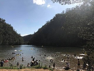
Bents Basin is a protected nature reserve and state park near Wallacia, New South Wales, Australia in the Sydney metropolitan area. The lake basin, which formed at the efflux of the Nepean River from the Hawkesbury Sandstone gorge, is a popular swimming hole with a camping area and an education centre used by local school groups. Also featuring a large woodland area and native wildlife, the reserve is the only picnic area along the Nepean River and it is one of the most popular water-based picnic parks in Greater Western Sydney.

Pittwater is a semi-mature tide dominated drowned valley estuary, located about 40 kilometres (25 mi) north of the Sydney central business district, New South Wales, Australia; being one of the bodies of water that separate greater Metropolitan Sydney from the Central Coast.
The Coxs River, a perennial river that is part of the Hawkesbury-Nepean catchment, is located in the Central Tablelands, Blue Mountains, and Macarthur regions of New South Wales, Australia.
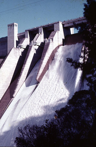
The Warragamba River, a river that is part of the Hawkesbury-Nepean catchment, is located in the Macarthur region of New South Wales, Australia.
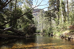
The Kowmung River, a perennial river that is part of the Hawkesbury-Nepean catchment, is located in the Central Tablelands region of New South Wales, Australia.
The Tonalli River, a perennial river that is part of the Hawkesbury-Nepean catchment, is located in the Blue Mountains region of New South Wales, Australia.

The Wollangambe River, an Australian perennial river that is part of the Hawkesbury–Nepean catchment within the Sydney Basin, is located in the Greater Blue Mountains Area of New South Wales.
The Little River, a perennial river that is part of the Hawkesbury-Nepean catchment, is located in the Southern Highlands region of New South Wales, Australia.
The Little River, a perennial river that is part of the Hawkesbury-Nepean catchment, is located in the Central Tablelands region of New South Wales, Australia.
The Kanangra Creek, a perennial stream of the Hawkesbury-Nepean catchment, is located in the Blue Mountains region of New South Wales, Australia.