Hazelbrook, New South Wales

Last updated

Hazelbrook
City of Blue Mountains,  New South Wales
Australia New South Wales location map blank.svg
Red pog.svg
Hazelbrook
Hazelbrook, New South Wales
Coordinates 33°44′S150°27′E / 33.733°S 150.450°E / -33.733; 150.450
Population5,077 (2021 census) [1]
Postcode(s) 2779
Elevation675 m (2,215 ft)
Location
LGA(s) City of Blue Mountains
State electorate(s) Blue Mountains
Federal division(s) Macquarie
Suburbs around Hazelbrook:
Blue Mountains National Park Blue Mountains National Park
Lawson Hazelbrook Woodford

Hazelbrook is a town in New South Wales, Australia (Elevation: 675 metres [2] ) It is located 91 kilometres west of Sydney and 16 kilometres east of Katoomba in the Blue Mountains on the Great Western Highway.

Contents

History and description

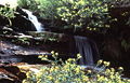
The town was named after Hazelbrook House, built in the 1870s by Svonte Noles. The name Hazelbrook was adopted in 1894 when the Hazelbrook railway station was opened opposite the home. [3] Hazelbrook House no longer exists but Selwood House is a heritage-listed building in the nearby vicinity and now houses a veterinary practice. Other attractions in the area include Terrace Falls, Victor Falls and Bedford Pool on the south side of the village, plus Lyre Bird Glen, Oaklands Falls, Horseshoe Falls and Burgess Falls on the north side. [4]

1st Hazelbrook scout group was established in 1922 and was part of the lower blue mountains district and is now part of blue mountains district. 1st Hazelbrook scout group is one of 5 scouts groups in the blue mountains. On 16th October 2022 1st Hazelbrook scout group celebrated their 100th anniversary

The village is serviced by a number of schools; Hazelbrook Public School [5] (kindergarten to Year 6), the humanist Korowal [6] School (Kindergarten to HSC), Blue Mountains Steiner [7] (Pre-School to Year 6) and two child care centres.

There is a shopping centre that includes a supermarket and several shops, restaurants and cafes.

Hazelbrook volunteer Rural Fire brigade established in 1959 by the local community and is one of 26 rural fire brigade in the blue mountains. Hazelbrook rural fire brigade has 3 fire truck one category 1 fire tankers two category 7 fire tankers One PC

Hazelbrook has a local football club, known as the Hazelbrook Hawks, whose home ground is Gloria Park, [8] and a lawn bowls club, co-located at Gloria Park.

Australian author James Roy lives in Hazelbrook.

Population

According to the 2021 census of Population, there were 5,077 people in Hazelbrook.

See also

Related Research Articles

<span class="mw-page-title-main">New South Wales</span> Eastern state of Australia

New South Wales is a state on the east coast of Australia. It borders Queensland to the north, Victoria to the south, and South Australia to the west. Its coast borders the Coral and Tasman Seas to the east. The Australian Capital Territory and Jervis Bay Territory are enclaves within the state. New South Wales' state capital is Sydney, which is also Australia's most populous city. In December 2021, the population of New South Wales was over 8 million, making it Australia's most populous state. Just under two-thirds of the state's population, 5.3 million, live in the Greater Sydney area.

Glenhaven is a semi rural suburb of Sydney, in the state of New South Wales, Australia 32 kilometres west of the Sydney central business district in the local government areas of The Hills Shire and Hornsby Shire, part of the Hills District region.

<span class="mw-page-title-main">Glenbrook, New South Wales</span> Town in New South Wales, Australia

Glenbrook is a township of the Lower Blue Mountains of New South Wales, Australia. It is located 63 kilometres west of the Sydney central business district, in the local government area of the City of Blue Mountains. As of the 2021 Australian census Glenbrook had a population of 5,078 people.

<span class="mw-page-title-main">Winmalee, New South Wales</span> Town in New South Wales, Australia

Winmalee is a town in New South Wales, Australia. Winmalee is located 77 kilometres west of the Sydney CBD, in the local government area of the City of Blue Mountains. At the 2011 census, Winmalee had a population of 6,593.

<span class="mw-page-title-main">Lawson, New South Wales</span> Suburb of Blue Mountains, New South Wales, Australia

Lawson is a town in the Blue Mountains area of New South Wales, Australia. It is located on the Great Western Highway between Hazelbrook in the east and Bullaburra in the west. Lawson has a station on the Main Western line. The town is also served by a public swimming pool and over the years has developed into the commercial hub of the mid-mountains area, which spans from Linden to Bullaburra, boasting a significant industrialized area as well as a shopping centre located on the south-eastern side of the highway.

<span class="mw-page-title-main">Blaxland, New South Wales</span> Town in New South Wales, Australia

Blaxland is a town in the Blue Mountains of New South Wales, Australia. Blaxland is located 65 kilometres west of Sydney in the local government area of the City of Blue Mountains. It is at an altitude of 234 metres and borders the townships of Glenbrook, Mount Riverview and Warrimoo.

<span class="mw-page-title-main">Springwood, New South Wales</span> Town in New South Wales, Australia

Springwood is a town in the Blue Mountains, New South Wales, Australia. Springwood is located 72 kilometres west of the Sydney CBD in the local government area of the City of Blue Mountains. At the 2021 census, Springwood had a population 8,423 people.

<span class="mw-page-title-main">New South Wales Rural Fire Service</span> Volunteer firefighting agency

The New South Wales Rural Fire Service is a volunteer-based firefighting agency and statutory body of the Government of New South Wales.

<span class="mw-page-title-main">Wentworth Falls, New South Wales</span> Suburb of City of Blue Mountains, New South Wales, Australia

Wentworth Falls is a town in the Blue Mountains region of New South Wales, situated approximately 100 kilometres (62 mi) west of the Sydney central business district, and about 8 kilometres (5.0 mi) east of Katoomba, Australia on the Great Western Highway, with a Wentworth Falls railway station on the Main Western line. The town is at an elevation of 867 metres (2,844 ft) AHD . At the 2016 census, Wentworth Falls had a population of 6,076.

Regentville is a suburb of Sydney, in the state of New South Wales, Australia. It is 56 kilometres west of the Sydney central business district, in the local government area of the City of Penrith, and is part of the Greater Western Sydney region. It is located on the eastern bank of the Nepean River, just south of Jamisontown.

<span class="mw-page-title-main">Mount Riverview, New South Wales</span> Town in New South Wales, Australia

Mount Riverview is a town off the Great Western Highway about 2 km NE of Blaxland in the Lower Blue Mountains, New South Wales, 70 kilometres west of the Sydney CBD, Australia. At the 2006 census, Mount Riverview had a population of 2,993 people.

<span class="mw-page-title-main">Bullaburra, New South Wales</span> Suburb of City of Blue Mountains, New South Wales, Australia

Bullaburra is a small town in the state of New South Wales, Australia, in the City of Blue Mountains. It is one of the towns that stretch along the route of the Main Western railway line and Great Western Highway which pass over the Blue Mountains, west of Sydney. Bullaburra used to have a service station but it was demolished in 2008. Bullaburra is an Aboriginal word meaning clear day.

<span class="mw-page-title-main">Woodford railway station</span> Railway station in New South Wales, Australia

Woodford railway station is located on the Main Western line in New South Wales, Australia. It serves the Blue Mountains village of Woodford opening on 11 July 1868 as Buss' Platform, being renamed Woodford on 1 June 1871.

<span class="mw-page-title-main">Hazelbrook railway station</span> Railway station in New South Wales, Australia

Hazelbrook railway station is located on the Main Western line in New South Wales, Australia. It serves the Blue Mountains town of Hazelbrook.

<span class="mw-page-title-main">Fire and Rescue New South Wales</span> Emergency service in New South Wales, Australia

Fire and Rescue NSW (FRNSW) previously known as NSW Fire Brigades (NSWFB), is an agency of the Government of New South Wales, Australia. FRNSW is responsible for firefighting, rescue and HazMat services in the major cities, metropolitan areas and towns across New South Wales. Fire and Rescue NSW is the fourth largest urban fire service in the world, with over 6,800 firefighters serving at 335 fire stations throughout the state, supported by 465 administrative and trades staff and 5,700 community fire unit volunteers. FRNSW are the busiest fire service in Australia, attending over 124,000 incidents a year.

<span class="mw-page-title-main">Ben Lomond, New South Wales</span> Town in New South Wales, Australia

Ben Lomond is a village on the Northern Tablelands in the New England region of New South Wales, Australia. The village is situated 6 km off the New England Highway between Armidale and Glen Innes. It was located in the Guyra Shire local government area until that council was amalgamated into the Armidale Regional Council on 12 May 2016, with parts of the surrounding district in Glen Innes Severn Shire and Inverell Shire. It is primarily a farming area, with most of the residents involved in sheep, cattle and grain farming.

<span class="mw-page-title-main">1994 eastern seaboard fires</span>

The 1994 eastern seaboard fires were significant Australian bushfires that occurred in New South Wales, Australia during the bushfire season of 1993–1994. Some 20,000 firefighters were deployed against some 800 fires throughout the state, and along the coast and ranges from Batemans Bay in the south to the Queensland border in the north, including populated areas of the city of Sydney, the Blue Mountains and the Central Coast. The fires caused mass evacuations of many thousands of people, claimed four lives, destroyed some 225 homes and burned out 800,000 hectares of bushland. The firefighting effort raised in response was one of the largest seen in Australian history.

Yellow Rock is a small village or locality in the Blue Mountains region of New South Wales, Australia. At the 2011 census, Yellow Rock had a population of 1029.

<span class="mw-page-title-main">Bargo Rural Fire Brigade</span>

The Bargo Rural Fire Brigade is a unit of the New South Wales Rural Fire Service that services the local Bargo and Wollondilly Shire community in New South Wales, Australia. The brigade provides help to return normality to residents and visitors of the Wollondilly Shire in cases of bush fire. The brigade primarily services the Bargo area, including the Hume Highway from Picton Road, Wilton to Yanderra.

<span class="mw-page-title-main">2013 New South Wales bushfires</span>

The 2013 New South Wales bushfires were a series of bushfires in Australia across the state of New South Wales primarily starting, or becoming notable, on 13 October 2013; followed by the worst of the fires beginning in the Greater Blue Mountains Area on 16 and 17 October 2013.

References

  1. 1 2 Australian Bureau of Statistics (28 June 2022). "Hazelbrook (State Suburb)". 2021 Census QuickStats. Retrieved 14 October 2022. OOjs UI icon edit-ltr-progressive.svg CC-BY icon.svg Material was copied from this source, which is available under a Creative Commons Attribution 4.0 International License.
  2. Blue Mountains Community Profile – Hazelbrook
  3. "Origin of Blue Mountains Town Names", Blue Mountains City Council
  4. Sydney and Blue Mountains Bushwalks, Neil Paton (Kangaroo Press) 2004, pp. 186–196
  5. "Hazelbrook Public School | Home". hazelbrook-p.schools.nsw.edu.au. Retrieved 4 March 2018.
  6. "Korowal School Blue Mountains Australia - Independent, Co-educational, Kindergarten to HSC". korowal.nsw.edu.au. Retrieved 4 March 2018.
  7. "Blue Mountains Steiner School - Inspiring a Love for Learning". Blue Mountains Steiner School. Retrieved 4 March 2018.
  8. "Hazelbrook Hawks FC". Hazelbrook Hawks FC. 2 February 2017.

Commons-logo.svg Media related to Hazelbrook, New South Wales at Wikimedia Commons