Hartley Vale, New South Wales

Last updated

Hartley Vale
New South Wales
(1)Hartley Vale-1.jpg
Countryside at Hartley Vale
Australia New South Wales location map blank.svg
Red pog.svg
Hartley Vale
Hartley Vale, New South Wales
Coordinates 33°32′S150°14′E / 33.533°S 150.233°E / -33.533; 150.233
Population84 (SAL 2021) [1]
Postcode(s) 2790
Elevation820 m (2,690 ft)
Location
LGA(s) City of Lithgow
County Cook
Parish Hartley
State electorate(s) Bathurst
Federal division(s) Macquarie (formerly Calare)
Mean max tempMean min tempAnnual rainfall
18.3 °C
65 °F
6.3 °C
43 °F
860.1 mm
33.9 in
Localities around Hartley Vale:
Lithgow Dargan Bell
Hartley Hartley ValeBell
Little Hartley Mount York Mount Victoria

Hartley Vale is a small village in the Blue Mountains area of New South Wales, Australia. It is approximately 150 kilometres west of Sydney and 12 kilometres south-east of Lithgow. It is in the local government area of the City of Lithgow.

Contents

Description

Hartley Vale is centred on Hartley Vale Road, which stretches from Darling Causeway to the Great Western Highway. The area is largely open countryside with many substantial private properties, bounded by the River Lett to the north and Mount York to the south. The village is approximately five kilometres west of the Main Western Railway—which runs from Sydney to Lithgow and beyond—and ten kilometres from the nearest railway station at Bell.

History

Collits Inn (1)Collits Inn.jpg
Collits Inn
Comet Inn (1)Comet Inn.jpg
Comet Inn

The valley is an historic area where the early roads over the Blue Mountains came down into the plains found to the west of the mountains. The first road through the mountains was built by William Cox from 1814-1815. Parts of his original road can still be seen at Mount York, immediately south of Hartley Vale, and have been incorporated into a walking track.

A kilometre east of Coxs Road is Lockyers Road, which was started in 1828 by Major Lockyer as an alternative crossing to Coxs Road, but was never finished. It goes down into the valley and finishes slightly west of the Hartley Vale village. Another kilometre east is Lawsons Long Alley, which was started as an alternative road by William Lawson, with the aim of avoiding the steep grades of Coxs Road at Mount York. While building the road, Lawson discovered what he thought was coal, but which was in fact oil shale. [2] The deposit was examined by Rev. W. B.Clarke in 1841, and he wrote a paper on it in 1861. A sample of the oil shale was exhibited at the Paris Exposition. [3]

Mining began in the 1860s and a rail line was constructed into the valley of Kerosene Creek. [2] The incline was designed by Norman Selfe who would also design what is now the Katoomba Scenic Railway. [4] Hartley Vale Station was created on the Main Western Line, but closed in 1975 and no longer exists. [5] About 40 feet below the shale seam was a seam of coal, discovered around 1874, which could be used as fuel to support retorts and a refinery. [6]

Hartley Vale was the longest lived of the oil shale mining and refining sites in New South Wales, with operations occurring between 1865 and 1910. [7] Originally worked by two separate companies, the operation progressed significantly once these companies merged, in 1872, to form the New South Wales Shale & Oil Company. [6] The new company set up new retorts and a refinery at Harley Vale. In April 1906, the company and its operations at Hartley Vale and Torbane were acquired by the Commonwealth Oil Corporation. [8]

Mining and retorting operations at Hartley Vale ceased in 1910, while the refinery was expanded in the same year, [9] to process crude oil from the oil shale mining and retorting operations at Torbane. The refinery at Hartley Vale first closed, around August 1913. [10] but it lingered on, until around May 1914, the final end of oil industry at Hartley Vale. [11] There are still some remnant of the shale oil operations there. [3]

Lawsons Long Alley goes through the valley of Kerosene Creek and joins Waltons Road, which goes to Hartley Vale Road on the east side of the village. Lawsons Long Alley and Lockyers Road, along with Coxs Road, were developed as walking tracks by the Department of Lands, New South Wales. They all lead to the Hartley Vale area, culminating at a picnic area just west of the village. [12]

Hartley Vale was on the original route of the westernmost part of Bell's Line of Road, prior to construction of the connection between that road at Bell and Lithgow. Hartley Vale Road, where it descends into the valley, follows a part of the original Bell's Line route. [13]

Other notable landmarks in the area are the Comet Inn, which dates back to 1879 and is located in the centre of the village, and Collits Inn, which dates back to 1823 and is approximately one and a half kilometres west of the village. [14] The Hartley Vale Cemetery is just a small distance south-west of Collits Inn.

The Hartley Vale area also includes a range of other tourist facilities. [15]

Heritage listings

Hartley Vale has a number of heritage-listed sites, including:

Related Research Articles

<span class="mw-page-title-main">Blue Mountains (New South Wales)</span> Region in New South Wales, Australia

The Blue Mountains are a mountainous region and a mountain range located in New South Wales, Australia. The region is considered to be part of the western outskirts of the Greater Sydney area. The region borders on Sydney's main metropolitan area, its foothills starting about 50 kilometres (31 mi) west of centre of the state capital, close to Penrith. The public's understanding of the extent of the Blue Mountains is varied, as it forms only part of an extensive mountainous area associated with the Great Dividing Range. As defined in 1970, the Blue Mountains region is bounded by the Nepean and Hawkesbury rivers in the east, the Coxs River and Lake Burragorang to the west and south, and the Wolgan and Colo rivers to the north. Geologically, it is situated in the central parts of the Sydney Basin.

<span class="mw-page-title-main">Hartley, New South Wales</span> Town in New South Wales, Australia

Hartley is a historical village in the Central Tablelands region of New South Wales, Australia, within the City of Lithgow local government area, located approximately 127 kilometres (79 mi) west of the Sydney central business district. Hartley is located below the western escarpment of the Blue Mountains.

<span class="mw-page-title-main">Newnes, New South Wales</span> Town in New South Wales, Australia

Newnes, an abandoned oil shale mining site of the Wolgan Valley, is located in the Central Tablelands region of New South Wales, Australia. The site that was operational in the early 20th century is now partly surrounded by Wollemi National Park. The settlement was originally built by the Commonwealth Oil Corporation.

<span class="mw-page-title-main">Glen Davis, New South Wales</span> Town in New South Wales, Australia

Glen Davis is a village in the Central Tablelands of New South Wales, Australia. The village is located in the local government area of the City of Lithgow. It is located 250 km north-west of Sydney and approximately 80 kilometres north of Lithgow. In the 2006 census, Glen Davis had a population of 354 but this fell to 115 in the 2016 census.

Marrangaroo is a village in the Central West of New South Wales, Australia in the City of Lithgow.

<span class="mw-page-title-main">Joadja, New South Wales</span> Town in New South Wales, Australia

Joadja is a historic town, now in ruins, in the Southern Highlands of New South Wales, Australia, in Wingecarribee Shire. The remnants of the town were added to the New South Wales State Heritage Register on 5 November 1999.

<span class="mw-page-title-main">Mount York</span> Mountain in New South Wales, Australia

Mount York, a mountain in the western region of the Explorer Range, part of the Blue Mountains Range that is a spur off the Great Dividing Range, is located approximately 150 kilometres (93 mi) west of Sydney, just outside Mount Victoria in New South Wales, Australia. Mount York has an elevation of 1,061 metres (3,481 ft) AHD  and is a projection of the Blue Mountains dissected plateau, creating a promontory of the western escarpment with a minor rise at its summit.

<span class="mw-page-title-main">Capertee Valley</span>

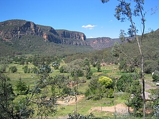
The Capertee Valley is a large canyon in New South Wales, Australia, 135 km (84 mi) north-west of Sydney that is noted to be the second widest of any canyon in the world, exceeding The Grand Canyon. It is located 135 km (84 mi) kilometres north-west of Sydney, between Lithgow and Mudgee, in the Central Tablelands, just above the Blue Mountains.

Kerosene Vale is a historic locality within the City of Lithgow Local Government Area of New South Wales, Australia. Kerosene Vale lies near Lidsdale and Wallerawang. It is considered part of Lidsdale for census purposes. It should not be confused with Hartley Vale, another locality with a history of shale oil production, which is also within the City of Lithgow. The name Kerosene Vale is now only used infrequently.

There are oil shale deposits in Australia which range from small deposits to large reserves. Deposits, varying by their age and origin, are located in about a third of eastern Australia. In 2012, the demonstrated oil shale reserves were estimated at 58 billion tonnes. The easiest to recover deposits are located in Queensland.

<span class="mw-page-title-main">Glen Davis Shale Oil Works</span> Oil extraction plant

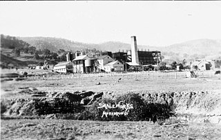
The Glen Davis Shale Oil Works was a shale oil extraction plant, in the Capertee Valley, at Glen Davis, New South Wales, Australia, which operated from 1940 until 1952. It was the last oil-shale operation in Australia, until the Stuart Oil Shale Project in the late 1990s. For the period of 1965–1952, it provided one fifth of the shale oil produced in Australia.

Commonwealth Oil Corporation Limited was an English-owned Australian company associated with the production and refining of petroleum products derived from oil shale, during the early years of the 20th century. It is associated with Newnes, Hartley Vale, and Torbane, all in New South Wales. It should not be confused with Commonwealth Oil Refineries, which was a completely separate company, established in 1920, that refined imported crude oil from 1924.

<span class="mw-page-title-main">Collits' Inn</span> Historic site in New South Wales, Australia

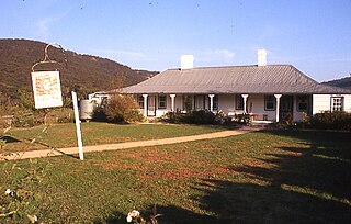
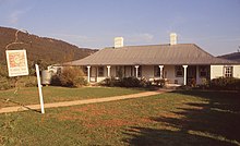
Collits' Inn is a heritage-listed former inn and now functions, accommodation and restaurant at Hartley Vale Road, Hartley Vale, City of Lithgow, New South Wales, Australia. It was designed by Pierce Collits and built in 1823. It is also known as Collitts Inn and Golden Fleece Inn. It was added to the New South Wales State Heritage Register on 2 April 1999.

Torbane was a privately-owned village lying within the area now known as Capertee, in the Local Government Area of the City of Lithgow, within the Central West region of New South Wales, Australia. There was also another village, Airly, nearby. Both villages were associated with the mining of oil shale. The mine associated with Torbane was known as the New Hartley Mine. and that associated with Airly was known as the Genowlan Mine. There were retorts that produced crude shale oil at Torbane. Both Torbane and Airly are now ghost towns.

<span class="mw-page-title-main">John Fell (industrialist)</span> Scottish-born Australian industrialist

John Wilson Fell (1862–1955) was an industrialist involved in the shale oil operations at Newnes, New South Wales and the establishment of two early oil refineries, on Gore Bay at Greenwich and at Clyde, both suburbs of Sydney. He was the principal of John Fell & Company and was, for many years, the Managing Director of Commonwealth Oil Corporation, which he revived from receivership.

<span class="mw-page-title-main">British Australian Oil Company</span> Former shale oil company of Australia

The British Australian Oil Company Limited was a British-owned company—incorporated in 1910—that mined oil shale and produced shale oil and refined oil products, in New South Wales, Australia, during the years from 1911 to 1915.

The New South Wales Shale and Oil Company — established in 1872, by the merging of two earlier ventures — mined and processed oil shale to produce kerosene, paraffin wax and candles, and other petroleum products, in New South Wales Australia. It is particularly associated with the sites of its former works, at Hartley Vale and Torbane. Its assets were bought by Commonwealth Oil Corporation in 1906.

Australian Kerosene Oil Company or 'A.K.O' mined and processed oil shale to produce kerosene, paraffin wax and candles, lubricating oil and greases, and other petroleum-based products, in New South Wales Australia. It is particularly associated with the site of its mine and works, at Joadja. At times, it also had other mining operations, at Airly and near Katoomba, and a soap and candle factory at Camellia. The company used the brand name 'Southern Cross' for its kerosene products.

Lisdale is a locality within the City of Lithgow Local Government Area of New South Wales, Australia. It lies to the north of Wallerawang. Its area, as defined for postal and statistical purposes, includes the historic locality of Kerosene Vale and the small rural areas known as Springvale and Angus Place. In 2021, its population was 471.

References

  1. Australian Bureau of Statistics (28 June 2022). "Hartley Vale (Suburb and Locality)". Australian Census 2021 QuickStats. Retrieved 28 June 2022.  OOjs UI icon edit-ltr-progressive.svg
  2. 1 2 "Hartley". Blue Mountains Website. Retrieved 1 October 2008.
  3. 1 2 "Nomination of Hartley Valley NSW for inclusion in the National Heritage List under Sec 324c of the Environment Protection and Biodiversity Conservation Act 1999" (PDF). November 2012. pp. 20–22.
  4. "A Bridge Builder: Death of Norman Selfe, a distinguished career". The Sydney Morning Herald . National Library of Australia. 16 October 1911. p. 8. Retrieved 6 April 2013.
  5. "Hartley Vale Station". www.nswrail.net. Retrieved 28 April 2020.
  6. 1 2 "THE NEW SOUTH WALES SHALE AND OIL COMPANY'S MINE, HARTLEY VALE". Sydney Mail and New South Wales Advertiser . 29 August 1874. p. 276. Retrieved 3 November 2022.
  7. 1 2 "Site of oil-shale works, Hartley Vale | NSW Environment, Energy and Science". www.environment.nsw.gov.au. Retrieved 15 October 2020.
  8. "COMMONWEALTH OIL CORPORATION". Sydney Morning Herald. 18 December 1906. p. 9. Retrieved 26 April 2022.
  9. "HARTLEY VALE REFINERY". Star. 19 March 1910. p. 8. Retrieved 21 May 2022.
  10. "ABOUT TWENTY MEN PAID OFF AT HARTLEY". Bathurst Times. 20 August 1913. Retrieved 21 May 2022.
  11. "HARTLEY VALE". Sydney Morning Herald. 7 May 1914. Retrieved 8 June 2022.
  12. Paton, Neil (2004). Sydney and Blue Mountains Bushwalks. Kangaroo Press. pp. 336–338.
  13. "Nomination of Hartley Valley NSW for inclusion in the National Heritage List under Sec 324c of the Environment Protection and Biodiversity Conservation Act 1999" (PDF). November 2012. pp. 13, 14.
  14. Smith, Jim (1986). How to See the Blue Mountains. Second Back Row Press. p. 84.
  15. "Homepage". Official Lithgow Website. Retrieved 30 September 2008.
  16. "Collits' Inn". New South Wales State Heritage Register . Department of Planning & Environment. H00455. Retrieved 18 May 2018. CC BY icon.svg Text is licensed by State of New South Wales (Department of Planning and Environment) under CC-BY 4.0 licence .