
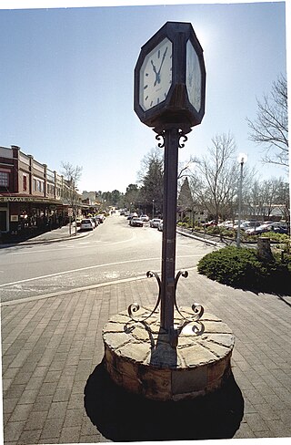
Katoomba is the chief town of the City of Blue Mountains in New South Wales, Australia, and the administrative headquarters of Blue Mountains City Council. Katoomba is located on the lands of the Dharug and Gundungurra Aboriginal peoples.

The Blue Mountains National Park is a protected national park that is located in the Blue Mountains region of New South Wales, in eastern Australia. The 267,954-hectare (662,130-acre) national park is situated approximately 80 kilometres (50 mi) west of the Sydney CBD, and the park boundary is quite irregular as it is broken up by roads, urban areas and areas of private property. Despite the name mountains, the area is an uplifted plateau, dissected by a number of larger rivers. The highest point in the park is Mount Werong at 1,215 metres (3,986 ft) above sea level; while the low point is on the Nepean River at 20 metres (66 ft) above sea level as it leaves the park.

The Nattai National Park is a protected national park that is located in the Macarthur and Southern Highlands regions of New South Wales in Australia. The 48,984-hectare (121,040-acre) area is situated approximately 150 kilometres (93 mi) southwest of the Sydney central business district and primarily encompasses the valley of the Nattai River, which is surrounded by sandstone cliffs. Part of the Southern Highlands Shale Forest and Woodland, the park is covered in dry sclerophyll (hard-leafed) forest – mostly eucalypt, and has frequent forest fires. As of May 2024, the park has no facilities.

Richmond is a historic town in north-west of Sydney, New South Wales, Australia. Richmond is in local government area of City of Hawkesbury and comes under Sydney Metropolitan area. It is located 20 metres above sea level on the alluvial Hawkesbury River flats, at the foot of the Blue Mountains. It is about 65 km by road from Sydney, 22 km from Penrith, 26 km from Blacktown, 40 km from Parramatta, 78 km from Lithgow and 5 km from Windsor. Richmond Town is now part of Sydney urban area have all amenities including Shopping Malls, Service NSW, Schools, TAFE, University, Post Office, Restaurants, Railway Station, Cafe, Hotel and Supermarkets.

Oberon is a town located within the Oberon Council local government area, in the central tablelands region of New South Wales, Australia. The main industries are farming, forestry and wood products. The town usually receives snowfall during the winter months, owing to its high elevation. At the 2021 census, Oberon had a population of 3,319 people.

Lithgow is a town in the Central Tablelands of New South Wales, Australia and is the administrative centre of the City of Lithgow local government area. It is located in a mountain valley named Lithgow's Valley by John Oxley in honour of William Lithgow, the first Auditor-General of New South Wales.

The Gondwana Rainforests of Australia, formerly known as the Central Eastern Rainforest Reserves, are the most extensive area of subtropical rainforest in the world. Collectively, the rainforests are a World Heritage Site with fifty separate reserves totalling 366,500 hectares from Newcastle to Brisbane.

Glenbrook is a township of the Lower Blue Mountains of New South Wales, Australia. It is located 63 kilometres west of the Sydney central business district, in the local government area of the City of Blue Mountains. As of the 2021 Australian census Glenbrook had a population of 5,078 people.

Lawson is a town in the Blue Mountains area of New South Wales, Australia. It is located on the Great Western Highway between Hazelbrook in the east and Bullaburra in the west. Lawson has a station on the Main Western line. The town is also served by a public swimming pool and over the years has developed into the commercial hub of the mid-mountains area, which spans from Linden to Bullaburra, boasting a significant industrialized area as well as a shopping centre located on the south-eastern side of the highway.
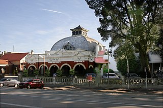
Medlow Bath is a village located near the highest point of the Blue Mountains, New South Wales, Australia. Located between Katoomba and Blackheath, its altitude is about 1,050 metres (3,440 ft) AHD . It is about 115 kilometres (71 mi) west-north-west of the Sydney central business district and 5 kilometres (3.1 mi) north-west of Katoomba. At the 2016 census, Medlow Bath had a population of 611 people.

Springwood is a town in the Blue Mountains, New South Wales, Australia. Springwood is located 72 kilometres west of the Sydney CBD in the local government area of the City of Blue Mountains. At the 2021 census, Springwood had a population 8,423 people.

Linden is a village in the Blue Mountains of New South Wales, Australia. It is in the City of Blue Mountains, 82 km west of Sydney and 23 km east of Katoomba. The village is on the Great Western Highway and has a railway station on the Main Western railway line served by NSW TrainLink's Blue Mountains Line. It shares a post office, and therefore the 2778 postcode, with adjoining Woodford. In the 2011 census, its population was 594, including 19 indigenous people (3.2%).

The City of Blue Mountains is a local government area of New South Wales, Australia, governed by the Blue Mountains City Council. The city is located in the Blue Mountains, on the Great Dividing Range at the far western fringe of the Greater Sydney area. Major settlements include, Katoomba, Lawson, Springwood and Blaxland.
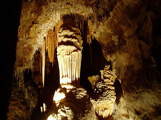
The Jenolan Caves are limestone caves located within the Jenolan Karst Conservation Reserve in the Central Tablelands region, west of the Blue Mountains, in Jenolan, Oberon Council, New South Wales, in eastern Australia. The caves and 3,083-hectare (7,620-acre) reserve are situated approximately 175 kilometres (109 mi) west of Sydney, 20 kilometres (12 mi) east of Oberon and 30 kilometres (19 mi) west of Katoomba. Dating back to 340million years ago, it is the oldest known and dated open cave system in the world.
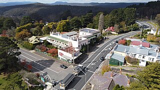
Mount Victoria is a village in the Blue Mountains of New South Wales, Australia. Mount Victoria is geographically the western most village and suburb of Greater Sydney on the great western highway in the City of Blue Mountains, located about 120 kilometres (75 mi) west-northwest by road from the Sydney central business district and at an altitude of about 1,052 metres (3,451 ft) AHD . The settlement had a population of 823 people at the 2011 Census.
Wentworth Falls is a town in the Blue Mountains region of New South Wales, situated approximately 100 kilometres (62 mi) west of the Sydney central business district, and about 8 kilometres (5.0 mi) east of Katoomba, Australia on the Great Western Highway, with a Wentworth Falls railway station on the Main Western line. The town is at an elevation of 867 metres (2,844 ft) AHD . At the 2016 census, Wentworth Falls had a population of 6,076.

Hartley is a historical village in the Central West region of New South Wales, Australia, within the City of Lithgow local government area, located approximately 127 kilometres (79 mi) west of Sydney. Hartley is located below the western escarpment of the Blue Mountains.
The Coxs River track is a heritage-listed former walking track and road and now walking track at Cox's River Arms, Lake Burragorang/Warragamba Dam, City of Blue Mountains, New South Wales, Australia. The track is also known as the Warragamba Dam - Burragorang Valley - Wentworth Falls Track. The property is owned by the Sydney Catchment Authority, an agency of the Government of New South Wales. It was added to the New South Wales State Heritage Register on 18 November 1999.

Prospect Nature Reserve is a nature reserve and recreational area that is situated in the western suburbs of Sydney, New South Wales, Australia, which incorporates the Prospect Reservoir, and also features picnic spots, lookouts, walking tracks and BBQ areas within the Australian bush. It is located within the Blacktown City local government area, but is also close to the boundaries of Cumberland Council and the City of Fairfield.

The Beauchamp Falls is a cascade waterfall on the Greaves Creek where it spills into the Grose Valley, located east of the Evans Lookout, approximately 2.5 kilometres (1.6 mi) east of Blackheath in the Blue Mountains region of New South Wales, Australia.


