The Parramatta River is an intermediate tide-dominated, drowned valley estuary located in Sydney, New South Wales, Australia. With an average depth of 5.1 metres (17 ft), the Parramatta River is the main tributary of Sydney Harbour, a branch of Port Jackson. Secondary tributaries include the smaller Lane Cove and Duck rivers.

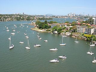
Homebush Bay is a bay on the south bank of the Parramatta River, in the west of Sydney, Australia. The name is also sometimes used to refer to an area to the west and south of the bay itself, which was formerly an official suburb of Sydney, and has now become the suburbs of Sydney Olympic Park, Wentworth Point and part of the neighbouring suburb of Lidcombe, all part of the City of Parramatta. Homebush Bay is located 13 kilometres (8.1 mi) west of the Sydney central business district.

Homebush is a suburb in the Inner West of Sydney in the state of New South Wales, Australia. It is located 12 kilometres west of the Sydney central business district, in the local government area of the Municipality of Strathfield.

Great Western Highway is a 202-kilometre-long (126 mi) state highway in New South Wales, Australia. From east to west, the highway links Sydney with Bathurst, on the state's Central Tablelands.

The Inner West of Sydney is an area directly west of the Sydney central business district, New South Wales, Australia. The suburbs that make up the Inner West are predominantly located along the southern shore of Port Jackson, stretching south to the shores of the Cooks River. The western boundary of the Inner West is approximately the A3 arterial road, which divides the Inner West from the Greater Western Sydney region. The Inner West is much larger than the Inner West Council local government area. The Inner West roughly corresponds with the Parish of Petersham and Parish of Concord, two cadastral divisions used for land titles.

Lidcombe railway station is located on the Main Suburban line, serving the Sydney suburb of Lidcombe. It is served by Sydney Trains T1 Western, T2 Inner West & Leppington, T3 Bankstown and T7 Olympic line services.

Rookwood is a suburb in western Sydney, in the state of New South Wales, Australia located 14 kilometres (8.7 mi) west of the Sydney central business district, in the local government area of the Cumberland Council. It is the easternmost suburb in greater western Sydney.
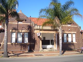
Lidcombe is a suburb in western Sydney, in the state of New South Wales, Australia. Lidcombe is located 15 km (9.32 mi) west of the Sydney central business district, in the local government area of Cumberland Council, with a small industrial part in the north in the City of Parramatta. Post code: 2141, sharing it with Berala.

Flemington, officially gazetted as "Homebush West" since 1992, is a suburb in the Inner West of Sydney, in the state of New South Wales, Australia. Flemington is located 13 kilometres west of the Sydney central business district, in the local government area of the Municipality of Strathfield, with a small unpopulated area in Cumberland Council.
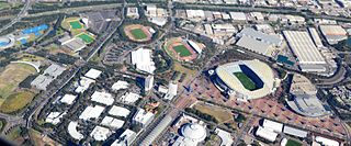
Sydney Olympic Park is a suburb of Greater Western Sydney, located 13 kilometres west of the Sydney central business district, in the local government area of the City of Parramatta Council. It is commonly known as Olympic Park but officially named Sydney Olympic Park. The area was part of the suburb of Lidcombe and known as "North Lidcombe", but between 1989 and 2009 was named "Homebush Bay". The names "Homebush Bay" and, sometimes, "Homebush" are still used colloquially as a metonym for Stadium Australia as well as the Olympic Park precinct as a whole, but Homebush is an older, separate suburb to the southeast, in the Municipality of Strathfield.

The M4 Motorway is a 55-kilometre (34 mi) series of partially tolled dual carriageway motorways in Sydney designated as route M4. The M4 designation is part of the wider A4 and M4 route designation, the M4 runs parallel and/or below ground to Great Western Highway, Parramatta Road and City West Link, which are part of route A44.

Iron Cove Creek, a southern tributary of the Parramatta River, is an urban stream west of Sydney Harbour, located in the inner-western Sydney suburbs of Croydon, Ashfield, Haberfield and Five Dock in New South Wales, Australia.

Bicentennial Park is a 40-hectare (99-acre) suburban parkland located 16 kilometres (9.9 mi) west of the Sydney central business district in the suburb of Sydney Olympic Park, in the local government area of City of Parramatta, New South Wales, Australia. Bicentennial Park is situated on the shores of Homebush Bay and is a part of the Sydney Olympic Park. The park is a natural heritage site featuring an important wetland ecosystem and parklands.
Powells Creek, a southern tributary of the Parramatta River, is an urban stream west of Sydney Harbour, located in Sydney, Australia. It flows through Sydney Olympic Park and joins Parramatta River at Homebush Bay.
Saleyards Creek is a canalised urban stream, acting as a stormwater channel, located in Sydney, Australia. Its upstream course follows approximately the boundary between the suburbs of Homebush and Flemington. North of Parramatta Road, both sides of the creek fall within Homebush.

The Duck River is a perennial stream and southern tributary of the Parramatta River, in Sydney, New South Wales, Australia.
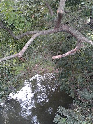
Vineyard Creek, a northern tributary of the Parramatta River, is a creek in Sydney, Australia.

Wentworth Point is a suburb of Sydney, in the state of New South Wales, Australia. It is located 13 kilometres west of the Sydney central business district, on the eastern edge of the local government area of City of Parramatta. It is on the western shore of Homebush Bay on the southern side of the Parramatta River. Wentworth Point is usually regarded as part of the Greater Western Sydney region, including in administrative contexts, but it is also regarded as part of the Inner West region of Sydney in some contexts, especially commercial contexts.

The Olympic Park railway line is a railway line linking the Sydney Olympic Park precinct to the Main Suburban railway line at Flemington and Lidcombe. Originally opened as the Abattoirs branch in 1911, it was rebuilt and reopened as the Olympic Park railway line in 1998. Passenger services have since been running on it as the Olympic Park Line.
The M4 cycleway is a 15-kilometre-long (9.3 mi) shared use path for cyclists and pedestrians that is generally aligned with the M4 Motorway in Sydney, New South Wales, Australia. The eastern terminus of the cycleway is in Sydney Olympic Park, while the western terminus is in South Wentworthville.
