Newington, New South Wales

Last updated

Newington
Sydney,  New South Wales
Newington Marketplace.JPG
Newington Marketplace
Newington, New South Wales
Population5,802 (2016 census) [1]
 • Density6,240/km2 (16,160/sq mi)
Established2002
Postcode(s) 2127
Elevation18 m (59 ft)
Area0.93 km2 (0.4 sq mi)
Location18 km (11 mi) west of Sydney CBD
LGA(s) City of Parramatta
State electorate(s) Auburn
Federal division(s) Reid
Suburbs around Newington:
Silverwater Ermington Wentworth Point
Silverwater Newington Sydney Olympic Park
Auburn Lidcombe Lidcombe

Newington is a western suburb of Sydney, in the state of New South Wales, Australia. It is 16 kilometres west of the Sydney central business district, in the local government area of City of Parramatta.

Contents

Newington is 2 km west of Wentworth Point, on the Parramatta River, and 1 km north-west of Sydney Olympic Park. It is best known as the location of the Athletes Village for the 2000 Summer Olympics and 2000 Summer Paralympics. The Athlete's Village was converted to residential apartments after the Olympic Games and Paralympic Games. Other apartments and free-standing houses have also been built since. A reserve opposite Newington Marketplace memorial features a complete roster of the Australian team at the 2000 Summer Olympics and 2000 Summer Paralympics.

History

The suburb of Newington took its name from the Newington Estate which was named by John Blaxland after his family estate in Kent, England. [2]

Aboriginal culture

Newington is situated on the traditional aboriginal lands of the Wann clan, known as the Wann-gal. The lands of the Wann-gal stretched along the southern shore of the Parramatta River between Cockle Bay (Cadi-gal land) and Parramatta (Burramatta-gal land). The opposite Parramatta River bank was occupied by the Wallumetta-gal.

European settlement

Within ten days arrival of the First Fleet in Australia, plat records were made of "The Flats", the extensive tidal wetlands at Homebush Bay. From 1788 to 1831, land grants in blocks of 100 to 10,000 acres (40 km2) were distributed to the European settlers from the Wanng-al clans holdings. Official County of Cumberland maps were annotated with the names and boundaries of the new land owners.

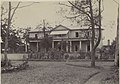
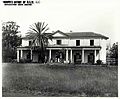
In 1807, John Blaxland acquired 520 hectares of land, originally reserve grants of Waterhouse, Shortland, Archer and Haslam. He named the estate Newington after his family estate in Kent, England. Blaxland established a series of salt pans on the banks of the Parramatta River and by 1827, was producing 8 tons of salt each week for the Sydney market. Blaxland also established a tweed mill, limekiln and flourmill. Newington House was completed in 1832 and St Augustine's Chapel in 1838.

In 1843, Blaxland mortgaged the property to the Australian Trust Company. The mortgage went unpaid at the time of his death in 1851. John Dobie purchased the property from the Trust Company to paid off the mortgage. The Blaxland family re-purchased the estate from Dobie in 1854 and offered it as security against a large loan. The property was transferred to the Official Assignee of the Insolvent Estate of Edward James Blaxland in 1860 and subsequently leased to the Methodist Church, who established Newington College on the site. The property, extending from near the current Holker Street to the current Carnarvon Street, was sold to John Wetherill in 1877.

Coal mining explorations were undertaken by Blaxland in 1841. He dug several six metre pits which gained the interest of the Australian Mining Company. The two parties reached agreement and, subsequently, undertook several unsuccessful explorations. In 1878, the City of Sydney Coal Company acquired the right to bore for coal at the site. The company drilled to 457 metres with no success. In 1855 the Australian Timber Company formed to exploit the timber stands in the Newington and surrounding areas. In the late 1870s and 1880s, Sydney's suburbs were expanding rapidly and it was hoped that the creation of a residential settlement between the large centres of Sydney and Parramatta would be a profitable exercise. This did not prove to be the case.

In 1878, John Wetherill registered a subdivision plan for the entire 520 hectare Newington Estate. This proposal comprised an extensive grid layout, of some 114 lots, which extended well into the mud flats and mangroves of Wentworth Bay and Homebush Bay. In 1906 and 1909, Wetherill further subdivided his property as Riverside Heights, with the first allotments sold in that year. It was hoped that the location of the subdivision in close proximity to the developing State Abattoir and Brickworks would attract people to the area in association with the employment opportunities offered by these establishments. This venture was largely unsuccessful, with only a few lots being sold. However the layout of the western part of the Newington subdivision remains obvious in the current street pattern and street names. [3]

Early public use

The Newington Estate was first offered in 1874 to the Government for use as an Asylum for the Insane. The Government did not accept this offer, however in 1879, Government Architect James Barnet prepared a report on the suitability of the Newington estate for a Reformatory School for Boys. His report concluded that the site was suitable for a Boys Reformatory or a Benevolent Asylum for Aged Women. In September 1897 the Crown Solicitor confirmed that 5000 pounds would be paid to John Wetherill to acquire about 19 hectares of land, which included Newington House.

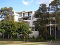
An Aged Women's Asylum was constructed to replace the existing asylum which was housed within the Immigrant Depot at the Hyde Park Barracks. The first buildings were established in 1886 on this new site to house 300 patients. At this time, the hospital was categorised as a state asylum for dependent adults' with infirmity or illness of 'incurable character'. Various additional buildings and structures were added to the Newington Hospital over the years. In 1960 it was proposed that the hospital should be closed and the site sold to industry. The significance of the site, however, stimulated significant public opposition to the plans. In 1968, after a series of drawn out negotiations, the Government of the day decided to close the hospital and transfer the property to the then NSW Department of Prisons. Some of the buildings are preserved in the grounds of the Metropolitan Remand and Reception Centre where they are still in use. [3] In the late 1990s the site was developed by Mirvac and Lend Lease for the purpose of an athletes' village for the 2000 Summer Olympics. Following the conclusion of the Games the site was developed into a new residential suburb by Mirvac.

Commercial areas

Newington Marketplace is an outdoor shopping centre featuring a Woolworths supermarket and specialty shops, cafes and restaurants. Newington also features a number of commercial buildings providing office and warehouse space.

Schools

See also

Related Research Articles

<span class="mw-page-title-main">Rhodes, New South Wales</span> Suburb of Sydney, New South Wales, Australia

Rhodes is an Inner West suburb of Sydney, in the state of New South Wales, Australia. Rhodes is located 12 kilometres west of the Sydney central business district, in the local government area of the City of Canada Bay. It was formerly part of Concord Municipality until a merger with Drummoyne Council to form Canada Bay in December 2000.

<span class="mw-page-title-main">Parramatta River</span> River in Australia

The Parramatta River is an intermediate tide-dominated, drowned valley estuary located in Sydney, New South Wales, Australia. With an average depth of 5.1 metres (17 ft), the Parramatta River is the main tributary of Sydney Harbour, a branch of Port Jackson. Secondary tributaries include the smaller Lane Cove and Duck rivers.

<span class="mw-page-title-main">Homebush Bay</span> Suburb of Sydney, New South Wales, Australia

Homebush Bay is a bay on the south bank of the Parramatta River, in the west of Sydney, Australia. The name is also sometimes used to refer to an area to the west and south of the bay itself, which was formerly an official suburb of Sydney, and has now become the suburbs of Sydney Olympic Park, Wentworth Point and part of the neighbouring suburb of Lidcombe, all part of the City of Parramatta. Homebush Bay is located 13 kilometres (8.1 mi) west of the Sydney central business district.

<span class="mw-page-title-main">Homebush, New South Wales</span> Suburb of Sydney, New South Wales, Australia

Homebush is a suburb in the Inner West of Sydney in the state of New South Wales, Australia. It is located 12 kilometres west of the Sydney central business district, in the local government area of the Municipality of Strathfield.

<span class="mw-page-title-main">Inner West</span> Region in New South Wales, Australia

The Inner West of Sydney is an area directly west of the Sydney central business district, New South Wales, Australia. The suburbs that make up the Inner West are predominantly located along the southern shore of Port Jackson, stretching south to the shores of the Cooks River. The western boundary of the Inner West is approximately the A3 arterial road, which divides the Inner West from the Greater Western Sydney region. The Inner West is much larger than the Inner West Council local government area. The Inner West roughly corresponds with the Parish of Petersham and Parish of Concord, two cadastral divisions used for land titles.

<span class="mw-page-title-main">West Ryde, New South Wales</span> Suburb of Sydney, New South Wales, Australia

West Ryde is a suburb of Sydney, in the state of New South Wales, Australia. West Ryde is located 16 kilometres north-west of the Sydney central business district, in the local government area of the City of Ryde and is part of the Northern Sydney region.

<span class="mw-page-title-main">Silverwater</span> Suburb of Sydney, New South Wales, Australia

Silverwater is a suburb in western Sydney, in the state of New South Wales, Australia. Silverwater is located 15 kilometres west of the Sydney central business district on the southern bank of the Parramatta River within the local government area of City of Parramatta.

<span class="mw-page-title-main">Lidcombe</span> Suburb of Sydney, New South Wales, Australia

Lidcombe is a suburb in western Sydney, in the state of New South Wales, Australia. Lidcombe is located 15 km (9.32 mi) west of the Sydney central business district, in the local government area of Cumberland Council, with a small industrial part in the north in the City of Parramatta. Post code: 2141, sharing it with Berala.

<span class="mw-page-title-main">Ermington, New South Wales</span> Suburb of Sydney, New South Wales, Australia

Ermington is a suburb of Sydney, New South Wales, Australia. Ermington is located 19 kilometres West of the Sydney central business district, in the local government area of the City of Parramatta. Ermington lies on the northern bank of the Parramatta River.

<span class="mw-page-title-main">Flemington, New South Wales</span> Suburb of Sydney, New South Wales, Australia

Flemington, officially gazetted as "Homebush West" since 1992, is a suburb in the Inner West of Sydney, in the state of New South Wales, Australia. Flemington is located 13 kilometres west of the Sydney central business district, in the local government area of the Municipality of Strathfield, with a small unpopulated area in Cumberland Council.

<span class="mw-page-title-main">Sydney Olympic Park</span> Suburb of Sydney, New South Wales, Australia

Sydney Olympic Park is a suburb of Greater Western Sydney, located 13 kilometres west of the Sydney central business district, in the local government area of the City of Parramatta Council. It is commonly known as Olympic Park but officially named Sydney Olympic Park. The area was part of the suburb of Lidcombe and known as "North Lidcombe", but between 1989 and 2009 was named "Homebush Bay". The names "Homebush Bay" and, sometimes, "Homebush" are still used colloquially as a metonym for Stadium Australia as well as the Olympic Park precinct as a whole, but Homebush is an older, separate suburb to the southeast, in the Municipality of Strathfield.

<span class="mw-page-title-main">John Blaxland (explorer)</span> Australian politician

John Blaxland was a pioneer settler and explorer in Australia.

<span class="mw-page-title-main">Newington House</span> House in New South Wales, Australia

Newington House is a historic house in Silverwater, New South Wales, Australia and is located 20 kilometres (12 mi) west of the Sydney central business district, in the local government area of the City of Parramatta. The house and chapel are situated on the southern bank of the Parramatta River and are now enclosed by the Silverwater Correctional Centre. With Elizabeth Bay House and Camden Park, it is considered to be one of the three great houses of the County of Cumberland.

<span class="mw-page-title-main">Newington Armory</span> Historic site in New South Wales, Australia

Newington Armory is a heritage-listed former Royal Australian Navy armament depot, now used for tourism purposes, at Holker Street, Sydney Olympic Park, Cumberland Council, New South Wales, Australia. It was built from 1897 initially by the New South Wales Military Forces then by the Australian Army and later by the Royal Australian Navy. It is also known as Millennium Heritage Parklands Precinct, RAN Armament Depot Newington, Royal Australian Navy Armament Depot (RANAD), Newington Nature Reserve and Sydney Olympic Games site. The property is owned by the Sydney Olympic Park Authority. It was added to the New South Wales State Heritage Register on 14 January 2011.

<span class="mw-page-title-main">Haslams Creek</span> River in Australia

Haslams Creek, a southern tributary of the Parramatta River, is a creek west of Sydney Harbour, located in Sydney, Australia. It flows through Sydney Olympic Park and joins Parramatta River at Homebush Bay. In 1793, the first grants were made to free settlers, with Samuel Haslam receiving his first grant in 1806. A 50 acre grant north of Parramatta Road, the first grant, was followed by a second small grant south of Parramatta Road and east of Haslams Creek. Haslams Creek flowed through the holdings of the Sydney Meat Preserving Company Ltd 1876-1965, which at one point damned the creek. When opened, Lidcombe railway station actually bore the name Haslams Creek Station

<span class="mw-page-title-main">Wentworth Point, New South Wales</span> Suburb of Sydney, New South Wales, Australia

Wentworth Point is a suburb of Sydney, in the state of New South Wales, Australia. It is located 13 kilometres west of the Sydney central business district, on the eastern edge of the local government area of City of Parramatta. It is on the western shore of Homebush Bay on the southern side of the Parramatta River. Wentworth Point is usually regarded as part of the Greater Western Sydney region, including in administrative contexts, but it is also regarded as part of the Inner West region of Sydney in some contexts, especially commercial contexts.

<span class="mw-page-title-main">Louise Sauvage Pathway</span>

Located alongside the suburb of Newington, New South Wales, and named in honour of Australian paralympic wheelchair racer Louise Sauvage, the Pathway is the longest continuous section of pathway in Sydney Olympic Park. As such, the pathway is suitable for walking and pushbikes, as well as wheelchairs.

<span class="mw-page-title-main">Silverwater Prison Complex Conservation Area</span> Historic site in New South Wales, Australia

Silverwater Prison Complex Conservation Area is a heritage-listed complex consisting of a historic house and various prison structures associated with what is now known as the Silverwater Correctional Complex, located at Holker Street, Silverwater, Cumberland Council, New South Wales, Australia. It was designed by John Verge and Walter Liberty Vernon and built from 1829 to 1850. It is also known as Silverwater Correctional Centre, Mulawa Correctional Centre, Silverwater Gaol, Newington Estate, Silverwater State Hospital and State Hospital & Asylum for Women. The property is owned by Corrective Services NSW. It was added to the New South Wales State Heritage Register on 2 April 1999.

<span class="mw-page-title-main">Brickpit Ring Walk</span>

The Brickpit Ring Walk is an urban nature park and walkway that serves as a water storage and frog habitat in the Bicentennial Park, in Sydney Olympic Park, New South Wales, Australia. Once a brick manufacturing site, the land was to be redeveloped as part of the site for the 2000 Sydney Olympic and Paralympic Games, however the 1992 discovery of the then endangered Green and Golden Bell Frog placed a hold on developments. The urban nature park and walkway was established in 2006.

<span class="mw-page-title-main">Brush Farm</span> Historic site in New South Wales, Australia

Brush Farm is a heritage-listed former farm, residence and vineyard and now tourist attraction, community facility, exhibition venue and meeting venue at Marsden Road, Eastwood of the City of Ryde local government area of New South Wales, Australia. It was built from 1794 to 1894. It is also known as Home for Boys, Eastwood Home for Mothers and Babies and Brush Farm Home for Mentally Deficient Children, and Brush Farm Girls' Home. The property is owned by City of Ryde. It was added to the New South Wales State Heritage Register on 2 April 1999.

References

  1. Australian Bureau of Statistics (27 June 2017). "Newington (NSW) (State Suburb)". 2016 Census QuickStats. Retrieved 21 December 2017. OOjs UI icon edit-ltr-progressive.svg
  2. The Book of Sydney Suburbs, Compiled by Frances Pollon, Angus & Robertson Publishers, 1990, Published in Australia ISBN   0-207-14495-8
  3. 1 2 Sydney Olympic Park Authority – Five Layers of History Archived 8 May 2006 at the Wayback Machine

33°50′20″S151°03′18″E / 33.839°S 151.055°E / -33.839; 151.055