Epping, New South Wales

Last updated

Epping
Sydney,  New South Wales
Beecroft road-epping-1w.jpg
Beecroft Road, Epping
Epping, New South Wales
Map
Population29,551 (2021 census) [1]
 • Density4,320/km2 (11,190/sq mi)
Established1899
Postcode(s) 2121
Elevation98 m (322 ft)
Area6.84 km2 (2.6 sq mi)
Location18 km (11 mi) north-west of Sydney CBD
LGA(s) City of Parramatta
Region
State electorate(s)
Federal division(s) Bennelong
Suburbs around Epping:
Beecroft Cheltenham North Epping
Carlingford Epping Marsfield
Eastwood Eastwood Marsfield

Epping is a suburb of Sydney, in the Australian state of New South Wales, 18 kilometres north-west of the Sydney central business district in the local government area of the City of Parramatta. Epping is in the Northern Sydney region. [2] [3] The suburb is the most north-eastern area of the City of Parramatta. North Epping is a separate suburb to the north and under a different council, Hornsby Shire.

Contents

History

The Wallumettagal Aboriginal tribe lived in the area between the Lane Cove River and Parramatta River. [4] In 1792, Governor Arthur Phillip began the granting of parcels of lands to marines, and the area was referred to on Phillip's maps as the Field of Mars, Mars being the Roman god of war. It contained the area of what is now Epping, along with the surrounding suburbs of Ryde and Marsfield.

Epping railway station was opened on 17 September 1886, originally named "Field of Mars", and quickly renamed to "Carlingford" on 5 April 1887. [5] The Post Office was opened on 16 October 1889, originally named "East Carlingford".

Sonter family packing fruit, Ray Road, Epping, Sydney, 1911 Sonter family packing fruit Epping 1911.jpg
Sonter family packing fruit, Ray Road, Epping, Sydney, 1911

In 1899 the suburb name of Epping was adopted following the suggestion by a local landowner William Midson (1849–1924), after a town near Epping Forest in Essex, where his father was born. [6] At this time, the names of the post office and the railway station were both changed to Epping. [7] [8] The land from the Field of Mars was broken up into farms and orchards, and after World War II it started to convert to residential use. Areas which had previously been reserved as part of the green belt scheme became available in 1948. [9]

The Seven Network had its headquarters and television production studios in Epping until 2009. The site is now occupied by residential apartments.

Until 2016, parts of Epping were under three different councils: Hornsby Shire, City of Ryde and City of Parramatta. A 2015 review of local government boundaries recommended that all of Epping be amalgamated into the City of Parramatta, and this became effective on 12 May 2016. [10] [11]

Commercial area

Epping Club Epping Club.JPG
Epping Club

Lands around Epping Railway Station are zoned for commercial use. There are businesses including newsagencies, pharmacies, Asian grocers and restaurants. To the west of the station, there is a Coles supermarket, a RSL Club and a pub (the Epping Hotel) on Rawson Street.

Redevelopment as "Urban Renewal Area"

A major re-development of the Epping Town Centre is planned as part of the NSW government's "Urban Renewal Area" programme (originally called the "Urban Activation Precincts" programme). The changes to zoning for this programme cover 54 hectares, including provision for building heights of 8 to 22 storeys for mixed commercial and residential use within a 400-metre radius of the railway station, and about 3,750 additional homes within 800 metres of it. [12] These zoning changes were finalized and approved in March 2014, although residents have expressed concerns about issues including traffic management, lack of parking, storm water drainage and access to schools. [13]

The first major project under this programme was scheduled to be Grocon's amalgamation of four lots at 30-42 Oxford Street, acquired in September 2015 for a cost of $56 million. Plans for a 16-storey development of more than 250 apartments for a total value of more than $300 million were lodged with the council. However, in early 2016 they sold the blocks. [14] [15] In late 2019, the "Oxford Central" development of 251 or 252 apartments, car parking and retail was completed on the site by developer Greaton and construction company Ceerose. [16] [17]

Transport

Epping railway station Epping Railway Station 1.JPG
Epping railway station

Epping railway station is a junction station on the Northern Line of the Sydney Trains network, the Central Coast & Newcastle Line of the NSW TrainLink network, and the rapid transit Sydney Metro Northwest since its opening on 26 May 2019. [18]

Bus services are operated by Busways and CDC NSW. The M2 Hills Motorway runs along the northern border to the Sydney central business district. Epping Road is a major arterial road in the area that runs east from the railway station to the Pacific Highway.

In spite of the range of public transport options, the 2021 census found that only 23% of employed people who travelled to work used public transport, compared to 74% who travelled by car (either as driver or as passenger). This census was conducted during the COVID-19 restrictions, and more people reported that they worked from home than travelled to work at the time. [1]

Community facilities

Epping Community Centre, originally known as the School of Arts Epping Community Centre 2014 04 17.JPG
Epping Community Centre, originally known as the School of Arts

The council and other organisations provide a number of community facilities. These include:

Some schools and churches also have halls and other facilities that can be made available for community uses.

Parks, playgrounds, sports fields

Rockleigh Park, Epping Rockleigh Park Epping 2014 04 16-a2.jpg
Rockleigh Park, Epping
NameAddressFacilities
Boronia Park [30] 37 Bridge St, EppingSporting field, cricket pitch, children's playground (shaded) with 6m climbing web, war memorial, children's bike track, seating, picnic shelters, barbecue, public toilets, change rooms
David Scott Reserve [31] 97 Midson Rd, EppingTennis courts, children's playground, seating, picnic tables
Duncan Park [32] 47 Kent St, EppingSporting field, croquet green
Epping Athletic Track [33] Norfolk Road, EppingAthletics track, toilets, car park
Epping Oval [34] Norfolk Road, EppingCricket pitch, practice nets, soccer field, toilets, car park
Epping Oval Playground [35] Norfolk Road, North EppingFenced playground unit, swings, 6m climbing tower, large double picnic shelter, open grassed area, BBQ, toilets
Forest Park [36] Forest Grove, EppingRose garden, war memorial, playground, picnic tables, toilets
Grant Close Netball Courts [37] Grant Close, EppingNetball courts, toilets
Henry Brigg Park (known as Maida Park until 2017 [38] )Maida Road corner of Essex Street, EppingSwing set, fenced
Kim Rutherford Reserve [39] 20 Wyralla Ave, EppingChildren's playground, seating
Loftus Square [40] 35 Willoughby St, EppingTwo children's playgrounds (junior & senior), seating, multipurpose courts, picnic facilities
North Epping Oval [41] Boundary Road, North EppingCricket pitch, soccer field, toilets, car park
Pembroke Street Park [42] 8 Pembroke Street corner of Chambers Court, EppingPlayground, fenced, picnic table
Rockleigh ParkEssex St, EppingSmall covered pergola
Ron Payne Park [43] Woods St, North EppingCricket pitch, practice nets, soccer field, toilets, car park
Somerville Oval [44] Blaxland Road, EppingCricket pitch, practice nets, rugby field, toilets, car park
West Epping Oval [45] Downing street, EppingCricket pitch, practice nets, soccer field, toilets, car park

Churches

St Alban's Anglican Church Epping Anglican Church.JPG
St Alban's Anglican Church

Schools

Formerly the American International School of Sydney was located here, until its closure in 2009. [48]

Demographics

Historical population
YearPop.±%
200118,065    
200618,970+5.0%
201120,227+6.6%
201623,688+17.1%
202129,551+24.8%

According to the Australian Bureau of Statistics' 2021 census, Epping had a population of 29,551, of whom 48.5% were male and 51.5% were female. They were further broken down as follows:

Ethnic diversity
36.7% of people were born in Australia. The next most common countries of birth were China 19.7%, India 9.5%, South Korea 7.4%, Hong Kong 5.4% and Malaysia 1.7%. 30.9% of people only spoke English at home. Other languages spoken at home included Mandarin 23.1%, Cantonese 12.1%, Korean 9.3%, Hindi 3.5% and Tamil 1.9%. [1]
Age distribution
The median age of people in Epping was 36 years (national median is 38). Children aged under 15 years made up 19.0% of the population (18.2% nationally) and people aged 65 years and over made up 13.6% of the population (17.2% nationally). [1]
Income
Median weekly household income was $2,243, compared to the national median of $1,746. [1]
Housing
More than three quarters (78.1%) of private dwellings were family households, 17.4% were single person households and 4.4% were group households. Stand-alone houses accounted for 42.6% of occupied dwellings, down from 55.5% five years earlier in 2016. Another 47.4% were flats, units or apartments (up from 32.2% in 2016) and 9.8% were semi-detached. The average household size was 2.8 people. [1]
Religion
The most commonly reported religious affiliation in the 2021 census was No Religion 40.9%, followed by Catholic 12.2%, Hinduism 9.8%, Anglican 6.0%, and Buddhism 5.5%. In the twenty years from 2001 to 2021, the Census shows that the largest change in religion was the number of people who were not affiliated with any religion, which increased from 16.6% to 40.9% of the population. [1] [49]

Government

At a local government level, Epping lies solely within the City of Parramatta Local Government Area. [50]

At a state level, Epping is mostly represented by the electoral district of Epping, with a small area on the southern edge of Chesterfield Road that is within the Electoral district of Ryde.

At a federal level, Epping falls in the Division of Bennelong.

Related Research Articles

<span class="mw-page-title-main">Castle Hill, New South Wales</span> Suburb of Greater Western Sydney, New South Wales, Australia

Castle Hill is a suburb of Sydney, New South Wales, Australia, located 34 kilometres north-west of the Sydney central business district and 9.5 kilometres north of Parramatta. It is within the Hills District region, split between the local government areas of The Hills Shire and Hornsby Shire.

<span class="mw-page-title-main">Epping to Chatswood rail link</span>

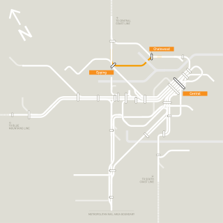
The Epping to Chatswood rail link (ECRL) (originally a part of the Parramatta Rail Link (PRL) proposal) is a railway line in the northern suburbs of Sydney, Australia, which connects Epping station on the Northern line with Chatswood on the North Shore line. It was formerly considered its own railway line, but is now considered part of the Metro North West Line.

<span class="mw-page-title-main">Hornsby, New South Wales</span> Suburb of Sydney, New South Wales, Australia

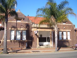
Hornsby is a suburb on the Upper North Shore of Sydney in the state of New South Wales, Australia, approximately 23 kilometres (14 mi) north-west of the Sydney central business district. It is the administrative centre of the local government area of Hornsby Shire.

<span class="mw-page-title-main">Ryde, New South Wales</span> Suburb of Sydney, New South Wales, Australia

Ryde is a suburb of Sydney, New South Wales, Australia. Ryde is located 13 km north-west of the Sydney central business district and 8 km east of Parramatta. Ryde is the administrative centre of the local government area of the City of Ryde and part of the Northern Sydney region. It lies on the north bank of the Parramatta River. People from Ryde are colloquially known as Ryders, Rydiens or Rydemen.

<span class="mw-page-title-main">North Shore (Sydney)</span> Region in New South Wales, Australia

The North Shore is a region within Northern Sydney, in the state of New South Wales, Australia, generally referring to suburbs located on the northern side of Sydney Harbour up to Wahroonga, and suburbs between Middle Harbour and the Lane Cove River.

<span class="mw-page-title-main">Hornsby Shire</span> Local government area in New South Wales, Australia

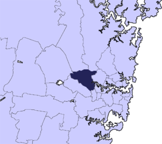
Hornsby Shire is a local government area situated in Northern Sydney, as well as parts of the Hills District, in the state of New South Wales, Australia. The shire stretches from the M2 Hills Motorway in the south to the Hawkesbury River town of Wisemans Ferry, some 53 kilometres (33 mi) to the north, making it the largest local government council in the Greater Sydney Metropolitan region by total area. As of the 2016 census the shire had an estimated population of 142,667.

<span class="mw-page-title-main">North Epping, New South Wales</span> Suburb of Sydney, New South Wales, Australia

North Epping is a suburb of Sydney, in the state of New South Wales, Australia 19 kilometres north-west of the Sydney central business district in the local government area of Hornsby Shire. North Epping is in the Northern Sydney region, and is often referred to as part of the "North-West" or North Shore. Epping is a separate suburb to the south and under the Parramatta City Council, which shares the postcode of 2121.

<span class="mw-page-title-main">Eastwood, New South Wales</span> Suburb of Sydney, New South Wales, Australia

Eastwood is a suburb of Sydney, Australia. Eastwood is located 17 kilometres north-west of the Sydney central business district in the local government areas of the City of Ryde and the City of Parramatta. Eastwood is in the Western Sydney region. The area is best known for being an ethnic enclave for immigrant populations in Sydney, mainly of East Asian origin but the suburb also has a significant number of other immigrant populations. Eastwood was originally its own town but due to the expansion of Sydney, was eventually absorbed.

<span class="mw-page-title-main">Pennant Hills, New South Wales</span> Suburb of Sydney, New South Wales, Australia

Pennant Hills is a suburb in the Northern Sydney region of Sydney, New South Wales, Australia. Pennant Hills is located 18 kilometres north-west of the Sydney central business district in the local government area of Hornsby Shire. West Pennant Hills is a separate suburb to the west of Pennant Hills and is part of the Hills District with a separate postcode.

<span class="mw-page-title-main">Beecroft, New South Wales</span> Suburb of Sydney, New South Wales, Australia

Beecroft is a suburb in the Northern Sydney region of Sydney, in the state of New South Wales, Australia 22 kilometres north-west of the Sydney central business district in the local government areas of Hornsby Shire and City of Parramatta.

<span class="mw-page-title-main">Galston, New South Wales</span> Suburb of Sydney, New South Wales, Australia

Galston is a semi-rural town located in the Hornsby District of Sydney, in the state of New South Wales, Australia. Galston is located from the city at 36 kilometres north-west of the Sydney central business district, in the local government area of the Hornsby Shire. Galston is in the NSW state electoral district of Hornsby and Federal division of Berowra. Galston is situated 16 minutes away from the suburb of Hornsby.

<span class="mw-page-title-main">Parramatta railway station</span> Railway station in Sydney, New South Wales, Australia

Parramatta railway station is a heritage-listed railway station located on the Main Western line, serving Parramatta in New South Wales, Australia. It is served by Sydney Trains T1 Western Line, T2 Inner West & Leppington and T5 Cumberland Line services and NSW TrainLink Blue Mountains Line, Central West XPT and Outback Xplorer services.

<span class="mw-page-title-main">City of Parramatta</span> Local government area in New South Wales, Australia

The City of Parramatta, also known as Parramatta Council, is a local government area located to the west and north-west of Sydney CBD in the Greater Western Sydney region. Parramatta Council is situated between the City of Ryde and Cumberland, where the Cumberland Plain meets the Hornsby Plateau, approximately 25 kilometres (16 mi) west of the Sydney central business district, in New South Wales, Australia. The city occupies an area of 84 square kilometres (32 sq mi) spanning across suburbs in Greater Western Sydney including the Hills District, and a small section of Northern Sydney to the far north east of its area. According to the 2016 census, City of Parramatta had an estimated population of 226,149. The city houses the Parramatta central business district which is one of the key suburban employment destinations for the region of Greater Western Sydney.

<span class="mw-page-title-main">Meadowbank, New South Wales</span> Suburb of Sydney, New South Wales, Australia

Meadowbank is a suburb of Sydney, New South Wales, Australia, 15 kilometres north west of the Sydney central business district, in the local government area of the City of Ryde and part of the Northern Sydney region. Meadowbank sits in a valley on the northern bank of the Parramatta River.

<span class="mw-page-title-main">Northern Sydney</span> Region of Sydney in New South Wales, Australia

Northern Sydney is a large metropolitan area in Greater Sydney, New South Wales, Australia on the north shore of Sydney Harbour and Parramatta River. The region embraces suburbs in Sydney's north-east, north and inner north west. Northern Sydney is divided into distinctive regions such as the North Shore, Northern Beaches and Forest District.

<span class="mw-page-title-main">Regions of Sydney</span> Overview article

The metropolis of Greater Sydney in New South Wales, Australia, is informally subdivided into a number of geographic regions. The geographical definition of Greater Sydney spans across 33 local government areas and includes the Blue Mountains in the west, the Northern Beaches and the Hawkesbury in the north, the Royal National Park, the Wollondilly and Macarthur in the south, and Botany Bay in the east. These areas sometimes, but not always, roughly coincide with official boundaries of suburbs, local government authorities, or cadastral units, and some of the customary regions do not have well defined boundaries at all. Some commonly referred to regions overlap: for example, Canterbury-Bankstown is often referred to as a region, but it is also part of the South Western Sydney region. The regions themselves are not used as a formal jurisdiction, and generally do not have administrative or legislative bodies, although some regions are coterminous with a local government area, and in a number of regions that include multiple local government areas, Regional Organisations of Councils have been established that represent the councils in the region.

<span class="mw-page-title-main">Metrobus (Sydney)</span> Sydney high frequency, high capacity bus network

Metrobus is a high frequency, high capacity bus network in Sydney, Australia, first introduced in 2008. Metrobus services run every 10 minutes during peak periods, 15 minutes during off-peak weekday periods, and 20 minutes on weekends, linking key commercial suburbs and centres throughout the city, with the intention of making timetables obsolete. All buses were initially painted in a distinctive red livery but recently, the standard Transport for NSW livery of blue and white has been adopted. All Metrobus services are wheelchair accessible. All route numbers were prefixed with an "M" followed by a two-digit number.

Lord Livingstone "Livie" Ramsay was an Australian architect active in the first quarter of the 20th century. He was known professionally as L L Ramsay. His work encompassed the styles of the Federation Bungalow in domestic design and Federation Free Classical in civic and commercial design. He was active in local government and was President of Hornsby Shire.

The Cumberland Free Press was a short-lived weekly Australian newspaper published and printed in Parramatta, New South Wales, with a coverage extending across the Inner West, Western and North West regions of Sydney. The paper was first published on 22 June 1895 and ceased publication in March 1898.

Terrys Creek, an urban watercourse that is part of the Lane Cove River catchment, is located in Northern Suburbs region of Sydney, Australia. It was named after Edward Terry who served as the first mayor of Eastwood municipality.

References

  1. 1 2 3 4 5 6 7 Australian Bureau of Statistics (28 June 2022). "Epping (NSW) - Suburbs and Localities". 2021 Census QuickStats. Retrieved 18 May 2023. OOjs UI icon edit-ltr-progressive.svg
  2. "Department of Health | Northern Sydney PHN Profile".
  3. https://education.nsw.gov.au/public-schools/going-to-a-public-school/finding-a-public-school#Metropolitan1%5B%5D
  4. Smith, Keith Vincent (2005). Wallumedegal : an Aboriginal history of Ryde. North Ryde, N.S.W.: Community Services Unit, City of Ryde. ISBN   9780959941999.
  5. "Epping Station". www.nswrail.net. Retrieved 29 September 2016.
  6. Compiled by Frances Pollon, ed. (1990). The Book of Sydney Suburbs. Angus & Robertson Publishers, Published in Australia. p. 100. ISBN   0-207-14495-8.
  7. Phoenix Auctions History. "Post Office List" . Retrieved 23 January 2021.
  8. Jervis, James (1961). The Cradle City of Australia: A History of Parramatta, 1788-1961. Parramatta, NSW, Australia: Council of the City of Parramatta. p. 211.
  9. Rowland, Joan (2008). "Epping". Dictionary of Sydney. Dictionary of Sydney Trust. Retrieved 27 March 2021.
  10. Walters, Rosaline (18 December 2015). "Parramatta Council scoops up Epping and Carlingford". Northern District Times. Retrieved 5 April 2017.
  11. Stevens, Kylie (12 May 2016). "Council mergers announced". Parramatta Sun. Retrieved 5 April 2017.
  12. "Epping Town Centre". Department of Planning & Environment, State Government of New South Wales. Archived from the original on 1 February 2016. Retrieved 9 December 2015.
  13. Bastians, Kate (2 April 2014). "High hopes were dashed". Northern District Times.
  14. Hutchinson, Samantha (17 September 2015). "Grocon ramps up with $56 million office block site in Epping, Sydney". The Australian. Retrieved 9 December 2015.
  15. Chancellor, Jonathan (8 February 2016). "Grocon sells Epping site to Chinese developer, Zhengtang". www.propertyobserver.com.au. Retrieved 16 December 2016.
  16. "Sydney Oxford Central development reaches completion". The Asean Developer. 22 November 2019.
  17. "Oxford Central". Ceerose. Retrieved 21 February 2020.
  18. "North-West Rail Link". Transport NSW. Retrieved 3 April 2014.
  19. "Epping Aquatic and Leisure Centre web site". hornsby.nsw.gov.au. Retrieved 15 April 2014.
  20. "Epping Library Transferring to Parramatta Council". Hornsby Shire Council. 11 October 2016.
  21. "Hornsby Shire Library & Information Service". Hornsby Shire Council. Retrieved 13 June 2014.
  22. "West Epping Community Centre web site". hornsby.nsw.gov.au. Archived from the original on 16 April 2014. Retrieved 15 April 2014.
  23. "Epping Community Centre web site". hornsby.nsw.gov.au. Archived from the original on 23 June 2014. Retrieved 15 April 2014.
  24. "Epping". The Cumberland Argus and Fruitgrowers' Advocate . Parramatta, NSW. 24 February 1906. p. 10. Retrieved 25 September 2012 via National Library of Australia.
  25. "EPPING". The Cumberland Argus and Fruitgrowers' Advocate . Parramatta, NSW. 5 August 1916. p. 8. Retrieved 25 September 2012 via National Library of Australia.
  26. Epping Community Centre Archived 6 June 2013 at the Wayback Machine . Retrieved 25 September 2012.
  27. "Epping Leisure and Learning Centre". hornsby.nsw.gov.au. Archived from the original on 16 April 2014. Retrieved 15 April 2014.
  28. "Epping Creative Centre". hornsby.nsw.gov.au. Archived from the original on 16 April 2014. Retrieved 15 April 2014.
  29. "Epping YMCA" . Retrieved 15 April 2014.
  30. "Boronia Park". Archived from the original on 22 June 2014. Retrieved 13 April 2014.
  31. "David Scott Reserve". Archived from the original on 22 June 2014. Retrieved 13 April 2014.
  32. "Duncan Park". Archived from the original on 22 June 2014. Retrieved 13 April 2014.
  33. "Epping Athletic Track" . Retrieved 13 April 2014.
  34. "Epping Oval" . Retrieved 13 April 2014.
  35. "Epping Oval Playground" . Retrieved 13 April 2014.
  36. "Forest Park" . Retrieved 13 April 2014.
  37. "Grant Close Netball Courts" . Retrieved 13 April 2014.
  38. Narelle Underwood – Chair, Geographical Names Board (11 August 2017). "GEOGRAPHICAL NAMES ACT 1966". NSW Government Gazette (87).
  39. "Kim Rutherford Reserve". Archived from the original on 22 June 2014. Retrieved 13 April 2014.
  40. "Loftus Square". Archived from the original on 22 June 2014. Retrieved 13 April 2014.
  41. "North Epping Oval" . Retrieved 13 April 2014.
  42. "Pembroke Street Park" . Retrieved 13 April 2014.
  43. "Ron Payne Park" . Retrieved 13 April 2014.
  44. "Somerville Oval" . Retrieved 13 April 2014.
  45. "West Epping Oval" . Retrieved 13 April 2014.
  46. "Life Way the new name for Epping Lutheran Church". Community News, published by Greg Smith SC MP, member for Epping. April 2014.
  47. "Home - Epping West Public School".
  48. "Contact Us" American International School of Sydney. 1 April 2001. Retrieved on 15 September 2015.
  49. Australian Bureau of Statistics (9 March 2006). "Epping (State Suburb) 2001". 2001 Census QuickStats. Retrieved 8 April 2014. OOjs UI icon edit-ltr-progressive.svg
  50. "City of Parramatta Council: The merger of Parramatta City, The Hills Shire, Auburn City, Holroyd City and Hornsby Shire councils". New South Wales Government. 2016. Archived from the original on 10 June 2016. Retrieved 7 June 2016.

33°46′29″S151°04′44″E / 33.7746°S 151.0788°E / -33.7746; 151.0788