Camellia, New South Wales

Last updated

Camellia
Sydney,  New South Wales
Rosehill Camellia, w silverwater.jpg
Aerial view of Camellia
Camellia, New South Wales
Map
Population0 (SAL 2021) [1]
Postcode(s) 2142
Elevation9 m (30 ft)
Location17 km (11 mi) west of Sydney CBD
LGA(s) City of Parramatta
State electorate(s) Parramatta
Federal division(s) Parramatta
Suburbs around Camellia:
Parramatta Rydalmere Rydalmere
Parramatta Camellia Silverwater
Harris Park Rosehill Silverwater

Camellia is a suburb of Sydney, in the state of New South Wales, Australia. Primarily industrial with no residential population, environmental remediation commenced in late 2015, with the suburb ear-marked as a major centre for future high density living. [2]

Contents

Camellia is located 17 kilometres (11 mi) west of the Sydney central business district in the local government area of the City of Parramatta. The suburb is bounded by the Parramatta River to the north, Clay Cliff Creek to the west, Duck River to the east, and Grand Avenue. Major roads dissecting the suburb are Grand Avenue (east-west) and James Ruse Drive (north-south).

Camellia shares the postcode of 2142 with the separate suburbs of Granville, South Granville, Holroyd and Rosehill.

History

The Burramattagal clan were the indigenous people who originally inhabited this area, relying on the fish, shellfish, bird life reptiles and marsupials that were once abundant in the waterways and forests adjoining the Parramatta River and the freshwaters of Clay Cliff Creek.

On 22 April 1788 Governor Arthur Phillip and his party of officers and marines journeyed inland by boat from Sydney Cove to find better farmlands for the new settlement. They landed at the head of a navigable river near what is now Clyde, which he called Duck River due to the abundance of ducks in the area. [3] They left their boats to explore the area but could not penetrate the thick bush. The party moved to the banks of Clay Cliff Creek, where they decided to camp because of its fresh water. [4]

Romanticised painting of Elizabeth Farm viewed from the northern riverbank of Parramatta River by Joseph Lycett. The freshwater stream depicted in the middle as a tributary is Clay Cliff Creek. Joseph Lycett - Residence of John Macarthur Esq near Parramatta N.S.W. - Google Art Project.jpg
Romanticised painting of Elizabeth Farm viewed from the northern riverbank of Parramatta River by Joseph Lycett. The freshwater stream depicted in the middle as a tributary is Clay Cliff Creek.

In his Journal, surgeon John White recorded:

...we fell in with an hitherto unperceived branch of Port Jackson harbour, along the bank of which the grass was tolerably rich and succulent, and in height nearly up to the middle, interspersed with a plant much resembling the indigo. We followed this branch westward for a few miles, until we came to a small fresh-water stream that emptied itself into it. Here we took up our quarters for the night, as our halts were always regulated by fresh water, an essential point by no means to be dispensed with, and not very abundant or frequently to be met with, in this country. We made a kettle of excellent soup out of a white cockatoo and two crows, which I had shot, as we came along. The land all around us was similar to that which we had passed.

Clay Cliff Creek was the common boundary of the land grants to wool pioneer John Macarthur, who by the early 1800s extended his land grants and his Elizabeth Farm holdings to gain the complete river frontage between the township of Parramatta and Duck River. [4]

The railway station that opened here in 1885 was originally called Subiaco, but it caused confusion because this was the name of the Benedictine school on the opposite side of Parramatta River. In 1901, the station name was changed to Camellia, after the Camellia Grove Nursery nearby that specialised in growing camellias. This land was leased by Silas Sheather since 1852 on what was originally part of the 850 acres (3.4 km2) of Elizabeth Farm. [5]

Heritage listings

Camellia has a number of heritage-listed sites, including:

In the northwest of Camellia, today within an inaccessible industrial zone, lies the lone grave of First Fleet convict Eleanor Magee (née McCabe), her child Ian Magee, and her unborn baby. The three drowned in the adjacent Parramatta River when their boat capsized in 1793, and they were buried on what was then the land of convict Christopher Magee, their husband and father. It is one of the oldest European graves in Australia. [7]

Commercial area

Camellia is predominantly an industrial and commercial area. An office block close to the railway station contains an Aldi supermarket. This is the former site of the James Hardie asbestos plant where Bernie Banton worked.

Transport

Camellia railway station on the Carlingford Line was formerly part of the Sydney Trains network.

The Sandown railway line served the industry in Camellia. [8] Passenger service ceased in 1991. [9]

A conversion of the Carlingford to Camellia section of the Carlingford railway line as well as part of the Sandown line to light rail was announced in 2015 as part of the Parramatta Light Rail project. [10] A second line, from Sydney Olympic Park, will join with the Carlingford line at either Camellia or Rydalmere before both lines proceed to Westmead. [11] [12]

Grand Avenue is the main road in Camellia.

Related Research Articles

<span class="mw-page-title-main">Carlingford, New South Wales</span> Suburb of Sydney, New South Wales, Australia

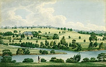
Carlingford is a suburb of Sydney, in the state of New South Wales, Australia. Carlingford is 22 kilometres north-west of the Sydney central business district in the local government area of City of Parramatta. Carlingford is in the Hills District and Northern Sydney regions.

<span class="mw-page-title-main">Westmead, New South Wales</span> Suburb of Sydney, New South Wales, Australia

Westmead is a suburb in Sydney, in the state of New South Wales, Australia. Westmead is located 26 kilometres west of the Sydney central business district in the local government area of Cumberland Council and is part of the Greater Western Sydney region.

Dundas is a suburb of Sydney, New South Wales, Australia. Dundas is located 21 kilometres north-west of the Sydney central business district, in the local government area of the City of Parramatta, and the electoral division of Bennelong. Dundas is a leafy green suburb, notably due to its centrepiece The Ponds Walk, which follows the Ponds Subiaco Creek. Dundas is part of the Northern Sydney and Greater Western Sydney regions.

<span class="mw-page-title-main">Dundas railway station, Sydney</span> Former railway station in Sydney, New South Wales, Australia

Dundas railway station, originally Kissing Point Road railway station, is a heritage-listed former railway station in Sydney, Australia, that was open between 1896 and 2020 and was located on the Carlingford line, serving the suburb of Dundas.

<span class="mw-page-title-main">Rosehill railway station</span> Former railway station in Sydney, Australia

Rosehill railway station is a disused railway station in Sydney, Australia that is located next to Rosehill Gardens Racecourse. It was open between 1888 and 2020. It served passengers on the Sandown railway line until 1991, the Carlingford line until 2020, and special event services to the racecourse, as well as serving the local suburb of Rosehill.

<span class="mw-page-title-main">Rydalmere, New South Wales</span> Suburb of Sydney, New South Wales, Australia

Rydalmere(formerly "Field of Mars") is a suburb of Sydney, in the state of New South Wales, Australia. Rydalmere is approximately 21 kilometres west of the Sydney central business district in the local government area of the City of Parramatta. Rydalmere is part of the Greater Western Sydney region.

<span class="mw-page-title-main">Carlingford railway station</span> Former railway station in Sydney, New South Wales, Australia

Carlingford railway station was a railway station in Sydney, Australia. It opened in 1896 and was the terminus of the Carlingford line, which served the suburb of Carlingford and was served by Sydney Trains T6 Carlingford line services. The Carlingford railway line was closed on 5 January 2020 with the station demolished in May 2020.

<span class="mw-page-title-main">Lidcombe railway station</span> Railway station in Sydney, New South Wales, Australia

Lidcombe railway station is located on the Main Suburban line, serving the Sydney suburb of Lidcombe. It is served by Sydney Trains T1 Western, T2 Inner West & Leppington, T3 Bankstown and T7 Olympic line services.

<span class="mw-page-title-main">Camellia railway station</span> Former railway station in Sydney, Australia

Camellia railway station, originally Subiaco railway station, was a railway station in Sydney, Australia, that was open between 1885 and 2020. It was located on the Carlingford line, serving the suburb of Camellia and at the time of closure was served by Sydney Trains T6 Carlingford line services.

<span class="mw-page-title-main">Rydalmere railway station</span> Former railway station in Sydney, Australia

Rydalmere railway station, originally Victoria Road railway station, was a railway station in Sydney, Australia that was open between 1896 and 2020. It was located on the Carlingford line and served the suburb of Rydalmere. At the time of closure, Rydalmere station was served by Sydney Trains T6 Carlingford line services.

<span class="mw-page-title-main">Telopea railway station</span> Former railway station in Sydney, New South Wales, Australia

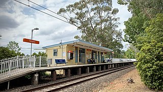
Telopea railway station was a railway station in Sydney, Australia, that was opened in 1925. It is located on the Carlingford line, and served the suburb of Telopea. It was served by Sydney Trains T6 Carlingford line services. The Carlingford railway line closed on 5 January 2020, and the station was demolished in May of that year

<span class="mw-page-title-main">Telopea, New South Wales</span> Suburb of Sydney, New South Wales, Australia

Telopea is a suburb of Greater Western Sydney, in the state of New South Wales, Australia. Telopea is located 23 kilometres north-west of the Sydney central business district, in the local government area of the City of Parramatta. The suburb is bordered by Kissing Point Road to the south and Pennant Hills Road to the north.

<span class="mw-page-title-main">Clyde, New South Wales</span> Suburb of Sydney, New South Wales, Australia

Clyde is a locality of Sydney, in the state of New South Wales, Australia. Clyde is located 21 kilometres west of the Sydney central business district in the local government area of the City of Parramatta. Clyde is part of the Greater Western Sydney region.

<span class="mw-page-title-main">Clyde railway station, Sydney</span> Railway station in Sydney, New South Wales, Australia

Clyde railway station is located on the Main Suburban line, serving the Sydney suburb of Clyde. It is served by Sydney Trains T1 Western and T2 Inner West & Leppington line services.

<span class="mw-page-title-main">Railways in Sydney</span>

Sydney, the largest city in Australia, has an extensive network of passenger and freight railways. The passenger system includes an extensive suburban railway network, operated by Sydney Trains, a metro network and a light rail network. A dedicated freight network also exists. Future expansion of the light rail network includes the Parramatta Light Rail. Existing light rail services are the Inner West Light Rail and the CBD & South East Light Rail.

<span class="mw-page-title-main">Sandown railway line</span> Defunct railway line in Sydney

The Sandown Line is a short former industrial railway line in the western suburbs of Sydney, New South Wales, Australia. It began life as the Bennett's Railway, opening on 17 November 1888. The line diverges from the Carlingford line just south of Camellia station.

<span class="mw-page-title-main">Duck River (New South Wales)</span> River in New South Wales, Australia

The Duck River is a perennial stream and southern tributary of the Parramatta River, in Sydney, New South Wales, Australia.

<span class="mw-page-title-main">Sydney Trains</span> Operator of passenger rail services in metropolitan Sydney

Sydney Trains is the operator of the suburban passenger rail network serving the city of Sydney, New South Wales, Australia. The network is a hybrid urban-suburban rail system with a central underground core that covers 369 km (229 mi) of route length over 813 km (505 mi) of track, with 170 stations on eight lines.

<span class="mw-page-title-main">Carlingford railway line</span> Former railway line in Sydney, New South Wales, Australia

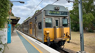
The Carlingford railway line was a railway line in Sydney, Australia. It was opened from Clyde to Subiaco in January 1885, then by means of the construction of a bridge across the Parramatta River, to Carlingford in April 1896. It closed on 5 January 2020 with much of the line to be converted to light rail as part of the Parramatta Light Rail network, while a short section of the line was retained for use by Sydney Trains.

<span class="mw-page-title-main">Parramatta Light Rail</span> Light rail line under construction in Sydney

The Parramatta Light Rail is a project for a twelve-kilometre (seven-mile) light rail line in Sydney, New South Wales, Australia, which is under construction and due to start passenger services in May 2024. The line will run from Westmead to Carlingford via the Western Sydney centre of Parramatta. The initial announcement of the project also included an eastern branch from Camellia to Strathfield. Plans to construct this branch were deferred in February 2017, and in October the original plans were replaced with a redesigned and truncated route to Sydney Olympic Park. The project will add to light rail in Sydney but the new line will be completely separated from the existing lines. It is being managed by Transport for NSW.

References

  1. Australian Bureau of Statistics (28 June 2022). "Camellia (Suburb and Locality)". Australian Census 2021 QuickStats. Retrieved 28 June 2022.  OOjs UI icon edit-ltr-progressive.svg
  2. "Camellia".
  3. "Plants – Duck River". Duck River Sydney Biodiversity. Archived from the original on 20 December 2013. Retrieved 25 October 2012.
  4. 1 2 McClymont, John (June 2009). "Camellia". Sydney Journal. 2 (1): 82–91. doi: 10.5130/sj.v2i1.1191 . ISSN   1835-0151 . Retrieved 9 July 2013.
  5. The Book of Sydney Suburbs, Compiled by Frances Pollen, Angus & Robertson Publishers, 1990, Published in Australia ISBN   0-207-14495-8
  6. "Sewage Pumping Station 67". New South Wales State Heritage Register . Department of Planning and Environment. H01643. Retrieved 18 May 2018. CC-BY icon.svg Text is licensed by State of New South Wales (Department of Planning and Environment) under CC-BY 4.0 licence .
  7. "Eleanor McCabe | Parramatta History and Heritage". historyandheritage.cityofparramatta.nsw.gov.au. Retrieved 9 January 2023.
  8. John McClymont. "Camellia". dictionaryofsydney.org. Retrieved 26 March 2020.
  9. "Cityrail launches new timetable". Railway Digest (February 1992): 45. 1992.
  10. "Parramatta Light Rail – How the preferred network was chosen". Transport for NSW. Archived from the original on 10 December 2015. Retrieved 8 December 2015.
  11. "Parramatta Light Rail to Sydney Olympic Park". Transport for NSW. 18 October 2017. Retrieved 18 October 2017.
  12. Constance, Andrew. "We're planning light rail extension to Sydney Olympic Park to improve public transport for 1000's[sic] of event goers" . Retrieved 19 October 2017 via Twitter.

Coordinates: 33°49′15″S151°1′33″E / 33.82083°S 151.02583°E / -33.82083; 151.02583