The Parramatta River is an intermediate tide-dominated, drowned valley estuary located in Sydney, New South Wales, Australia. With an average depth of 5.1 metres (17 ft), the Parramatta River is the main tributary of Sydney Harbour, a branch of Port Jackson. Secondary tributaries include the smaller Lane Cove and Duck rivers.

The Inner West of Sydney is an area directly west of the Sydney central business district, New South Wales, Australia. The suburbs that make up the Inner West are predominantly located along the southern shore of Port Jackson, stretching south to the shores of the Cooks River. The western boundary of the Inner West is approximately the A3 arterial road, which divides the Inner West from the Greater Western Sydney region. The Inner West is much larger than the Inner West Council local government area. The Inner West roughly corresponds with the Parish of Petersham and Parish of Concord, two cadastral divisions used for land titles.

Canada Bay is a suburb in the Inner West of Sydney, in the state of New South Wales, Australia. It is 11 kilometres (6.8 mi) west of the Sydney central business district, in the local government area of City of Canada Bay.

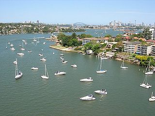
Canada Bay is an estuarine bay on the Parramatta River, in the inner-west of Sydney, in the state of New South Wales, Australia. It is the innermost inlet of the larger Hen and Chicken Bay. Two other bays to the north of Canada Bay are two other bays named for Canadian internment camps for convicts involved in the Lower Canada Rebellion:
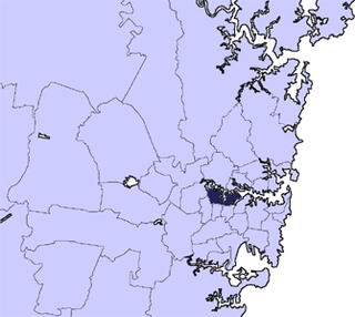
The City of Canada Bay is a local government area in the Inner West region of Sydney, New South Wales, Australia. The city was formed on 1 December 2000, following the merger of Concord and Drummoyne councils. The city covers an area of 19.82 square kilometres (7.65 sq mi) and as at the 2021 census had a resident population of 89,177. The city is ultimately named after Canada Bay, a bay and suburb along the Parramatta River.

Five Dock is a suburb in the Inner West of Sydney, in the state of New South Wales, Australia. Five Dock is located 10 kilometres west of the Sydney central business district, in the local government area of the City of Canada Bay.

The Division of Lowe was an Australian Electoral Division in the state of New South Wales. It was located in the inner western suburbs of Sydney, on the south shore of the Parramatta River. It included the suburbs of Drummoyne, Five Dock, Croydon, Croydon Park, Burwood, Enfield, Homebush, Strathfield, Concord, Rhodes, Canada Bay, Cabarita, Abbotsford and Mortlake.

The Division of Reid is an Australian electoral division in the state of New South Wales.
Russell Lea is a small suburb in the inner-west of Sydney, in the state of New South Wales, Australia. Russell Lea is located 8 kilometres west of the Sydney central business district in the local government area of the City of Canada Bay.

Rodd Point is a suburb in the Inner West of Sydney, in the state of New South Wales, Australia. It is 9 kilometres west of the Sydney central business district in the local government area of the City of Canada Bay.

Wareemba is a suburb in the Inner West of Sydney in the state of New South Wales, Australia. Wareemba is 12 kilometres west of the Sydney central business district in the local government area of the City of Canada Bay. Wareemba sits on the eastern shore of Hen and Chicken Bay, on the Parramatta River. It is almost the smallest suburb in Sydney by land area.

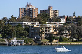
Drummoyne is a suburb in the Inner West of Sydney, in the state of New South Wales, Australia. Drummoyne is six kilometres west of the Sydney central business district and is the administrative centre for the local government area of the City of Canada Bay.

Breakfast Point is a suburb in the Inner West of Sydney, in the state of New South Wales, Australia. Breakfast Point is located 16 kilometres west of the Sydney central business district. It is in the local government area of the City of Canada Bay. People from Breakfast Point are colloquially called Prandium Indicatus.
Chiswick is a suburb in the Inner West of Sydney, in the state of New South Wales, Australia. It is located 9 kilometres west of the Sydney central business district in the local government area of the City of Canada Bay. Chiswick sits on the peninsula between Abbotsford Bay and Five Dock Bay, on the Parramatta River. It is surrounded by the suburbs of Abbotsford, Russell Lea and Drummoyne.

Concord West is a suburb in Sydney's inner-west, in the state of New South Wales, Australia. Concord West is located 16 km west of the Sydney central business district, in the local government area of the City of Canada Bay. Concord is a separate suburb, to the east.

The Iron Cove Bridge is a heritage-listed road bridge that carries Victoria Road (A40) across Iron Cove, between the Sydney suburbs of Drummoyne and Rozelle. Iron Cove is an arm of Sydney Harbour.

Parramatta River ferry services connect suburbs along the Parramatta River in Sydney with Circular Quay by commuter ferry. The services are numbered F3 and form part of the Sydney Ferries network.

Concord Parish is one of the 57 parishes of Cumberland County, New South Wales, a cadastral unit for use on land titles. It is located to the south of the Parramatta River between Homebush Bay and Iron Cove; and to the north of Cooks River. It includes the suburbs of Homebush, most of Strathfield, Burwood, Croydon, Concord, Canada Bay, Abbotsford and Drummoyne. It covers the local government areas of City of Canada Bay and the Municipality of Burwood and most of the Municipality of Strathfield. It roughly corresponds to the western half of the Inner West region, with the neighbouring Parish of Petersham making up the eastern half.

Drummoyne Oval is a multi-use sports ground in the Sydney inner-west suburb of Drummoyne, New South Wales. The ground has been used for international women's cricket matches, domestic men's cricket matches and first grade rugby league as well as local Australian rules football and Rugby Union games.

The Bay Run is a 7-kilometre-long pedestrian and cycling circuit around Iron Cove passing through the suburbs of Rozelle, Lilyfield, Haberfield, Five Dock, Rodd Point. Russell Lea and Drummoyne. in the Inner West of Sydney, New South Wales, Australia. The Bay Run provides excellent views of Iron Cove for its entire course as it constantly hugs the shoreline. The Bay Run is popular with joggers, walkers, roller skaters and cyclists who enjoy the pleasant waterside scenery while exercising. The Bay Run plays host to the annual Bay Run fun run, a community event that brings people together in the name of health, fun and exercise.

