New England Tablelands bioregion

Last updated

New England Tablelands
Point Lookout, New England.jpg
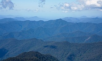
View west over the New England Tablelands from Point Lookout.
IBRA 6.1 New England Tablelands.png
The interim Australian bioregions,
with New England Tablelands in red.
Country Australia
State Australia
Area
[1]
  Total
30,022 km2 (11,592 sq mi)
Elevation
[2]
600–1,500 m (2,000–4,900 ft)
Mean max temp9–17 °C (48–63 °F) [3]
Mean min temp−3.6–6 °C (25.5–42.8 °F) [3]
Annual rainfall653–1,765 mm (25.7–69.5 in) [3]
Regions around New England Tablelands
Nandewar Nandewar New South Wales North Coast
Nandewar New England Tablelands New South Wales North Coast
Nandewar Nandewar New South Wales North Coast

New England Tablelands (code NET), an interim Australian bioregion, is located mainly in New South Wales, [4] [5] comprising 3,002,213 hectares (7,418,630 acres), [1] of which 2,860,758 hectares (7,069,090 acres) or 95.23 per cent of the bioregion lies within New South Wales; and the residual within Queensland. This bioregion is one of the smaller bioregions in NSW, occupying 3.57 per cent of the state. [6]

Contents

The New England Tableland Bioregion is a stepped plateau of hills and plains with elevations between 600 and 1,500 metres (2,000 and 4,900 ft) on Permian sedimentary rocks, intrusive granites and extensive Tertiary basalts. [2] Rainfall varies considerably from 653 to 1,765 millimetres (25.7 to 69.5 in) [3] and mean temperatures range from −3 to 17 °C (27 to 63 °F), [3] based on changes with topography. In terms of plants, the region is dominated by stringy bark/box/peppermint species, including Eucalyptus caliginosa , E. nova-anglica , E. melliodora and E. blakelyi . [7]

Subregions

In the IBRA system it has the code of (NET), and it has nineteen sub-regions:

IBRA regions and subregions: IBRA7
IBRA subregionIBRA
code
Area
ha acres
Bundarra Downs NET01151,867375,270
Beardy River Hills NET0224,62560,850
Walcha Plateau NET03473,8251,170,850
Armidale Plateau NET04290,577718,030
Wongwibinda Plateau NET05106,929264,230
Deepwater Downs NET0697,773241,600
Glenn Innes-Guyra Basalts NET07277,299685,220
Ebor Basalts NET0835,70988,240
Moredun Volcanics NET09117,461290,250
Severn River Volcanics NET10150,795372,620
Northeast Forest Lands NET11206,492510,250
Tenterfield Plateau NET12139,242344,070
Yarrowyck-Kentucky Downs NET1365,135160,950
Binghi Plateau NET1464,555159,520
Stanthorpe Plateau NET15267,999662,240
Eastern Nandewars NET16319,096788,500
Tingha Plateau NET1778,461193,880
Nightcap NET18113,767281,120
Round Mountain NET1920,60650,920

References

  1. 1 2 "Interim Biogeographic Regionalisation for Australia (IBRA7) regions and codes". Department of Sustainability, Environment, Water, Population and Communities. Commonwealth of Australia. 2012. Retrieved 13 January 2013.
  2. 1 2 "New England Tableland - landform". Office of Environment & Heritage. Government of New South Wales. 26 April 2016. Retrieved 25 March 2018.
  3. 1 2 3 4 5 "New England Tableland - climate". Office of Environment & Heritage. Government of New South Wales. 26 April 2016. Retrieved 25 March 2018.
  4. Environment Australia. "Revision of the Interim Biogeographic Regionalisation for Australia (IBRA) and Development of Version 5.1 - Summary Report". Department of the Environment and Water Resources, Australian Government. Archived from the original on 5 September 2006. Retrieved 31 January 2007.
  5. IBRA Version 6.1 data
  6. "New England Tableland Bioregion". Office of Environment & Heritage. Government of New South Wales. 26 April 2016. Retrieved 25 March 2018.
  7. Environment Australia. "Revision of the Interim Biogeographic Regionalisation for Australia (IBRA) and Development of Version 5.1 - Summary Report". Department of the Environment and Water Resources, Australian Government. Archived from the original on 4 September 2006. Retrieved 6 May 2018.{{cite journal}}: Cite journal requires |journal= (help)

Further reading

See also