Broken Hill Complex | |||||||||||||
|---|---|---|---|---|---|---|---|---|---|---|---|---|---|
 The interim Australian bioregions, with the Broken Hill Complex in red | |||||||||||||
| Country | Australia | ||||||||||||
| State | Australia | ||||||||||||
| Area | |||||||||||||
• Total | 56,354.22 km2 (21,758.49 sq mi) | ||||||||||||
| |||||||||||||
The Broken Hill Complex (code BHC), an interim Australian bioregion, is located in both New South Wales and South Australia, [1] and comprises an area of 5,635,422 hectares (13,925,430 acres) [2] of inland Australia.
IBRA 5.1 describes BHC as being:
Hills and colluvial fans on Proterozoic rocks; desert loams and red clays, lithosols and calcareous red earths; supporting chenopod shrublands Maireana spp. - Atriplex spp. shrublands, and mulga open shrublands Acacia aneura . [3]
| IBRA regions and subregions: IBRA7 | ||||
|---|---|---|---|---|
| IBRA region / subregion | IBRA code | Area | States | Location in Australia |
| Broken Hill Complex | BHC | 5,635,422 hectares (13,925,430 acres) | SA / NSW | 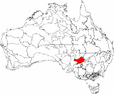 |
| Barrier Range | BHC01 | 1,802,996 ha (4,455,300 acres) | ||
| Mootwingee Downs | BHC02 | 630,694 ha (1,558,480 acres) | ||
| Scopes Range | BHC03 | 260,806 ha (644,470 acres) | ||
| Barrier Range Outwash | BHC04 | 1,954,973 ha (4,830,840 acres) | ||
| Bimbowrie | BHC05 | 279,258 ha (690,060 acres) | ||
| Curnamona | BHC06 | 706,696 ha (1,746,280 acres) | ||