Great Western Highway is a 202-kilometre-long (126 mi) state highway in New South Wales, Australia. From east to west, the highway links Sydney with Bathurst, on the state's Central Tablelands. The highway also has local road names between the Sydney city centre and Parramatta, being: Broadway from Haymarket to Chippendale, Parramatta Road from Chippendale to Parramatta, and Church Street through Parramatta.
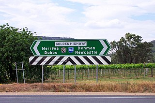
Golden Highway is a 313-kilometre (194 mi) highway, located in the Hunter and Orana regions of New South Wales, Australia. It runs eastwards from Dubbo towards Newcastle on the coast, allowing road transport to avoid travelling over the Blue Mountains to Sydney, and is designated route B84.

U.S. Route 264 (US 264) is an east–west United States Highway located completely within the U.S. state of North Carolina, running for 215.7 miles (347.1 km). Its western terminus is located at Interstate 87 (I-87), I-440, and US 64 in Raleigh. US 264 is a freeway between Raleigh and Wilson, with segments running concurrently with I-87, I-587, I-795, and US 64. The highway is largely parallel to I-587 between Wilson and Greenville and primarily serves smaller communities such as Saratoga and Farmville. East of Greenville, US 264 is an important highway connecting communities such as Washington, Belhaven, Swan Quarter, and Engelhard. The eastern terminus of US 264 is located at US 64 in Manns Harbor.

Great Eastern Highway is a 590-kilometre-long (370 mi) road that links the Western Australian capital of Perth with the city of Kalgoorlie. A key route for road vehicles accessing the eastern Wheatbelt and the Goldfields, it is the western portion of the main road link between Perth and the eastern states of Australia. The highway forms the majority of National Highway 94, although the alignment through the Perth suburbs of Guildford and Midland, and the eastern section between Coolgardie and Kalgoorlie are not included. Various segments form parts of other road routes, including National Route 1, Alternative National Route 94, and State Route 51.

Wolgan Valley is a small valley located along the Wolgan River in the Lithgow Region of New South Wales, Australia. The valley is located approximately 32 kilometres (20 mi) north of Lithgow and 150 kilometres north-west of Sydney. Accessible by the Wolgan Valley Discovery Trail from the Castlereagh Highway, the road travels through the valley leading onto the historical village of Newnes and its extensive industrial ruins.

Mississippi Highway 32 is a state highway in northern Mississippi it runs from east to west for 152.0 miles (244.6 km), serving the counties of Bolivar, Sunflower, Tallahatchie, Yalobusha, Calhoun, and Chickasaw. The publicly accessible portion of MS 32 is divided into two sections, the first of which begins near Perthshire and runs eastward to the rear entrance of the Mississippi State Penitentiary (MSP). The second section begins at the main entrance of MSP and runs eastward to MS 32's terminus in Okolona. A private portion of MS 32 runs from the main entrance of MSP to the rear entrance of MSP.

Bylong Valley Way is a New South Wales regional road linking Golden Highway near Sandy Hollow to Castlereagh Highway near Ilford. It is named after the Bylong Valley, through which the road passes.

The Bylong Valley is a winding but relatively flat valley that crosses the Great Dividing Range between the Goulburn River National Park and Wollemi National Park, west of the upper Hunter Region in New South Wales, Australia.
Bathurst-Ilford Road is a 72.0-kilometre (44.7 mi) New South Wales country road linking Ilford to the regional hub of Bathurst.

Rylstone is a small town in New South Wales, Australia, in the Central Tablelands region within the Mid-Western Regional Council local government area. It is located on the Bylong Valley Way road route. At the 2021 census, Rylstone had a population of 904.

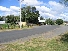
Sandy Hollow is a small rural town in New South Wales, Australia in Muswellbrook Shire. The town is located on the Golden Highway in the far west of the Upper Hunter Valley, about 260 km north of Sydney.

Baerami is a locality in the Muswellbrook Shire in the Upper Hunter region of New South Wales, Australia.

The Merriwa railway line in the Hunter Valley of northern New South Wales, Australia, branches from the Main North line at Muswellbrook and travels south west to Denman then generally north west through Sandy Hollow to Merriwa, a distance of approximately 80 kilometres (50 mi). The line opened to Denman on 26 April 1915, and to Merriwa on 29 October 1917. CPH railmotor operated passenger service ceased on 7 July 1973.

Bell is a small rural and residential village in the Blue Mountains region of New South Wales, Australia. It is the north-westernmost village in the City of Blue Mountains, located approximately 125 kilometres (78 mi) west of Sydney central business district by road or 137 kilometres (85 mi) by rail, approximately 20 kilometres (12 mi) east of Lithgow and 10 kilometres (6.2 mi) north of Mount Victoria. It is a locality on the junction of the Bells Line of Road, Chifley Road and the Darling Causeway, with an elevation of approximately 1,100 metres (3,600 ft) AHD.

Pennsylvania Route 130 (PA 130) is a 49-mile-long (79 km) state highway located in Allegheny and Westmoreland counties in Pennsylvania. The western terminus is at PA 8 in Pittsburgh, and the eastern terminus is at PA 381 near Kregar.
Bylong River, a perennial river of the Hunter River catchment, is located in the Central Tablelands and Upper Hunter regions of New South Wales, Australia.
Widden is a locality in New South Wales, Australia, in the Muswellbrook Shire. It is located on the Bylong Valley Way. The Sandy Hollow- Gulgong goods railway line passes through the locality.
Tourist Drives in Western Australia are routes through areas of scenic or historic significance, designated by route markers with white numbers on a brown shield. Tourist Drives were introduced into Western Australia while Eric Charlton was the state government Minister for Transport in the 1990s. The 28 numbered routes collectively traverse more than 2,000 kilometres (1,200 mi) across the state. In addition to the Tourist Drives, there are unnumbered routes such as the Golden Pipeline Heritage Trail, and local governments may designate and maintain local scenic drives, generally unnamed and unnumbered.
Manuwarra Red Dog Highway is a major road currently under construction in the Pilbara region of Western Australia, between Karratha and Tom Price. Originally known as Karratha–Tom Price Road, it acquired its new name in September 2020 after community consultation. Manuwarra means "'heaps' or 'masses'" in the Yindjibarndi language and is the indigenous name for the Red Dog Gorge in the Millstream Chichester National Park. Both the gorge and the highway acquired its English name from the eponymous Red Dog, a famous Kelpie/Cattle Dog and Pilbara mascot from the 1970s.
Ootann Road is a continuous 90.5 kilometres (56.2 mi) road route in the Mareeba and Tablelands local government areas of Queensland, Australia. It is a north-south link between the Burke Developmental Road and the Kennedy Highway, servicing a number of cattle grazing and production areas in northern Queensland. It is also part of the shortest route from the Chillagoe area to Hughenden.