
Mitchell Shire is a local government area in the Hume region of Victoria, Australia, located North of Melbourne. It covers an area of 2,862 square kilometres (1,105 sq mi) and, in April 2024, had a projected population of 61,362. Larger towns include Beveridge, Broadford, Kilmore, Seymour, Tallarook, Pyalong and Wallan. It was formed in 1994 from the amalgamation of the Shire of Pyalong, the Shire of Kilmore, most of the Shire of Broadford, and parts of the Shire of McIvor and Rural City of Seymour.

Murrumbidgee Shire was a local government area in the Riverina region of south western New South Wales, Australia. The Shire was located adjacent to the Murrumbidgee River and the Newell Highway.

Culcairn is a town in the south-east Murray region of New South Wales, Australia. Culcairn is located in the Greater Hume Shire local government area on the Olympic Highway between Albury and Wagga Wagga. The town is 514 kilometres (319 mi) south-west of the state capital, Sydney and at the 2016 census had a population of 1,473.

The Hume Australian Football Netball League (HFNL), often shortened to Hume Football League, is an Australian rules football and netball competition containing twelve clubs based in the South West Slopes and southern Riverina regions of New South Wales, Australia. The league features four grades in the Australian rules football competition, with these being First-Grade, Reserve-Grade, Under 17s and Under 14s. In the netball competition, there are six grades, with these being A-Grade, B-Grade, C-Grade, C-Reserve Grade, Intermediates and Juniors.

The Carrathool Shire is a local government area that borders both the Riverina and Far West regions of New South Wales, Australia. The Shire comprises 18,933 square kilometres (7,310 sq mi) and is located adjacent to the Mid-Western Highway and north of the Sturt Highway.

Lachlan Shire is a local government area in the Central West region of New South Wales, Australia. The Shire is located adjacent to the Lachlan River, the Lachlan Valley Way and the Broken Hill railway line.

Wakool Shire was a local government area in the Riverina region of New South Wales, Australia. The Shire was located between the Murray River and the Murrumbidgee River and adjacent to the Sturt Highway. Towns in the Shire are Barham, Moulamein, Tooleybuc, Wakool and Koraleigh.

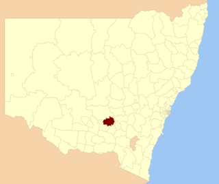
Berrigan Shire is a local government area in the southern Riverina region of New South Wales, Australia. The Shire lies on the New South Wales State border with Victoria formed by the Murray River. The Shire is adjacent to the Newell and Riverina Highways. The Shire is a mainly agricultural region, with dairying, cattle raising, woolgrowing and cropping the main activities. The vast majority of the Shire is irrigated. Tourism is another major activity, concentrated on the river towns of Tocumwal and Barooga.

Forbes Shire is a local government area in the central west region of New South Wales, Australia. The Shire was formed in 1981 from the amalgamation of the Municipality of Forbes and the Shire of Jemalong resulting from the Local Government Areas Amalgamation Act 1980.

Cootamundra Shire was a local government area in the Riverina region of New South Wales, Australia. The Shire was located adjacent to the Olympic Highway, the Burley Griffin Way and the Main South railway line. The Shire included the town of Cootamundra and the small towns of Stockinbingal, Brawlin and Wallendbeen and the locality of Frampton. The Shire was created on 1 April 1975 by the amalgamation of Jindalee Shire and the Municipality of Cootamundra.

The Junee Shire is a local government area in the Riverina region of New South Wales, Australia. The Shire comprises an area of 2,030 square kilometres (780 sq mi) and is located adjacent to the Olympic Highway and the Main South railway line. It was formed on 1 January 1981 from the amalgamation of the Municipality of Junee and Illabo Shire resulting from the Local Government Areas Amalgamation Act 1980.
Temora Shire is a local government area in the Riverina region of New South Wales, Australia. It is on Burley Griffin Way. The Shire was created on 1 January 1981 via the amalgamation of Narraburra Shire and the Municipality of Temora.

Narrandera Shire is a local government area in the Riverina region of south-western New South Wales, Australia. The Shire is located adjacent to the Sturt and Newell Highways.

Lockhart Shire is a local government area in the Riverina region of New South Wales, Australia. The Shire was created in 1906 and is an agricultural and pastoral area.

Urana Shire was a local government area in the Riverina region of New South Wales, Australia. The Newell Highway crosses its north-west corner. The Shire included the town of Urana and the small towns of Boree Creek, Morundah, Oaklands and Rand.

The Edward River Council is a local government area in the Murray region of New South Wales, Australia. This area was formed in 2016 from the merger of the Deniliquin Council with the surrounding Conargo Shire.

Murrumbidgee Council is a local government area in the Riverina region of New South Wales, Australia. This area was formed in 2016 from the merger of the Murrumbidgee Shire and the Jerilderie Shire.

Cootamundra–Gundagai Regional Council (CGRC) is a local government area located in the Riverina region of New South Wales, Australia. The council was formed on 12 May 2016 through a merger of the Cootamundra Shire and Gundagai Shire Councils. Originally named Gundagai Council, the name was changed to Cootamundra–Gundagai Regional Council on 7 September 2016.
Culcairn Shire was a local government area in the eastern Riverina region of New South Wales, Australia.
Hume Shire was a local government area in the eastern Riverina region of New South Wales, Australia.

