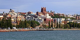
Greater Newcastle is a regional metropolitan area and the second-most-populated district in the state of New South Wales, Australia. It includes the cities of Newcastle and Lake Macquarie; it is the hub of the Lower Hunter region, which includes most parts of the local government areas of City of Newcastle, City of Lake Macquarie, City of Cessnock, City of Maitland and Port Stephens Council.

The City of Lake Macquarie is a local government area in the Hunter Region in New South Wales, Australia. It was proclaimed a city from 7 September 1984. The city is situated adjacent to the city of Newcastle and is widely considered as a part of the Greater Newcastle area. The city is approximately 150 km (93 mi) north of Sydney. One of its major tourist attractions is its lake, also named Lake Macquarie.
Morisset is a commercial centre and suburb of the City of Lake Macquarie local government area in the Hunter region in New South Wales, Australia. Morriset is a part of the Greater Newcastle area, it is located west of the lake of Lake Macquarie just off the M1 Pacific Motorway. It is also located approximately halfway between Gosford and the Newcastle CBD. The count at the 2016 Census was 3,213 for the gazetted suburb of Morisset. The estimated urban population of the Morisset area, including Cooranbong, was 25,662 as at June 2019. The area has experienced moderate growth over the five years to 2019 with an average year-on-year rate of 1.79 percent.

Redfern is an inner southern suburb of Sydney located 3 kilometres (1.9 mi) south of the Sydney central business district and is part of the local government area of the City of Sydney. Strawberry Hills is a locality on the border with Surry Hills. The area experienced the process of gentrification and is subject to extensive redevelopment plans by the state government, to increase the population and reduce the concentration of poverty in the suburb and neighbouring Waterloo.
Swansea is a town at the entrance to Lake Macquarie from the Pacific Ocean in New South Wales, Australia. It is part of the City of Lake Macquarie local government area and is regarded as part of Greater Newcastle. The Aboriginal people, in this area, the Awabakal, were the first people of this land.

Richmond is a town in New South Wales, in the local government area of the City of Hawkesbury. It is located 19 metres above sea level on the alluvial Hawkesbury River flats, at the foot of the Blue Mountains on the Cumberland Plain. It is about 65 km by road from Sydney and about 78 km by road from Lithgow.

Port Macquarie, locally nicknamed Port, is a coastal city in the local government area of Port Macquarie-Hastings. It is located on the Mid North Coast of New South Wales, Australia, about 390 km (242 mi) north of Sydney, and 570 km (354 mi) south of Brisbane. The city is located on the Tasman Sea coast, at the mouth of the Hastings River, and at the eastern end of the Oxley Highway (B56). The city with its suburbs had a population of 47,973 in June 2018.

Tocumwal is a town in the southern Riverina region of New South Wales, Australia, in the Berrigan Shire local government area, near the Victorian border. The town is situated on the banks of the Murray River, 270 kilometres (170 mi) north of the city of Melbourne. The Newell Highway and Murray Valley Highway join at the Murray River, and form part of the main road route National Highway A39 between Brisbane and Melbourne. At the 2016 census, Tocumwal had a population of 2,682. The winner of several 'Tidy Town' awards, Tocumwal is affectionately known as 'The Jewel in the Crown That Is The Riverina District'.

Glenrock Lagoon, an intermediate fresh water small coastal creek, is located within the Lake Macquarie local government area in the Newcastle and Hunter regions of New South Wales, Australia. The lake is located near the Newcastle suburbs of Adamstown and Dudley and is situated about 153 kilometres (95 mi) north of Sydney.

Catherine Hill Bay is a coastal bay and village on the southern peninsula forming Lake Macquarie, south of the Pacific Ocean entrance channel at Swansea in New South Wales, Australia. It is part of the City of Lake Macquarie local government area. The village is the oldest continuous settlement in the City of Lake Macquarie. The Aboriginal people in this area, the Awabakal were the first people of this land.

RAAF Base Rathmines is a heritage-listed former RAAF Second World War seaplane base and now used as community venues, sports venues and a visitor attraction at Dorrington Road, Rathmines, City of Lake Macquarie, New South Wales, Australia. It was in use as an RAAF base from 1939 to 1961. It is also known as Rathmines Park, former RAAF Seaplane Base, Flying Boat Base, Rathmines Aerodrome and Catalina Base. The property is owned by Australian Christadelphian Bible School, Disability Life Enrichment, Don Geddes Nursing Home and Lake Macquarie City Council. The remains of the former air base was added to the New South Wales State Heritage Register on 25 November 2005.

The City of Shellharbour is a local government area in the Illawarra region of New South Wales, Australia. The city is located about 100 kilometres (62 mi) south of Sydney and covers the southern suburbs of the Wollongong urban area centred on Shellharbour and it had an estimated population of 68,460 at the 2016 census.
Windale is a suburb of the city of Lake Macquarie, in the Newcastle metropolitan area. It is located west of the junction of the Pacific Highway and Newcastle Inner City Bypass, covering an area of 1.7 km2 (0.7 sq mi). Windale is a lower socio-economic area consisting largely of public housing homes, and has historically been known for its high rates of alcoholism, crime and unemployment, however recent local government efforts to regenerate the area have been somewhat successful. The suburb was listed as one of the most socially disadvantaged areas in the State according to the 2015 Dropping Off The Edge report.

Wallsend is a western suburb of Newcastle, New South Wales, Australia 11 kilometres (6.8 mi) from Newcastle's central business district. It is split between the City of Newcastle and City of Lake Macquarie local government areas.

Wangi Wangi is a suburb of the City of Lake Macquarie in New South Wales, Australia, which forms a peninsula jutting eastwards into Lake Macquarie. Wangi Wangi is a well known holiday spot, that was frequented in the early days by families from the coalfields. It is known for its views, bush-walking, and fishing spots.
The Rathmines is a suburb of the City of Lake Macquarie in New South Wales, Australia on the western shore of Lake Macquarie between the towns of Toronto and Morisset.
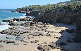
Caves Beach is a locality on the Swansea peninsula between Lake Macquarie and the Pacific Ocean in Greater Newcastle, New South Wales, Australia. It is part of the City of Lake Macquarie local government area. The locality is named for the large number of caves on the nearby coastline. It has a surfing beach which is popular with the local surfers. It is highly popular for spearfishing, with the premier target species being the elusive red morwong. The traditional custodians of the land were the Awabakal people.
Kilaben Bay is a suburb of the city of Lake Macquarie in the Hunter Region of New South Wales, Australia. The Aboriginal people, in this area, the Awabakal, were the first people of this land. It is named for the bay of the same name that lies to the south of the suburb. The suburb's western boundary is heavily forested. Kilaben Bay is one of many suburbs that ring Lake Macquarie, Lake Munmorah, and Tuggerah Lake. Kilaben Bay is part of the West Ward of the City of Lake Macquarie local government area. For telephone call charges, Kilaben Bay is within the local call zone of the City of Newcastle.
Swansea Heads is a locality on the Swansea peninsula between Lake Macquarie and the Pacific Ocean in New South Wales, Australia. It is part of Greater Newcastle, City of Lake Macquarie local government area. The Aboriginal people, in this area, the Awabakal, were the first people of this land.

No. 208 Radar Station RAAF is a heritage-listed former Royal Australian Air Force (RAAF) radar station at Mine Camp at Catherine Hill Bay and Pinny Beach, both in City of Lake Macquarie, New South Wales, Australia. It was established on 10 February 1943. The remains of the radar station were added to the New South Wales State Heritage Register on 22 July 2008.
