
Newcastle, also known as Greater Newcastle, colloquially as Newy and the Steel City, is a large metropolitan area and the second-most-populous city of New South Wales, Australia. It includes the cities of Newcastle and Lake Macquarie and it is the hub of the Lower Hunter region, which includes most parts of the cities of Newcastle, Lake Macquarie, Maitland, Cessnock, and Port Stephens Council.

Wollongong is a city located in the Illawarra region of New South Wales, Australia. The name is believed to originate from the Dharawal language, meaning either 'five islands/clouds', 'ground near water' or 'sound of the sea'. Wollongong lies on the narrow coastal strip between the Illawarra Escarpment and the Pacific Ocean, 85 kilometres south of Sydney. Wollongong had an estimated urban population of 302,739 at June 2018, making it the third-largest city in New South Wales after Sydney and Newcastle and the tenth-largest city in Australia by population. The city's current Lord Mayor is Tania Brown who was elected in 2024.

The City of Lake Macquarie is a local government area (LGA) in the Hunter Region in New South Wales, Australia. It was proclaimed a city on 7 September 1984. It is adjacent to the city of Newcastle and is part of the Greater Newcastle area. The city is approximately 150 km (93 mi) north of Sydney. One of its major tourist attractions is its lake, also named Lake Macquarie.
Swansea is a town at the entrance to Lake Macquarie from the Pacific Ocean in New South Wales, Australia. It is part of the City of Lake Macquarie local government area and is regarded as part of Greater Newcastle.

Port Macquarie, sometimes shortened to Port Mac and commonly locally nicknamed Port, is a coastal city on the Mid North Coast of New South Wales, Australia, 390 km (242 mi) north of Sydney, and 570 km (354 mi) south of Brisbane, on the Tasman Sea coast at the mouth of the Hastings River, and the eastern end of the Oxley Highway (B56). It had a population of 47,974 in 2018, and an estimated population of 51,965 in 2023.
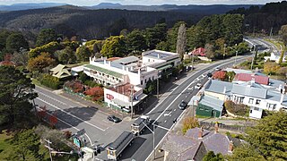
Mount Victoria is a village in the Blue Mountains of New South Wales, Australia. Geographically, Mount Victoria is the westernmost village and suburb of Greater Sydney on the Great Western Highway in the City of Blue Mountains, located about 120 kilometres (75 mi) west-northwest by road from the Sydney central business district and at an altitude of about 1,052 metres (3,451 ft) AHD. At the 2021 Census, the settlement had a population of 945.

Camden Council is a local government area in the Macarthur region of Sydney, in the state of New South Wales, Australia. The area is located south west of the Sydney central business district and comprises 201 square kilometres (78 sq mi) with an estimated population at the 2021 census of 119,325. The mayor of Camden is Cr. Ashleigh Cagney, a member of the Labor Party.

RAAF Base Rathmines is a heritage-listed former RAAF Second World War seaplane base and now used as community venues, sports venues and a visitor attraction at Dorrington Road, Rathmines, City of Lake Macquarie, New South Wales, Australia. It was in use as an RAAF base from 1939 to 1961. It is also known as Rathmines Park, former RAAF Seaplane Base, Flying Boat Base, Rathmines Aerodrome and Catalina Base. The property is owned by Australian Christadelphian Bible School, Disability Life Enrichment, Don Geddes Nursing Home and Lake Macquarie City Council. The remains of the former air base was added to the New South Wales State Heritage Register on 25 November 2005.

The City of Shellharbour is a local government area in the Illawarra region of New South Wales, Australia. The city is located about 100 kilometres (62 mi) south of Sydney and covers the southern suburbs of the Wollongong urban area centred on Shellharbour and it had an estimated population of 68,460 at the 2016 census.

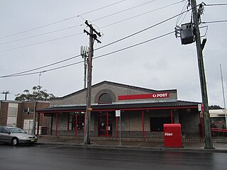
The City of Newcastle is a local government area in the Hunter region of New South Wales, Australia. The City of Newcastle incorporates much of the area of the Newcastle metropolitan area.

Wallsend is a western suburb of Newcastle, New South Wales, Australia, 11 kilometres (6.8 mi) from Newcastle's central business district. It is split between the local government areas of City of Newcastle and City of Lake Macquarie.

Bellambi is a suburb of Wollongong in the Illawarra region of New South Wales, Australia. It has a railway station on the NSW TrainLink South Coast Line.
Rathmines is a suburb of the City of Lake Macquarie in New South Wales, Australia on the western shore of Lake Macquarie between the towns of Toronto and Morisset.
Cooks Hill is an inner city suburb of Newcastle, New South Wales, Australia. It is typified by its tree lined streets, rows of Victorian terrace housing, turn of the century timber cottages and corner pubs.

No. 208 Radar Station RAAF is a heritage-listed former Royal Australian Air Force (RAAF) radar station at Mine Camp at Catherine Hill Bay and Pinny Beach, both in City of Lake Macquarie, New South Wales, Australia. It was established on 10 February 1943. The remains of the radar station were added to the New South Wales State Heritage Register on 22 July 2008.
The Lake Macquarie Petrified Forest is a petrified pine tree forest at Fennell Bay, Lake Macquarie, New South Wales, Australia. Geologically it is located in the Permo-Carboniferous strata. The nearest town is Swansea.
Pinny Beach is a gazetted suburb of the City of Lake Macquarie. It was created on 5 May 2006 following amendments to the boundaries of surrounding suburbs. It is located on the Swansea Peninsula and is to the east of Lake Macquarie, south of the Pacific Ocean entrance channel at Swansea in New South Wales, Australia. It is part of the City of Lake Macquarie local government area.
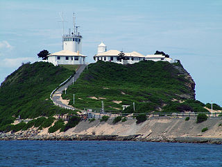
Coal River Precinct is a heritage-listed historic precinct at Nobbys Road, Newcastle, New South Wales, Australia. It was built from 1804 to 1960. It includes Fort Scratchley, Nobbys Head, the Convict Lumber Yard site, Macquarie Pier, the breakwater and Nobby's Beach. It was added to the New South Wales State Heritage Register on 19 December 2003.

Catherine Hill Bay Cultural Precinct is a heritage-listed company town at Catherine Hill Bay in the Hunter Region of New South Wales, Australia. It was added to the New South Wales State Heritage Register on 5 November 2010.

Newcastle Government House is a heritage-listed former military post and official residence and now park and psychiatric hospital at 72 Watt Street, Newcastle, New South Wales, Australia. It is also known as Newcastle Government House and Domain, Newcastle Military Barracks & Hospital, Newcastle Industrial School for Girls, Reformatory for Girls, Lunatic Asylum for Imbeciles, James Fletcher Hospital and Fletcher Park. It was added to the New South Wales State Heritage Register on 22 March 2011.

