Protected areas of Tasmania consist of protected areas located within Tasmania and its immediate onshore waters, including Macquarie Island. It includes areas of crown land managed by Tasmanian Government agencies as well as private reserves. As of 2016, 52% of Tasmania's land area has some form of reservation classification, the majority is managed by the Tasmania Parks & Wildlife Service. Marine protected areas cover about 7.9% of state waters.

The City of Lake Macquarie is a local government area in the Hunter Region in New South Wales, Australia. It was proclaimed a city from 7 September 1984. The city is situated adjacent to the city of Newcastle and is widely considered as a part of the Greater Newcastle area. The city is approximately 150 km (93 mi) north of Sydney. One of its major tourist attractions is its lake, also named Lake Macquarie.

The Macquarie River or Wambuul is part of the Macquarie–Barwon catchment within the Murray–Darling basin, is one of the main inland rivers in New South Wales, Australia.

The Gordon River is a major perennial river located in the central highlands, south-west, and western regions of Tasmania, Australia.

Port Macquarie, locally nicknamed Port, is a coastal city in the local government area of Port Macquarie-Hastings. It is located on the Mid North Coast of New South Wales, Australia, about 390 km (242 mi) north of Sydney, and 570 km (354 mi) south of Brisbane. The city is located on the Tasman Sea coast, at the mouth of the Hastings River, and at the eastern end of the Oxley Highway (B56). The city with its suburbs had a population of 47,973 in June 2018 and an estimated population of 50,307 in June 2023.
Lake Macquarie is Australia's largest coastal lagoon. Located in the City of Lake Macquarie and Central Coast Council local government areas in the Hunter and Central Coast regions of New South Wales, Australia, it covers an area of 110 square kilometres (42.5 sq mi) and is connected to the Tasman Sea by a short channel. Most of the residents of the City of Lake Macquarie live near the shores of the lagoon.

Bulahdelah is a town and locality in the Mid North Coast region of New South Wales, Australia in the Mid-Coast Council local government area. At the 2016 census, the locality had a population of 1,424. The main population centre, where 69% of the area's population lived in 2006, is the town of Bulahdelah.
Martinsville is a small town near Morisset and west of Lake Macquarie in New South Wales, Australia. It is part of the West Ward of the City of Lake Macquarie local government area.
Mandalong is a small rural town in the City of Lake Macquarie in New South Wales, Australia, located near the town of Morisset and west of Lake Macquarie.
Awaba is a town and locality in the City of Lake Macquarie, Greater Newcastle in New South Wales, Australia, inland from Toronto. The name Awaba is of Aboriginal origins, and means "flat or plain surface", referring to Lake Macquarie.
Mirrabooka is a suburb on a peninsula east of the town of Morisset on the western side of Lake Macquarie in New South Wales, Australia. It is part of the West Ward of the City of Lake Macquarie local government area.
Fennell Bay is a lakeside suburb of the City of Lake Macquarie, Greater Newcastle in New South Wales, Australia north of the town of Toronto on a bay of the same name, on the north western shore of Lake Macquarie.
Teralba is a town and suburb of Greater Newcastle, City of Lake Macquarie in New South Wales, Australia, between the towns of Speers Point and Booragul on the northern shoreline of Lake Macquarie. The town first came into being with the construction of the Homebush to Waratah Railway in the early 1880s.
New Lambton Heights is a suburb of Newcastle, New South Wales, Australia, located 9 kilometres (6 mi) west of Newcastle's central business district. It is split between the City of Lake Macquarie and City of Newcastle local government areas.
Yarrawonga Park is a suburb of the City of Lake Macquarie in New South Wales, Australia, and is located on a peninsula east of the town of Morisset on the western side of Lake Macquarie.

The Belmont Anti-Tank Ditch was an anti-tank trench constructed in 1942 as part of the southern perimeter defensive system of the Port of Newcastle, New South Wales, Australia, as part of Fortress Newcastle during World War II. The anti-tank ditch was located 12 kilometres south of Newcastle, south of the town of Belmont.
The Lake Macquarie Petrified Forest is a petrified pine tree forest at Fennell Bay, Lake Macquarie, New South Wales, Australia. Geologically it is located in the Permo-Carboniferous strata. The nearest town is Swansea.
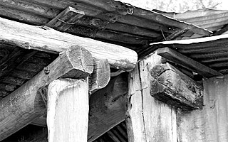
Bush carpentry is an expression used in Australia and New Zealand that refers to improvised methods of building or repair, using available materials and an ad hoc design, usually in a pioneering or rural context.

St Andrew's Church is a heritage-listed Anglican church at 2 Mangerton Street, Toogoolawah, Somerset Region, Queensland, Australia. It was designed by Robin Dods and built from 1911 to 1912 by local builder Donald Alexander Menzies at a cost of £839. It was added to the Queensland Heritage Register on 21 October 1992.

St John's Anglican Church and Macquarie Schoolhouse is a heritage-listed Anglican church building and church hall located at 43-43a Macquarie Road, Wilberforce, City of Hawkesbury, New South Wales, Australia. The church was designed by Edmund Blacket and built from 1819 to 1859 by James Atkinson, senior; and the schoolhouse was built by John Brabyn. The church is also known as the St. John's (Blacket) Church, while the hall is also known as the Macquarie Schoolhouse/Chapel and the Wilberforce Schoolhouse. It was added to the New South Wales State Heritage Register on 20 August 2010.
