The Parkland was an area of specialty for the Darug people and it is still deemed as important by the Aboriginal Land Council.[6] The Parkland has been visited by some early settlers, such as Edward Abbott and George Johnson. The Park was originally used for agricultural purposes which included gardening, dairy farming and grazing.[4]
Prominent early settlers such as Edward Abbott and George Johnson have been associated with the park. The original homestead of Abbotsbury is located within the park, and is leased by the Sydney International Equestrian Centre. In the late 1970s, the northern parts of the regional park had areas for rural residential lots (near Horsley Park), though by 1997 the area was designated as Western Sydney Regional Park, which is 583 hectares in size.[7]
Geography
The regional park is bounded by Westlink M7 to the west in Cecil Park, The Horsley Drive to the north in Horsley Park, Cowpasture Drive to the east in Bossley Park and Elizabeth Drive to the south near Cecil Hills. There exists market gardens in the north, residential piece of land to the east and south, and agricultural residential and rural industrial properties to the west. The regional park is situated within the Fairfield local government area, the Hawkesbury-Nepean and Georges Rivers catchment areas and the Deerubbin Local Aboriginal Land Council’s area. The park is mainly a savanna (i.e. grassy woodland), though it grades into a dry sclerophyll woodland in the southern portion.[4]
Located in the Sydney Basin, the park features three types of soils; the main one being Luddenham soil landscape, which originates from Wianamatta Group Shales on wavy hills, in addition to a small area of Picton Soil landscape. A ridgeline streams from north to south of the park which provides significant regional views from the elevated areas, such as the Moonrise lookout picnic spot in the west of the park. This ridgeline is linked with Prospect Hill to the east near Prospect Reservoir. The regional park rises as one moves to the west of it, with the elevation reaching 140 metres (460ft) at its highest point. Eastern Creek flows southwards at the park's northern end and Ropes Creek flows in the west. The park also features small ponds and wetlands which are a refuge for the native wildlife.[3]
Furthermore, two radio telecommunication towers are situated in the regional park on Border Road. The regional park features a part of the Upper Canal System (by Sydney Water), which was constructed in the late 1800s. Bonnyrigg Reservoir is situated at the southern point of the park.[8]
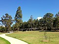
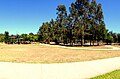
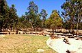
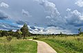
Moonrise Lookout with views of the Sydney skyline.A walking path in the park's savannah-like environmentWallabies spotted in The Dairy
Western Sydney Regional Park features around 135 hectares of developed natural woodland communities where the bulk of the regional park constitutes 427 hectares of planted revegetation and cleared grassland environments, thus providing multifarious habitat areas for wildlife and vegetation communities.[9]
Four vegetation zones are known within the park, which are endangered ecological communities. They are:
Cumberland Plain Woodland: Features the Shale Plains and Shale Hills Woodland, both of which are listed as a critically endangered ecological communities in the Cumberland Plain
River-Flat Eucalypt Forest: Found on coastal floodplain with the subtype Alluvial Woodland
Western Sydney Dry Rainforest: Found in a small pocked of the regional park, and is listed as an endangered ecological community
Moist Shale Woodland: Also listed as an endangered ecological community
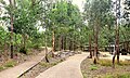
The park is particularly used for family picnics, walking, jogging, cycling, fitness and for its natural environment. Western Sydney Regional Park contains Calmsley Hill Farm, which is protected under State Heritage listing. The park is visited by school students for cross-country, sports and for environmental education. Other visitors include disabled groups, childcare and mothers groups. The park features a broad system of walking and cycling opportunities on various tracks which link the several fundamental recreational areas. One of the main cycling networks within the park is the Western Sydney Parklands-Canal Reserve cycleway. The park also features the Sydney International Equestrian Centre, which was built for the 2000 Olympic Games.[4]
The park's main recreational points include Pimelea, Sugarloaf Ridge, The Dairy and Plough and Harrow picnic areas, all of which have shelters, playgrounds and free barbeques, in addition to large parking spaces. There exists a walking track called the Spotted Gum Trail, which is 3km in length, that loops around Plough and Harrow within the native bushland, thereby allowing walkers to encounter kangaroos and wallabies, in addition to birdwatching.[12] Every entrance to the recreation spots contains prominent planting accompanied by a large signage to indicate access. Access to the park is through Cowpasture Road, Elizabeth Drive and The Horsley Drive.[4]
Recreational areas and facilities include:
Lizard Log – Features a nature themed playground for children, over 20 picnic shelters, scenic walks, a pavilion and an amphitheater.
The Dairy – Features picnic shelters and electric barbeques on a hilltop location.
Plough and Harrow – An area surrounded by native bushland that features a café, a playground, over 20 picnic areas, a high ropes course and an open space at the west end.
Moonrise Lookout – A recreational lookout area that has an altitude ranging from 130 to 140 metres (430 to 460ft) above sea level.
Sugarloaf Ridge – Also a highly elevated lookout area, adjacent to the above place, which features two large picnic shelters.
Calmsley Hill City Farm – An educational farm aimed for school children.
TreeTops Adventure Park – An attraction that features high ropes on tree tops, and includes activities such as multiple zip lines and aerial challenges on the native trees.
The regional park features five walking loops, which all have trail grades:[13]
Moonrise Loop – A challenging, 6.2km walk which features lookouts, and animals such as kangaroos and wallabies being spotted.
Pimelea Loop – An easy 1.6km walk that links Lizard Log and The Dairy with playgrounds, lookouts and waterways.
Sugarloaf Loop – A challenging, 2km walk that offers views of Western Sydney and the Sydney CBD skyline.
Spotted Gums Trail – A 3km long, demanding trail that goes through spotted gum trees.
Plough and Harrow Loop – A gentle 1.6km loop that crosses the picnic areas of the parkland.
↑ RTA (2008) The Western Sydney Regional Aboriginal Heritage Study. NSW Department of Environment and Climate Change
↑ HASSELL (2010b) Draft Western Sydney Parklands Plan of Management 2010–2020.
↑ URS (2004) Western Sydney Regional Parklands, Management Vision and Concept Plan Options, Department of Infrastructure, Planning and Natural Resources.
↑ NSW NPWS (2006) Western Sydney Regional Park Statement of Interim Management Intent. NSW National Parks and Wildlife Service, Cumberland South.
↑ NSW NPWS (2002) Native Vegetation of the Cumberland Plain - Final Edition. NPWS, Sydney.
↑ DECC (2006) A Vertebrate Fauna Survey of Western Sydney Regional Park. Unpublished report. NPWS, Parramatta.
This page is based on this Wikipedia article Text is available under the CC BY-SA 4.0 license; additional terms may apply. Images, videos and audio are available under their respective licenses.