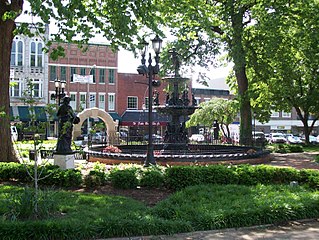
Bowling Green is a home rule-class city and the county seat of Warren County, Kentucky, United States. As of 2019, its population of 70,543 made it the third most-populous city in the state after Louisville and Lexington; its metropolitan area, which is the fourth largest in the state after Louisville, Lexington, and Northern Kentucky, had an estimated population of 177,432; and the combined statistical area it shares with Glasgow has an estimated population of 231,608.

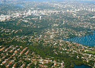
The North Shore refers to a group of suburbs within the Northern Sydney region of Sydney, New South Wales, Australia. The term generally refers to the suburbs located on the northern side of Sydney Harbour up to and including Hornsby and between Middle Harbour and the Lane Cove River, or generally the “inner North-Western” suburbs.
St Leonards is a suburb on the lower North Shore of Sydney, in the state of New South Wales, Australia. St Leonards is located 5 km north-west of the Sydney central business district and lies across the local government areas of Municipality of Lane Cove, North Sydney Council and the City of Willoughby.

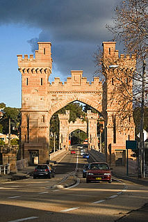
Chatswood is a major business and residential district in the Lower North Shore of Sydney, in the state of New South Wales, Australia, 10 kilometres north of the Sydney central business district. It is the administrative centre of the local government area of the City of Willoughby.

The City of Willoughby is a local government area on the Lower North Shore of Northern Sydney, in the state of New South Wales, Australia. It is located 6 kilometres (3.7 mi) north of the Sydney central business district. It was first proclaimed in October 1865 as the Municipality of North Willoughby.

Artarmon is a suburb on the lower North Shore of Sydney, in the state of New South Wales, Australia, 9 kilometres north-west of the Sydney central business district, in the local government area of the City of Willoughby.

Chatswood Oval is located south of the Chatswood railway station in northern Sydney. It has four small pavilions and seating surrounding the oval. It is one of the Lower North Shore's largest sportsgrounds, and the home ground of the Gordon Rugby Football Club and Gordon District Cricket Club. One of the largest crowds was 8,127 when Gordon Rugby played Randwick in 1976. Gordon Rugby have been playing at Chatswood Oval since 1936. The approximate dimensions of the oval are 145 metres by 112 metres.

Wattle Grove is a suburb of Sydney, in the state of New South Wales, Australia. Wattle Grove is located 30 kilometres south-west of the Sydney central business district in the local government area of the City of Liverpool.

Willoughby is a suburb located on the lower North Shore of Sydney, in the state of New South Wales, Australia 8 kilometres north of the Sydney central business district, in the local government area of the City of Willoughby.
Northbridge is a suburb on the Lower North Shore of Sydney, New South Wales, Australia. It is located 7 kilometres north of the Sydney Central Business District, in the local government area of Willoughby.

Chatswood West is a suburb on the Lower North Shore of Sydney, in the state of New South Wales, Australia. Chatswood West is located 11 kilometres north-west of the Sydney central business district, in the local government areas of the City of Willoughby and City of Ryde. Chatswood is a separate suburb. The area of Chatswood located west of the Pacific Highway is informally known as West Chatswood, which should not be confused with the separate suburb of Chatswood West, nor should it be confused with the West Chatswood Post Office on Railway Street in the Suburb of Chatswood. Chatswood West shares the same postcode as Chatswood which is 2067.

Lane Cove North is a suburb on the Lower North Shore of Sydney of Sydney, in the state of New South Wales, Australia. Lane Cove North is located 11 kilometres north-west of the Sydney central business district, in the local government areas of the Municipality of Lane Cove and the City of Willoughby. Lane Cove and Lane Cove West are separate suburbs.
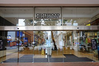
Chatswood Chase Sydney is a shopping centre in the suburb of Chatswood on the Lower North Shore of Sydney.

Westfield Chatswood is a large indoor shopping centre in the suburb of Chatswood in the Lower North Shore of Sydney.

Northern Sydney is a large metropolitan area in Sydney, New South Wales, Australia on the north shore of Sydney Harbour and Parramatta River. The region embraces suburbs in Sydney’s north-east, north and inner north west. Northern Sydney is divided into distinctive regions such as the North Shore, Northern Beaches and Forest District.

Ferndale Park is located in suburban Chatswood, 8 km (5 mi) from the centre of Sydney, Australia. It is an important urban forest reserve, preserving Blackbutt forest and the mossy gully rainforest. Most of this original forest was cleared for agriculture and housing in the 19th and 20th century.

Wetherill Park Nature Reserve, also called Wetherill Park Reserve, is an urban park and a nature reserve situated in the western suburbs of Sydney, New South Wales, Australia. The reserve contains an open woodland and bushland which feature native plants, such as eucalyptus trees, and recreational areas.

The Chatswood South Uniting Church is a heritage-listed Uniting church at 518 Pacific Highway, Lane Cove North in the Lane Cove Council local government area of New South Wales, Australia. It was designed by Thomas Rowe and possibly a Mr Morrow also and built by Bryson, Leet, Johnson & Montgomery. It is also known as Chatswood South Uniting Church and Cemetery and Chatswood South Methodist Church. The property is owned by Chatswood South Uniting Church. It was added to the New South Wales State Heritage Register on 2 April 1999.

St Leonards Park is a heritage-listed bowling club, 15-hectare (37-acre) urban park, rugby field and cricket oval at 283a Miller Street, North Sydney, North Sydney Council, New South Wales, Australia. It was designed by William Tunks, Mayor and built during 1838. It was added to the New South Wales State Heritage Register on 31 July 2015.

Fiddens Wharf or Killara Wharf was a former wharf on the Lane Cove River in Sydney, Australia. Named after the convict Joseph Fidden, the wharf was primarily used for the transport of timber and supplies to and from Sydney in the 19th century. It is unknown whether the original structure was a conventional wharf, or a mooring place with lines connected to a metal ring secured in a nearby rock. Fiddens was one of the three main wharves on the river.


