Blue Gum High Forest

Last updated
Blue Gum High Forest
Sydney Blue Gum Forest Westleigh.jpg
Ecology
Realm Australasia
Biome Temperate broadleaf and mixed forests
Borders
Geography
CountryAustralia
Elevation70–180 metres (230–590 ft)
Coordinates 33°44′12″S151°9′15″E / 33.73667°S 151.15417°E / -33.73667; 151.15417
Climate type Humid subtropical climate (Cfa)

The Blue Gum High Forest of the Sydney Basin Bioregion is a wet sclerophyll forest found in the northern parts of Sydney, New South Wales, Australia. It has been classified as critically endangered, under the New South Wales government's Threatened Species Conservation Act 1995. [1] The principal canopy trees in this forest community are Sydney blue gum and blackbutt which are usually seen between 20 and 40 metres tall. 180 species of indigenous plants have been identified at Dalrymple-Hay Nature Reserve.

Contents

Distribution

The Blue Gum High Forest is restricted to the northern parts of Sydney, on soils based on shale with an annual rainfall over 1100 mm (43 in). Much of it grew on the ridge tops, roughly following the present day Pacific Highway from around Crows Nest up to Hornsby. Also it was recorded on soils based on the Mittagong Formation, volcanic diatremes and exposed shale lenses within the Hawkesbury Sandstone. Blue Gum High Forest grades into Turpentine-Ironbark Forest in drier areas of lower rainfall.

Remnants are found as far west as West Pennant Hills and Eastwood, though most of the few remaining areas are in suburbs such as Pymble, Turramurra and Wahroonga. Turiban Reserve in Wahroonga has particularly tall trees. Two of the larger forest remnants are Dalrymple-Hay Nature Reserve and Sheldon Forest. Around one percent of the original forest remains, and the current remnants amount to an area of 136 hectares (336 acres). [2] [2]

Ecological status

Due to fragmentation and the surrounding urban area, the forest remnants are constantly under threat from invasive plant species. [1] Bush regeneration programs have been put in place for many years. Significant species include Wandering Jew, Madeira vine, passionfruit vine, Chinese privet, ochna and camphor laurel. [3]

Fauna

Sheldon Forest Sheldon Forest Australia.JPG
Sheldon Forest

Ring-tail possums, sugar gliders, brushtail possums and grey-headed flying foxes are common. There are occasional sightings of wallabies. [4]

Birds include rainbow lorikeet (Trichoglossus moluccanus), Australian king parrot (Alisterus scapularis), crimson rosella (Platycercus elegans), currawongs, variegated fairywren (Malurus lamberti), black-faced cuckoo-shrike (Coracina novaehollandiae), superb fairywren (Malurus cyaneus), powerful owl (Ninox strenua), [2] glossy black cockatoo ( Calyptorhynchus lathami ) and silvereyes.

The yellow-bellied sheathtail-bat (Saccolaimus flaviventris) is present though seldom seen.

Flora

Selected plant species of Sydney Blue Gum High Forest
Common nameBotanical nameApprox. heightPlantnet
Principal tree species
Sydney blue gum Eucalyptus saligna 20–40 metres details
Blackbutt Eucalyptus pilularis 25–45 metres details
Associated tree species
Sydney red gum Angophora costata 15–35 metres details
Grey gum Eucalyptus punctata 20–30 metres details
White mahogany Eucalyptus acmenoides 20–30 metres details
Red mahogany Eucalyptus resinifera 20–30 metres details
Turpentine Syncarpia glomulifera 20–30 metres details
Grey ironbark Eucalyptus paniculata 20–35 metres details
White stringybark Eucalyptus globoidea 15–30 metres details
Understorey tree species
Forest oak Allocasuarina torulosa 6–15 metres details
Sweet pittosporum Pittosporum undulatum to 15 metres details
Blueberry ash Elaeocarpus reticulatus to 15 metres details
Hickory Acacia implexa to 10 metres details
Lilly Pilly Acmena smithii to 10 metres details
Shrub species
Hairy clerodendrum Clerodendrum tomentosum to 10 metres details
Coffee bush Breynia oblongifolia to 3 metres details
Sydney golden wattle Acacia longifolia to 8 metres details
Myrtle wattle Acacia myrtifolia 0.3–3 metres details
Bleeding heart Homalanthus populifolius 0.5–5 metres details
Sweet bursaria Bursaria spinosa to 10 metres details
Gorse bitter-pea Daviesia ulicifolia to 2 metres details
Mock olive Notelaea venosa to 9 metres details
Common hop bush Dodonaea triquetra to 3 metres details
Cherry ballart Exocarpos cupressiformis to 8 metres details
Variable muttonwood Myrsine variabilis to 8 metres details
Yellow pittosporum Pittosporum revolutum to 3 metres details
Muttonwood Myrsine howittiana to 8 metres details
Narrow-leaved orangebark Denhamia silvestris to 4 metres details
Australian indigo Indigofera australis to 2.5 metres details
Tick bush Kunzea ambigua to 3.5 metres details
Herbs, grasses and ferns
Tussock grass Poa affinis details
False bracken Calochlaena dubia details
Maidenhair fern Adiantum aethiopicum details
Gristle fern Blechnum cartilagineum details
Sickle fern Pellaea falcata details
Pixie Caps Acianthus fornicatus details
Kidney weed Dichondra repens details
Lilac lily Schelhammera undulata details
Ivy Goodenia Goodenia hederacea details
Blady grass Imperata cylindrica details
Vines
Australian Clematis Clematis aristata details
Wombat berry Eustrephus latifolius details
Bearded tylophora Vincetoxicum barbatum (syn. Tylophora barbata) details
Scented milk vine Leichhardtia suaveolens (syn. Marsdenia suaveolens) details
Dusky coral pea Kennedia rubicunda details
Five leaf water vine Cissus hypoglauca details
Twining Glycine Glycine clandestina details
Wonga wonga vine Pandorea pandorana details
Other species

See also

Related Research Articles

<span class="mw-page-title-main">Brisbane Water National Park</span> Protected area in New South Wales, Australia

Brisbane Water National Park is a national park on the Central Coast of New South Wales, Australia. The national park is situated 70 kilometres (43 mi) north of Sydney and 12 kilometres (7.5 mi) southwest of Gosford. It consists the Brisbane Water and Mooney Mooney Creek waterways.

<span class="mw-page-title-main">Hunter Region</span> Region in New South Wales, Australia

The Hunter Region, also commonly known as the Hunter Valley, Newcastle Region or simply Hunter, is a region in northern New South Wales, Australia, extending from approximately 162 km (101 mi) to 310 km (193 mi) north of Sydney. It contains the Hunter River and its tributaries with highland areas to the north and south. Situated at the northern end of the Sydney Basin bioregion, the Hunter Valley is one of the largest river valleys on the NSW coast, and is most commonly known for its wineries and coal industry.

<span class="mw-page-title-main">Cumberland Plain</span> Plain in Australia

The Cumberland Plain, an IBRA biogeographic region, is a relatively flat region lying to the west of Sydney CBD in New South Wales, Australia. Cumberland Basin is the preferred physiographic and geological term for the low-lying plain of the Permian-Triassic Sydney Basin found between Sydney and the Blue Mountains, and it is a structural sub-basin of the Sydney Basin.

<span class="mw-page-title-main">Yalgoo bioregion</span> Bioregion in Western Australia

Yalgoo is an interim Australian bioregion located in Western Australia. It has an area of 5,087,577 hectares. The bioregion, together with the Avon Wheatbelt and Geraldton Sandplains bioregions, is part of the larger Southwest Australia savanna ecoregion as classified by the World Wildlife Fund.

<span class="mw-page-title-main">Sydney Turpentine-Ironbark Forest</span>

The Sydney Turpentine-Ironbark Forest (STIF) is wet sclerophyll forest community of Sydney, New South Wales, Australia, that is typically found in the Inner West and Northern region of Sydney. It is also among the three of these plant communities which have been classified as Endangered, under the New South Wales government's Threatened Species Conservation Act 1995, with only around 0.5% of its original pre-settlement range remaining.

<span class="mw-page-title-main">Eastern Australian temperate forests</span> Ecoregion in Australia

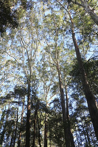
The Eastern Australian temperate forests is a broad ecoregion of open forest on uplands starting from the east coast of New South Wales in the South Coast to southern Queensland, Australia. Although dry sclerophyll and wet sclerophyll eucalyptus forests predominate within this ecoregion, a number of distinguishable rainforest communities are present as well.

<span class="mw-page-title-main">Dalrymple-Hay Nature Reserve</span> Protected area in New South Wales, Australia

The Dalrymple-Hay Nature Reserve is a protected nature reserve that is located in the northerns suburbs of Sydney, New South Wales, Australia. The 10.768-hectare (26.61-acre) reserve is situated in the suburb of St Ives, 15 kilometres (9.3 mi) from the Sydney central business district.

<span class="mw-page-title-main">Lane Cove Bushland Park</span> Forest near Sydney, Australia

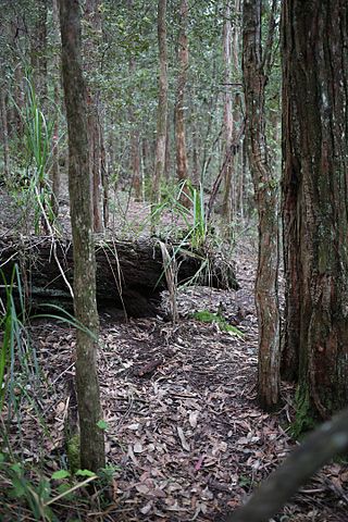
Lane Cove Bushland Park is located in suburban Lane Cove, 5 kilometres from the centre of Sydney, Australia. It is regarded as one of the more interesting areas of fungi in the country. In the year 2000, Bushland Park was placed on the Register of the National Estate, under the Australian Heritage Commission Act, 1975. Average annual rainfall is 1220 mm. Soils are moderately fertile, based on Hawkesbury sandstone and Ashfield Shale. The climate is warm and humid.

<span class="mw-page-title-main">Cambewarra Range Nature Reserve</span>

The Cambewarra Range Nature Reserve, as part of the Kangaroo Valley Group of Nature Reserves, is a protected area located on the cliffs and plateaus of the Kangaroo Valley in the Southern Highlands and South Coast regions of New South Wales in eastern Australia. The Reserve is situated approximately 150 kilometres (93 mi) south of Sydney, 50 kilometres (31 mi) southwest of Wollongong and 16 kilometres (9.9 mi) northwest of Nowra. The Reserve has a total area of 1684 hectares, and includes 11 privately owned properties. It is critical for it to be pristine for a variety of reasons, not the least the catchment of water, as the Reserve floor flows into the Kangaroo Valley River and the Shoalhaven River, from which the Sydney Water Authority draws water to supply large populations in Sydney and Wollongong.

<span class="mw-page-title-main">Cooks River/Castlereagh Ironbark Forest</span>

The Cooks River/Castlereagh Ironbark Forest (CRCIF) is a scattered, dry sclerophyll, open-forest to low woodland and scrubland which occurs predominantly in the Cumberland subregion of the Sydney basin bioregion, between Castlereagh and Holsworthy, as well as around the headwaters of the Cooks River. The Cooks River Clay Plain Scrub Forest is a component of this ecological community, though both belong to a larger occurring community called the Temperate Eucalyptus fibrosa/Melaleuca decora woodland.

<span class="mw-page-title-main">Cumberland Plain Woodland</span> Indigenous woodland community in Sydney, Australia

The Cumberland Plain Woodland, also known as Cumberland Plain Bushland and Western Sydney woodland, is a grassy woodland community found predominantly in Western Sydney, New South Wales, Australia, that comprises an open tree canopy, a groundcover with grasses and herbs, usually with layers of shrubs and/or small trees.

<span class="mw-page-title-main">Ecology of Sydney</span> Geographic aspect of Sydney, Australia

The ecology of Sydney, located in the state of New South Wales, Australia, is diverse for its size, where it would mainly feature biomes such as grassy woodlands or savannas and some sclerophyll forests, with some pockets of mallee shrublands, riparian forests, heathlands, and wetlands, in addition to small temperate rainforest fragments.

<span class="mw-page-title-main">Wallumatta Nature Reserve</span> Protected area in New South Wales, Australia

Wallumatta Nature Reserve, also called the Macquarie Hospital Bushland, is a 6-hectare (15-acre) nature reserve bushland area, surrounded by the residential suburb of East Ryde, in suburban Sydney, Australia. Once part of the Field of Mars of 1804, the reserve is the largest surviving area of Sydney Turpentine-Ironbark Forest, an endangered ecosystem. Soils are based on Ashfield Shale and Hawkesbury Sandstone.

<span class="mw-page-title-main">Clive Evatt Reserve and Turiban Reserve</span> Protected area in New South Wales, Australia

Clive Evatt Reserve and Turiban Reserve are two forest remnants situated on Burns Road, Wahroonga, in Sydney, Australia. Both are of a high conservation status, being some of the last remnants of the critically endangered Blue Gum High Forest in the Sydney basin. Turiban has some of the tallest forest trees in Sydney, some blackbutt exceeding 45 metres tall. Forest restoration programs have been in progress for many years. The weeds ochna and privet being particularly troublesome. Foxes are an invasive mammal species. "Turiban" is said to be a clan of Indigenous Australians who lived north of Sydney.

<span class="mw-page-title-main">Southern Highlands Shale Forest and Woodland</span> Ecological community in New South Wales

The Southern Highlands Shale Forest and Woodland is a mixed grassy woodland and sclerophyll-temperate forest community situated within the Southern Highlands region of New South Wales, Australia. An ecotone featuring clay soils derived from Wianamatta Group, it is listed as an endangered ecological community by the Environment Protection and Biodiversity Conservation Act 1999 as less than 5% of the original extent remains today. Three varieties of the Shale Woodland exist: ‘typical’, ‘tall wet’ and ‘short dry’.

<span class="mw-page-title-main">Blue Mountains and Southern Highlands Basalt Forests</span> Ecological community in New South Wales

The Blue Mountains and Southern Highlands Basalt Forests are a sclerophyll temperate forest community that stretch from the northern fringes of the Blue Mountains to the Southern Highlands. Featuring both wet and dry sclerophyll forests, as well as small rainforest pockets, the community features tall (30m+) and open eucalypt forests and woodlands that lie on igneous rock.

<span class="mw-page-title-main">Shale Sandstone Transition Forest</span> Indigenous woodland community in Sydney, Australia

The Shale Sandstone Transition Forest, also known as Cumberland Shale-Sandstone Ironbark Forest, is a transitory ecotone between the grassy woodlands of the Cumberland Plain Woodlands and the dry sclerophyll forests of the sandstone plateaus on the edges of the Cumberland Plain in Sydney, Australia.

<span class="mw-page-title-main">Blue Mountains Shale Cap Forest</span> Ecological community in New South Wales

The Blue Mountains Shale Cap Forest is a wet-sclerophyll temperate forest community predominantly found in the Blue Mountains, particularly in the Wollemi National Park, and parts of the Hawkesbury.

References

  1. 1 2 "Sydney Blue Gum High Forest" (PDF). Nationally Threatened Species and Ecological Communities. Environment.gov.au. Archived from the original (PDF) on June 18, 2012. Retrieved May 16, 2012.
  2. 1 2 3 "Blue Gum High Forest of the Sydney Basin Bioregion". Threatened species & ecological communities. Australian Government. Retrieved May 17, 2012.
  3. "Best practice guidelines for Blue Gum High Forest" (PDF). Retrieved May 23, 2012.
  4. National Parks & Wildlife Service, info from a Field Officer