Sydney Turpentine-Ironbark Forest

Last updated

Sydney Turpentine-Ironbark Forest
Wallumatta Nature Reserve.jpg
Ecology
Realm Australasia
Biome Temperate broadleaf and mixed forests
Borders
Geography
CountryAustralia
Elevation30–120 metres (98–394 ft)
Coordinates 33°47.666′S151°8.126′E / 33.794433°S 151.135433°E / -33.794433; 151.135433
Geology Sandstone, shale, laminite and siltstone
Climate type Humid subtropical climate (Cfa)

The Sydney Turpentine-Ironbark Forest (STIF) is wet sclerophyll [1] forest community of Sydney, New South Wales, Australia, that is typically found in the Inner West and Northern region of Sydney. It is also among the three of these plant communities which have been classified as Endangered, under the New South Wales government's Threatened Species Conservation Act 1995, [2] [3] with only around 0.5% of its original pre-settlement range remaining. [4]

Contents

As of 26 August 2005, the Australian Government reclassified Sydney Turpentine-Ironbark Forest as a "Critically Endangered Ecological Community", under the Commonwealth's Environment Protection and Biodiversity Conservation Act 1999. [5] The original extent of the forest was 26,516 ha, but now only 1,182 ha (or 4.5% of original extent) remains. [6] It is a transitional biome between Cumberland Plain Woodland in the drier areas and Blue Gum High Forest on neighboring higher rainfall ridges.

Characteristics

Sydney Turpentine-Ironbark Forest contains trees which are around 20–30 metres tall, with ground cover composed of flowering shrubs and native grasses. This type of forest prefers a fertile clay soil derived from shale, with undulating hills and moderate rainfall. Its range does not extend to drier Cumberland Plain Woodland, or high-rainfall ridges (where it meets with Blue Gum High Forest, also endangered), or areas with less fertile, sandy soil. [7]

The main canopy trees in this forest community are Turpentine ( Syncarpia glomulifera , can grow over 30 metres high), and a number of different species of Ironbark, which vary depending on local environmental conditions. Grey Ironbark ( Eucalyptus paniculata ), Narrow-leaved Ironbark ( Eucalyptus crebra ), Red Ironbark [8] or Broad-leaved Ironbark [9] [10] ( Eucalyptus fibrosa ), and Grey Gum ( Eucalyptus punctata ) are commonly found species in the Cumberland Plain area. On the shale caps of the Hornsby plateau, Grey Ironbark and Mountain Mahogany ( Eucalyptus notabilis ) have been noted as being found in association with Turpentine. At the upper end of its rainfall/elevation range, Turpentine-Ironbark forest may intermingle with Blue Gum High Forest and be dominated by Blue Gum ( Eucalyptus saligna ), Mountain Grey Gum ( Eucalyptus cypellocarpa ), Round-leaved Gum ( Eucalyptus deanei ) or Grey Gum. [11]

Understorey plants include wattles such as Parramatta Green Wattle ( Acacia parramattensis ) and Sydney Golden Wattle ( Acacia longifolia ), the Common Hop Bush ( Dodonaea triquetra ), as well as native grasses, herbs and flowers such as Kangaroo Grass ( Themeda australis ) and Australian Bluebell ( Wahlenbergia gracilis ). [12] [13]

Plant species growing in Sydney Turpentine-Ironbark Forest typically number upwards of 70, although fewer species are found in the smaller surviving pockets, and some may not be visible above ground, awaiting climatic conditions favourable for seed germination. [14]

Plant Species of Sydney Turpentine-Ironbark Forest
Common NameBotanical NameApprox. HeightPlantnet
Principal Tree Species
Turpentine Syncarpia glomulifera 30+ metres details
Grey Ironbark Eucalyptus paniculata 25–35 metres details
Associated Tree Species
Grey Box Gum, or Grey Gum Eucalyptus punctata 30–35 metres details
Woollybutt Eucalyptus longifolia 20–35 metres details
White Mahogany Eucalyptus acmenoides 25–50 metres details
Smooth-barked Apple, Sydney Red Gum, or Rusty Gum Angophora costata 15–30 metres details
Thin-leaved Stringybark Eucalyptus eugenioides 15–30 metres details
Broad-leaved, or Red Ironbark Eucalyptus fibrosa 15–35 metres details
White Stringybark Eucalyptus globoidea 15–30 metres details
Understorey Tree Species
Parramatta (Green) Wattle, or Sydney Green Wattle Acacia parramattensis 2–15 metres details
Sicle Wattle Acacia falcata 2–5 metres details
Forest Oak Allocasuarina torulosa 10–25 metres details
White Feather Honey-myrtle Melaleuca decora to 7 metres details
Shrub Species
Coffee Bush Breynia oblongifolia to 3 metres details
Sydney Golden Wattle Acacia longifolia to 8 metres details
Myrtle Wattle, or Red-stemmed Wattle Acacia myrtifolia 0.3–3 metres details
Sweet Bursaria, Blackthorn, or Boxthorn Bursaria spinosa to 10 metres details
Gorse Bitter-pea Daviesia ulicifolia to 2 metres details
Large Mock Olive, Large-leaved Olive Notelaea longifolia to 9 metres details
Common Hop Bush, Large-leaf Hop Bush Dodonaea triquetra to 3 metres details
Cherry Ballart, or Native Cherry Exocarpos cupressiformis to 8 metres details
Elderberry Panax ( Myrsine variabilis ) Rapanea variabilis - details
Yellow Pittosporum, Wild Yellow Jasmine, Rough fruit P. Pittosporum revolutum - details
Muttonwood, ( Myrsine howittiana ) Rapanea howittiana - details
Orange Bark, Narrow-leaved Orangebark, Orange Bush Denhamia silvestris to 4.5 metres details
Groundcover Species
Pale Vanilla Lily Arthropodium milleflorum - details
Dumplings, Apple Berry, Hairy Apple Berry Billardiera scandens to 0.5 metres details
Blue Trumpet, Blue Yam Brunoniella australis 2 cm-15 cm details
Swamp Pennywort, Indian Pennywort, Gotu Cola Centella asiatica - details
Old Man’s Beard, or Headache Vine Clematis glycinoides - details
Sedge, Slender Flat-sedge Cyperus gracilis - details
Blue Flax Lilly Dianella caerulea - details
Rare Plume Grass Dichelachne rara to 1.2 metres details
Love Grass, or Paddock Lovegrass Eragrostis leptostachya to 1 metre details
Love Creeper Glycine tabacina - details
Violet-leaved Goodenia, Forest Goodenia, Ivy Goodenia Goodenia hederacea to 80 cm details
Kangaroo Grass Themeda australis to 1.2 metres details
Australian Bluebell, or Sprawling Bluebell Wahlenbergia gracilis 5 cm-80 cm details
Wallaby Grass Danthonia linkii to 70 cm details
Wallaby Grass Danthonia racemosa - details
Wallaby Grass ( Austrodanthonia tenuior ) Danthonia tenuior to 1.1 metres details
False Sarsparilla, Purple Coral Pea, Waraburra Hardenbergia violacea - details
Wonga Vine Pandorea pandorana - details
Slender Stackhousia Stackhousia viminea to 70 cm details
Other Species
Acacia decurrens Acacia implexa Angophora floribunda Aristida vagans Cheilanthes sieberi Clematis aristata
Clerodendrum tomentosum Commelina cyanea Corymbia gummifera Dichondra repens Dodonaea triquetra Echinopogon caespitosus
Elaeocarpus reticulatus Entolasia marginata Entolasia stricta Eucalyptus resinifera Glycine clandestina Goodenia hederacea
Goodenia heterophylla Imperata cylindrica Indigofera australis Kennedia rubicunda Kunzea ambigua Lepidosperma laterale
Leucopogon juniperinus Lomandra longifolia Microlaena stipoides Oplismenus aemulus Oxalis exilis Ozothamnus diosmifolius
Panicum simile Pittosporum undulatum Poa affinis Polyscias sambucifolia Pomax umbellata Poranthera microphylla
Pratia purpurascens Pseuderanthemum variabile Rubus parvifolius Smilax glyciphylla Stipa pubescens Vincetoxicum barbatum (syn. Tylophora barbata)
Veronica plebeia Zieria smithii
List sources: Ryde City Council [15] and NSW National Parks & Wildlife Service. [16]

Distribution

The natural distribution of Sydney Turpentine–Ironbark Forest is limited to the Sydney Region, and occurs in areas with deep clay soils derived from Wianamatta shale, or shale layers within Hawkesbury sandstone. [17] Occurring on plateaus and hillsides and on the margins of shale cappings over sandstone, [18] it mainly survives today in the local government area of the City of Ryde, where it was probably once the predominant forest type in the area. [19]

STIF grew in clay soils overlaying the sandstone of the Hornsby plateau, as well as in Sydney’s inner-west where the annual rainfall is between 900 and 1,000mm. Because the land favoured by Sydney Turpentine-Ironbark Forest plant species is very fertile (more so than the sandy soils derived from Hawkesbury sandstone), after British settlement much of the land was cleared for its timber, as well as for subsequent farming activity. Much of this forest type's area of distribution is now occupied by suburban dwellings. [20]

Very few remnants of Sydney Turpentine-Ironbark Forest still exist. The most substantial undisturbed area is the Wallumatta Nature Reserve on the corner of Twin and Cressy roads North Ryde, which is owned and managed by the National Parks and Wildlife Service. Progressively smaller remnants can be found in Stewart Park, Marsfield (at the intersection of Epping and Vimiera roads), in the grounds of Macquarie University, and at Meadowbank Park, Meadowbank. Another known remnant of significance surviving in Australia is the Newington Forest near Sydney Olympic Park at Homebush. [21] In the early 1990s, the Concord Local Council initiated a regeneration project to restore STIF bushland within the 3.5-hectare Queen Elizabeth II Park, bordered by Gipps, Broughton and Crane streets, and Addison Avenue, Concord. The project is continuing and expanding under the care of the new Canada Bay City Council and the Concord Bushcare Group. [22] While Queen Elizabeth II Park contains a mixture of Sydney Turpentine-Ironbark Forest and non-indigenous species, there is other Sydney Turpentine-Ironbark Forest bushland in the City of Canada Bay area, located on the Department of Health estate surrounding Concord Hospital at Concord West. Located to the south of the main hospital, a relatively intact area of Sydney Turpentine-Ironbark Forest species may be found in the Dame Eadith Walker Reserve at the Yaralla Estate (private grounds of the Dame Edith Walker Hospital). [23]

Outside these few remaining areas, scattered fragments of Sydney Turpentine-Ironbark Forest have been identified in the local government areas of Ashfield, Auburn, Canterbury, Concord, Drummoyne, Leichhardt, Marrickville, Bankstown, Ryde (Darvall Park and Brush Farm Park), [24] Hunters Hill, Baulkham Hills, Ku-ring-gai (Sheldon Forest), Hornsby, Parramatta, Bankstown, Rockdale, Kogarah, Hurstville, and Sutherland. In heavily urbanised areas of the inner western suburbs, forest fragments can exist simply as an isolated tree belonging to a STIF species. [25] The NSW Scientific Committee, an agency of the New South Wales Department of Environment and Climate Change, has noted the importance of identifying these scattered forest fragments in the interest of genetic diversity, as they "may be important sources of propagation material for use in rehabilitation projects." [26]

Ryde City Council is aware of the near-extinction of this indigenous forest environment, and requires that if any tree becomes unsafe and requires removal, that a replacement must be chosen from the list of tree species indigenous to the particular area. The council's website also encourages local residents in appropriate areas to choose trees, shrubs and ground covers indigenous to the Sydney Turpentine-Ironbark Forest. [27]

See also

Related Research Articles

<span class="mw-page-title-main">Goobang National Park</span> Protected area in New South Wales, Australia

Goobang is a national park located in New South Wales, Australia, 296 kilometres (184 mi) northwest of Sydney. It protects the largest remnant forest and woodland in the central west region of the state, where interior and coastal New South Wales flora and fauna species overlap. Originally named Herveys Range by John Oxley in 1817, the area was reserved in 1897 as state forest because of its importance as a timber resource, and was designated a national park in 1995.

<span class="mw-page-title-main">North Ryde, New South Wales</span> Suburb of Sydney, New South Wales, Australia

North Ryde is a suburb located in the Northern Sydney region of Sydney, New South Wales, Australia. North Ryde is located 15 kilometres north-west of the Sydney central business district, in the local government area of the City of Ryde.

<span class="mw-page-title-main">Macquarie Park, New South Wales</span> Suburb of Sydney, New South Wales, Australia

Macquarie Park is a suburb in the Northern Sydney region of Sydney, New South Wales, Australia. Macquarie Park is located 13 kilometres north-west of the Sydney central business district in the local government area of the City of Ryde.

<span class="mw-page-title-main">East Ryde, New South Wales</span> Suburb of Sydney, New South Wales, Australia

East Ryde is a suburb of Sydney in the state of New South Wales, Australia. East Ryde is in the Northern Sydney region and is located 12 kilometers north-west of the Sydney central business district, in the local government area of the City of Ryde. East Ryde sits on the western bank of the Lane Cove River. East Ryde shares the postcode of 2113 with the adjacent suburb of North Ryde, though it does not have a post office of its own.

Wallumatta was the original name given to the Ryde-Hunters Hill area of Northern Sydney, Australia. Prior to the time that the area was known as Kissing Point, Wallumatta was the formal title and was named in honour of the area's native inhabitants: The Wallumettagal Aboriginal tribe.

<span class="mw-page-title-main">Cumberland Plain</span> Plain in Australia

The Cumberland Plain, an IBRA biogeographic region, is a relatively flat region lying to the west of Sydney CBD in New South Wales, Australia. Cumberland Basin is the preferred physiographic and geological term for the low-lying plain of the Permian-Triassic Sydney Basin found between Sydney and the Blue Mountains, and it is a structural sub-basin of the Sydney Basin.

<span class="mw-page-title-main">Duck River (New South Wales)</span> River in New South Wales, Australia

The Duck River is a perennial stream and southern tributary of the Parramatta River, in Sydney, New South Wales, Australia.

Coxs Creek, a watercourse of the Cooks River catchment, is located in the Inner West of Sydney, in New South Wales, Australia.

<span class="mw-page-title-main">Eastern Australian temperate forests</span> Ecoregion in Australia

The Eastern Australian temperate forests is a broad ecoregion of open forest on uplands starting from the east coast of New South Wales in the South Coast to southern Queensland, Australia. Although dry sclerophyll and wet sclerophyll eucalyptus forests predominate within this ecoregion, a number of distinguishable rainforest communities are present as well.

<span class="mw-page-title-main">Dalrymple-Hay Nature Reserve</span> Protected area in New South Wales, Australia

The Dalrymple-Hay Nature Reserve is a protected nature reserve that is located in the northerns suburbs of Sydney, New South Wales, Australia. The 10.768-hectare (26.61-acre) reserve is situated in the suburb of St Ives, 15 kilometres (9.3 mi) from the Sydney central business district.

<span class="mw-page-title-main">Garawarra State Conservation Area</span> Protected area in New South Wales, Australia

The Garawarra State Conservation Area is a protected conservation area that is located on the southern suburban fringe of Greater Sydney, in the state of New South Wales, in eastern Australia. The 949-hectare (2,350-acre) reserve abuts the Royal National Park and is situated 40 kilometres (25 mi) south of the Sydney central business district, near Helensburgh. Garawarra was gazetted as a park in 1987, and added, together with the Royal National Park, to the Australian National Heritage List on 15 September 2006.

<span class="mw-page-title-main">Lane Cove Bushland Park</span> Forest near Sydney, Australia

Lane Cove Bushland Park is located in suburban Lane Cove, 5 kilometres from the centre of Sydney, Australia. It is regarded as one of the more interesting areas of fungi in the country. In the year 2000, Bushland Park was placed on the Register of the National Estate, under the Australian Heritage Commission Act, 1975. Average annual rainfall is 1220 mm. Soils are moderately fertile, based on Hawkesbury sandstone and Ashfield Shale. The climate is warm and humid.

<span class="mw-page-title-main">Southern Sydney sheltered forest</span>

The Southern Sydney sheltered forest, or the Sydney Sandstone Gully Forest (SSGF), is a vegetation community found in Sydney, Australia that comprises an open forest composition grading into woodland or scrub, typically within gullies. The community is normally associated with sheltered heads and upper inclines of gullies on transitional zones where sandstone outcropping may be present.

<span class="mw-page-title-main">Western Sydney Regional Park</span> Park in Sydney

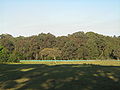
Western Sydney Regional Park is a large urban park and a nature reserve situated in Western Sydney, Australia within the suburbs of Horsley Park and Abbotsbury. A precinct of Western Sydney Parklands, a park system, and situated within the heart of the Cumberland Plain Woodland, the regional park features several picnic areas, recreational facilities, equestrian trails, and walking paths within the Australian bush.

The Kangaroo River Nature Reserve, part of the Kangaroo Valley Group of Nature Reserves, is a protected nature reserve that is located on the floor of the Kangaroo Valley in the Southern Highlands and South Coast regions of New South Wales in eastern Australia. The reserve is situated approximately 150 kilometres (93 mi) south of Sydney, 50 kilometres (31 mi) southwest of Wollongong and 16 kilometres (9.9 mi) northwest of Nowra. The reserve has a protective covenant placed upon it with purpose to ensure the protection of the natural heritage of this area. National parks in the area include the Morton National Park and the Budderoo National Park. Other nature reserves in the area include the Barren Grounds Nature Reserve, and the Cambewarra Range, Barrengarry and Rodway nature reserves – the latter three part of the Kangaroo Valley Group of Nature Reserves.

<span class="mw-page-title-main">Cooks River/Castlereagh Ironbark Forest</span>

The Cooks River/Castlereagh Ironbark Forest (CRCIF) is a scattered, dry sclerophyll, open-forest to low woodland and scrubland which occurs predominantly in the Cumberland subregion of the Sydney basin bioregion, between Castlereagh and Holsworthy, as well as around the headwaters of the Cooks River. The Cooks River Clay Plain Scrub Forest is a component of this ecological community, though both belong to a larger occurring community called the Temperate Eucalyptus fibrosa/Melaleuca decora woodland.

<span class="mw-page-title-main">Cumberland Plain Woodland</span> Indigenous woodland community in Sydney, Australia

The Cumberland Plain Woodland, also known as Cumberland Plain Bushland and Western Sydney woodland, is a grassy woodland community found predominantly in Western Sydney, New South Wales, Australia, that comprises an open tree canopy, a groundcover with grasses and herbs, usually with layers of shrubs and/or small trees.

<span class="mw-page-title-main">Prospect Nature Reserve</span>

Prospect Nature Reserve is a nature reserve and recreational area that is situated in the western suburbs of Sydney, New South Wales, Australia, which incorporates the Prospect Reservoir, and also features picnic spots, lookouts, walking tracks and BBQ areas within the Australian bush. It is located within the Blacktown City local government area, but is also close to the boundaries of Cumberland Council and the City of Fairfield.

<span class="mw-page-title-main">Ecology of Sydney</span> Geographic aspect of Sydney, Australia

The ecology of Sydney, located in the state of New South Wales, Australia, is diverse for its size, where it would mainly feature biomes such as grassy woodlands or savannas and some sclerophyll forests, with some pockets of mallee shrublands, riparian forests, heathlands, and wetlands, in addition to small temperate rainforest fragments.

<span class="mw-page-title-main">Wallumatta Nature Reserve</span> Protected area in New South Wales, Australia

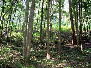
Wallumatta Nature Reserve, also called the Macquarie Hospital Bushland, is a 6-hectare (15-acre) nature reserve bushland area, surrounded by the residential suburb of East Ryde, in suburban Sydney, Australia. Once part of the Field of Mars of 1804, the reserve is the largest surviving area of Sydney Turpentine-Ironbark Forest, an endangered ecosystem. Soils are based on Ashfield Shale and Hawkesbury Sandstone.

References

  1. [https://www.environment.nsw.gov.au/-/media/OEH/Corporate-Site/Documents/Animals-and-plants/Scientific-Committee/Determinations/2019/sydney-turpentine-ironbark-forest-final-determination-CEEC.pdf NSW Threatened Species Scientific Committee. 31 May 2019. Retrieved 28 January 2023.
  2. Threatened Species Conservation Act 1995 (NSW Act of Parliament, online edition).
  3. NSW Department of Environment & Climate Change. "Sydney Turpentine-Ironbark Forest - Sydney Metro: Distribution and vegetation associations in the Sydney Metro". Bushland Corridors in Ryde LGA - Report. NSW Department of Environment & Climate Change . Retrieved 2 July 2007.
  4. OCULUS Environmental Planning (25 May 2001). "Urban Bushland in the Ryde LGA" (PDF). Bushland Corridors in Ryde LGA - Report. Ryde City Council . Retrieved 1 July 2007.
  5. Protection and Biodiversity Conservation Act 1999 (Commonwealth of Australia Act of Parliament, online edition).
  6. Recovering bushland on the Cumberland Plain Department of Environment and Conservation (NSW). (2005). Recovering Bushland on the Cumberland Plain: Best practice guidelines for the management and restoration of bushland. Department of Environment and Conservation (NSW), Sydney. Retrieved 12 September 2022.
  7. NSW Department of Environment & Climate Change (February 2004). "ENDANGERED ECOLOGICAL COMMUNITY INFORMATION: Sydney Turpentine-Ironbark Forest" (PDF). NSW Department of Environment & Climate Change website. Ryde City Council. Archived from the original (PDF) on 30 September 2007. Retrieved 2 July 2007.
  8. Australian Government: Advice to the Minister for the Environment and Heritage from the Threatened Species Scientific Committee (TSSC) on amendments to the List of Ecological Communities under the Environment Protection and Biodiversity Conservation Act 1999 (EPBC Act) (26 August 2005). "Turpentine-Ironbark Forest of the Sydney Basin Bioregion". Environment home > Biodiversity > Threatened species & ecological communities. Department of the Environment and Water Resources . Retrieved 2 July 2007.{{cite web}}: CS1 maint: numeric names: authors list (link)
  9. Ryde City Council (5 January 2007). "NATIVE VEGETATION: Sydney Turpentine - Ironbark Forest". Ryde City Council website. National Parks and Wildlife Service. Archived from the original on 27 August 2007. Retrieved 1 July 2007.
  10. OCULUS Environmental Planning (25 May 2001). "Urban Bushland in the Ryde LGA" (PDF). Bushland Corridors in Ryde LGA - Report. Ryde City Council . Retrieved 1 July 2007.
  11. Australian Government: Advice to the Minister for the Environment and Heritage from the Threatened Species Scientific Committee (TSSC) on amendments to the List of Ecological Communities under the Environment Protection and Biodiversity Conservation Act 1999 (EPBC Act) (26 August 2005). "Turpentine-Ironbark Forest of the Sydney Basin Bioregion". Environment home > Biodiversity > Threatened species & ecological communities. Department of the Environment and Water Resources . Retrieved 2 July 2007.{{cite web}}: CS1 maint: numeric names: authors list (link)
  12. Ryde City Council (5 January 2007). "NATIVE VEGETATION: Sydney Turpentine - Ironbark Forest". Ryde City Council website. National Parks and Wildlife Service. Archived from the original on 27 August 2007. Retrieved 1 July 2007.
  13. OCULUS Environmental Planning (25 May 2001). "Urban Bushland in the Ryde LGA" (PDF). Bushland Corridors in Ryde LGA - Report. Ryde City Council . Retrieved 1 July 2007.
  14. NSW Scientific Committee (16 December 2004). "Sydney turpentine-ironbark forest - endangered ecological community listing". Bushland Corridors in Ryde LGA - Report. National Parks and Wildlife Service. Archived from the original on 5 September 2007. Retrieved 1 July 2007.
  15. OCULUS Environmental Planning (25 May 2001). "Urban Bushland in the Ryde LGA" (PDF). Bushland Corridors in Ryde LGA - Report. Ryde City Council . Retrieved 1 July 2007.
  16. NSW Scientific Committee (16 December 2004). "Sydney turpentine-ironbark forest - endangered ecological community listing". Bushland Corridors in Ryde LGA - Report. National Parks and Wildlife Service. Archived from the original on 5 September 2007. Retrieved 1 July 2007.
  17. OCULUS Environmental Planning (25 May 2001). "Urban Bushland in the Ryde LGA" (PDF). Bushland Corridors in Ryde LGA - Report. Ryde City Council . Retrieved 1 July 2007.
  18. NSW Scientific Committee (16 December 2004). "Sydney turpentine-ironbark forest - endangered ecological community listing". Bushland Corridors in Ryde LGA - Report. National Parks and Wildlife Service. Archived from the original on 5 September 2007. Retrieved 1 July 2007.
  19. OCULUS Environmental Planning (25 May 2001). "Urban Bushland in the Ryde LGA" (PDF). Bushland Corridors in Ryde LGA - Report. Ryde City Council . Retrieved 1 July 2007.
  20. OCULUS Environmental Planning (25 May 2001). "Urban Bushland in the Ryde LGA" (PDF). Bushland Corridors in Ryde LGA - Report. Ryde City Council . Retrieved 1 July 2007.
  21. OCULUS Environmental Planning (25 May 2001). "Urban Bushland in the Ryde LGA" (PDF). Bushland Corridors in Ryde LGA - Report. Ryde City Council . Retrieved 1 July 2007.
  22. City of Canada Bay Council (2007). "Learn and Grow: Bushcare" (PDF). Residents' Guide 2007 pp.73-74. City of Canada Bay . Retrieved 2 July 2007.
  23. City of Canada Bay Council (2007). "Remnant Bushland". Home / Environment and Health / Natural Environment / Remnant Bushland. City of Canada Bay. Archived from the original on 29 August 2007. Retrieved 2 July 2007.
  24. Bushland Environs Advisory Committee for Ryde (11 December 2006). "BEAC Meeting Minutes: 11-Dec-2006" (PDF). City of Ryde Council . Retrieved 2 July 2007.
  25. NSW Scientific Committee (16 December 2004). "Sydney turpentine-ironbark forest - endangered ecological community listing". Bushland Corridors in Ryde LGA - Report. National Parks and Wildlife Service. Archived from the original on 5 September 2007. Retrieved 1 July 2007.
  26. NSW Scientific Committee (16 December 2004). "Sydney turpentine-ironbark forest - endangered ecological community listing". Bushland Corridors in Ryde LGA - Report. National Parks and Wildlife Service. Archived from the original on 5 September 2007. Retrieved 1 July 2007.
  27. Ryde City Council (5 January 2007). "NATIVE VEGETATION: Sydney Turpentine - Ironbark Forest". Ryde City Council website. National Parks and Wildlife Service. Archived from the original on 27 August 2007. Retrieved 1 July 2007.

Commons-logo.svg Media related to Sydney Turpentine-Ironbark Forest at Wikimedia Commons