Hull River is a national park in Queensland (Australia), 1275 km northwest of Brisbane. GIS mapping data from Queensland Department of Natural Resources (2002) showed an area of 3,240 hectares, of which about 2,100 hectares are estuarine mangroves, with the remainder being swamp forests dominated by Melaleuca and specialist Eucalypt species. Rainfall averages 3,600 mm per year. The park is part of the Coastal Wet Tropics Important Bird Area, identified as such by BirdLife International because of its importance for the conservation of lowland tropical rainforest birds.
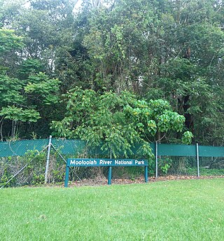
The Mooloolah River National Park is a nationally protected area located on the Sunshine Coast, Queensland. It covers an area of 830.9 hectares and is bordered by the Mooloolah River to the east, Claymore and Dixon Roads to the west, and the Lower Mooloolah River Environmental Reserve to the south. It is bisected by the Sunshine Motorway with the northern, 161.93 hectare component of the Park being a later addition. The Park was initially vacant crown land prior to national park designation in 1960. Surrounding land uses include livestock grazing, urban development and the campus of the University of the Sunshine Coast. It is the second largest mainland park on the coastal lowlands in South East Queensland after Noosa National Park and represents an example of low-lying coastal floodplain distinctive of the region.
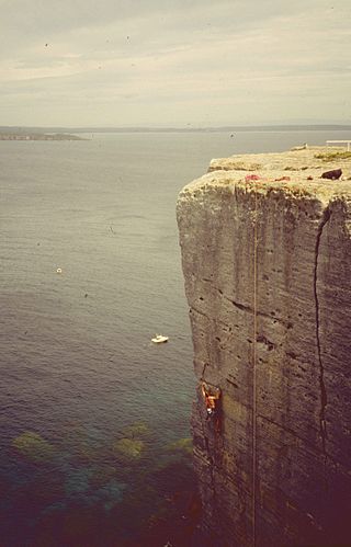
Beecroft Peninsula is the northern headland of Jervis Bay, on Australia's east coast. On the western and southern sides of the peninsula steep sandstone cliffs rise out of the ocean, up to 91 metres at its southernmost point, Point Perpendicular. White sandy beaches are found along the northern, eastern and southern sides interspersed with numerous intertidal reefs.
The Shoalwater Bay Military Training Area is a heritage-listed military installation at Byfield Road, Byfield, Shire of Livingstone, Queensland, Australia. It is a large, relatively undisturbed and intact natural system with a wide variety of coastal landforms and a high level of biodiversity. It contains a diverse range of marine and coastal wetland landscapes, vegetation types and ecosystems. It was added to the Australian Commonwealth Heritage List on 22 June 2004.

The Cumberland Plain, also known as Cumberland Basin, is a relatively flat region lying to the west of Sydney CBD in New South Wales, Australia. An IBRA biogeographic region, Cumberland Basin is the preferred physiographic and geological term for the low-lying plain of the Permian-Triassic Sydney Basin found between Sydney and the Blue Mountains, and it is a structural sub-basin of the Sydney Basin.

Casuarina glauca, commonly known as swamp she-oak, swamp buloke, swamp she-oak, marsh sheoak, grey she-oak, grey she-oak, native pine, or guman by the Gadigal people, is a species of flowering plant that is endemic to eastern Australia. It is a dioecious tree that often forms root suckers and has fissured and scaly bark, spreading or drooping branchlets, the leaves reduced to scales in whorls of 12 to 20, the fruit 9–18 mm (0.35–0.71 in) long containing winged seeds (samaras) 3.5–5.0 mm (0.14–0.20 in) long.

Angophora floribunda, commonly known as the rough-barked apple, is a common woodland and forest tree of the family Myrtaceae native to Eastern Australia. Reaching 30 m (100 ft) high, it is a large tree with fibrous bark and cream-white flowers that appear over the Austral summer. It grows on alluvial soils on floodplains and along watercourses. Much of the land it grew on has been cleared for agriculture.

Parsonsia straminea, commonly known as common silkpod or monkey rope, is a woody vine of the dogbane family, Apocynaceae. It occurs in the states of New South Wales and Queensland in Australia.
The Becher Point Wetlands site is a wetland nature reserve in Port Kennedy on the Swan Coastal Plain of south-western Western Australia. The 677-hectare (1,670-acre) coastal site lies in the City of Rockingham, about 50 kilometres (31 mi) south of the state capital, Perth, and is largely surrounded on the landward side by residential suburbs. It comprises about 200 very small wetlands among sand ridges between Becher Point the Perth-Mandurah Road.
The Federation Walk Coastal Reserve is a reserve comprising the eastern part of The Spit on the Gold Coast, Queensland, Australia. The reserve was opened on 22 June 2003, and is approximately 93 hectares in size. The area supports a subtle mix of habitats including littoral rainforest, native grasslands, and pockets of wetlands. The Federation Walk track goes throughout the reserve.

The Cooks River/Castlereagh Ironbark Forest (CRCIF) is a scattered, dry sclerophyll, open-forest to low woodland and scrubland which occurs predominantly in the Cumberland subregion of the Sydney basin bioregion, between Castlereagh and Holsworthy, as well as around the headwaters of the Cooks River. The Cooks River Clay Plain Scrub Forest is a component of this ecological community, though both belong to a larger occurring community called the Temperate Eucalyptus fibrosa/Melaleuca decora woodland.

The ecology of Sydney, located in the state of New South Wales, Australia, is diverse for its size, where it would mainly feature biomes such as grassy woodlands or savannas and some sclerophyll forests, with some pockets of mallee shrublands, riparian forests, heathlands, and wetlands, in addition to small temperate and subtropical rainforest fragments.
Wide Bay Military Reserve is a heritage-listed military installation at Tin Can Bay Road, Tin Can Bay, Queensland, Australia. The reserve supports a diverse range of plant communities from estuarine, strand, wetlands, heath, tall shrublands and woodlands, to the open forests of the sub-coastal hills and ranges. The total number of bird species recorded for the place totals 250, which is high by Australian standards. It was added to the Australian Commonwealth Heritage List on 22 June 2004.

The Elderslie Banksia Scrub Forest is a critically endangered scrubby woodland situated in southwestern Sydney, New South Wales, Australia. Listed under the Environment Protection and Biodiversity Conservation Act 1999, it is a variety of stunted forest or woodland found on sandy substrates associated with deep Tertiary sand deposits, which has been reduced in extent of at least 90% of its original pre-European extent.
The Western Sydney Dry Rainforest and Moist Woodland is a dry rainforest found in small pockets in south-western Sydney, New South Wales, Australia. Mostly featuring sclerophyll vegetation, it is listed as critically endangered under Australia's national environment law, the Environment Protection and Biodiversity Conservation Act 1999 as more than 70 per cent of its original extent has been reduced as a result of clearing, logging, weed invasion and heavy grazing.

The Lowland Grassy Woodland, or the Illawarra and South Coast Lowland Grassy Woodland is a grassland-savannah community mostly found in the South Coast region of New South Wales, Australia. Stretching from the southern parts of the Illawarra in the north to the South East Corner in the south, it is an endangered ecological community that lies in a rain shadow area.

The River-flat eucalypt forest or Coastal floodplain eucalypt forest is a critically endangered threatened ecological community that is primarily found in southeastern Australia, from southeastern Queensland, through New South Wales, to eastern Victoria, on alluvial soils of the coastal floodplains.

Rainforests and vine thickets are a major vegetation group in Australia. It consists of temperate to tropical rainforests, monsoon forests, and vine thickets. Rainforests and vine thickets are generally found in small pockets across the eastern and northern portions of the continent, including western Tasmania, eastern New South Wales, eastern Queensland, the northern portion of the Northern Territory, and the Kimberley Region of northeastern Western Australia.

