
Southern Moreton Bay Islands is a national park in Queensland, Australia, 44 km southeast of Brisbane. It forms part of the Moreton Bay and Pumicestone Passage Important Bird Area, so identified by BirdLife International because it supports large numbers of migratory waders, or shorebirds.

Moreton Bay is a bay located on the eastern coast of Australia 14 kilometres (8.7 mi) from central Brisbane, Queensland. It is one of Queensland's most important coastal resources. The waters of Moreton Bay are a popular destination for recreational anglers and are used by commercial operators who provide seafood to market.

Bulimba Creek, originally known as Doboy Creek or Doughboy Creek, ia a perennial stream that is a tributary of the Brisbane River, located in suburban Brisbane in the South East region of Queensland, Australia.

Boondall is a northern suburb of the City of Brisbane, Queensland, Australia, formerly known as Cabbage Tree Creek.

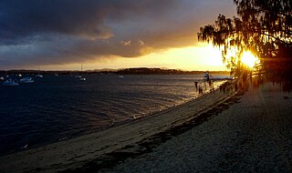
Wynnum is a coastal suburb in the City of Brisbane, Queensland, Australia. In the 2016 census, Wynnum had a population of 12,915. The suburb is a popular destination in Brisbane due to its coastline, jetty and tidal wading pool.

Banyo is a northern suburb of the City of Brisbane, Queensland, Australia. It is a community split between residential and industrial land usage, the latter being attracted by the accessibility of local transport, including the Gateway Motorway. At the 2016 census Banyo had a population of 5,868 people.

Nudgee is a north-eastern suburb in the City of Brisbane, Queensland, Australia. In the 2016 census, Nudgee had a population of 3,578 people.

Nudgee Beach is a suburb and beach in the City of Brisbane, Queensland, Australia. In the 2016 census, the suburb had a population of 263 people.

Deagon is an outer northern suburb in the City of Brisbane, Queensland, Australia. In the 2016 census, Deagon had a population of 3,675 people.

Bramble Bay is an embayment of Moreton Bay in South East Queensland, Australia. The Brisway map reference is 12 H5, or see page 91 G19 in Refidex.

The Kedron Brook is a brook that flows through the northern suburbs of Brisbane in the South East region of Queensland, Australia.
Coochiemudlo Island is a small island in the southern part of Moreton Bay, near Brisbane, in South East Queensland, Australia. It is also the name of the locality upon the island, which is within the local government area of Redland City.
Schulz Canal is an artificial waterway in Nundah, Queensland that enters Moreton Bay. There are tributaries that enter the short canal, draining the suburbs of Hendra and Wooloowin in Brisbane's north east.

The Coombabah Lake Conservation Park is a conservation park that is an Important Wetland in Australia, located in the Gold Coast region of South East Queensland, Australia. Part of the Coomera River catchment, Lake Coombabah is a tidal lake at the mouth of Coombabah Creek. The Coombabah wetlands are significant because they are the most southerly lake and coastal swampland representatives in the bioregion, and because the area provides significant wildlife value and refuge habitat. The conservation area includes tidal marshlands and mangroves along part of the lakes edge. The Melaleuca boardwalk allows viewing of the wildlife. The mangroves are home to frogs, crabs and fish that attract native and migratory birds. There are guided bushwalking and canoeing activities as part of community conservation and environmental workshops to promote local conservation.

Pumicestone Passage, also known as the Pumicestone Channel, is a narrow waterway between Bribie Island and the mainland in Queensland, Australia. The northern extent of the passage is at Caloundra, while at the south is Deception Bay.

Tourism in Brisbane is an important industry for the Queensland economy, being the third-most popular destination for international tourists after Sydney and Melbourne.

St Helena Island is a heritage-listed island in Queensland, Australia, 21 kilometres (13 mi) east of Brisbane and 4 kilometres (2.5 mi) east of the mouth of the Brisbane River in Moreton Bay. Originally used as a prison, it is now a national park. Local Australian Aborigines called the island Noogoon but it was renamed St Helena after an aboriginal named Napoleon was exiled there in 1827. The island is visible from the mainland, particularly the suburbs of Wynnum, Manly and Lota. It has its own permanent water supply, a spring in the centre of the island. Many migratory birds use the island as a watering hole; it forms part of the Moreton Bay and Pumicestone Passage Important Bird Area, so identified by BirdLife International because it supports large numbers of migratory waders, or shorebirds.
Bribie Island Seaside Museum opened on 14 May 2010 at 1 South Esplanade, Bongaree, on the Pumicestone Passage side of Bribie Island, Moreton Bay Region in Queensland, Australia. It is run by Moreton Bay Regional Council.

Toondah Harbour, located in Redland City at Cleveland in southern Moreton Bay, is the location of the Stradbroke Island Ferry Terminal used by water taxis and vehicular ferries to provide access to North Stradbroke Island.

The Geography of Brisbane is characterised by its coastal location in the south eastern corner of the Queensland state of Australia. It is located precisely halfway up the Australian east coast with longitudinal and latitudinal coordinates of 27.5° south and 153° east. The city resides within the Moreton Bay Floodplain, stretching from Caboolture to the north, Beenleigh to the south and as far as Ipswich to the west whilst being bordered by the Pacific Ocean to the east.


