Nudgee Beach, Queensland

Last updated

Map all coordinates using: OpenStreetMap  
Nudgee Beach
Brisbane,  Queensland
Nudgee Beach, Queensland 052013 491.jpg
The beach at low tide, 2013
Australia Queensland location map.svg
Red pog.svg
Nudgee Beach
Coordinates 27°21′14″S153°05′48″E / 27.3539°S 153.0968°E / -27.3539; 153.0968 (Nudgee Beach (centre of suburb))
Population263 (2016 census) [1]
 • Density39.8/km2 (103.2/sq mi)
Postcode(s) 4014
Area6.6 km2 (2.5 sq mi)
Time zone AEST (UTC+10:00)
Location17.9 km (11 mi) NW of Brisbane GPO
LGA(s) City of Brisbane
(Northgate Ward) [2]
State electorate(s) Nudgee
Federal division(s) Lilley
Suburbs around Nudgee Beach:
Shorncliffe Moreton Bay Moreton Bay
Boondall Nudgee Beach Moreton Bay
Nudgee Brisbane Airport Brisbane Airport

Nudgee Beach is a suburb and beach in the City of Brisbane, Queensland, Australia. [3] [4] In the 2016 census, the suburb had a population of 263 people. [1]

Geography

Aerial view of Nudgee Beach (foreground), Kedron Brook, Brisbane Airport, 2006 Brisbane aerial view 05.jpg
Aerial view of Nudgee Beach (foreground), Kedron Brook, Brisbane Airport, 2006
Mouth of Nudgee Creek Avicennia marina seedlings, Nudgee Creek mouth, Nudgee Beach Bramble Bay Queensland IMGP0956.jpg
Mouth of Nudgee Creek

The suburb is 17.9 kilometres (11 mi) north-west of the Brisbane central business district. The suburb is bounded to the north-east by Moreton Bay, to the south-west by Kedron Brook ( 27°22′23″S153°06′23″E / 27.3731°S 153.1065°E / -27.3731; 153.1065 (Kedron Brook) ), to the south-west by the Gateway Motorway, and to the north-west by Nundah Creek ( 27°20′09″S153°05′01″E / 27.3357°S 153.0836°E / -27.3357; 153.0836 (Nundah Creek) ). [5] Directly to the south is Brisbane Airport. [5]

Nudgee Creek rises in Nudgee to the west and meanders through Nudgee Beach where it enters Moreton Bay at 27°20′34″S153°05′39″E / 27.3429°S 153.0941°E / -27.3429; 153.0941 (Nudgee Creek mouth) . [5]

There is a small residential area ( 27°20′45″S153°06′09″E / 27.3459°S 153.1026°E / -27.3459; 153.1026 (Nudgee Beach residential area) ) in the east of the suburb near the beach ( 27°20′36″S153°06′03″E / 27.3433°S 153.1009°E / -27.3433; 153.1009 (Nudgee Beach (beach)) ). [5]

There is a Brisbane City Council waste transfer station (known by the council as a resource recovery centre) in the south of the locality ( 27°21′40″S153°06′01″E / 27.3612°S 153.1003°E / -27.3612; 153.1003 (Nudgee Beach Resource Recovery Centre) ). The remainder of the locality is mangrove wetlands with the northern part of the suburb being part of the Boondall Wetlands. [5]

There is a network of bike tracks which connect through to Toombul shopping centre. [5]

History

Nudgee Beach State School additions, July 1950 Queensland State Archives 1447 Nudgee Beach State School Additions July 1950.png
Nudgee Beach State School additions, July 1950

The name Nudgee comes from the Yuggera word in the Yugarabul dialect, nardha meaning place of ducks, from nar meaning duck and dha meaning place. [3]

Former Nudgee Beach State School, 2006 Nudgee Beach old closed school-1+ (173110849).jpg
Former Nudgee Beach State School, 2006

Nudgee Beach Provisional School opened on 1 April 1926. In 1946 it became Nudgee Beach State School. It closed on 25 March 1988. [6] In 1989 the school reopened as Nudgee Beach Field Study Centre. In 1992 it was renamed Nudgee Beach Environmental Education Centre. [7]

Demographics

At the 2011 census, Nudgee Beach had a population of 261 people. [8] In the 2011 census, Nudgee Beach had a population of 261 people; 48.7% female and 51.3% male. The median age of the Nudgee Beach population was 45 years of age, 8 years above the Australian median. Children aged under 15 years made up 13.8% of the population and people aged 65 years and over made up 17.7% of the population. 77.9% of people living in Nudgee Beach were born in Australia, compared to the national average of 69.8%; the next most common countries of birth were England 4.6%, New Zealand 4.2%, Ireland 2.7%, Germany 1.1%, Papua New Guinea 1.1%. 88.8% of people spoke only English at home; the next most popular languages were 1.9% German, 1.9% Vietnamese, 1.5% Thai, 1.2% Pacific Austronesian Languages. The median weekly household income in Nudgee Beach was $1,224, very similar to the national median of $1,234. Nearly all households in Nudgee Beach (97.0%) were separate houses, there were no semi-detached, row or terrace houses, townhouses etc., and no flats, units or apartments, and 3.0% were classified as "other dwellings". The average household size was 2.5 people. [8]

In the 2016 census, Nudgee Beach had a population of 263 people. [1]

Education

Grey mangroves (Avicennia marina) predominate around Nudgee Creek Avicennia marina dominated community Nudgee Creek Nudgee Beach Bramble Bay Queensland P1040543.jpg
Grey mangroves ( Avicennia marina ) predominate around Nudgee Creek

Nudgee Beach Environmental Education Centre is an Outdoor and Environmental Education Centre at 1588 Nudgee Road ( 27°20′54″S153°06′18″E / 27.3482°S 153.1049°E / -27.3482; 153.1049 (Nudgee Beach Environmental Education Centre) ). [9] [10]

There are no schools in Nudgee Beach. The nearest primary and secondary school is Earnshaw State College in Banyo. [5]

Amenities

There is a boat ramp and floating walkway at Nudgee Beach Road ( 27°21′46″S153°06′10″E / 27.3627°S 153.1029°E / -27.3627; 153.1029 (Nudgee Beach boat ramp) ) providing access to Kedron Brook. [11]

There are four canoe ramps: [12]

Related Research Articles

<span class="mw-page-title-main">Aspley, Queensland</span> Suburb of Brisbane, Queensland, Australia

Aspley is a suburb in the City of Brisbane, Queensland, Australia. In the 2016 census, Aspley had a population of 12,108 people.

<span class="mw-page-title-main">Scarborough, Queensland</span> Suburb of Moreton Bay Region, Queensland, Australia

Scarborough is a coastal suburb on the Redcliffe Peninsula in the Moreton Bay Region, Queensland, Australia. In the 2016 census Scarborough had a population of 8,705 people.

<span class="mw-page-title-main">Kedron, Queensland</span> Suburb of Brisbane, Queensland, Australia

Kedron is a northern suburb in the City of Brisbane, Queensland, Australia. In the 2016 census, Kedron had a population of 9,359 people. It is home to the Queensland Fire and Emergency Services headquarters.

<span class="mw-page-title-main">Nundah, Queensland</span> Suburb of Brisbane, Queensland, Australia

Nundah is an inner suburb in the City of Brisbane, Queensland, Australia. It contains the neighbourhood of Toombul. In the 2016 census, Nundah had a population of 12,141 people.

<span class="mw-page-title-main">Woody Point, Queensland</span> Suburb of Redcliffes, Queensland, Australia

Woody Point is a coastal suburb of Redcliffe in the Moreton Bay Region, Queensland, Australia. In the 2016 census, Woody Point had a population of 4,418 people.

<span class="mw-page-title-main">Boondall, Queensland</span> Suburb of Brisbane, Australia

Boondall is a suburb in the City of Brisbane, Queensland, Australia. In the 2016 census, Boondall had a population of 9,217 people.

<span class="mw-page-title-main">Newstead, Queensland</span> Suburb of Brisbane, Queensland, Australia

Newstead is an inner northern riverside suburb of Brisbane, Queensland, Australia. At the 2021 census, it had a population of 7,496.

<span class="mw-page-title-main">Hendra, Queensland</span> Suburb of Brisbane, Queensland, Australia

Hendra is a suburb of the City of Brisbane, Queensland, Australia. In the 2016 census, Hendra had a population of 4,625 people.

<span class="mw-page-title-main">Northgate, Queensland</span> Suburb of Brisbane, Queensland, Australia

Northgate is a suburb in the City of Brisbane, Queensland, Australia. In the 2016 census, Northgate had a population of 4,568 people.

<span class="mw-page-title-main">Nudgee, Queensland</span> Suburb of Brisbane, Queensland, Australia

Nudgee is a north-eastern suburb in the City of Brisbane, Queensland, Australia. In the 2016 census, Nudgee had a population of 3,578 people.

<span class="mw-page-title-main">Everton Hills, Queensland</span> Suburb of Moreton Bay, Queensland, Australia

Everton Hills is a suburb in the Moreton Bay Region, Queensland, Australia. In the 2016 census, Everton Hills had a population of 5,938 people.

<span class="mw-page-title-main">Bramble Bay</span> River in Queensland, Australia

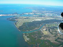
Bramble Bay is an embayment of Moreton Bay in South East Queensland, Australia. The Brisway map reference is 12 H5, or see page 91 G19 in Refidex.

<span class="mw-page-title-main">Macleay Island</span> Town in Queensland, Australia

Macleay Island is an island in Moreton Bay, South East Queensland, Australia. The island constitutes a town and locality within the City of Redland. In the 2016 census, the locality of Macleay Island had a population of 2,681 people.

<span class="mw-page-title-main">Kedron Brook</span> River in Queensland, Australia

The Kedron Brook is a creek that flows through the northern suburbs of Brisbane in the south-east region of Queensland, Australia.

Schulz Canal is an artificial waterway in Nundah, Queensland that enters Moreton Bay. There are tributaries that enter the short canal, draining the suburbs of Hendra and Wooloowin in Brisbane's north east.

<span class="mw-page-title-main">Sandstone Point, Queensland</span> Suburb of Moreton Bay Region, Queensland, Australia

Sandstone Point is a coastal locality in the Moreton Bay Region, Queensland, Australia. In the 2016 census, Sandstone Point had a population of 3,959 people.

<span class="mw-page-title-main">Boondall Wetlands</span>

The Boondall Wetlands lie on the edge of Moreton Bay in the Brisbane suburb of Boondall between Nudgee Beach and Shorncliffe, in south-east Queensland, Australia. The wetlands are preserved within the Boondall Wetlands Reserve which was preserved in 1990 and covers more than 1100 hectares of internationally significant wetlands.

<span class="mw-page-title-main">Kedron Division</span>

The Kedron Division is a former local government area of Queensland, Australia, located in northern Brisbane.

Meldale is a coastal rural locality in the Moreton Bay Region, Queensland, Australia. In the 2016 census, Meldale had a population of 223 people.

<span class="mw-page-title-main">Jacobs Well, Queensland</span> Suburb of Gold Coast, Queensland, Australia

Jacobs Well is a coastal suburb in the City of Gold Coast, Queensland, Australia. In the 2016 census, Jacobs Well had a population of 1,839 people.

References

  1. 1 2 3 Australian Bureau of Statistics (27 June 2017). "Nudgee Beach (SSC)". 2016 Census QuickStats. Retrieved 20 October 2018. OOjs UI icon edit-ltr-progressive.svg
  2. "Northgate Ward". Brisbane City Council. Archived from the original on 12 March 2017. Retrieved 12 March 2017.
  3. 1 2 "Nudgee Beach – suburb in City of Brisbane (entry 43501)". Queensland Place Names. Queensland Government . Retrieved 26 January 2020.
  4. "Nudgee Beach – beach in City of Brisbane (entry 24803)". Queensland Place Names. Queensland Government . Retrieved 16 April 2020.
  5. 1 2 3 4 5 6 7 "Queensland Globe". State of Queensland . Retrieved 15 April 2020.
  6. Queensland Family History Society (2010), Queensland schools past and present (Version 1.01 ed.), Queensland Family History Society, ISBN   978-1-921171-26-0
  7. "Our history". Nudgee Beach Environmental Education Centre. 26 September 2019. Archived from the original on 8 March 2020. Retrieved 16 April 2020.
  8. 1 2 Australian Bureau of Statistics (31 October 2012). "Nudgee Beach (State Suburb)". 2011 Census QuickStats. Retrieved 15 September 2012. OOjs UI icon edit-ltr-progressive.svg
  9. "State and non-state school details". Queensland Government. 9 July 2018. Archived from the original on 21 November 2018. Retrieved 21 November 2018.
  10. "Nudgee Beach Environmental Education Centre". Archived from the original on 21 March 2018. Retrieved 21 November 2018.
  11. "Boating facility locations in Queensland". Marine Safety Queensland. Queensland Government. 17 January 2020. Archived from the original on 19 March 2020. Retrieved 17 April 2020.
  12. "Boat Ramp locations". Brisbane City Council . Archived from the original on 22 May 2022. Retrieved 17 April 2020.