Port of Brisbane

Last updated

Port of Brisbane
Brisbane,  Queensland
Port of Brisbane and Brisbane Airport June 2015.jpg
Moreton Bay, the Port of Brisbane and Brisbane Airport, 2015
Australia Queensland location map.svg
Red pog.svg
Port of Brisbane
Port of Brisbane
Coordinates 27°22′49″S153°10′49″E / 27.3802°S 153.1802°E / -27.3802; 153.1802 (Port Of Brisbane (centre of suburb))
Population0 (2021 census) [1]
 • Density0.000/km2 (0.00/sq mi)
Postcode(s) 4178
Area24.6 km2 (9.5 sq mi)
Time zone AEST (UTC+10:00)
Location22 km (14 mi) from Brisbane GPO
LGA(s) City of Brisbane (Wynnum Manly Ward) [2]
State electorate(s) Lytton
Federal division(s) Bonner
Suburbs around Port of Brisbane:
Bramble Bay Moreton Bay Moreton Bay
Pinkenba Port of Brisbane Moreton Bay
Pinkenba Lytton Moreton Bay

Port of Brisbane is the shipping port and coastal suburb of the City of Brisbane, on the east coast of Queensland, Australia. [3] In the 2021 census, Port of Brisbane had no residents living in the suburb. [1]

Contents

Geography

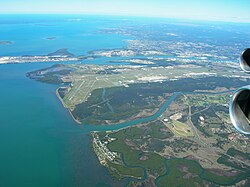
Port of Brisbane is located in the lower reaches of the Brisbane River on Fisherman Islands, an artificial island reclaimed from the smaller Fisherman Islands group at the mouth of the river, adjacent to Brisbane Airport. It currently is the third busiest port in Australia and the nation's fastest growing container port. It is the endpoint of the main shipping channel across Moreton Bay which extends 90 kilometres (56 mi) north to Mooloolaba and is dredged to maintain a depth of 14 metres (46 ft) at the lowest tide.

Brisbane airport and Port of Brisbane Brisbane aerial view 05.jpg
Brisbane airport and Port of Brisbane

Queensland's next two largest ports are the Port of Gladstone and the Port of Townsville.

According to the former Queensland Department of Primary Industries the Port of Brisbane was the most likely entry point of the South American fire ant to Australia. [4]

About 60% of the coal transported through the port originates from the New Acland Mine. [5]

History

In 1980, the narrow gauge (1,067 mm / 3 ft 6 in) Fisherman Islands line was opened between the port and a junction near Lindum on the Cleveland line. This was converted to dual 1,435 mm (4 ft 8+12 in) / 1,067 mm (3 ft 6 in) gauge in 1997 under the Keating Government's One Nation program. [6] [7]

In January 2008, Port of Brisbane Corporation signed an agreement with Brisbane Container Terminals, a wholly owned subsidiary of Hutchison Port Holdings, subsidiary of Hutchison Whampoa, which Hutchison will operate berths 11 and 12 for 42 years. [8]

Deposits of silt and sediment in the ports channels and berths have caused delays of up to five days in the delivery of cargo including oil supplies. [9] This has occurred in 2011, 2013 and 2014. Millions of dollars is spent on dredging annually. [9]

In the 2021 census, Port of Brisbane had no residents. [1]

Facilities

View from Pinkenba, 2015 Port of Brisbane seen from Pinkenba.jpg
View from Pinkenba, 2015
View from Redcliffe, 2016 Port of Brisbane from Redcliffe Point at Redcliffe, Queensland.jpg
View from Redcliffe, 2016

The port is managed by the Port of Brisbane Pty Ltd (PBPL) under a 99-year lease from the Queensland Government. The Port of Brisbane has 29 operating berths including nine deep-water container berths and three deep-water bulk berths as well as 17 bulk and general cargo berths. In total the port facilitates more than 2,600 ships each year and transports more than 28 million tonnes of cargo each year. [10]

Portside Wharf at Hamilton was completed in 2006 and is an international standard facility for cruise liners, offering restaurants, coffee shops, gift shops, and other facilities. However, due to the height restrictions of the Gateway Bridge and length restriction of 270 metres (890 ft) that far upstream, the larger ocean-going cruise liners must dock further down the river at the more industrial Multi User Terminal at the Port of Brisbane. On 2 June 2022, the Brisbane International Cruise Terminal opened on the northern bank of the Brisbane River in the suburb of Pinkenba opposite the port. The cruise terminal is located at Luggage Point next to the Luggage Point Sewage Treatment Plant (which has been renamed the Luggage Point Resource Recovery Centre). The terminal can accommodate the largest cruise vessels in the world. It is operated by the port but will not be part of the suburb of Port of Brisbane. [11]

The port accommodates a visitors centre and in 2005 a shorebird roost was constructed. The bird roost is the largest site built specifically for migratory shorebirds on the east coast of Australia.

The Port of Brisbane Motorway is a short road linking the Gateway Motorway to the Port of Brisbane.

Expansion

BerthYear
opened
LengthUsageOccupier
9-317containers Patrick Corporation
102009372containersPatrick Corporation
112012350containers Hutchinson Ports Australia
122014310containersHutchinson Ports Australia

See also

Related Research Articles

<span class="mw-page-title-main">Transport in Costa Rica</span>

There are many modes of transport in Costa Rica but the country's infrastructure has suffered from a lack of maintenance and new investment. There is an extensive road system of more than 30,000 kilometers, although much of it is in disrepair; this also applies to ports, railways and water delivery systems. According to a 2016 U.S. government report, investment from China that attempted to improve the infrastructure found the "projects stalled by bureaucratic and legal concerns".

<span class="mw-page-title-main">Brisbane</span> Capital city of Queensland, Australia

Brisbane is the capital of the Australian state of Queensland and the third-most populous city in Australia and Oceania, with a population of approximately 2.6 million. Brisbane lies at the centre of South East Queensland, which includes several other regional centres and cities. The central business district is situated within a peninsula of the Brisbane River about 15 km (9 mi) from its mouth at Moreton Bay. Brisbane is located in the hilly floodplain of the Brisbane River Valley between Moreton Bay and the Taylor and D'Aguilar mountain ranges. It sprawls across several local government areas, most centrally the City of Brisbane. The demonym of Brisbane is Brisbanite.

<span class="mw-page-title-main">Moreton Bay</span> Inlet in southern Queensland, Australia

Moreton Bay is a bay located on the eastern coast of Australia 14 kilometres (8.7 mi) from central Brisbane, Queensland. It is one of Queensland's most important coastal resources. The waters of Moreton Bay are a popular destination for recreational anglers and are used by commercial operators who provide seafood to market.

<span class="mw-page-title-main">Port of Felixstowe</span> UK container port in Felixstowe

The Port of Felixstowe, in Felixstowe, Suffolk, is the United Kingdom's largest container port, dealing with 48% of Britain's containerised trade. In 2017, it was ranked as 43rd busiest container port in the world and 8th in Europe, with a handled traffic of 3.85 million twenty-foot equivalent units (TEU). In 2019 it was ranked the UKs 7th busiest port.

Australians generally assumed in the 1850s that railways would be built by the private sector. Private companies built railways in the then colonies of Victoria, opened in 1854, and New South Wales, where the company was taken over by the government before completion in 1855, due to bankruptcy. South Australia's railways were government owned from the beginning, including a horse-drawn line opened in 1854 and a steam-powered line opened in 1856. In Victoria, the private railways were soon found not to be financially viable, and existing rail networks and their expansion were taken over by the colony. Government ownership also enabled railways to be built to promote development, even if not apparently viable in strictly financial terms. The railway systems spread from the colonial capitals, except for a few lines that hauled commodities to a rural port.

<span class="mw-page-title-main">Port of Melbourne</span> Port

The Port of Melbourne is the largest port for containerised and general cargo in Australia. It is located in Melbourne, Victoria, and covers an area at the mouth of the Yarra River, downstream of Bolte Bridge, which is at the head of Port Phillip, as well as several piers on the bay itself. Since 1 July 2003, the Port of Melbourne has been managed by the Port of Melbourne Corporation, a statutory corporation created by the State of Victoria.

<span class="mw-page-title-main">Pinkenba, Queensland</span> Suburb of Brisbane, Queensland, Australia

Pinkenba is a town and eastern coastal suburb within the City of Brisbane, Queensland, Australia. In the 2016 census, Pinkenba had a population of 368 people.

<span class="mw-page-title-main">Chennai Port</span> Container port in India

Chennai Port, formerly known as Madras Port, is the second largest container port of India, behind Mumbai's Jawaharlal Nehru Port also known as Nhava Sheva. The port is the largest one in the Bay of Bengal. It is the third-oldest port among the 13 major ports of India with official port operations beginning in 1881, although maritime trade started much earlier in 1639 on the undeveloped shore. It is an artificial and all-weather port with wet docks. Once a major travel port, it became a major container port in the post-Independence era. An established port of trade of British India since the 1600s, the port remains a primary reason for the economic growth of Tamil Nadu, especially for the manufacturing boom in South India, and has contributed greatly to the development of the city of Chennai. It is due to the existence of the port that the city of Chennai eventually became known as the Gateway of South India.

<span class="mw-page-title-main">Rail gauge in Australia</span> Railway gauges of Australia

Rail gauges in Australia display significant variations, which has presented an extremely difficult problem for rail transport on the Australian continent since the 19th century. As of 2022, there are 11,914 kilometres (7,403 mi) of narrow-gauge railways, 18,007 kilometres (11,189 mi) of standard gauge railways and 2,685 kilometres (1,668 mi) of broad gauge railways. In the 19th century, each of the colonies of Australia adopted their own gauges.

<span class="mw-page-title-main">London Thamesport</span> Container port in England

London Thamesport was a small container seaport on the River Medway, serving the North Sea. It is located on the Isle of Grain, in the Medway unitary authority district of the English county of Kent. The area was formerly called Port Victoria. Since early 2020, Thamesport has no longer operated as a container port, having been eclipsed by the new and much larger London Gateway container port on the Essex coast of the Thames Estuary.

<span class="mw-page-title-main">Rail transport in Queensland</span>

The rail network in Queensland, Australia, was the first in the world to adopt 1,067 mm narrow gauge for a main line, and, in 2013, was claimed to the second largest narrow gauge network in the world, consists of:

<span class="mw-page-title-main">Port of Townsville</span> Port in Australia

Port of Townsville is a government-owned Corporation and seaport in Townsville, Queensland, Australia. It is the third largest seaport in Queensland after Port of Brisbane and the Port of Gladstone. It is located south of the mouth of Ross Creek and north of the Ross River. Main shipping access is through Cleveland Bay. A second seaport, which only exports sugar is found about 100 kilometres (62 mi) north of Townsville at Lucinda and is also managed by Port of Townsville Limited.

<span class="mw-page-title-main">Myrtletown, Queensland</span>

Myrtletown is a former town and now industrial neighbourhood within the suburb of Pinkenba, City of Brisbane, Queensland, Australia.

The Port of Constanța is located in Constanța, Romania, on the western coast of the Black Sea, 179 nautical miles (332 km) from the Bosphorus Strait and 85 nmi (157 km) from the Sulina Branch, through which the Danube river flows into the sea. It covers 3,926 ha, of which 1,313 ha is land and the rest, 2,613 ha is water. The two breakwaters located northwards and southwards shelter the port, creating the safest conditions for port activities. The present length of the north breakwater is 8,344 m (5.185 mi) and the south breakwater is 5,560 m (3.45 mi). The Port of Constanța is the largest on the Black Sea and the 17th largest in Europe.

<span class="mw-page-title-main">Railways in South East Queensland</span>

South East Queensland has a large passenger and freight railway network centred on Brisbane, the capital city of the Australian state of Queensland. Suburban and interurban passenger services in the region are operated by Queensland Rail, which also operates long-distance trains across the state. Aurizon and Pacific National operate freight services. Translink coordinates the suburban services and contracts them out to Queensland Rail.

<span class="mw-page-title-main">Port Botany (seaport)</span> Port in Australia

Port Botany is a deepwater seaport located in Botany Bay in Sydney, Australia. The port is dominated by trade in containerised manufactured products and, to a lesser extent, bulk liquid imports including petroleum and natural gas. It is one of Australia's largest container ports and is administered by NSW Ports which entered into a 99-year lease agreement with the Port Authority of New South Wales in May 2013.

<span class="mw-page-title-main">River Trade Terminal</span>

The River Trade Terminal (RTT) is the only container terminal in Hong Kong for river cargo. The operator is known as River Trade Terminal Company Limited. Located in Siu Lang Shui / Pillar Point, within Tuen Mun Town, Tuen Mun District, it mainly handles and consolidates container and bulk cargo from upstream prior to dispatch to Kwai Tsing Container Terminals and vice versa.

Hutchison Port Holdings Limited, trading as Hutchison Ports, is a private holding company incorporated in the British Virgin Islands. The port operator group is a subsidiary of CK Hutchison Holdings. Some operation of the company were listed as Hutchison Port Holdings Trust in Singapore Exchange.

<span class="mw-page-title-main">Main Line railway, Queensland</span> Railway line in Queensland, Australia

The Main Line is a railway line in South East Queensland, Australia. It was opened in a series of sections between 1865 and 1867. It commences at Roma St Station in Brisbane and extends west 161 km to Toowoomba. It is the first narrow gauge main line constructed in the world. The section of the line from the end of Murphys Creek railway station to the Ruthven Street overbridge, Harlaxton is listed on the Queensland Heritage Register. The Murphys Creek Railway Complex, the Lockyer Creek Railway Bridge (Lockyer), the Lockyer Creek Railway Bridge and Swansons Rail Bridge are also heritage listed.

<span class="mw-page-title-main">Haldia Port</span> Port in India

Haldia Port, officially Haldia Dock Complex (HDC), is a port on the river bank of the confluence of the Haldi River and the Hooghly River. The port is located on the west bank of the Hooghly River at Haldia in West Bengal, about 121 km from the deep sea (sandheads), 45 kilometres (28 mi) upstream from Pilotage Station and 104 km downstream of Kolkata. It developed in independent India in the 1960s, and officially began operations in 1977 as an associate port of the Port of Kolkata. The dock system of the port consists of a lock and riverside jetties. Haldia port mainly handles fully loaded Handy size – carriers of 28,000–40,000 DWT – vessels; but the port has a maximum draft depth of 9 metres (30 ft) and can accommodate vessels up to 230 metres (750 ft) in length.

References

  1. 1 2 3 Australian Bureau of Statistics (28 June 2022). "Port Of Brisbane". 2021 Census QuickStats. Retrieved 15 April 2024. OOjs UI icon edit-ltr-progressive.svg
  2. "Wynnum Manly Ward". Brisbane City Council. Archived from the original on 12 March 2017. Retrieved 12 March 2017.
  3. "Port Of Brisbane – suburb in City of Brisbane (entry 47770)". Queensland Place Names. Queensland Government . Retrieved 26 December 2020.
  4. "Queensland faces possibly worst ever introduced pest". The 7.30 Report . 5 March 2001. Archived from the original on 3 January 2005. Retrieved 28 April 2008.
  5. "Western – Metropolitan Rail Systems Coal Dust Monitoring Program: Pre-veneering monitoring period results" (PDF). Department of Science, Information Technology, Innovation and the Arts. 2013. Archived from the original (PDF) on 29 November 2014. Retrieved 16 November 2014.
  6. Philip Laird (2001). "Australia's gauge muddle and prospects". Back on Track: Rethinking Transport Policy in Australia and New Zealand. UNSW Press. p. 191. ISBN   0-86840-411-X. Archived from the original on 18 January 2023. Retrieved 16 August 2008.
  7. "A Critique of the Dual Gauge Link to the Port of Brisbane". rag.org.au. Archived from the original on 12 May 2008. Retrieved 30 March 2008.
  8. "HPH to invest A$200 million in port of Brisbane". Hutchison Whampoa. 29 January 2008. Archived from the original on 11 June 2011. Retrieved 24 March 2010.
  9. 1 2 Tony Moore (5 December 2014). "Brisbane's oil supplies blocked by Moreton Bay silt problems". Brisbane Times. Fairfax Media. Archived from the original on 26 July 2015. Retrieved 2 April 2015.
  10. Bpa.net.au Archived 19 July 2008 at the Wayback Machine . Bpa.net.au. Retrieved on 2013-07-16.
  11. "Brisbane International Cruise Terminal". Port of Brisbane. Archived from the original on 4 January 2020. Retrieved 4 January 2020.