Bramble Bay

Last updated

Bramble
Port of Brisbane 02.jpg
Bramble Bay, 2009 (top-right of image)
Location
Country Australia
State Queensland
Region South East Queensland
City Brisbane
Basin features
River system Moreton Bay
Tributaries 
  left Brisbane River
  right Pine River

Bramble Bay is an embayment of Moreton Bay in South East Queensland, Australia. The Brisway map reference is 12 H5, or see page 91 G19 in Refidex.

Contents

The Houghton Highway, Hornibrook Bridge and Ted Smout Memorial Bridge span Bramble Bay, connecting Redcliffe with Brisbane.

Shorncliffe Pier Shorncliffe210108.jpg
Shorncliffe Pier

The Brisbane to Gladstone yacht race begins in Bramble Bay. Activities for the annual race are centred on the Shorncliffe pier and nearby foreshore.

Bramble Bay is the most environmentally degraded part of Moreton Bay. [1] Because the bay is so close to the urban populations of Brisbane and Redcliffe the collection of shelled marine animals such as oysters, scallops and limpets is banned. [2] Fishing within bay's closed waters, risks on the spot fines at all times under Queensland's closed water fishing regulations. [2]

Geography

North of Bramble Bay the shoreline forms the southern peninsula shape of the Redcliffe City suburbs of Clontarf and Woody Point. The southern shoreline follows Brisbane City suburbs of Brighton, Sandgate and the northern Shorncliffe shoreline. The former suburb of Cribb Island was also found on the southern shoreline of the bay until it was disbanded for the construction of the Brisbane Airport.

Bramble Bay flows into Hays Inlet to the north-west, and Pine River flows into Bramble Bay to the south-west. Some definitions place the mouth of the Brisbane River and the Boondall Wetlands in Bramble Bay. [1] This would also place the mouths of a number of smaller creeks south of Shorncliffe, including Cabbage Tree Creek (formerly Tighgum Creek), Nundah Creek and Kedron Brook, within the Bramble Bay catchment. [3]

Water quality

Both rivers flowing into Bramble Bay carry high loads of nutrients and suspended sediments. [1] Water in the bay is very turbid. At times two sewerage plumes from the rivers are visible in Bramble Bay. [1] The residence time for Bramble Bay, that is, the period of time that a parcel of water remains at a particular location, is 59 to 62 days, the longest for any part of Moreton Bay. [1]

In 2009, the annual Healthy Waterways Partnership Report Card rated Bramble Bay an F from a previous C. [4] The rating deteriorated because of an increase in phytoplankton and nitrogen concentrations, as well as decreases in water clarity and salinity. [5]

During the past the bay contained large areas of seagrass which attracted feeding dugongs, however there are no seagrass beds in the bay today. [1] This is due to a lack of sunlight reaching the seabed. [6]

See also

Related Research Articles

<span class="mw-page-title-main">Brisbane River</span> River in Queensland, Australia

The Brisbane River is the longest river in South East Queensland, Australia, and flows through the city of Brisbane, before emptying into Moreton Bay on the Coral Sea. John Oxley, the first European to explore the river, named it after the Governor of New South Wales, Sir Thomas Brisbane in 1823. The penal colony of Moreton Bay later adopted the same name, eventually becoming the present city of Brisbane. The river is a tidal estuary and the water is brackish from its mouth through the majority of the Brisbane metropolitan area westward to the Mount Crosby Weir. The river is wide and navigable throughout the Brisbane metropolitan area.

<span class="mw-page-title-main">Moreton Bay</span> Inlet in southern Queensland, Australia

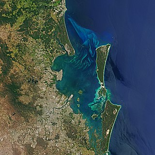
Moreton Bay is a bay located on the eastern coast of Australia 14 kilometres (8.7 mi) from central Brisbane, Queensland. It is one of Queensland's most important coastal resources. The waters of Moreton Bay are a popular destination for recreational anglers and are used by commercial operators who provide seafood to market.

<span class="mw-page-title-main">Aspley, Queensland</span> Suburb of Brisbane, Queensland, Australia

Aspley is a suburb in the City of Brisbane, Queensland, Australia. In the 2016 census, Aspley had a population of 12,108 people.

<span class="mw-page-title-main">Redcliffe Peninsula</span> Town in Queensland, Australia

The Redcliffe Peninsula is a peninsula located in the Moreton Bay Region LGA in the northeast of the Brisbane metropolitan area in Queensland, Australia. The area covers the suburbs of Clontarf, Kippa-Ring, Margate, Newport, Redcliffe, Rothwell, Scarborough and Woody Point.

<span class="mw-page-title-main">Woody Point, Queensland</span> Suburb of Redcliffes, Queensland, Australia

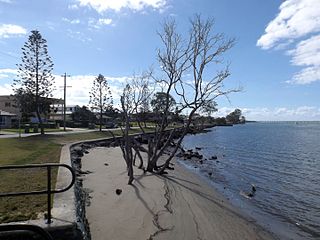
Woody Point is a coastal suburb of Redcliffe in the Moreton Bay Region, Queensland, Australia. In the 2016 census, Woody Point had a population of 4,418 people.

<span class="mw-page-title-main">Bremer River (Queensland)</span> River in Queensland, Australia

The Bremer River is a river that is a tributary of the Brisbane River, located in the Scenic Rim and Brisbane regions of South East Queensland, Australia. The 100-kilometre (62 mi)-long Bremer River drains several Scenic Rim valleys in south-east Queensland, including the Fassifern Valley, with its catchment area covering approximately 2,032 square kilometres (785 sq mi). Most valleys within the catchment have extensive river terraces. The Bremer River system is extremely degraded.

<span class="mw-page-title-main">Boondall, Queensland</span> Suburb of Brisbane, Australia

Boondall is a suburb in the City of Brisbane, Queensland, Australia. In the 2016 census, Boondall had a population of 9,217 people.

<span class="mw-page-title-main">Hays Inlet</span>

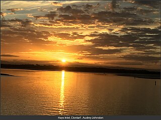
Hays Inlet is a saltwater inlet off Bramble Bay in Moreton Bay Region, Queensland, Australia. The Brisway map reference is 420 L19. A mangrove forest is found in the inlet.

<span class="mw-page-title-main">Shorncliffe, Queensland</span> Suburb of Brisbane, Queensland, Australia

Shorncliffe is a coastal north-eastern suburb in the City of Brisbane, Queensland, Australia. It is on the shore of Bramble Bay, part of Moreton Bay. In the 2016 census, Shorncliffe had a population of 1,870 people. The suburb attracts visitors to its historic Shorncliffe pier, and Lovers Walk, a walking path along the coastline between Shorncliffe and neighbouring Sandgate.

<span class="mw-page-title-main">Shorncliffe pier</span> Historic pier in Brisbane, Australia

Shorncliffe Pier is a historic pier in Shorncliffe, Brisbane, Queensland, Australia, situated near Saint Patrick's College and lower Moora Park. The pier with its white faded timber railings, colonial street lamps spaced out along the stretch of pier, and resting shelter towards the end was a much visited attraction for families, residents and tourists to the area. Reaching 351.5 metres (1,153 ft) out into Bramble Bay it is the largest timber pier in Brisbane and one of the longest recreational piers in Australia. The renewed pier was reopened to the public in March 2016.

<span class="mw-page-title-main">Nudgee Beach, Queensland</span> Suburb of Brisbane, Queensland, Australia

Nudgee Beach is a suburb and beach in the City of Brisbane, Queensland, Australia. In the 2016 census, the suburb had a population of 263 people.

<span class="mw-page-title-main">Pine River (Queensland)</span> River in Queensland, Australia

The Pine River is a small river in South East Queensland, Australia.

<span class="mw-page-title-main">North Pine River</span> River in Queensland, Australia

The North Pine River is a minor river located in South East Queensland, Australia.

<span class="mw-page-title-main">Gympie Road</span>

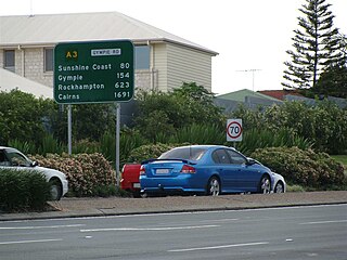
Gympie Road is a major road in the northern suburbs of Brisbane, Queensland, Australia. The road forms part of the main road route from the Brisbane Central Business District (CBD) to the northern suburbs, Sunshine Coast and east coast of Queensland.

<span class="mw-page-title-main">Kedron Brook</span> River in Queensland, Australia

The Kedron Brook is a creek that flows through the northern suburbs of Brisbane in the south-east region of Queensland, Australia.

<span class="mw-page-title-main">Newport, Queensland</span> Suburb of Moreton Bay Region, Queensland, Australia

Newport is a coastal suburb in the Moreton Bay Region, Queensland, Australia. In the 2016 census, Newport had a population of 2,964 people.

Schulz Canal is an artificial waterway in Nundah, Queensland that enters Moreton Bay. There are tributaries that enter the short canal, draining the suburbs of Hendra and Wooloowin in Brisbane's north east.

<span class="mw-page-title-main">Boondall Wetlands</span>

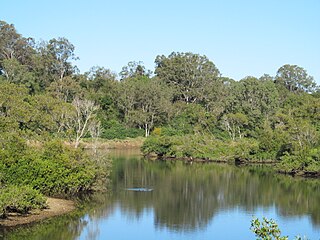
The Boondall Wetlands lie on the edge of Moreton Bay in the Brisbane suburb of Boondall between Nudgee Beach and Shorncliffe, in south-east Queensland, Australia. The wetlands are preserved within the Boondall Wetlands Reserve which was preserved in 1990 and covers more than 1100 hectares of internationally significant wetlands.

<span class="mw-page-title-main">Kedron Division</span>

The Kedron Division is a former local government area of Queensland, Australia, located in northern Brisbane.

<span class="mw-page-title-main">Shire of Toombul</span>

The Shire of Toombul was a local government area of Queensland, Australia, located in northern Brisbane from 1883 to 1925.

References

  1. 1 2 3 4 5 6 Dennison, William C.; Eva G. Abal (1999). Moreton Bay Study: A Scientific Basis for the Healthy Waterways Campaign. Brisbane: South East Queensland Regional Water Quality Management Strategy Team. pp. 32, 196–197. ISBN   0-9586368-1-8.
  2. 1 2 "Shelled critters off limits in Bramble Bay". Queensland Primary Industries and Fisheries. The State of Queensland. 13 July 2009. Archived from the original on 7 June 2011. Retrieved 24 December 2009.
  3. "Brisbane Creeks - Bramble Bay: environmental values and water quality objectives: Basin No. 142 (part): including Bald Hills, Cabbage Tree, Downfall, Kedron Brook, Nudgee and Nundah Creeks" (pdf). Department of Environment and Resource Management. The State of Queensland. 1 March 2007. Retrieved 24 December 2009.[ dead link ]
  4. Brian Williams (22 October 2009). "Moreton Bay water quality results take plunge". The Courier-Mail . Queensland Newspapers . Retrieved 24 December 2009.
  5. "Moreton Bay". Ecosystem Health Monitoring Program Report Card. SEQ Healthy Waterways Partnership. Archived from the original on 23 October 2009. Retrieved 24 December 2009.
  6. "Seagrass". Department of Environment and Resource Management. The State of Queensland. 15 May 2007. Archived from the original on 8 February 2010. Retrieved 24 December 2009.

Coordinates: 27°18′S153°06′E / 27.300°S 153.100°E / -27.300; 153.100