Related Research Articles

The Brisbane River is the longest river in South-East Queensland, Australia, and flows through the city of Brisbane, before emptying into Moreton Bay on the Coral Sea. John Oxley, the first European to explore the river, named it after the Governor of New South Wales, Sir Thomas Brisbane in 1823. The penal colony of Moreton Bay later adopted the same name, eventually becoming the present city of Brisbane. The river is a tidal estuary and the water is brackish from its mouth through the majority of the Brisbane metropolitan area westward to the Mount Crosby Weir. The river is wide and navigable throughout the Brisbane metropolitan area.
Queensland is the second largest state in Australia. It contains 472 separate protected areas with a total land area of 69,388 km2 (26,791 sq mi). 223 of these are National parks, which is the highest number of any Australian state or territory, totalling 65,871 km2 (25,433 sq mi). Seven others are Scientific National Parks, totalling 522 km2 (202 sq mi).

The Logan River is a perennial river located in the Scenic Rim, Logan and Gold Coast local government areas of the South East region of Queensland, Australia. The 184-kilometre (114 mi)-long river is one of the dominant waterways in South East Queensland that drains the southern ranges of the Scenic Rim and empties into Moreton Bay after navigating the City of Logan, a major suburban centre located south of Brisbane. The catchment is dominated by urban and agricultural land use. Near the river mouth are mangrove forests and a number of aquaculture farms.
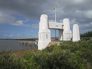
Hornibrook Bridge is a heritage-listed mostly-demolished road bridge on the Hornibrook Highway over Bramble Bay from Brighton, City of Brisbane to Clontarf, Moreton Bay Region, Queensland, Australia. It was designed by Manuel Hornibrook and built from 1932 to 1935 by Manuel Hornibrook. It was added to the Queensland Heritage Register on 7 October 1994.
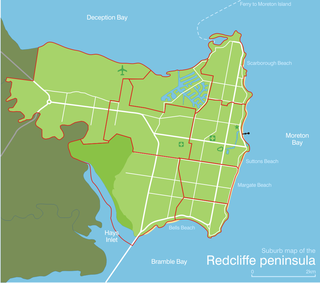
Redcliffe Peninsula is a former municipality north-northeast of Brisbane, the state capital of Queensland, Australia. The area covers the suburbs of Clontarf, Kippa-Ring, Margate, Newport, Redcliffe, Rothwell, Scarborough and Woody Point.

The Shire of Pine Rivers was a local government area about 20 kilometres (12 mi) north of Brisbane in the Moreton Bay region of South East Queensland, Australia. The shire covered an area of 771 square kilometres (297.7 sq mi), and existed as a local government entity from 1888 until 2008, when it amalgamated with councils further north to form the Moreton Bay Region.

Moreton Bay is a locality split between the City of Brisbane and the City of Redland, both in Queensland, Australia. The locality includes all of the bay Moreton Bay between the mainland of the City of Brisbane and the City of Redland across to the western coast of Moreton Island and the western coast of North Stradbroke Island. In the 2016 census, Moreton Bay had a population of 0 people.

Woody Point is a coastal residential suburb of the Moreton Bay Region at the south-east of the Redcliffe peninsula, approximately 24 kilometres (15 mi) north-northeast of Brisbane, the state capital of Queensland, Australia. It was formerly a banana plantation.

The South Pine River is a minor river located in South East Queensland, Australia. It rises on the D'Aguilar Range and passes through the Samford Valley in the Moreton Bay Region local government area.

Bramble Bay is an embayment of Moreton Bay in South East Queensland, Australia. The Brisway map reference is 12 H5, or see page 91 G19 in Refidex.
The Pine River is a small river in South East Queensland, Australia.
The North Pine River is a minor river located in South East Queensland, Australia.

The City of Redcliffe is a former local government area in South East Queensland, Australia. In 2008 it was amalgamated with the Shires of Pine Rivers and Caboolture to create Moreton Bay Region. It is in the northern part of the County of Stanley, with a total area of 38.1 km² and a population of 51,174.
Griffin is a coastal suburb of Brisbane in Moreton Bay Region, Queensland, Australia. It is north of the Brisbane CBD, the state capital. The origin of the suburb name is from the Griffin family who migrated to Australia from the Orkney Islands off the northern coast of Scotland.

The Caboolture River is a small river in South East Queensland, Australia.

The Maroochy River is a river in South East Queensland, Australia. The river rises from the eastern slopes of the Blackall Range and flows east through Eumundi, before entering the sea at Cotton Tree, Maroochydore. Other populated centres in the catchment include Nambour, Eudlo, Yandina and Coolum.
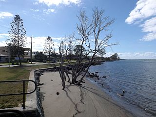
Saltwater Creek is a creek in Rothwell, Moreton Bay Region, Queensland, Australia.

South Passage is channel between the South Pacific Ocean and Moreton Bay. The other entrances to the bay are the North Passage and Jumpinpin Channel in the south.

The Kedron Division is a former local government area of Queensland, Australia, located in northern Brisbane.

Jacobs Well is a coastal suburb of the City of Gold Coast, Queensland, Australia. The suburb is positioned on the delta of the Pimpama River at the southern end of Moreton Bay. At the 2016 Australian Census, the suburb recorded a population of 1,839.
Jacobs Well is best known for its four lane boat ramp, Volunteer Marine Rescue facility and the surrounding sugar cane fields. It is often described as "The Gateway to Southern Moreton Bay"
References
- ↑ "Hays Inlet (entry 15574)". Queensland Place Names. Queensland Government . Retrieved 19 December 2016.
- 1 2 Dennison, William C.; Eva G. Abal (1999). Moreton Bay Study: A Scientific Basis for the Health Waterways Campaign. Brisbane: South East Queensland Regional Water Quality Management Strategy Team. p. 197. ISBN 0-9586368-1-8.