
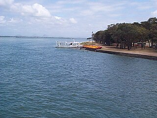
The Brisbane River is the longest river in South East Queensland, Australia, and flows through the city of Brisbane, before emptying into Moreton Bay on the Coral Sea. John Oxley, the first European to explore the river, named it after the Governor of New South Wales, Sir Thomas Brisbane in 1823. The penal colony of Moreton Bay later adopted the same name, eventually becoming the present city of Brisbane. The river is a tidal estuary and the water is brackish from its mouth through the majority of the Brisbane metropolitan area westward to the Mount Crosby Weir. The river is wide and navigable throughout the Brisbane metropolitan area.

Brisbane is the capital and most populous city of Queensland and the third-most populous city in Australia and Oceania, with a population of approximately 2.6 million. Brisbane lies at the centre of South East Queensland, which includes several other regional centres and cities. The central business district is situated within a peninsula of the Brisbane River about 15 km (9 mi) from its mouth at Moreton Bay. Brisbane is located in the hilly floodplain of the Brisbane River Valley between Moreton Bay and the Taylor and D'Aguilar mountain ranges. It sprawls across several local government areas, most centrally the City of Brisbane. The demonym of Brisbane is Brisbanite.
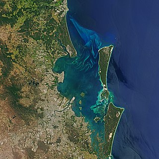
Moreton Bay is a bay located on the eastern coast of Australia 14 kilometres (8.7 mi) from central Brisbane, Queensland. It is one of Queensland's most important coastal resources. The waters of Moreton Bay are a popular destination for recreational anglers and are used by commercial operators who provide seafood to market.

John Joseph William Molesworth Oxley was an explorer and surveyor of Australia in the early period of British colonisation. He served as Surveyor General of New South Wales and is perhaps best known for his two expeditions into the interior of New South Wales and his exploration of the Tweed River and the Brisbane River in what is now the state of Queensland.

The Tweed River is a river situated in the Northern Rivers region of New South Wales, Australia. From the middle reaches of its course, the state boundary between New South Wales and Queensland is located approximately 10 kilometres (6.2 mi) north.
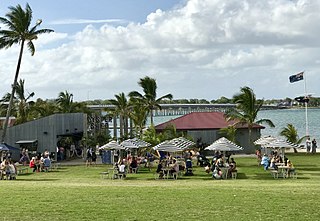
Redcliffe is a town and suburb in the City of Moreton Bay, Queensland, Australia. It also refers colloquially to the Redcliffe Peninsula as a whole, a peninsula jutting into Moreton Bay which contains several other suburbs. Since the 1880s, Redcliffe has been a popular seaside resort in South East Queensland. In the 2016 census, the suburb of Redcliffe had a population of 10,373 people.

The Redcliffe Peninsula is a peninsula located in the City of Moreton Bay in the northeast of the Brisbane metropolitan area in Queensland, Australia. The area covers the suburbs of Clontarf, Kippa-Ring, Margate, Newport, Redcliffe, Rothwell, Scarborough and Woody Point.

South East Queensland (SEQ) is a bio-geographical, metropolitan, political and administrative region of the state of Queensland in Australia, with a population of approximately 3.8 million people out of the state's population of 5.1 million. The area covered by South East Queensland varies, depending on the definition of the region, though it tends to include Queensland's three largest cities: the capital city Brisbane; the Gold Coast; and the Sunshine Coast. Its most common use is for political purposes, and covers 35,248 square kilometres (13,609 sq mi) and incorporates 11 local government areas, extending 240 kilometres (150 mi) from Noosa in the north to the Gold Coast and New South Wales border in the south, and 140 kilometres (87 mi) west to Toowoomba. It is the third largest urban area in Australia by population.

Strathpine is a suburb in the City of Moreton Bay, Queensland, Australia. In the 2016 census, Strathpine had a population of 9,503 people. It is home to the Pine Rivers District offices of the City of Moreton Bay, as well as many businesses, administrative, and local, state and federal government offices. The area is home to Strathpine Centre, a medium-sized urban shopping centre, built by Westfield.

Deception Bay is a coastal suburb in the City of Moreton Bay, Queensland, Australia. In the 2016 census, Deception Bay had a population of 19,850 people.
Murrumba Downs is a suburb in the City of Moreton Bay, Queensland, Australia. In the 2021 Census, Murrumba Downs had a population of 10,795 people.
Rothwell is a coastal suburb in the City of Moreton Bay, Queensland, Australia. In the 2021 census, Rothwell had a population of 7,538 people.

The City of Moreton Bay, known until July 2023 as the Moreton Bay Region, is a local government area in the north of the Brisbane metropolitan city in South East Queensland, Australia. Established in 2008, it replaced three established local government areas, the City of Redcliffe and the Shires of Pine Rivers and Caboolture.
Pumicestone Channel, also known as the Pumicestone Passage, is a narrow, mesotidal waterway around 45 kilometres in length, between Bribie Island and the mainland in Queensland, Australia. The northern extent of the passage is at Caloundra, while at the south is Deception Bay. The waterway is a two way tidal estuary that has 11 creeks flowing into it. At each end of the passage the channels are the deepest and widest.

The Caboolture River is a small river in South East Queensland, Australia.

Wamuran is a rural town and locality in the City of Moreton Bay, Queensland, Australia. In the 2016 census, the locality of Wamuran had a population of 3,196 people.
Sandstone Point is a coastal locality in the City of Moreton Bay, Queensland, Australia. In the 2016 census, Sandstone Point had a population of 3,959 people.

South Passage is channel between the South Pacific Ocean and Moreton Bay. The other entrances to the bay are the North Passage or North Entrance and Jumpinpin Channel in the south.
Burpengary East is a coastal suburb in the City of Moreton Bay, Queensland, Australia. In the 2021 census, Burpengary East had a population of 9,654 people.
Redcliffe Peninsula road network is a group of roads that provide access to the Redcliffe Peninsula in Queensland, Australia, and enable travel between the contained communities. The area serviced by the network includes the localities of Clontarf, Kippa-Ring, Margate, Newport, Redcliffe, Rothwell, Scarborough and Woody Point.


