Gumdale, Queensland

Last updated

Gumdale
Brisbane,  Queensland
Grassdale Road Gumdale.jpg
Grassdale Road, 2014
Australia Queensland location map.svg
Red pog.svg
Gumdale
Gumdale, Queensland
Coordinates 27°29′41″S153°09′21″E / 27.4947°S 153.1558°E / -27.4947; 153.1558 (Gumdale (centre of suburb))
Population2,118 (2016 census) [1]
 • Density471/km2 (1,219/sq mi)
Postcode(s) 4154
Area4.5 km2 (1.7 sq mi)
Time zone AEST (UTC+10:00)
Location15.6 km (10 mi) ESE of Brisbane GPO
LGA(s) City of Brisbane
(Chandler Ward) [2]
State electorate(s) Chatsworth
Federal division(s) Bonner
Suburbs around Gumdale:
Tingalpa Wakerley Wakerley
Belmont Gumdale Ransome
Belmont Chandler Chandler

Gumdale is an outer suburb of the City of Brisbane, Queensland, Australia. [3] In the 2016 census, Gumdale had a population of 2,118 people. [1]

Contents

Geography

Gumdale is 17.7 kilometres (11.0 mi) by road ESE of the Brisbane CBD. The average property size in Gumdale is approximately between 5,000 to 10,000 square metres (1.2 to 2.5 acres) making Gumdale consist mostly of acreages. However, access to Brisbane city is only 15 to 20 minutes away by car. Gumdale has several new development sites consisting of less than 5% of housing, the other 95% are acreages. It is Brisbane's nearest acreage suburb to the CBD.[ citation needed ]

History

Gumdale Hall on New Cleveland Road opened in 1937 StateLibQld 2 179375 Gumdale Hall on New Cleveland Road opened in 1937.jpg
Gumdale Hall on New Cleveland Road opened in 1937

The Grassdale Land Company Limited formed on 8 January 1885 to acquire the property known as Grassdale Paddocks, in the parish of Tingalpa, with registered shareholders holding 80 shares of 250 pounds each. [4] This area is spread across the Brisbane suburbs of Gumdale, Belmont and Chandler. The company offered the land for auction in the Grassdale Estate later in 1885. [5] The allotments were situated along Grassdale Road, London Road, Boston Road, Old Cleveland Road, Archer Street and four unnamed roads (later called Belmont Road, Stanborough Road, Tilley Road and New Cleveland Road). Prior to the sale extensive publicity was published in the Brisbane newspapers, calling for "the attention of the investor, capitalist, farmer, merchant, artizan [sic], and mechanic, and is only one hour's drive from Brisbane, and as it has been decided to run the Cleveland Railway through the Estate, it will be brought within a few minutes' ride of the heart of the city". [6] The results of the public auction on 28 November 1885 were reported in the Telegraph newspaper with "forty-two lots were disposed of, comprising an area of 144 acres..." [7] The Grassdale Land Company Limited later produced a plan of divisions of unsold land into 45 lots, listing the size and value of the lots at the time. [8]

Gumdale State School, 1940 StateLibQld 1 162455 Gumdale School building, 1940.jpg
Gumdale State School, 1940

Grassdale State School opened on 26 August 1935. In July 1942, it was renamed Gumdale State School. [9] [10]

The Grassdale Public Hall opened on New Cleveland Road on Saturday 10 September 1937 after 21 months of fundraising. [11]

The Grassdale name refers the grass trees (Xanthorrhoeia) that grew in the district. When a post office was to be opened in 1941, it was desired to avoid confusion with Grassdale, South Australia and so it was announced in 1942 that the name was changed to Gumdale. [3] [12]

St Francis' Anglican Church was dedicated in 1960. It held its last service on December 2005. It was at 281 Tilley Road ( 27°29′26″S153°09′11″E / 27.4905°S 153.1530°E / -27.4905; 153.1530 (St Francis' Anglican Church (former)) ). The land was sold in 2006. [13] As at 2020, the Eastside Village shopping centre is at that site. [14]

Demographics

In the 2011 census, Gumdale recorded a population of 950 people, 48.5% female and 51.5% male. [15] The median age of the Gumdale population was 39 years of age, 2 years above the Australian median. 82.7% of people living in Gumdale were born in Australia, compared to the national average of 69.8%; the next most common countries of birth were New Zealand 3.4%, England 3%, United States of America 0.9%, South Africa 0.6%, Ireland 0.6%. 92% of people spoke only English at home; the next most common languages were 1.6% Cantonese, 0.9% Italian, 0.9% Greek, 0.3% Hindi, 0.3% Czech. [15]

In the 2016 census, Gumdale had a population of 2,118 people. [1]

Education

Gumdale State School is a government primary (Prep-6) school for boys and girls at 677 New Cleveland Road ( 27°29′30″S153°09′09″E / 27.4918°S 153.1524°E / -27.4918; 153.1524 (Gumdale State School) ). [16] [17] In 2017, the school had an enrolment of 893 students with 63 teachers (54 full-time equivalent) and 31 non-teaching staff (21 full-time equivalent). [18] It includes a special education program. [16]

There are no secondary schools in Gumdale; the nearest are Brisbane Bayside State College in Wynnum West, Wynnum State High School in Wynnum and Capalaba State College in Capalaba. [19]

Related Research Articles

<span class="mw-page-title-main">Morningside, Queensland</span> Suburb of Brisbane, Queensland, Australia

Morningside is a southside suburb in the City of Brisbane, Queensland, Australia. In the 2021 census, Morningside had a population of 11,755 people.

<span class="mw-page-title-main">Capalaba, Queensland</span> Suburb of Redland City, Queensland, Australia

Capalaba is an urban locality in the City of Redland, Queensland, Australia. In the 2021 census, Capalaba had a population of 18,002 people.

<span class="mw-page-title-main">Tingalpa, Queensland</span> Suburb of Brisbane, Queensland, Australia

Tingalpa is a suburb in the City of Brisbane, Queensland, Australia. In the 2016 census, Tingalpa had a population of 8,290 people.

<span class="mw-page-title-main">Wynnum, Queensland</span> Suburb of Brisbane, Queensland, Australia

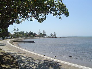
Wynnum is a coastal suburb in the City of Brisbane, Queensland, Australia. In the 2016 census, Wynnum had a population of 12,915 people. The suburb is a popular destination in Brisbane due to its coastline, jetty and tidal wading pool.

<span class="mw-page-title-main">Murarrie, Queensland</span> Suburb of Brisbane, Queensland, Australia

Murarrie is an eastern riverside mixed-use suburb in the City of Brisbane, Queensland, Australia. Queensport is a neighbourhood within Murarrie. Gibson Island is a neighbourhood within Murarrie and, despite its name, is no longer an island. In the 2021 census, Murarrie had a population of 4,946 people.

<span class="mw-page-title-main">Manly, Queensland</span> Suburb of Brisbane, Queensland, Australia

Manly is an eastern bayside suburb in the City of Brisbane, Queensland, Australia. In the 2016 census, Manly had a population of 4,064 people.

<span class="mw-page-title-main">Burbank, Queensland</span> Suburb of Brisbane, Queensland, Australia

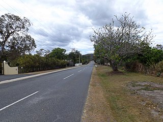
Burbank is a greenbelt suburb in the City of Brisbane, Queensland, Australia. In the 2016 census, Burbank had a population of 1,050 people.

<span class="mw-page-title-main">Northgate, Queensland</span> Suburb of Brisbane, Queensland, Australia

Northgate is a suburb in the City of Brisbane, Queensland, Australia. In the 2016 census, Northgate had a population of 4,568 people.

<span class="mw-page-title-main">Wynnum West, Queensland</span> Suburb of Brisbane, Queensland, Australia

Wynnum West and Lindum are outer eastern suburb in the City of Brisbane, Queensland, Australia. In the 2016 census, Wynnum West including the locality of Lindum had a population of 12,292 people.

<span class="mw-page-title-main">Chandler, Queensland</span> Suburb of Brisbane, Queensland, Australia

Chandler is an outer south-eastern suburb in the City of Brisbane, Queensland, Australia. In the 2016 census, Chandler had a population of 1,442 people.

<span class="mw-page-title-main">Lytton, Queensland</span> Suburb of Brisbane, Queensland, Australia

Lytton is an outer riverside suburb in the City of Brisbane, Queensland, Australia. In the 2016 census, Lytton had a population of 6 people.

<span class="mw-page-title-main">Belmont, Queensland</span> Suburb of Brisbane, Queensland, Australia

Belmont is an outer suburb in the City of Brisbane, Queensland, Australia. In the 2016 census, Belmont had a population of 4,374 people.

<span class="mw-page-title-main">Manly West, Queensland</span> Suburb of Brisbane, Queensland, Australia

Manly West is a suburb in the City of Brisbane, Queensland, Australia. In the 2016 census, Manly West had a population of 11,978 people.

<span class="mw-page-title-main">Lota, Queensland</span> Suburb of Brisbane, Queensland, Australia

Lota is an eastern bayside suburb in the City of Brisbane, Queensland, Australia. In the 2021 census, Lota had a population of 3,518 people.

<span class="mw-page-title-main">Hemmant, Queensland</span> Suburb of Brisbane, Queensland, Australia

Hemmant is a suburb of the City of Brisbane, Queensland, Australia. In the 2016 census, Hemmant had a population of 2,385 people.

<span class="mw-page-title-main">Cannon Hill, Queensland</span> Suburb of Brisbane, Queensland, Australia

Cannon Hill is a suburb in the City of Brisbane, Queensland, Australia. In the 2016 census, Cannon Hill had a population of 5,533 people.

<span class="mw-page-title-main">Ransome, Queensland</span> Suburb of Brisbane, Queensland, Australia

Ransome is an outer coastal suburb in the City of Brisbane, Queensland, Australia. In the 2016 census, Ransome had a population of 405 people.

<span class="mw-page-title-main">Sheldon, Queensland</span> Suburb of Redland City, Queensland, Australia

Sheldon is a rural residential locality in the City of Redland, Queensland, Australia. In the 2016 census, Sheldon had a population of 1,704 people.

<span class="mw-page-title-main">Town of Wynnum</span>

The Town of Wynnum is a former local government area of Queensland, Australia, located in eastern Brisbane adjacent to Moreton Bay around the present day suburb of Wynnum.

<span class="mw-page-title-main">Shire of Belmont</span> Former local government area in Queensland

The Shire of Belmont is a former local government area of Queensland, Australia, located in eastern Brisbane including the current suburb of Belmont.

References

  1. 1 2 3 Australian Bureau of Statistics (27 June 2017). "Gumdale (SSC)". 2016 Census QuickStats. Retrieved 20 October 2018. OOjs UI icon edit-ltr-progressive.svg
  2. "Chandler Ward". Brisbane City Council. Archived from the original on 4 February 2017. Retrieved 12 March 2017.
  3. 1 2 "Gumdale – suburb in City of Brisbane (entry 49249)". Queensland Place Names. Queensland Government . Retrieved 25 January 2020.
  4. "The Brisbane Courier". The Brisbane Courier . Vol. XXXIX, no. 8, 426. Queensland, Australia. 12 January 1885. p. 4. Archived from the original on 21 May 2022. Retrieved 30 July 2019 via National Library of Australia.
  5. "Grassdale Estate 2nd section" (c. 1880) [Map]. Collections. State Library of Queensland.
  6. "Advertising". Queensland Figaro And Punch . Vol. VI, no. 150. Queensland, Australia. 21 November 1885. p. 39. Archived from the original on 21 May 2022. Retrieved 30 July 2019 via National Library of Australia.
  7. "Commercial". The Telegraph . No. 4, 125. Queensland, Australia. 30 November 1885. p. 4. Archived from the original on 21 May 2022. Retrieved 30 July 2019 via National Library of Australia.
  8. "Plan of divisions of unsold land into 45 lots [between Old and New Cleveland Roads]" [Map]. Collections. State Library of Queensland.
  9. Queensland Family History Society (2010), Queensland schools past and present (Version 1.01 ed.), Queensland Family History Society, ISBN   978-1-921171-26-0
  10. "History". Department of Education, Training and Employment. Archived from the original on 9 March 2015. Retrieved 22 October 2014.
  11. "Grassdale Hall Built Without Borrowing". The Courier-mail . Queensland, Australia. 11 September 1937. p. 12. Archived from the original on 21 May 2022. Retrieved 15 March 2020 via Trove.
  12. "NUTSHELLS". The Courier-mail . Queensland, Australia. 3 July 1942. p. 3. Archived from the original on 21 May 2022. Retrieved 15 March 2020 via Trove.
  13. Anglican Church of Southern Queensland. "Closed Churches". Archived from the original on 3 April 2019. Retrieved 3 July 2020.
  14. "281 Tilley Road, Gumdale". Google Maps. Archived from the original on 7 July 2020. Retrieved 7 July 2020.
  15. 1 2 Australian Bureau of Statistics (31 October 2012). "Gumdale, Qld (State Suburb)". 2011 Census QuickStats. Retrieved 24 October 2013. OOjs UI icon edit-ltr-progressive.svg
  16. 1 2 "State and non-state school details". Queensland Government. 9 July 2018. Archived from the original on 21 November 2018. Retrieved 21 November 2018.
  17. "Gumdale State School". Archived from the original on 12 March 2020. Retrieved 21 November 2018.
  18. "ACARA School Profile 2017". Archived from the original on 22 November 2018. Retrieved 22 November 2018.
  19. "Queensland Globe". State of Queensland . Retrieved 14 March 2020.