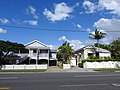
Kalinga, Queensland

Last updated

Kalinga
Brisbane,  Queensland
Memorial gates at Kalinga Park.jpg
Memorial gates at Kalinga Park
Australia Queensland location map.svg
Red pog.svg
Kalinga
Coordinates 27°24′34″S153°02′54″E / 27.4094°S 153.0483°E / -27.4094; 153.0483 (Kalinga (centre of suburb))
Population2,144 (SAL 2021) [1]
Postcode(s) 4030
Elevation10 m (33 ft)
Area0.9 km2 (0.3 sq mi)
Time zone AEST (UTC+10:00)
Location9.7 km (6 mi) NNE of Brisbane CBD
LGA(s) City of Brisbane (Hamilton Ward)
State electorate(s) Clayfield
Federal division(s) Brisbane
Suburbs around Kalinga:
Wavell Heights Nundah Nundah
Kedron Kalinga Clayfield
Kedron Wooloowin Clayfield

Kalinga is a suburb in the City of Brisbane, Queensland, Australia. [2] In the 2016 census, Kalinga had a population of 2,126 people. [3]

Contents

Geography

Kedron Brook, west from Shaw Road bridge, 2013 Kedron Brook W from Shaw Rd Kalinga.jpg
Kedron Brook, west from Shaw Road bridge, 2013

Kalinga is bounded by Kedron Brook to the north. [4] The Kedron Brook bikeway follows the brook on the suburb's north-east boundary with two bridges over the creek to Shaw Park in Wavell Heights ( 27°24′15″S153°02′59″E / 27.4041°S 153.0498°E / -27.4041; 153.0498 (Kedron Brook bikeway bridge to Shaw Park) ) and to Toombul Terrace in Nundah ( 27°24′29″S153°03′18″E / 27.4081°S 153.0549°E / -27.4081; 153.0549 (Kedron Brook bikeway bridge to Toombul Terrace) ). There is a third bridge over the creek ( 27°24′16″S153°03′03″E / 27.4045°S 153.0508°E / -27.4045; 153.0508 (Foot bridge to Carew & New Streets) ) from the bikeway (but not part of the bikeway) to Carew and New Street in Nundah. [5]

Kalinga is predominantly flat, approximately 10 metres (33 ft) above sea level. [4]

The M7 Airport Link passes under the suburb through a tunnel. [4]

The land use is predemoniantly residential with the remainder of the suburb being parks. [4] It has a mix of small apartment blocks and houses, with some older style Queenslanders still extant.[ citation needed ]

History

Real estate map of Kedron Park estate, 1888 Real estate map of Kedron Park estate, 1888 (25793072414).jpg
Real estate map of Kedron Park estate, 1888

The name Kalinga derives from Aboriginal word Ngalinnga ("ngalin-nga"), probably from the Yuggera language, Turrbal dialect, meaning belonging to us. [2]

This area is notable for the original residence of Alfred Lutwyche, known as Kedron Lodge. [6]

On Saturday 8 October 1888, auctioneers Arthur Martin and Co offered 220 allotments for sale in the Kedron Park Estate, formerly part of the land owned by the then late Justice Alfred Lutwyche and in the vicinity of Park Road, Judge Road and Station Road. [7]

Advertising for Kalinga Theatre, 1956 Movie flyer from Kalinga Theatre for movie "Lilacs in the Spring", August 1956.jpg
Advertising for Kalinga Theatre, 1956

An open air-movie theatre opened circa 1920 at 70 Lodge Street ( 27°24′38″S153°02′51″E / 27.4105°S 153.0476°E / -27.4105; 153.0476 (Kalinga Picture Palace) ). It was enclosed circa 1929. It seated 400 to 500 people. It was variously known as the Kalinga Picture Palace, Kalinga Picture Theatre Kalinga Theatre and the Star Theatre. It burned down in the early 1960s and a Mobil petrol station was built on the site. [8]

Opening Ceremony, Kalinga Park Memorial Gates, 23 October 1920 Kalinga Park Honour Gates - Day of Opening Ceremony.jpg
Opening Ceremony, Kalinga Park Memorial Gates, 23 October 1920

On Saturday 23 October 1920, Brigadier-General L.C. Wilson officially opened the war memorial gates at Kalinga Park at the end of Park Street ( 27°24′28″S153°03′07″E / 27.4078°S 153.0519°E / -27.4078; 153.0519 (Memorial Gates) ) to commemorate the service of local men in World War I. Between 200 and 300 people attended the ceremony. The gates were designed by Andrew Lang Petrie who also did the carving of the Helidon sandstone while the steelwork was done by Mr Rodgers. [9]

Between 1927 and 1962, an electric tram service operated by the Brisbane City Council served the suburb, branching off the Chermside line at Kedron Park Road.

On Sunday 5 February 1928, a Presbyterian Hall was opened in Kalinga by Moderator W.C. Radcliffe. [10]

On Sunday 23 July 1933, Archbishop James Duhig officially blessed and opened Kedron Lodge as a temporary Catholic Church. [11]

On 25 November 1934, Duhig blessed and laid the foundation stone for the new St Anne's Catholic Church. [12] On Sunday 19 May 1935 Duhig opened and dedicated the church, designed in the Spanish style and could accommodate 500 people. [13] On Sunday 1 August 1937 Duhig blessed and opened the adjoining presbytery. [14]

The Kalinga Scout group was formed in 1938. It now occupies the post office of the 17th Australian Personnel Staging Camp in Kalinga Park during World War II. [15]

St Anne's Catholic School opened in February 1948 and closed in 1966. [16]

Caravan made from a converted aircraft, 1950 Caravan made from a converted DC-4, Kalinga, 1950.jpg
Caravan made from a converted aircraft, 1950

In 1950 mechanic Henry William Endres of 51 Kent Street constructed a caravan from a disused aircraft. It was 37 feet (11 m) long and contained two bedrooms, a bathroom and kitchen. [17]

In 1983, the Presbyterian Church and Hall in Emma Street were purchased by the Presbyterian Church of Eastern Australia (a separate Presbyterian denomination) as their Brisbane church. [18]

The name Kalinga had been in use for the area for many years as a neighbourhood within the suburb of Wooloowin, but it was not until 16 October 2015 that Kalinga was officially gazetted as a suburb, having been excised from Wooloowin following requests from local residents. [2] [19] [20]

Demographics

Historical population
YearPop.±%
20162,126    
20212,144+0.8%

In the 2016 census, Kalinga had a population of 2,126 people, 49% identifying as male and 51% identifying as female. The median age was 38 years of age, one year above the Queensland median and equal to the Australian median. Children aged under 15 years made up 23.5% of the population and people aged 65 years and over made up 12.3% of the population. 73.2% of people living in Kalinga were born in Australia, compared to the national average of 66.7%. The other top responses for country of birth were England 4.3%, New Zealand 3.8%, India 1.4%, South Africa 1.2% and Philippines 0.8%. 84.7% of people only spoke English at home. Other languages spoken at home included Italian 1.0%, French 0.8%, Polish 0.6%, Punjabi 0.6% and Mandarin 0.6%. The most common responses for religion in Kalinga were Catholic 31.7%, No Religion, so described 27.1%, Anglican 15.1%, Not stated 8.9% and Uniting Church 4.9%. [3]

In the 2021 census, Kalinga had a population of 2,144 people, 48.6% identifying as male and 51.4% identifying as female. The median age was 39 years of age, one year above both the Queensland and Australian median. 76.9% of people living in Kalinga were born in Australia, compared to the national average of 66.9%. The other top responses for country of birth were England 4.6%, New Zealand 3.5%, South Africa 0.9%, Philippines 0.8%, United States of America 0.8%. 88.9% of people only spoke English at home. Other languages spoken at home included Italian 1.1%, Japanese 0.6%, Dutch 0.5%, Thai 0.5% and Mandarin 0.4%. The most common responses for religion in Kalinga were No Religion, so described 36.7%, Catholic 31.4%, Anglican 11.7%, Not stated 5.2% and Uniting Church 4.2%. [21]

Heritage listings

Kedron Lodge, 2008 Kedron Lodge Queensland.gjm.JPG
Kedron Lodge, 2008

Kalinga has a number of heritage-listed sites, including:

Amenities

Kalinga Presbyterian Church, 2013 Kalinga presb church shaw 1.jpg
Kalinga Presbyterian Church, 2013

St Anne's Catholic Church is at 127 Nelson Street ( 27°24′32″S153°02′39″E / 27.4089°S 153.0441°E / -27.4089; 153.0441 (St Anne's Catholic Church) ). [23]

Wooloowin Presbyterian Church (formerly the Kalinga Presbyterian Church) is at 78 Emma Street ( 27°24′31″S153°02′51″E / 27.4087°S 153.0474°E / -27.4087; 153.0474 (Wooloowin Presbyterian Church of Eastern Australia) ). It is the only church in Queensland of the Presbyterian Church of Eastern Australia. [24] [18] [25]

There are a number of parks in the area:

Kalinga Bowls Club is located within Melrose Park ( 27°24′43″S153°02′46″E / 27.4119°S 153.0460°E / -27.4119; 153.0460 (Kalinga Bowls Club) ). [26] [24]

Kalinga Scouts have their hall in Kalinga Park near the Bertha Street entrance ( 27°24′22″S153°03′00″E / 27.4060°S 153.0501°E / -27.4060; 153.0501 (Kalinga Scouts) ). [15]

Education

There are no schools in Kalinga. The nearest state primary schools are Eagle Junction State School in neighbouring Clayfield to the south-east and Wooloowin State School in neighbouring Wooloowin to the south-west. The nearest state secondary school is Kedron State High School immediately over the boundary to neighbouring Kedron to the south-west. [28] Clayfield College is a popular nearby private school option covering both primary and secondary education. [4]

Notable residents

Related Research Articles

<span class="mw-page-title-main">Albion, Queensland</span> Suburb of Brisbane, Queensland, Australia

Albion is an inner north-eastern suburb in the City of Brisbane, Queensland, Australia. In the 2021 census, Albion had a population of 3,446 people.

<span class="mw-page-title-main">Aspley, Queensland</span> Suburb of Brisbane, Queensland, Australia

Aspley is a suburb in the City of Brisbane, Queensland, Australia. In the 2021 census, Aspley had a population of 12,871 people.

<span class="mw-page-title-main">Gordon Park, Queensland</span> Suburb of Brisbane, Queensland, Australia

Gordon Park is a northern suburb in the City of Brisbane, Queensland, Australia. In the 2021 census, Gordon Park had a population of 4,390 people.

<span class="mw-page-title-main">Wooloowin, Queensland</span> Suburb of Brisbane, Queensland, Australia

Wooloowin is a suburb in the City of Brisbane, Queensland, Australia. In the 2021 census, Wooloowin had a population of 4,029 people.

<span class="mw-page-title-main">South Brisbane, Queensland</span> Suburb of Brisbane, Queensland, Australia

South Brisbane is an inner southern suburb in the City of Brisbane, Queensland, Australia. In the 2021 census, South Brisbane had a population of 14,292 people.

<span class="mw-page-title-main">Mitchelton, Queensland</span> Suburb of Brisbane, Queensland, Australia

Mitchelton is a north-western suburb in the City of Brisbane, Queensland, Australia. In the 2021 census, Mitchelton had a population of 9,244 people.

<span class="mw-page-title-main">Clayfield, Queensland</span> Suburb of Brisbane, Queensland, Australia

Clayfield is a suburb in the City of Brisbane, Queensland, Australia. In the 2021 census, Clayfield had a population of 10,897 people.

<span class="mw-page-title-main">Lutwyche, Queensland</span> Suburb of Brisbane, Queensland, Australia

Lutwyche is a northern suburb in the City of Brisbane, Queensland, Australia. In the 2021 census, Lutwyche had a population of 4,610 people.

<span class="mw-page-title-main">Kedron, Queensland</span> Suburb of Brisbane, Queensland, Australia

Kedron is a northern suburb in the City of Brisbane, Queensland, Australia. It is home to the Queensland Fire and Emergency Services headquarters. In the 2021 census, Kedron had a population of 9,907 people.

<span class="mw-page-title-main">Windsor, Queensland</span> Suburb of Brisbane, Queensland, Australia

Windsor is an inner northern suburb in the City of Brisbane, Queensland, Australia. In the 2021 census, Windsor had a population of 7,811 people.

<span class="mw-page-title-main">Chermside West, Queensland</span> Suburb of Brisbane, Queensland, Australia

Chermside West is a suburb in the City of Brisbane, Queensland, Australia. In the 2021 census, Chermside West had a population of 6,965 people. Parts of Chermside West were formerly known as Craigslea.

<span class="mw-page-title-main">Nundah, Queensland</span> Suburb of Brisbane, Queensland, Australia

Nundah is an inner suburb in the City of Brisbane, Queensland, Australia. It contains the neighbourhood of Toombul. In the 2021 census, Nundah had a population of 13,098 people.

<span class="mw-page-title-main">Wavell Heights, Queensland</span> Suburb of Brisbane, Queensland, Australia

Wavell Heights is a suburb in the City of Brisbane, Queensland, Australia. In the 2021 census, Wavell Heights had a population of 10,336 people.

<span class="mw-page-title-main">Stafford, Queensland</span> Suburb of Brisbane, Queensland, Australia

Stafford is a northern suburb in the City of Brisbane, Queensland, Australia. In the 2021 census, Stafford had a population of 6,978 people.

<span class="mw-page-title-main">Hendra, Queensland</span> Suburb of Brisbane, Queensland, Australia

Hendra is a suburb of the City of Brisbane, Queensland, Australia. In the 2021 census, Hendra had a population of 4,914 people.

<span class="mw-page-title-main">Everton Park, Queensland</span> Suburb of Brisbane, Queensland, Australia

Everton Park is a northern suburb of the City of Brisbane, Queensland, Australia. In the 2021 census, Everton Park had a population of 10,111 people.

<span class="mw-page-title-main">Wilston, Queensland</span> Suburb of Brisbane, Australia

Wilston is a northern suburb in the City of Brisbane, Queensland, Australia. In the 2021 census, Wilston had a population of 4,110 people.

<span class="mw-page-title-main">Grange, Queensland</span> Suburb of Brisbane, Queensland, Australia

Grange is a northern suburb in the City of Brisbane, Queensland, Australia. In the 2021 census, Grange had a population of 4,615 people.

<span class="mw-page-title-main">Hamilton, Queensland</span> Suburb of Brisbane, Queensland, Australia

Hamilton is an affluent riverside mixed-use suburb in the north-east of the City of Brisbane, Queensland, Australia. Hamilton is located along the north bank of the Brisbane River. In the 2021 census, Hamilton had a population of 8,922 people.

<span class="mw-page-title-main">Kedron Brook</span> River in Queensland, Australia

The Kedron Brook is a creek that flows through the northern suburbs of Brisbane in the south-east region of Queensland, Australia.

References

  1. Australian Bureau of Statistics (28 June 2022). "Kalinga (suburb and locality)". Australian Census 2021 QuickStats. Retrieved 28 June 2022.  OOjs UI icon edit-ltr-progressive.svg
  2. 1 2 3 "Kalinga – suburb in City of Brisbane (entry 49667)". Queensland Place Names. Queensland Government . Retrieved 11 December 2020.
  3. 1 2 Australian Bureau of Statistics (27 June 2017). "Kalinga (SSC)". 2016 Census QuickStats. Retrieved 2 June 2024. OOjs UI icon edit-ltr-progressive.svg
  4. 1 2 3 4 5 "Queensland Globe". State of Queensland . Retrieved 11 December 2020.
  5. "Foot bridges - Queensland". Queensland Open Data. Queensland Government. 22 October 2020. Archived from the original on 16 November 2020. Retrieved 3 November 2020.
  6. 1 2 "Kedron Lodge (entry 600238)". Queensland Heritage Register . Queensland Heritage Council. Retrieved 19 June 2013.
  7. "Advertising". Queensland Figaro And Punch . Vol. XII, no. 291. Queensland, Australia. 1 September 1888. p. 23. Archived from the original on 11 December 2020. Retrieved 11 December 2020 via National Library of Australia.
  8. "The Star Theatre (Kalinga)" (PDF). Australian Variety Theatre Archive. 18 March 2020. Archived (PDF) from the original on 11 December 2020. Retrieved 11 December 2020.
  9. "Honour to the Brave". The Telegraph . No. 14, 949. Queensland, Australia. 25 October 1920. p. 10 (Second Edition). Archived from the original on 11 December 2020. Retrieved 11 December 2020 via National Library of Australia.
  10. "Untitled". The Brisbane Courier . No. 21, 850. Queensland, Australia. 6 February 1928. p. 18. Archived from the original on 11 December 2020. Retrieved 11 December 2020 via National Library of Australia.
  11. "Church Development". Daily Mercury . Vol. 67, no. 173. Queensland, Australia. 24 July 1933. p. 6. Archived from the original on 11 December 2020. Retrieved 11 December 2020 via National Library of Australia.
  12. "New Church at Kalinga". The Catholic Press . No. 2029. New South Wales, Australia. 6 December 1934. p. 49. Archived from the original on 11 December 2020. Retrieved 11 December 2020 via National Library of Australia.
  13. "Kalinga's New Church". The Courier-mail . No. 537. Queensland, Australia. 20 May 1935. p. 15. Archived from the original on 11 December 2020. Retrieved 11 December 2020 via National Library of Australia.
  14. "New Presbytery at Kalinga". The Courier-mail . No. 1223. Queensland, Australia. 2 August 1937. p. 21. Archived from the original on 11 December 2020. Retrieved 11 December 2020 via National Library of Australia.
  15. 1 2 "About Us - Kalinga Cubs & Scouts". Kalinga Scouts. Archived from the original on 11 December 2020. Retrieved 11 December 2020.
  16. Queensland Family History Society (2010), Queensland schools past and present (Version 1.01 ed.), Queensland Family History Society, ISBN   978-1-921171-26-0
  17. "Caravan From Plane". Brisbane Telegraph . Queensland, Australia. 20 November 1950. p. 11 (City Final). Archived from the original on 11 December 2020. Retrieved 11 December 2020 via National Library of Australia.
  18. 1 2 "Presbyterian Church of Eastern Australia - Wooloowin | Churches Australia". Churches Australia. Archived from the original on 11 December 2020. Retrieved 11 December 2020.
  19. "Minutes of the meeting of the Kalinga Wooloowin Residents' Association held on Thursday, 29 August at the Kalinga Bowls Club" (PDF). Kalinga Wooloowin Residents' Association. Archived (PDF) from the original on 15 March 2014. Retrieved 15 March 2014.
  20. "Proposal: Discontinue the unbounded locality of Kalinga and to alter the boundaries of the suburbs of Wooloowin and Clayfield to create the new suburb of Kalinga". Queensland Government. Archived from the original on 27 May 2015. Retrieved 27 May 2015.
  21. Australian Bureau of Statistics (28 June 2022). "Kalinga (SAL)". 2021 Census QuickStats. Retrieved 2 June 2024. OOjs UI icon edit-ltr-progressive.svg
  22. "Kalinga Park (entry 602584)". Queensland Heritage Register . Queensland Heritage Council. Retrieved 19 June 2013.
  23. "St Anne's Church, Kalinga (Wooloowin)". Roman Catholic Archdiocese of Brisbane . Archived from the original on 11 December 2020. Retrieved 11 December 2020.
  24. 1 2 "Building points - Queensland". Queensland Open Data. Queensland Government. 17 November 2020. Archived from the original on 25 November 2020. Retrieved 25 November 2020.
  25. "Brisbane Presbyterian Church of Eastern Australia". Presbyterian Church of Eastern Australia . Archived from the original on 11 December 2020. Retrieved 11 December 2020.
  26. 1 2 3 4 5 6 7 8 "Kalinga parks". Brisbane City Council . Archived from the original on 11 December 2020. Retrieved 11 December 2020.
  27. 1 2 3 4 5 "Land for public recreation - Queensland". Queensland Open Data. Queensland Government. 20 November 2020. Archived from the original on 22 November 2020. Retrieved 22 November 2020.
  28. "Queensland Government EdMap". EdMap. Retrieved 2 June 2024.