Electoral district of Nudgee

Last updated

Nudgee
QueenslandLegislative Assembly
ECQ-2017-Final-Nudgee.pdf
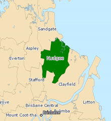
Electoral map of Nudgee 2017
State Queensland
Dates current1960–present
MP Leanne Linard
Party Labor
Namesake Nudgee
Electors 37,845 (2020)
Area42 km2 (16.2 sq mi)
DemographicOuter-metropolitan
Coordinates 27°22′S153°4′E / 27.367°S 153.067°E / -27.367; 153.067
Electorates around Nudgee:
Sandgate Sandgate Moreton Bay
Aspley Nudgee Clayfield
Stafford Clayfield Clayfield
Electoral map of Nudgee 2008 QLD - Nudgee 2008.png
Electoral map of Nudgee 2008

Nudgee is an electoral district of the Legislative Assembly in the Australian state of Queensland. It is located in the north-eastern suburbs of Brisbane. [1]

Contents

Members for Nudgee

MemberPartyTerm
  Jack Melloy Labor 1960–1977
  Ken Vaughan Labor 1977–1995
  Neil Roberts Labor 1995–2012
  Jason Woodforth Liberal National 2012–2015
  Leanne Linard Labor 2015–present

Election results

2024 Queensland state election: Nudgee [2]
PartyCandidateVotes%±%
Labor Leanne Linard 16,86048.20−3.30
Liberal National Robert Wilson11,13731.84+1.84
Greens Jim Davies4,72113.50+0.30
One Nation Joshua Baer1,2483.57+0.07
Family First Sharan Hall5911.69+1.69
Independent Bruce Tanti4191.20+1.20
Total formal votes34,97697.08
Informal votes1,0532.92
Turnout 36,02989.80
Two-party-preferred result
Labor Leanne Linard 21,68662.00−3.10
Liberal National Robert Wilson13,29038.00+3.10
Labor hold Swing -3.10

References

  1. "Representatives of Queensland State Electorates 1860-2017" (PDF). Queensland Parliamentary Record 2012-2017: The 55th Parliament. Queensland Parliament. Archived from the original (PDF) on 27 April 2020.
  2. "Nudgee - QLD Electorate, Candidates, Results". abc.net.au. 27 October 2024. Retrieved 14 December 2024.