Eastern Australian temperate forests

Last updated

Eastern Australian temperate forests
NewEnglandNP.jpg
Ecoregion AA0402.png
Ecoregion territory (in purple)
Ecology
Biome Temperate broadleaf and mixed forests
Borders
Bird species380 [1]
Mammal species87 [1]
Geography
Area222,100 km2 (85,800 sq mi)
Country Australia
States
Conservation
Habitat loss32.821% [1]
Protected16.55% [1]

The Eastern Australian temperate forests is a broad ecoregion of open forest on uplands (typically on the Great Dividing Range) starting from the east coast of New South Wales in the South Coast to southern Queensland, Australia. Although dry sclerophyll and wet sclerophyll eucalyptus forests predominate within this ecoregion, [2] [3] a number of distinguishable rainforest communities are present as well. [4] [5]

Contents

Many systematic National and State Parks are distributed throughout New South Wales and Queensland, although the representation of habitats varies throughout the ecoregion. In some areas, eucalyptus woodlands and dry forests have been cleared for urban development or to enhance grazing. Before Europeans first arrived to Australia, the Border Ranges had one of the largest rainforests in Australia. [6]

Geography

This ecoregion covers an area between Australia's east coast and the Great Dividing Range, starting just above Eden, New South Wales in the South Coast, which includes (parts of) the Blue Mountains to the west Sydney, and ending in south Queensland's Border Ranges. [7] The Sydney metropolitan area is transitional with regions such as the greater west (or the Cumberland Plain Woodland) being virtually excluded from this biome since it predominantly contains dry sclerophyll, grassy woodlands and thus the region's vegetation community will be more similar to Temperate grasslands (i.e. savannahs). [8] [9] Though pockets of forested areas in Sydney, such as those in The Hills Shire to the north and Sutherland Shire to the south, which are relatively wet, do have regions within them that are part of Eastern Australian temperate forests (such as the Sydney Turpentine-Ironbark Forest and Blue Gum High Forest). [10] [11] [12]

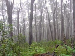
Eucalyptus communities meandering the coast in southern Queensland and northern New South Wales are usually wet sclerophyll wet forests, ranging from 30 percent to 70 percent closed canopy cover, with the understorey containing small broadleaved trees, vines, ferns and shrubs. Both wet and dry sclerophyll forests are the most predominant vegetation communities in the coastal corridor of south-eastern Australia, and would receive less rainfall than the rainforest communities.

Subtropical rainforest are complex closed-forests that are the most developed community in New South Wales, growing in warm, fecund sites having rainfall higher than 1,300 mm per year. They are predominantly found between the border of Queensland and New South Wales, near the Gold Coast, Coffs Harbour and Byron Bay. [13] [14] [15]

Dry rainforests are low closed forests with irregular canopy that occur in sites with lower rainfall, ranging from 600 mm to 1,100 mm annual rainfall, generally in parts of the Blue Mountains and also near Narooma and Moruya in the south coast. Dry rainforest was distributed in southeastern Queensland where it occupied about half a million hectares, though it has now been broadly cleared for agriculture. There is a small dry rainforest community in southwestern Sydney, near Abbotsbury. [16] [14] [15] Western Vine Thickets, another dry closed forest biome is found inland of New South Wales near Moree and Narrabri. [17]

Warm temperate rainforest are closed forests with far less diversity than the dry or subtropical rainforests, growing on low-nutrient soils. It is found scattered in the Blue Mountains, Central Coast, North Coast, the Illawarra escarpment near Wollongong and in isolated pockets in the South Coast. [18] [14] [15] Cool temperate forests are found in the highlands in the northern areas of New South Wales. [19] [14] [15] The Blue Mountains and Southern Highlands Basalt Forests and the Illawarra-Shoalhaven subtropical rainforest are a prominent forest community within the ecoregion. [20]

The rainforest communities of this region exhibit ecological relations to other regions: the cool temperate rainforest is similar to the biome found in Tasmania, the warm temperate rainforest has links to the North Island of New Zealand, and the subtropical and dry regions are also found up north in the Queensland tropical rain forests ecoregion. The Blue Mountains area has over 90 eucalypt taxa, or 13% of the global dispersion. [21]

Biome groupings

The ecoregion has a variety of vegetation communities in its scope:

To note, the open eucalypt forest is a broad, crescent-shaped vegetation community that is found from Gladstone, Queensland to as far as Quorn, South Australia in the southwest, which incorporates Southeast Australia temperate forests in southern Victoria and the Mediterranean woodlands in western Victoria and eastern South Australia. [22]

Climate

These are areas of eucalyptus forest on sandstone plateau, with smaller sections of cliffs, steep gorges with rainforest vegetation and sandy heath on the coasts. The climate is oceanic to the south and humid subtropical to the north. In the central areas of the Blue Mountains, rainfall averages from 1,100 to 1,400 mm annually. Climate in the coastal regions is humid, with excessive rainfall (1200 mm to 1600 mm a year). Rainfall decreases as one moves inland to the New England region with Armidale receiving around 800 mm of rain each year on average. Winters in that city are cold and wet and higher elevations receive snowfall most years. [23]

Further north in the Border Ranges, monthly summer temperatures vary from 21.5C maximum to 19.7C minimum. Corresponding winter temperatures from Mount Tamborine in the Border Ranges vary from 17.8C maximum to 12.3C minimum. Throughout the ecoregion, rainfall is concentrated in the summer. Towards the north of the ecoregion rainfall is lower (750 mm to 1100 mm per year) and more seasonal.

Flora

Brisbane Water National Park in the Central Coast near Gosford, New South Wales. Brisbane Waters National Park (13813818344).jpg
Brisbane Water National Park in the Central Coast near Gosford, New South Wales.

The dominant forest is peppermint eucalyptus trees, indeed it was the moisture from these trees which was originally thought to cause the blue mist that gave the mountains their name. Shrublands, shrubby woodlands (heaths), and affiliated sandplain vegetation are typical of the region's coastal area. The shrub species include, Epacridaceae, Myrtaceae, Rutaceae, Fabaceae, Proteaceae, and Cyperaceae. The Border Ranges is home to more than 1,200 vascular plants.

A variety of eucalyptus trees dominate areas of this large ecoregion, including: in southern Queensland and northern New South Wales (such as in around such as the Northern Tablelands) - tallowwood ( Eucalyptus microcorys ), blackbutt ( Eucalyptus pilularis ), brush box ( Lophostemon confertus ), flooded gum ( Eucalyptus grandis ), and Gympie messmate ( Eucalyptus cloeziana ); southern New South Wales - Sydney blue gum ( Eucalyptus saligna ), the grey ironbark ( Eucalyptus paniculata ), and blackbutt; and on the New South Wales coast a stringybark (Eucalyptus eugenioides). Trees in the warm temperate forests include coachwood ( Ceratopetalum apetalum ), sassafras ( Doryphora sassafras ), and lillypilly ( Acmena smithii ) Typical trees in cool temperate forests include Eucryphia moorei and Antarctic beech (Nothofagus moorei). [24]

There are particularly rich collections of endemic plants in a number of areas: the eucalyptus of the Blue Mountains; the rainforests of Border Ranges area in the McPherson Range including Mount Warning, Nightcap National Park, and Lamington National Park including Binna Burra; and the sand dunes of World Heritage Site Fraser Island and the Great Sandy National Park of southern Queensland. There are well-known areas of rainforest protected as the Gondwana Rainforests of Australia, containing distinct areas of subtropical rainforest in New South Wales, dry rainforest of southern Queensland (although most of this has been cleared for agriculture and pine plantations) and warm temperate rainforest south of Sydney. Finally the coasts are covered with shrubs, heath and other sand dune vegetation. [25]

Fauna

Local wildlife includes velvet worms and koalas, while the birds of the forest include kookaburra kingfishers, gang-gang cockatoos, crimson rosellas and striated thornbills and a number of threatened birds including red goshawk (Erythrotriorchis radiatus), swift parrot (Lathamus discolor), regent honeyeater (Xanthomyza phrygia), Albert's lyrebird (Menura alberti), and eastern bristlebird (Dasyornis brachypterus). Overall , upwards of 60 reptiles, 65 mammals, and 275 birds have been transcribed in the Blue Mountains. The broad-headed snake and the stuttering frog also exist in the region. [26]

List of national parks within the ecoregion

A stream in Werrikimbe National Park in the Mid North Coast of NSW. Werrikimbe NP.jpg
A stream in Werrikimbe National Park in the Mid North Coast of NSW.
Misty Deua Forest in the South Coast NSW, near Batemans Bay. Deua forest with mist.JPG
Misty Deua Forest in the South Coast NSW, near Batemans Bay.

These parks are listed in a north to south order, starting from northern NSW down to the south coast of NSW (to note, not all plant communities within these parks have temperate forests, as some would grade to Mediterranean woodlands and/or subtropical forests, depending on the vicinity):

See also

Related Research Articles

<span class="mw-page-title-main">Brisbane Water National Park</span> Protected area in New South Wales, Australia

<span class="mw-page-title-main">New England National Park</span> Protected area in New South Wales, Australia

The New England National Park is a protected national park located on the Northern Tablelands in the New England region of New South Wales, Australia. The 67,303-hectare (166,310-acre) park was created in May 1935 and is situated approximately 560 kilometres (350 mi) north of Sydney, and 10 kilometres (6.2 mi) south of Waterfall Way, just 85 kilometres (53 mi) east of Armidale and 65 kilometres (40 mi) west of Coffs Harbour. The closest village to New England National Park is Ebor, located 20 kilometres (12 mi) away.

<span class="mw-page-title-main">Nightcap National Park</span> Protected area in New South Wales, Australia

The Nightcap National Park is a national park situated within the Nightcap Range in the Northern Rivers region of New South Wales, Australia. The 8,080-hectare (20,000-acre) park was created in April 1983 and is situated 35 kilometres (22 mi) north of Lismore. The national park is classed by the IUCN World Commission on Protected Areas as Category II and is part of the Shield Volcano Group of the World Heritage Site Gondwana Rainforests of Australia inscribed in 1986 and added to the Australian National Heritage List in 2007.

<span class="mw-page-title-main">Sclerophyll</span> Type of plant

Sclerophyll is a type of vegetation that is adapted to long periods of dryness and heat. The plants feature hard leaves, short internodes and leaf orientation which is parallel or oblique to direct sunlight. The word comes from the Greek sklēros (hard) and phyllon (leaf). The term was coined by A.F.W. Schimper in 1898, originally as a synonym of xeromorph, but the two words were later differentiated.

<span class="mw-page-title-main">Temperate rainforest</span> Forests in the temperate zone

Temperate rainforests are rainforests with coniferous or broadleaf forests that occur in the temperate zone and receive heavy rain.

<span class="mw-page-title-main">Illawarra</span> Region in New South Wales, Australia

The Illawarra is a coastal region in the Australian state of New South Wales, nestled between the mountains and the sea. It is situated immediately south of Sydney and north of the South Coast region. It encompasses the two cities of Wollongong, Shellharbour and the coastal town of Kiama. Wollongong is the largest city of the Illawarra with a population of 240,000, then Shellharbour with a population of 70,000 and Kiama with a population of 10,000. These three cities have their own suburbs. Wollongong stretches from Otford in the north to Windang in the south, with Maddens Plains and Cordeaux in the west.

<span class="mw-page-title-main">Geography of Sydney</span> Overview of the geography of Sydney

The geography of Sydney is characterised by its coastal location on a basin bordered by the Pacific Ocean to the east, the Blue Mountains to the west, the Hawkesbury River to the north and the Woronora Plateau to the south. Sydney lies on a submergent coastline on the east coast of New South Wales, where the ocean level has risen to flood deep river valleys (rias) carved in the Sydney sandstone. Port Jackson, better known as Sydney Harbour, is one such ria.

<span class="mw-page-title-main">Cumberland Plain</span> Plain in Australia

The Cumberland Plain, an IBRA biogeographic region, is a relatively flat region lying to the west of Sydney CBD in New South Wales, Australia. Cumberland Basin is the preferred physiographic and geological term for the low-lying plain of the Permian-Triassic Sydney Basin found between Sydney and the Blue Mountains, and it is a structural sub-basin of the Sydney Basin.

<span class="mw-page-title-main">Numinbah Nature Reserve</span> Protected area in New South Wales, Australia

Numinbah Nature Reserve is a protected nature reserve that is located in the Northern Rivers region of New South Wales, in eastern Australia. The reserve was gazetted in December 1981 with a further addition made in 1989 to make the reserve to its current area of 858 hectares. The reserve is situated north-east of the rural locality of Numinbah, and south of the Queensland town of Springbrook and defines part of the state border between New South Wales and Queensland.

<span class="mw-page-title-main">Southeast Australia temperate savanna</span>

The Southeast Australia temperate savanna ecoregion is a large area of grassland dotted with eucalyptus trees running north–south across central New South Wales, Australia.

<span class="mw-page-title-main">Garawarra State Conservation Area</span> Protected area in New South Wales, Australia

The Garawarra State Conservation Area is a protected conservation area that is located on the southern suburban fringe of Greater Sydney, in the state of New South Wales, in eastern Australia. The 949-hectare (2,350-acre) reserve abuts the Royal National Park and is situated 40 kilometres (25 mi) south of the Sydney central business district, near Helensburgh. Garawarra was gazetted as a park in 1987, and added, together with the Royal National Park, to the Australian National Heritage List on 15 September 2006.

Tasmania can be broadly divided into two distinct regions, eastern and western, that exhibit major differences in climate, geology and vegetation. This divide, termed Tyler’s Corridor, runs from just south of the northwestern corner, and continues south, cutting roughly down the center of the island. The vegetation changes occur principally due to variations in soil types, which are a result of the geological composition, and the vast difference in climate across the state. Generally, the west has a higher mean rainfall but poor acidic soil while the east has a lower mean rainfall but slightly more fertile soil. This results in a larger proportion of rainforest, moorland and wet sclerophyll vegetation dominating in the west and predominantly dry sclerophyll in the east.

<span class="mw-page-title-main">Cumberland Plain Woodland</span> Indigenous woodland community in Sydney, Australia

The Cumberland Plain Woodland, also known as Cumberland Plain Bushland and Western Sydney woodland, is a grassy woodland community found predominantly in Western Sydney, New South Wales, Australia, that comprises an open tree canopy, a groundcover with grasses and herbs, usually with layers of shrubs and/or small trees.

<span class="mw-page-title-main">Ecology of Sydney</span> Geographic aspect of Sydney, Australia

The ecology of Sydney, located in the state of New South Wales, Australia, is diverse for its size, where it would mainly feature biomes such as grassy woodlands or savannas and some sclerophyll forests, with some pockets of mallee shrublands, riparian forests, heathlands, and wetlands, in addition to small temperate rainforest fragments.

<span class="mw-page-title-main">Southeast Australia temperate forests</span> Terrestrial ecoregion in Australia

The Southeast Australia temperate forests is a temperate broadleaf and mixed forests ecoregion of south-eastern Australia. It includes the temperate lowland forests of southeastern Australia, at the southern end of the Great Dividing Range. Vegetation ranges from wet forests along the coast to dry forests and woodlands inland.

<span class="mw-page-title-main">Tasmanian temperate forests</span> Ecoregion in Tasmania, Australia

The Tasmanian temperate forests is a temperate broadleaf and mixed forests ecoregion in Australia. The ecoregion occupies the eastern portion of the island of Tasmania, which lies south of the Australian mainland.

<span class="mw-page-title-main">Southern Highlands Shale Forest and Woodland</span> Ecological community in New South Wales

The Southern Highlands Shale Forest and Woodland is a mixed grassy woodland and sclerophyll-temperate forest community situated within the Southern Highlands region of New South Wales, Australia. An ecotone featuring clay soils derived from Wianamatta Group, it is listed as an endangered ecological community by the Environment Protection and Biodiversity Conservation Act 1999 as less than 5% of the original extent remains today. Three varieties of the Shale Woodland exist: ‘typical’, ‘tall wet’ and ‘short dry’.

<span class="mw-page-title-main">Blue Mountains and Southern Highlands Basalt Forests</span> Ecological community in New South Wales

The Blue Mountains and Southern Highlands Basalt Forests are a sclerophyll temperate forest community that stretch from the northern fringes of the Blue Mountains to the Southern Highlands. Featuring both wet and dry sclerophyll forests, as well as small rainforest pockets, the community features tall (30m+) and open eucalypt forests and woodlands that lie on igneous rock.

<span class="mw-page-title-main">Rainforests and vine thickets</span>

Rainforests and vine thickets are a major vegetation group in Australia. It consists of temperate to tropical rainforests, monsoon forests, and vine thickets. Rainforests and vine thickets are generally found in small pockets across the eastern and northern portions of the continent, including western Tasmania, eastern New South Wales, eastern Queensland, the northern portion of the Northern Territory, and the Kimberley Region of northeastern Western Australia.

References

  1. 1 2 3 4 Hoekstra, J. M.; Molnar, J. L.; Jennings, M.; Revenga, C.; Spalding, M. D.; Boucher, T. M.; Robertson, J. C.; Heibel, T. J.; Ellison, K. (2010). Molnar, J. L. (ed.). The Atlas of Global Conservation: Changes, Challenges, and Opportunities to Make a Difference . University of California Press. ISBN   978-0-520-26256-0.
  2. "Dry sclerophyll forests (shrubby sub-formation)". NSW Environment & Heritage. Retrieved 15 March 2021.
  3. "Wet sclerophyll forests (grassy sub-formation)". NSW Environment & Heritage. Retrieved 15 March 2021.
  4. Ashton, D.H. and P.M. Attiwill. 1994. Tall open-forests. Pages 157 – 196 in R.H. Groves, editor. Australian Vegetation. Cambridge University Press, Cambridge, United Kingdom.
  5. Rainforests by the Office of Environment & Heritage
  6. Thackway, R., and I.D. Cresswell. editors. 1995. An Interim Biogeographic Regionalisation for Australia: a framework for establishing the national system of reserves, Version 4.0. Australian Nature Conservation Agency, Canberra.
  7. Harden GJ (ed.) 2000-2002, The Flora of New South Wales. Volume 1-2 (Revised Edition) New South Wales University Press.
  8. Earth Resource Analysis PL 1998, Cumberland Plains Woodland: Trial Aerial Photographic interpretation of remnant woodlands, Sydney. Unpublished report prepared for NSW National Parks and Wildlife Service – Sydney Zone.
  9. "Dry sclerophyll forests (shrub/grass sub-formation)". NSW Environment & Heritage. Retrieved 15 October 2016.
  10. "Wet sclerophyll forests (grassy sub-formation)". NSW Environment & Heritage. Retrieved 16 March 2017.
  11. Benson D and Howell J 1990, Taken for granted: the bushland of Sydney and its suburbs. Kangaroo Press, Kenthurst, NSW.
  12. Young B and Young A 2006, Understanding the Scenery: The Royal National Park with Heathcote National Park. Envirobook, Annandale NSW.
  13. Subtropical Rainforests by the Office of Environment & Heritage
  14. 1 2 3 4 Webb, L. J. (Leonard James), 1920-2008; Tracey, J. G. (John Geoffrey), 1920-2004 (1981), Australian Rainforests: Patterns and Change (Ecological Biogeography of Australia, vol. 1 p. 605-694), The Hague: W. Junk, hdl:102.100.100/292256 {{citation}}: CS1 maint: multiple names: authors list (link)
  15. 1 2 3 4 Webb, Len (1 October 1959). "A Physiognomic Classification of Australian Rain Forests". Journal of Ecology. British Ecological Society : Journal of Ecology Vol. 47, No. 3, pp. 551-570. 47 (3): 551–570. doi:10.2307/2257290. JSTOR   2257290.
  16. Dry Rainforests by the Office of Environment & Heritage
  17. Western Vine Thickets by the Office of Environment & Heritage
  18. Floyd, A.G. 1990a. Australian Rainforests in New South Wales. Volume 1. Surrey Beatty & Sons, Chipping Norton, Australia.
  19. Cool Temperate Rainforests by the Office of Environment & Heritage
  20. Blue Mountains Basalt Forest in the Sydney Basin Bioregion - profile Office of Environment & Heritage by NSW Government. Retrieved 9 September 2022.
  21. Glanznig, A. 1995. Native vegetation clearance, habitat loss, and biodiversity decline: an overview of recent native vegetation clearance in Australia and its implications for biodiversity. Biodiversity Series, Paper No.6. Biodiversity Unit, Department of the Environment, Sport, and Territories, Canberra, Australia.
  22. The Implications of climate change for biodiversity conservation and the National Reserve System: sclerophyll forests of south-eastern Australia by CSIRO
  23. Climate of Australia
  24. McDonald, W.J.F., and P. Adams. 1995. Border Ranges. Pages 462 – 466 in S. D. Davis, V.H. Heywood and A.C. Hamilton, editors, Centres of plant diversity. Volume 2. Asia, Australasia, and the Pacific. WWF/IUCN, IUCN Publications Unit, Cambridge, UK.
  25. McDonald, W.J.F., and J.A. Elsol, 1984. Moreton Region Vegetation Map series, Summary report for Caloundra, Brisbane, Beenleigh, Murwillumbah sheets. Botany Branch, Queensland Department of Primary Industries.
  26. Nix H.A. 1993. Bird distributions in relation to imperatives for habitat conservation in Queensland. Pages 12 – 21 in C.P. Catterall, P.V. Driscoll, K. Hulsman, D. Muir, A. Taplin, editors. Birds and their habitats. Conference Proceedings, Queensland Ornithological Society Inc., Brisbane.