Southeast Australia temperate forests

Last updated
Southeast Australia temperate forests
Wadbilliga4.JPG
Eucalyptus woodland in Wadbilliga National Park
Ecoregion AA0409.png
Ecoregion territory (in purple)
Ecology
Realm Australasian
Biome temperate broadleaf and mixed forests
Borders
Geography
Area272,200 km2 (105,100 sq mi)
Country Australia
States Australian Capital Territory, New South Wales, and Victoria
Coordinates 34°36′S147°57′E / 34.6°S 147.95°E / -34.6; 147.95 Coordinates: 34°36′S147°57′E / 34.6°S 147.95°E / -34.6; 147.95
Conservation
Conservation status Critical/endangered [1]
Protected12.6% [2]

The Southeast Australia temperate forests is a temperate broadleaf and mixed forests ecoregion of south-eastern Australia. It includes the temperate lowland forests of southeastern Australia, at the southern end of the Great Dividing Range. Vegetation ranges from wet forests along the coast to dry forests and woodlands inland. [1] [3] [4]

Contents

Geography

The ecoregion covers most of the state of Victoria, and extends into southeastern New South Wales. It includes the coastal plain and the drier western slope of the Great Dividing Range. It surrounds the Australian Alps montane grasslands, which lie above 1200 in the highest portion of the Great Dividing Range.

The northern portion of the ecoregion, lying north of the Great Dividing Range and the Grampians, is in the basin of the Murray River. The southern portion of the ecoregion, south and east of the Grampians and Great Dividing Range, is drained by the Yarra, Macalister, Thompson, Snowy, and other rivers which empty into the Bass Strait or Tasman Sea.

It borders the Eastern Australian temperate forests to the northeast. The Southeast Australia temperate savanna lies to the north, the Murray-Darling woodlands and mallee lies to the northeast, and the Naracoorte woodlands lies to the east.

The ecoregion encompasses six IBRA bioregions – the New South Wales South Western Slopes, South East Coastal Plain, South East Corner, South Eastern Highlands, Southern Volcanic Plain, and Victorian Midlands. [1]

Melbourne, Australia's second-largest city, is the largest city in the ecoregion.

Flora

Plant communities in the ecoregion include wet sclerophyll forests, dry sclerophyll forests, eucalypt woodlands, temperate rainforest, grasslands, dense heath, coastal vegetation, and riparian communities. [1]

Wet sclerophyll forests are common between the coast and the Great Dividing Range, which separates these more humid forests from the drier forests and woodlands of the interior. Trees are generally of medium height, with an understory of low shrubs. Eucalypts are the predominant trees, and characteristic species include brown stringybark (Eucalyptus baxteri), manna gum (E. viminalis), messmate stringybark (E. obliqua), and mountain grey gum (E. cypellocarpa). Brown stringybark is found on low-fertility soils, and messmate stringybark becomes common on more fertile soils. [1]

Box-ironbark forest is found in the low hills between the Great Dividing Range and the drier woodlands of the interior plains. The predominant trees are grey box (Eucalyptus microcarpa), yellow gum (E. leucoxylon), and red ironbark (E. sideroxylon). [1]

Eucalypt woodland is found in the drier interior. It is an open woodland of medium-sized trees, with 10 to 30 percent tree canopy cover. Common trees include grey box, yellow box (Eucalyptus melliodora), and Blakely's red gum (E. blakeleyi). The understorey is dominated by grasses such as Themeda triandra with few shrubs. [1]

In the Geelong area and on the Southern Tablelands of New South Wales there are treeless basalt plains dominated by spear grasses ( Stipa scabra and S. bigeniculata ). [1]

Fauna

Native mammals include the koala (Phascolarctos cinereus), southern subspecies of tiger quoll (Dasyurus maculatus maculatus), long-nosed potoroo (Potorous tridactylus), feathertail glider (Acrobates pygmaeus), and eastern pygmy possum (Cercartetus nanus). The mainland swamp antechinus (Antechinus minimus maritimus) and white footed dunnart (Sminthopsis leucopus) are restricted to the coastal region. The smoky mouse (Pseudomys fumeus) and agile antechinus (Antechinus agilis) are near-endemic. Leadbeater’s possum (Gymnobelideus leadbeateri) is endemic to the ecoregion, restricted to wet eucalypt forests of the Victorian Central Highlands. [1]

Protected areas

12.6% of the ecoregion is in protected areas. [2] Protected areas include Croajingolong National Park, Snowy River National Park, Wadbilliga National Park, and Murramarang National Park in the South East Corner, Grampians National Park in the Victorian Midlands, Great Otway National Park in the coastal Otway Ranges southwest of Melbourne, and Mount Imlay National Park.

Related Research Articles

Mummel Gulf National Park Protected area in New South Wales, Australia

Mummel Gulf is a national park located in New South Wales, Australia, approximately 487 kilometres (303 mi) by road north of Sydney. It is situated approximately 50 kilometres (31 mi) southeast of Walcha on the unsealed Enfield Forest Road and 12 kilometres (7.5 mi) south of the Oxley Highway.

<span class="mw-page-title-main">Sclerophyll</span> Type of plant

Sclerophyll is a type of vegetation that is adapted to long periods of dryness and heat. The plants feature hard leaves, short internodes and leaf orientation which is parallel or oblique to direct sunlight. The word comes from the Greek sklēros (hard) and phyllon (leaf). The term was coined by A.F.W. Schimper in 1898, originally as a synonym of xeromorph, but the two words were later differentiated.

Totness Recreation Park Protected area in South Australia

Totness Recreation Park is a protected area in the Australian state of South Australia located within the localities of Mount Barker and Totness in the central Mount Lofty Ranges. Covering 41 hectares of land, the park is divided by the South Eastern Freeway and features a large dam. It was declared as a reserve in 1970 and re-designated as a recreation park in 1972. The park has no visitor facilities except for access tracks. It is the only park in the district, managed by the Department of Environment and Water, that is solely designated for recreation.

<span class="mw-page-title-main">Eastern Australian temperate forests</span> Ecoregion in Australia

The Eastern Australian temperate forests is a broad ecoregion of open forest on uplands starting from the east coast of New South Wales in the South Coast to southern Queensland, Australia. Although dry sclerophyll and wet sclerophyll eucalyptus forests predominate within this ecoregion, a number of distinguishable rainforest communities are present as well.

<span class="mw-page-title-main">Carpentaria tropical savanna</span>

The Carpentaria tropical savanna is a tropical and subtropical grasslands, savannas, and shrublands ecoregion in northern Australia.

<span class="mw-page-title-main">Kimberley tropical savanna</span> Terrestrial ecoregion in Western Australia

The Kimberley tropical savanna is a tropical and subtropical grasslands, savannas, and shrublands ecoregion in northwestern Australia, covering portions of Western Australia and the Northern Territory south of the Timor Sea.

<span class="mw-page-title-main">Victoria Plains tropical savanna</span>

The Victoria Plains tropical savanna is a tropical and subtropical grasslands, savannas, and shrublands ecoregion in northwestern Australia.

<span class="mw-page-title-main">Mulga Lands</span>

The Mulga Lands are an interim Australian bioregion of eastern Australia consisting of dry sandy plains with low mulga woodlands and shrublands that are dominated by Acacia aneura (mulga). The Eastern Australia mulga shrublands ecoregion is coterminous with the Mulga Lands bioregion.

<span class="mw-page-title-main">Southeast Australia temperate savanna</span>

The Southeast Australia temperate savanna ecoregion is a large area of grassland dotted with eucalyptus trees running north–south across central New South Wales, Australia.

<span class="mw-page-title-main">Coolgardie woodlands</span> Terrestrial ecoregion in Western Australia

The Coolgardie woodlands is an ecoregion in southern Western Australia. The predominant vegetation is woodlands and mallee scrub. The ecoregion is a transitional zone between the Mediterranean-climate forests, woodlands, and shrublands of Southwest Australia and the deserts and dry scrublands of the Australian interior.

<span class="mw-page-title-main">Naracoorte woodlands</span> Ecoregion in southern Australia

The Naracoorte woodlands is an ecoregion in southern Australia. It covers the Naracoorte coastal plain in southeastern South Australia and southwestern Victoria. It is coterminous with the Naracoorte Coastal Plain IBRA region. Only 10% of the ecoregion's area still has its original vegetation; most has been converted to agriculture and pasture.

Tasmania can be broadly divided into two distinct regions, eastern and western, that exhibit major differences in climate, geology and vegetation. This divide, termed Tyler’s Corridor, runs from just south of the northwestern corner, and continues south, cutting roughly down the center of the island. The vegetation changes occur principally due to variations in soil types, which are a result of the geological composition, and the vast difference in climate across the state. Generally, the west has a higher mean rainfall but poor acidic soil while the east has a lower mean rainfall but slightly more fertile soil. This results in a larger proportion of rainforest, moorland and wet sclerophyll vegetation dominating in the west and predominantly dry sclerophyll in the east.

<span class="mw-page-title-main">Cumberland Plain Woodland</span> Indigenous woodland community in Sydney, Australia

The Cumberland Plain Woodland, or Western Sydney woodland, is one of six main indigenous woodland communities of Sydney, New South Wales, Australia, that comprises an open tree canopy, a groundcover with grasses and herbs, usually with layers of shrubs and/or small trees. Situated in the Cumberland Plain and covering most of Western Sydney, the community is predominantly a savanna that features dry sclerophyll woodlands, grasslands and/or forests, reminiscent of Mediterranean forests.

<span class="mw-page-title-main">Ecology of Sydney</span> Geographic aspect of Sydney, Australia

The ecology of Sydney, located in the state of New South Wales, Australia, is diverse for its size, where it would mainly feature biomes such as grassy woodlands and some sclerophyll forests, with a few pockets of mallee shrublands, subtropical and temperate rainforests (evergreen), heathlands, and wetlands. The combination of climate, topography, moisture, and soil influence the dispersion of these ecological communities across a height gradient from 0 to 200 metres. There are many hiking trails, paved and unpaved roads for exploring the many different biomes and ecosystems.

Tasmanian temperate forests Ecoregion in Tasmania, Australia

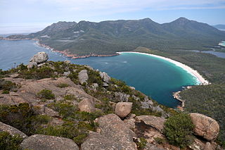
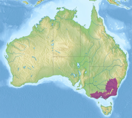
The Tasmanian temperate forests is a temperate broadleaf and mixed forests ecoregion in Australia. The ecoregion occupies the eastern portion of the island of Tasmania, which lies south of the Australian mainland.

Tasmanian Central Highland forests Terrestrial ecoregion in Tasmania, Australia

The Tasmanian Central Highland forests is a temperate broadleaf and mixed forests ecoregion in Australia. It covers Tasmania's Central Highlands region.

<span class="mw-page-title-main">Gippsland Plains Grassy Woodland</span> Ecological community in southern Victoria

The Gippsland Plains Grassy Woodland is an ecological temperate grassland community located in the Gippsland region in southern Victoria, Australia. Stretching from Bairnsdale in the east to the eastern portion of Melbourne in the west, they typify one of Victoria's most threatened and disconnected indigenous ecosystems. The Gippsland Red Gum Grassy Woodland is the most prominent community in the system situated in the centre.

<span class="mw-page-title-main">Blue Mountains and Southern Highlands Basalt Forests</span> Ecological community in New South Wales

The Blue Mountains and Southern Highlands Basalt Forests are a sclerophyll temperate forest community that stretch from the northern fringes of the Blue Mountains to the Southern Highlands. Featuring both wet and dry sclerophyll forests, as well as small rainforest pockets, the community features tall (30m+) and open eucalypt forests and woodlands that lie on igneous rock.

References

  1. 1 2 3 4 5 6 7 8 9 "Southeast Australia temperate forests". Terrestrial Ecoregions. World Wildlife Fund.
  2. 1 2 "Southeast Australia temperate forests. DOPA Explorer. Accessed 3 February 2021.
  3. "Map of Ecoregions 2017". Resolve. Retrieved August 20, 2021.
  4. "Southeast Australia temperate forests". The Encyclopedia of Earth. Retrieved August 20, 2021.