Montague Island (Australia)

Last updated

Montague island
(Barunguba)
Native name:
Barunguba
MontagueIslandFmNarooma.jpg
The island viewed from Narooma, 9 kilometres (5.6 mi) away
Geography
Location Tasman Sea
Administration
Australia
State New South Wales
Montague Island Nature Reserve
New South Wales
IUCN category IV (habitat/species management area)
MontagueIslandSeals.JPG
Australian fur seals located in the water adjacent to the island
Australia New South Wales relief location map.png
Red pog.svg
Montague Island Nature Reserve
Nearest town or city Narooma
Coordinates 36°15′S150°13′E / 36.250°S 150.217°E / -36.250; 150.217 Coordinates: 36°15′S150°13′E / 36.250°S 150.217°E / -36.250; 150.217
EstablishedJanuary 1990 (1990-01) [1]
Area0.81 km2 (0.3 sq mi) [1]
Visitation6,000 (in 2002)
Managing authorities NSW National Parks & Wildlife Service
Website Montague Island Nature Reserve
See also Protected areas of
New South Wales

Montague Island (Yuin: Barunguba) is a continental island contained within the Montague Island Nature Reserve, a protected nature reserve that is located offshore from the South Coast region of New South Wales, in eastern Australia. The nearest town located onshore from the 81-hectare (200-acre) reserve and island is Narooma, situated approximately 9 kilometres (5.6 mi) to the northwest. [2]

Contents

Montague Island is the second largest island off the New South Wales east coast after Lord Howe Island. It has been classified by the National Trust as a Landscape Conservation Area for its scenic, scientific and historical values. The Montague Island Light buildings are entered on the Register of the National Estate because of the architectural quality of the tower and residences. [2]

The island was first sighted by Europeans in 1770 by James Cook and named Cape Dromedary, then identified as an island and named by the master of the Second Fleet convict transport Surprize after George Montagu-Dunk, 2nd Earl of Halifax. [3] [4]

Montague Island is a popular tourist destination, known for its lighthouse, wildlife, most especially little penguins (Eudyptula minor), and recreational activities; managed by the NSW National Parks & Wildlife Service (NPWS). [5] Public access to the island is restricted to guided tours conducted by the NPWS in association with private operators. [2]

Lighthouse

A lighthouse is maintained on the island by the Australian Maritime Safety Authority. The lighthouse was designed by James Barnet and built in 1881. It was automated in 1986 and demanned in 1987. The lighthouse is 21 metres (69 ft) tall and the light is 80 metres (260 ft) above sea level with a nominal range of 20 nautical miles (37 km; 23 mi) and a geographic range of 17 nautical miles (31 km; 20 mi). The original Fresnel lens was removed in 1986 and is now on display at the Narooma Lighthouse Museum. [6]

The next lighthouse to the north is the Burrewarra Point lighthouse. Amateur radio expeditions to the island were organised in 2010 and 2011.

Wildlife

Forty nine species of fauna have been recorded on the island by the New South Wales National Parks and Wildlife Service. [7]

Little penguins

The island is home to a large colony of little penguins on the island. As the island has no foxes or feral cats, the penguins have no predators other than other seabirds and seals. With the restoration of native habitat and the provision of penguin breeding boxes, penguin numbers have increased, and there are now approximately 12,000 on the island. The female usually lays two eggs, and during a good year, both chicks will survive. The birds come ashore at dusk after feeding at sea, and visitors to the island can watch the birds from a platform near the jetty.

Crested terns

Crested terns, Sterna bergii, have brilliant white feathers covering the body while the head is completely black.

Shearwaters

Shearwaters, also known as mutton birds, nest on the island. Species recorded are:

Seals

The northern tip of the island is the seasonal home to a seal bachelor colony. Due to the site's remoteness, it is only possible for visitors to see them from a boat.

The majority of the seals are Australian fur seals, (Arctocephalus pusillus doriferus), New Zealand fur seals (Arctocephalus forsteri), subantarctic fur seals (Arctocephalus tropicalis) and Australian sea lions (Neophoca cinerea) have also been observed.

Climate

Climate data for Montague Island
MonthJanFebMarAprMayJunJulAugSepOctNovDecYear
Record high °C (°F)41.0
(105.8)
37.2
(99.0)
33.8
(92.8)
29.1
(84.4)
26.9
(80.4)
22.0
(71.6)
24.0
(75.2)
25.9
(78.6)
31.7
(89.1)
34.1
(93.4)
34.9
(94.8)
37.2
(99.0)
41.0
(105.8)
Average high °C (°F)23.0
(73.4)
23.3
(73.9)
22.4
(72.3)
20.5
(68.9)
18.2
(64.8)
16.2
(61.2)
15.5
(59.9)
16.1
(61.0)
17.5
(63.5)
18.8
(65.8)
20.0
(68.0)
21.7
(71.1)
19.4
(66.9)
Average low °C (°F)17.4
(63.3)
17.9
(64.2)
17.1
(62.8)
15.2
(59.4)
13.2
(55.8)
11.1
(52.0)
10.0
(50.0)
10.2
(50.4)
11.3
(52.3)
12.7
(54.9)
14.2
(57.6)
16.0
(60.8)
13.9
(57.0)
Record low °C (°F)9.5
(49.1)
5.9
(42.6)
9.6
(49.3)
6.9
(44.4)
5.7
(42.3)
3.1
(37.6)
2.1
(35.8)
2.2
(36.0)
4.5
(40.1)
6.9
(44.4)
6.7
(44.1)
8.7
(47.7)
2.1
(35.8)
Average precipitation mm (inches)71.1
(2.80)
83.5
(3.29)
100.3
(3.95)
81.4
(3.20)
74.3
(2.93)
96.7
(3.81)
51.6
(2.03)
53.7
(2.11)
57.4
(2.26)
63.0
(2.48)
76.1
(3.00)
65.4
(2.57)
881.8
(34.72)
Average precipitation days10.510.310.98.88.58.86.98.08.810.212.111.0114.8
Source: Bureau of Meteorology [8]


Environmental restoration

Kikuyu grass is a major weed on the island. Originally introduced in the early 19th century to help feed the animals kept by the lighthouse keepers and their families, it has spread to cover most of the south island. To control it, NPWS officers poison a section, then burn it, before replanting with help from volunteers. In the less accessible areas of the northern and eastern parts, an aerial spraying program is used to manage the kikuyu where it infests shearwater breeding sites. The kikuyu is a barrier for the shearwaters and penguins who cannot penetrate it to move or to burrow. Various native species are used to replant areas after the kikuyu grass has been controlled.

See also

Related Research Articles

Lion Island (New South Wales) Protected area in New South Wales, Australia

Lion Island is a river island that is located at the mouth to the Hawkesbury River inside Broken Bay, in the state of New South Wales, Australia. The island is considered part of the Central Coast Council. It is a descriptive name because it resembles a Sphinx, a mythical figure of a crouching lion.

Guafo Island

Guafo Island is an island located southwest of Chiloé Island and northwest of Chonos Archipelago, Chile. This location and the prevailing westerly winds bring frequent rainstorms to the island. Ocean currents bring an abundance of fish into this area, making it one of the most productive marine areas in the Southern Pacific Ocean. Because of this, numerous marine vertebrates such as fur seals, sea lions and penguins come to the island to feed and reproduce.

Five Islands Nature Reserve Protected area in New South Wales, Australia

The Five Islands Nature Reserve is a protected nature reserve located in the Tasman Sea, off the Illawarra east coast of the state of New South Wales, Australia. The 26-hectare (64-acre) reserve comprises five continental islands that are situated between 0.5 and 3.5 kilometres east of Port Kembla. The Five Islands are Flinders Islet, Bass Islet, Martin Islet, Big Island and Rocky Islet.

Wilsons Peak Flora Reserve Protected area in New South Wales, Australia

The Wilsons Peak Flora Reserve is a protected nature reserve that is located in the Northern Rivers region in the state of New South Wales, in eastern Australia. The reserve is bounded to the north by the border between New South Wales and the state of Queensland. The nearest town is the Queensland settlement of Killarney.

Davis Scrub Nature Reserve Protected area in New South Wales, Australia

The Davis Scrub Nature Reserve is a protected nature reserve that is located in the Northern Rivers region of New South Wales, Australia. The 13-hectare (32-acre) reserve is a sub tropical rainforest remnant of the Big Scrub and is situated at 170 metres (560 ft) above sea level on an undulating high rainfall plain near Alstonville.

Susan Island Nature Reserve Protected area in New South Wales, Australia

The Susan Island Nature Reserve is a protected nature reserve containing Susan Island, a river island, that is located in the Clarence River, in the Northern Rivers region of New South Wales in eastern Australia. The 23-hectare (57-acre) reserve is situated near Grafton. The island and reserve is a rare 16.5-hectare (41-acre) example of sub tropical lowland rainforest.

Andrew Johnston Big Scrub Nature Reserve Protected area in New South Wales, Australia

The Andrew Johnston Big Scrub Nature Reserve is a protected nature reserve in the Northern Rivers region of New South Wales, Australia. A subtropical jungle remnant of the Big Scrub, the 21-hectare (52-acre) reserve is approximately 19 kilometres (12 mi) northeast of Lismore. Far less than 1% of the original Big Scrub now remains.

Iluka Nature Reserve Protected area in New South Wales, Australia

The Iluka Nature Reserve in a protected nature reserve that is located in the Northern Rivers region of New South Wales, Australia. The 135-hectare (330-acre) reserve is situated near the coastal town of Iluka.

Montague Island Light Lighthouse in New South Wales, Australia

The Montague Island Light is a heritage-listed active lighthouse located on Montague Island, an island in the Tasman Sea, 9 kilometres (5.6 mi) offshore from Narooma on the south coast of New South Wales, Australia. The lighthouse is located at the highest point of the island. It was designed by James Barnet and NSW Colonial Architect and built from 1878 to 1881 by J. Musson and completed By W. H. Jennings. It is also known as the Montague Island Lightstation and its setting. The property is owned by the Office of Environment and Heritage, an agency of the Government of New South Wales. It was added to the New South Wales State Heritage Register on 2 April 1999, and the Commonwealth Heritage List on 22 June 2004.

Yathong Nature Reserve Protected area in New South Wales, Australia

The Yathong Nature Reserve is a protected nature reserve that is also a nationally and internationally recognized biosphere situated in the central-western region of New South Wales, in eastern Australia. The 107,240-hectare (265,000-acre) reserve was listed by UNESCO in 1977 as a Biosphere Reserve under the Man and the Biosphere Programme (MAB). The reserve is significant for its biodiversity in both native plant and animal species. Cultural heritage and historical grazing activities add to the significance of this site as a conservation area.

Brush Island Protected area in New South Wales, Australia

The Brush Island is a continental island, contained within the Brush Island Nature Reserve, a protected nature reserve, known as Mit Island in the Dhurga language of the Murramamrang people of the Yuin nation see It is located off the south coast of New South Wales, Australia. The 47-hectare (120-acre) island and reserve is situated within the Tasman Sea, approximately 2 kilometres (1.2 mi) south-east of the coastal village of Bawley Point.
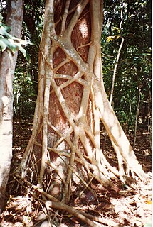
Isles of St Francis Conservation Park Protected area in South Australia

.

Hayters Hill Nature Reserve Protected area in New South Wales, Australia

The Hayters Hill Nature Reserve is a protected nature reserve that is located in the Northern Rivers region in the state of New South Wales, in eastern Australia. The 8-hectare (20-acre) forest remnant is located on high ground some 5 kilometres (3.1 mi) southwest of Byron Bay.

Bird Island Nature Reserve Protected area in New South Wales, Australia

The Bird Island Nature Reserve is a protected nature reserve located near Lake Munmorah on the Central Coast region of New South Wales, Australia. The island is situated 1.4 kilometres (0.87 mi) off the east coast of New South Wales, within the Tasman Sea. The reserve may be seen from the lighthouse at Norah Head.

Batemans Bay (bay)

Batemans Bay is an open oceanic embayment that is located in the South Coast region of New South Wales, Australia. The bay forms the mouth of the Clyde River and its primary outflow is to the Tasman Sea of the South Pacific Ocean.

Whidbey Isles Conservation Park Protected area in South Australia

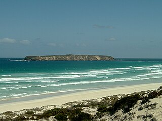
The Whidbey Isles Conservation Park is a protected area in the Australian state of South Australia which consists of seven islands located about 15 kilometres (9.3 mi) west-southwest of Coffin Bay on the lower Eyre Peninsula.

Solitary Islands Marine Park Marine protected area in New South Wales, Australia

Solitary Islands Marine Park (SIMP) is a marine park in New South Wales State waters, Australia. It adjoins the Solitary Islands Marine Reserve and was declared under the Marine Parks Act 1997 (NSW) in January 1998. Prior to this it was declared a marine reserve in 1991. The Park was one of the first declared in NSW and stretches along the northern NSW coast, from Muttonbird Island, Coffs Harbour, to Plover Island near Sandon River, 75 kilometres to the north. It includes coastal estuaries and lakes and extends from the mean high water mark, to three nautical miles out to sea, covering an area of around 72 000 hectares. There are five main islands in the Park, North Solitary Island, North West Solitary Island, South West Solitary Island, South Solitary Island and Split Solitary Island, as well as other significant outcrops such as Muttonbird Island and submerged reefs.

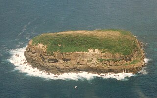
Muttonbird Island Nature Reserve is a nature reserve off the shore of Coffs Harbour, New South Wales, Australia, on the southern boundary of the Solitary Islands Marine Park. It is linked to the mainland by a causeway, which acts as the northern breakwater for the harbour. With over 5,500 breeding pairs, it is a major breeding ground for wedge-tailed shearwaters, known locally as muttonbirds, which migrate annually to the Philippines but return to breed on the island.

Investigator Group Conservation Park Protected area in South Australia

.

Cook Island Nature Reserve Protected area in Australia

Cook Island Nature Reserve is a protected area in the Australian state of new South Wales located on Cook Island about 600 metres (2,000 ft) off the coastline from the headland of Fingal Head and about 4 kilometres (2.5 mi) south-east of Tweed Heads on the state's north coast.

References

  1. 1 2 "Montague Island Nature Reserve: Park management". Office of Environment & Heritage. Government of New South Wales . Retrieved 30 September 2014.
  2. 1 2 3 Montague Island Nature Reserve: Plan of management (PDF). NSW National Parks & Wildlife Service (PDF). Government of New South Wales. November 1995. ISBN   978-0-7310-0852-0 . Retrieved 30 September 2014.
  3. Flinders, Matthew (1814). A Voyage to Terra Australis. London: G. and W. Nicol., entry for 3 February 1798
  4. Reed, A. W. (1969). Place names of New South Wales, their origins and meanings. Sydney: Reed Books.
  5. "Adventure - Montague Island Nature Reserve". VisitNSW. Government of New South Wales . Retrieved 7 April 2013.
  6. Rowlett, Russ. "Lighthouses of Australia: New South Wales". The Lighthouse Directory. University of North Carolina at Chapel Hill.
  7. (Wildlife atlas) Archived 15 June 2005 at the Wayback Machine
  8. "Climate Statistics for Montague Island Lighthouse". Climate statistics for Australian locations. Bureau of Meteorology. Retrieved 13 November 2016.