
The Mallanganee National Park is a protected national park located in the Northern Rivers region of New South Wales, Australia. The 1,144-hectare (2,830-acre) park is located approximately 570 kilometres (350 mi) north of Sydney and can be located via Kyogle via the Bruxner Highway and the Summerland Way.

The Limpinwood Nature Reserve is a protected nature reserve that is located on the Northern Rivers region of New South Wales, in eastern Australia. The reserve was gazetted in April 1963 with additions made in 1967, over former fauna and crown reserves, and further additions were made in 1988 to make the reserve to its current area of 2,646 hectares. The reserve is situated north-west of the rural locality of Limpinwood, and north of Tyalgum and defines part of the state border between New South Wales and Queensland.
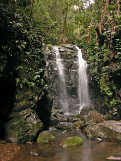
The Gondwana Rainforests of Australia, formerly known as the Central Eastern Rainforest Reserves, are the most extensive area of subtropical rainforest in the world. Collectively, the rainforests are a World Heritage Site with fifty separate reserves totalling 366,500 hectares from Newcastle to Brisbane.
The Boorganna Nature Reserve is a protected nature reserve located northwest of Taree on the Comboyne Plateau in New South Wales, Australia. The 396-hectare (980-acre) reserve, managed by the NSW National Parks & Wildlife Service, was gazetted in 1904 and is the second oldest nature reserve in the state. The reserve features various forest types, including stands of sub tropical rainforest of which the large rosewood, yellow carabeen and small leaf fig are particularly noteworthy. The reserve is a remnant of the former extensive rainforest on the Comboyne Plateau. The plateau was cleared between 1900 and 1925. Australian red cedar was logged in the area in the nineteenth century. Originally proposed to be part of the world heritage rainforest group. The exploration, knowledge, uses and history of this area by Indigenous Australians is not well known in the present day.

Numinbah Nature Reserve is a protected nature reserve that is located in the Northern Rivers region of New South Wales, in eastern Australia. The reserve was gazetted in December 1981 with a further addition made in 1989 to make the reserve to its current area of 858 hectares. The reserve is situated north-east of the rural locality of Numinbah, and south of the Queensland town of Springbrook and defines part of the state border between New South Wales and Queensland.

The Mount Hyland Nature Reserve is a protected nature reserve that is located in the New England region of New South Wales, in eastern Australia. The 2,519-hectare (6,220-acre) reserve is situated approximately 35 kilometres (22 mi) west of Dorrigo.

The Fenwicks Scrub Flora Reserve is a protected nature reserve that is located on the Mid North Coast of New South Wales, Australia. The 110-hectare (270-acre) reserve is situated west of Port Macquarie on the Great Dividing Range. The reserve is dominated by warm temperate rainforest. Rainforest occurs between 990 and 1,100 metres above sea level. The 20 metres (66 ft) tall canopy is 98% Sassafras and Coachwood.

The Yatteyattah Nature Reserve is a protected nature reserve in the south coast region of New South Wales, in eastern Australia. The 35-hectare (86-acre) reserve is situated near Milton.

The Wilsons Peak Flora Reserve is a protected nature reserve that is located in the Northern Rivers region in the state of New South Wales, in eastern Australia. The reserve is bounded to the north by the border between New South Wales and the state of Queensland. The nearest town is the Queensland settlement of Killarney.

The Victoria Park Nature Reserve is a protected nature reserve that is located in the Northern Rivers region in the state of New South Wales, in eastern Australia. The sub-tropical jungle remnant is located an undulating high rainfall plain near Alstonville. The red-brown soil is derived from a basaltic flow from the nearby Mount Warning. Of the total land in the reserve, 8 hectares is original rainforest; and the other areas are being re-vegetated.

The Susan Island Nature Reserve is a protected nature reserve containing Susan Island, a river island, that is located in the mouth of the Clarence River, in the Northern Rivers region of New South Wales in eastern Australia. The 23-hectare (57-acre) reserve is situated near Grafton. The island and reserve is a rare 16.5-hectare (41-acre) example of sub tropical lowland rainforest.

The Coocumbac Island Nature Reserve is a protected nature reserve located in the mid–north coast region of New South Wales, Australia. The 6-hectare (15-acre) reserve, situated on the Manning River near Taree, is a rare example of a subtropical lowland rainforest.
The Iluka Nature Reserve in a protected nature reserve that is located in the Northern Rivers region of New South Wales, Australia. The 135-hectare (330-acre) reserve is situated near the coastal town of Iluka.

The Hayters Hill Nature Reserve is a protected nature reserve that is located in the Northern Rivers region in the state of New South Wales, in eastern Australia. The 8-hectare (20-acre) forest remnant is located on high ground some 5 kilometres (3.1 mi) southwest of Byron Bay.
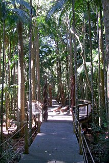
The Sea Acres National Park is a national park that is located in the Mid North Coast region of New South Wales, in eastern Australia. The 76-hectare (190-acre) park is situated near the town of Port Macquarie. The park is a popular tourist area with a 1.3-kilometre (0.81 mi) long boardwalk through a remnant of seaside rainforest. There is also an education centre and cafe. The park was initially declared as a nature reserve in 1987; and gazetted as a national park in October 2010.

The Kattang Nature Reserve is a protected nature reserve that is located in the Mid North Coast region of New South Wales, on the eastern coast of Australia. The 68-hectare (170-acre) reserve is situated 7 kilometres (4.3 mi) from Laurieton, 47 kilometres (29 mi) south of Port Macquarie and 10 kilometres (6.2 mi) east of the Pacific Highway, near Kew.

The Gamilaroi Nature Reserve is a protected nature reserve, part of the southern Brigalow Belt, that is located in the North West Slopes region of New South Wales, in eastern Australia. The 113-hectare (280-acre) reserve is situated 48 kilometres (30 mi) southeast of Moree, and about 6 kilometres (3.7 mi) south of Terry Hie Hie, at an elevation of 340 metres (1,120 ft) above sea level. The reserve is one of seven sites in the state where ooline occurs naturally. For this reason, the reserve is not promoted for recreation; and visits are not encouraged.

The Brunswick Heads Nature Reserve is a protected nature reserve located in the Northern Rivers region of New South Wales, Australia. The 221-hectare (550-acre) reserve is situated near Brunswick Heads and contains an intact segment of littoral rainforest.

The Stotts Island Nature Reserve is a protected nature reserve containing the Stotts Island, a river island, that is located in the Tweed River, in the Northern Rivers region of New South Wales in eastern Australia. The 141-hectare (350-acre) reserve is situated near Tweed Heads and 12 kilometres (7.5 mi) northeast of Murwillumbah.
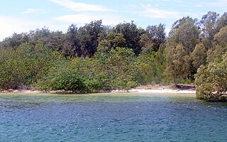
The Ukerabagh Island is a river island, contained within the Ukerabagh Island Nature Reserve, a protected nature reserve, that is located in the mouth of the Tweed River, in the Northern Rivers region of New South Wales in eastern Australia. The 125-hectare (310-acre) reserve is situated near Tweed Heads and 1 kilometre (0.62 mi) south of a section that defines the border between the states of New South Wales and Queensland. The island and reserve is an important site for coastal birds.


