A shopping mall is a North American term for a large indoor shopping center, usually anchored by department stores. The term "mall" originally meant a pedestrian promenade with shops along it, but in the late 1960s, it began to be used as a generic term for the large enclosed shopping centers that were becoming commonplace at the time. In the U.K., such complexes are considered shopping centers, though "shopping center" covers many more sizes and types of centers than the North American "mall". Other countries may follow U.S. usage and others follow U.K. usage.
A shopping center or shopping centre is a group of shops built together, sometimes under one roof.

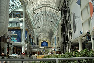
The Toronto Eaton Centre is a shopping mall and office complex in Downtown Toronto, Ontario, Canada. It is owned and managed by Cadillac Fairview (CF). It was named after the Eaton's department store chain that once anchored it before the chain became defunct in the late 1990s.
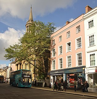
High Street is a common street name for the primary business street of a settlement, especially in the United Kingdom and Commonwealth of Nations. It implies that it is the focal point for business, especially shopping. It is also a metonym for the retail sector.

Tysons Corner Center, located in the Tysons unincorporated area in Fairfax County, Virginia, United States, opened to the public in 1968, becoming one of the first fully enclosed, climate-controlled shopping malls in the Washington metropolitan area.

A strip mall is a type of open-air shopping center common in North America where the stores are arranged in a row, with a sidewalk in front. Strip malls are typically developed as a unit and have large parking lots in front. Many of them face major traffic arterials and tend to be self-contained with few pedestrian connections to surrounding neighborhoods. Smaller strip malls may be called mini-malls, while larger ones may be called power centers or big box centers.
Stockland Glendale is a major shopping centre located in Glendale, a suburb of the City of Lake Macquarie, New South Wales, Australia.

Rundle Mall is a pedestrian street mall located in Adelaide, South Australia. It was opened as a pedestrian mall in September 1976 by closing the section of Rundle Street between King William Street and Pulteney Street, to vehicular traffic. The street continues as Rundle Street to the east and Hindley Street to the west.

Australia Fair Shopping Centre is a dual-level regional shopping centre covering 59,540 square metres (640,900 sq ft) located in Southport, Gold Coast, Queensland. The centre also incorporates a five-level office tower comprising 5,824 square metres (62,690 sq ft) of office space, housing specialist services and commercial offices.

The Golden Mile is a commercial district in the Scarborough district of Toronto, Ontario, Canada. Situated along Eglinton Avenue East, east of Victoria Park Avenue, it was one of Canada's first model industrial parks. The original Golden Mile of Industry ran along Eglinton from Pharmacy Avenue east to Birchmount Road.

Sawgrass Mills is an outlet shopping mall operated by the Simon Property Group, in Sunrise, Florida, a city in Broward County. With 2,370,610 square feet (220,237 m2) of retail selling space, it is the eleventh largest mall in the United States, the largest single story outlet mall in the U.S., the largest shopping mall in Broward County, the second largest mall in Florida and the Miami metropolitan area after the Aventura Mall, and the third largest shopping mall in the southeastern United States. It opened in 1990 as the third mall developed by the now-defunct Mills Corporation, and was located next to BB&T Center and has been expanded four times since then, most recently in 2013. There are over 329 retail outlets and name brand discounters, with anchors including Off 5th Saks Fifth Avenue, and Super Target.

Bankstown Central Shopping Centre is a shopping centre situated in Bankstown, New South Wales, Australia. Opened as Bankstown Square on 21 September 1966, it was at the time Australia's largest and was one of Sydney's first major shopping centres. The development of the shopping centre was a moment of significance in the development of Bankstown as a satellite centre of south-western Sydney. A major centre of governmental and community service provision as well as retail commerce, the shopping centre remains an important part of the civic life for this region of Sydney.

Melbourne Central is a large shopping centre, office, and public transport hub in the city of Melbourne, Victoria, Australia. The complex includes the Melbourne Central Shopping Centre, which was refurbished in 2005 by architects Ashton Raggatt McDougall; the Melbourne Central railway station ; and the 211-metre (692 ft) high office tower with its distinctive black colour and two communications masts. The centre features a gross leasable area of 55,100 square metres (593,000 sq ft). It is owned by GPT Group.

Wollongong Central is a major shopping centre in the Illawarra region, located in the CBD of Wollongong, New South Wales approximately 90 kilometres south of Sydney. It is operated and managed by Australian property investment company, General Property Trust (GPT). It is of local importance and is used by much of the Illawarra community as a social and shopping centre. It is situated in the western half of the Crown Street Mall.
Park Central Mall was the first shopping mall in Phoenix, Arizona. It is located in Encanto Village, on Central Avenue and Osborn Road.

Pacific Centre is a shopping mall located in downtown Vancouver, British Columbia, Canada, and managed by Cadillac Fairview. Based on the number of stores, most of which are underground, it is the largest mall in Downtown Vancouver with over 100 stores and shops and the 7th busiest mall in Canada with 22.1 million annual visitors as of 2018. The mall is directly connected to the Hudson's Bay department store, Vancouver Centre Mall, two SkyTrain subway stations, and the Four Seasons Hotel Vancouver.

CrossIron Mills is a fully enclosed shopping centre development just outside the northern city limits of Calgary, Alberta, Canada, and immediately east of the hamlet of Balzac in Rocky View County. It was developed by Ivanhoé Cambridge, a major Canadian real estate company. Completed in August 2009, the mall is the largest single-level shopping centre in Alberta, containing approximately 109,440 m2 (1,178,000 sq ft) of retail and entertainment space. Immediately east of the CrossIron Mills property is Century Downs Racetrack and Casino, one of two A-level equine racetracks in Alberta. Operated by the United Horsemen of Alberta (UHA), Century Downs Racetrack and Casino has been open since April 2015.
Crossroads Mall was an enclosed shopping mall located in Omaha, Nebraska, United States, at the intersection of 72nd and Dodge Streets. Originally opened in 1960 by Omaha's Brandeis department store, the mall has been home to several major chains, including Sears, Target and Dillard's before the store closed in 2008. Most of the mall is expected to be demolished in the near future and replaced with a new mixed-use development.

The Dangar Grid is the layout of the streets in the centre of the central business district of Newcastle, Australia. Named after its designer, Henry Dangar, the Grid was designed in 1823 and implemented sometime thereafter. It covers the area from Brown Street to Pacific Street, and from Church Street to Hunter Street.


