Scabby Range Nature Reserve

Last updated

Scabby Range Nature Reserve
New South Wales
Australia New South Wales location map blank.svg
Red pog.svg
Scabby Range Nature Reserve
Nearest town or city Yaouk [2]
Coordinates 35°46′21″S148°52′48″E / 35.7725°S 148.8800°E / -35.7725; 148.8800 Coordinates: 35°46′21″S148°52′48″E / 35.7725°S 148.8800°E / -35.7725; 148.8800
Established3 December 1982 [1]
Area48.72 km2 (18.8 sq mi) [1]
Managing authorities National Parks and Wildlife Service (New South Wales)
See also Protected areas of
New South Wales
Scabby Range Nature Reserve
LocationSams River Fire Trail, Yaouk, New South Wales, Australia
Official nameScabby Range Nature Reserve
TypeListed (Natural)
Designated7 November 2008
Part ofAustralian Alps National Parks and Reserves
Reference no.105891
Official nameScabby Range Nature Reserve
TypeRegistered (Natural)
Designated30 June 1992
Reference no.13624

Scabby Range Nature Reserve is a heritage-listed protected area at Sams River Fire Trail, Yaouk, New South Wales, Australia. It was established on 3 December 1982 and added to the former Australian Register of the National Estate on 30 June 1992. [1] [2] It was added to the Australian National Heritage List as part of the Australian Alps National Parks and Reserves on 7 November 2008. [3]

Contents

Description

Scabby Range Nature Reserve has an area of about 48.72 square kilometres (18.81 sq mi) [1] and is located about 8 kilometres (5.0 mi) north-east of Yaouk. [2]

The Scabby Range Nature Reserve lies adjacent to the south-western portion of the border of the Australian Capital Territory with New South Wales border abutting Namadgi National Park and the Bimberi Wilderness area. It complements these major reserves and shares much of their wilderness character. It embraces a range of subalpine communities which have developed on a rugged and elevated section of the Murrumbidgee granite batholith and adjacent Yaouk leucogranites and Ordovician metasediments. This elevated block is heavily dissected and forms the eastern continuation of the Kosciusko Uplands with contrasting lithology and physiography. It rises to c 1800m above the Yaouk/Cabramatta plain which is a cleared pastoral area lying 600m below. Average annual precipitation is of the order of 1,400mm, some of which falls as snow and with less reliable rainfall in summer when compared to winter precipitation receipt. Above 100mm snow banks may persist for more than 3–4 months amidst the giant tors, domes and rockshelves which dominate the landscape. [2]

The vegetation is clearly subalpine in character at the higher elevations, on the more exposed sites and along the cool air drainage lines, and on the lower slopes well developed montane open forest is extensive. The dominant association is one of alpine ash Eucalyptus delegatensis and mountain gum ( Eucalyptus dalrympleana ) with various inclusions of the peppermints ( Eucalyptus radiata , Eucalyptus dives ), manna gum ( Eucalyptus viminalis ) and snowgum ( Eucalyptus pauciflora ) which frequently reach 30m in height. Alpine ash is the most prevalent species on slopes with a south-easterly aspect. Here it forms unusual uneven aged stands. Elsewhere on the more exposed, elevated sites, a range of low stature communities exists. Low woodland and tall shrubland of snowgum merges with open heathland of common shaggy pea Oxylobium ellipticum and alpine plum pine Podocarpus lawrencii and swamp heath of Epacris paludosa within polsters of Sphagnum christatum . In the lower depressions, often fringed by stands of black sallee Eucalyptus stellulata are snowgrass herbfields (dominated by Poa spp.) and sedgelands or Carex fens typified by the occurrence of Carex gaudichaudiana . Notable plant species occurrences include that of two rare or vulnerable shrubs, Australian anchor plant Discaria pubescens and an undescribed daisy bush ( Olearia sp.2, Sentry Box Hill). Other notable plant species occurrences include that of the uncommon species Bossaiea procumbens , the existence of Acacia alpina on the higher western slopes of Sentry Box Hill (as representing the only wattle species to occur beyond the montane habitat), the association of the restricted Epacris robusta with the alpine shrub Westringia lucida and the fact that here Eucalyptus delegatensis forms unusually uneven aged stands (it normally occurs as a uniformly aged post fire response elsewhere). There is also a record of the restricted and rare Grevillia diminuta , the rare Viola improcera and a distinctive form of the alpine herb Montia australasica also exist in the area. These species are found associated with the rocky microsites of the reserve which support a large number of uncommon or restricted plant taxa. Faunal records for the reserve have not been published. Abundant populations of the common wombat ( Vombatus ursinus hirsutus ) are present. Other mammals noted as occurring within the reserve include species of antechinus ( Antechinus stuartii , Antechinus swainsonii ), at least two murid rodents (the southern bush rat, Rattus fuscipes and the uncommon broad toothed rat, Mastacomys fuscus ), one possum species (the common ringtail, Pseudocheirus peregrinus peregrinus ) and two macropods (the eastern grey kangaroo, Macropus giganteus , and red-necked wallaby, Macropus rufogriseus ). More than 200 bird species are listed for Namadgi and would apply to scabby range also since the National Park surrounds this Nature Reserve. This avifauna is typical of tall sclerophyll forests and subalpine woodlands of the southern Monaro and adjacent highlands with rich representation of raptors, old world flycatchers, seasonal influxes of honeyeaters and parrots including the vulnerable glossy black cockatoo Calyptorhynchus lathami and poorly known yellow tailed black cockatoo ( Calyptorhynchus funereus ). Of note also is the fact that a significant portion of the area's birds move seasonally, overwintering at lower elevations and moving to the higher country such as the Scabby Range in summer. The reserve's herpetofauna is likely to comprise a small number of species consistent with the regional assemblage from cold, high altitude sites. Cool temperature tolerant elapids, a range of saxicoline and fossorial skinks and several species of cryptic, ground frequenting frogs (e.g., Ranidella spp., Limnodynastes tasmaniensis , etc.) make up the herpetofaunal assemblage of the Scabby Range. Mount Kelly at the reserve's northern apex, is an established focus for bushwalkers, affording outstanding panoramas of a scenic landscape with a distinctive wilderness quality. [2]

Condition

Near natural condition although the ecosystems suffer from the presence of exotic animals, particularly rabbits Oryctolagus cuniculus and pigs Sus scrofa , and with feral horses Equus caballus occasionally damaging high altitude fens and seepages. The reserve, along with the more extensive Namadgi National Park and the Bimberi Range, constitutes an area with considerable wilderness value. (1989) [2]

Heritage listing

The area has significant wilderness value as it comprises part of the core and buffer of an identified Bimberi Wilderness area. It embraces a panoramic collection of scenic peaks and spurlines. The reserve protects a good sample of well developed, minimally disturbed montane forests of mountain gum Eucalyptus dalrympleana and mountain ash ( Eucalyptus delegatensis ), with the latter species occurring in unusual uneven-aged stands on the south-easterly aspect slopes. Within the reserve, at higher elevations, is a significant group of low stature, subalpine communities including snowgum ( Eucalyptus pauciflora ) woodland and shrubland, open heathland, swamp heath and sedgeland particularly significant plant assemblages are found associated with the rock shelves, boulder jumbles and granite pavements. These accommodate a significant number of uncommon or restricted species. The nature reserve is the type locality for an undescribed species of daisy bush ( Olearia sp. 2, Sentry Box Hill) and contains populations of the rare Australian anchor plant Discaria pubescens . Other notable plant occurrences include Acacia alpina, Bossaiea procumbens, Epacris robusta, Grevillea diminuta, a distinctive form of Montia australasica and Viola improcera . The reserve represents an area of outstanding scenic amenity with high biological value. [2]

Scabby Range Nature Reserve was listed on the Australian Register of the National Estate on 30 June 1992. [2] However, the Register of the National Estate ceased to be a statutory heritage register on 2012, but is retained for archival and education purposes. It was listed on the Australian National Heritage List as part of the Australian Alps National Parks and Reserves on 7 November 2008. [3]

Related Research Articles

Namadgi National Park Protected area in Australian Capital Territory

Namadgi National Park is a protected area in the south-west of the Australian Capital Territory, bordering Kosciuszko National Park in New South Wales. It lies approximately 40 kilometres (25 mi) southwest of Canberra, and makes up approximately 46% of the ACT's land area.

Mount Buffalo National Park Protected area in Victoria, Australia

The Mount Buffalo National Park is a national park located in the alpine region of Victoria, Australia. The 31,000-hectare (77,000-acre) national park is located approximately 350 kilometres (220 mi) northeast of Melbourne in the Australian Alps. Within the national park is Mount Buffalo, a moderately high mountain plateau, with an elevation of 1,723 metres (5,653 ft) above sea level.

Kosciuszko National Park Protected area in New South Wales, Australia

The Kosciuszko National Park is a 6,900-square-kilometre (2,700 sq mi) national park and contains mainland Australia's highest peak, Mount Kosciuszko, for which it is named, and Cabramurra the highest town in Australia. Its borders contain a mix of rugged mountains and wilderness, characterised by an alpine climate, which makes it popular with recreational skiers and bushwalkers.

Australian Alps montane grasslands

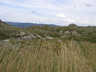
The Australian Alps montane grasslands is a montane grassland ecoregion of south-eastern Australia, restricted to the montane regions above 1300 metres.

<i>Eucalyptus delegatensis</i>

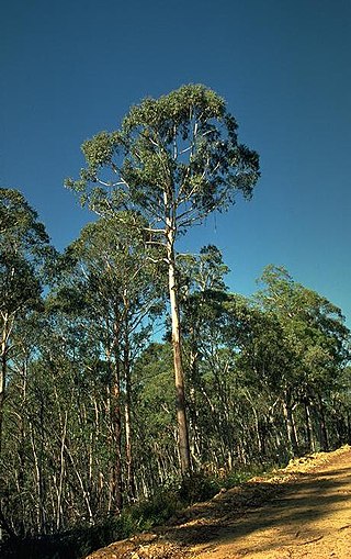
Eucalyptus delegatensis, commonly known as alpine ash, gum-topped stringybark, white-top and in Victoria as woollybutt, is a species of tree that is endemic to southeastern Australia. It has a straight trunk with rough, fibrous to stringy bark on the lower half of the trunk, smooth white bark above, lance-shaped to curved adult leaves, flower buds in groups of between seven and fifteen, white flowers and barrel-shaped or hemispherical fruit.

Brindabella Range

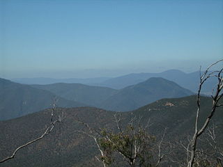
The Brindabella Range, commonly called The Brindabellas, is a mountain range located in Australia, on a state and territory border of New South Wales and the Australian Capital Territory (ACT). The range rises to the west of Canberra, the capital city of Australia, and includes the Namadgi National Park in the ACT and the Bimberi Nature Reserve and Brindabella National Park in New South Wales. The Brindabellas are visible to the west of Canberra and form an important part of the city's landscape.

Australian Alps Walking Track Hiking trail in South East Australia

The Australian Alps Walking Track is a long-distance walking trail through the alpine areas of Victoria, New South Wales and ACT. It is 655 km long, starting at Walhalla, Victoria and running through to Tharwa, ACT near Canberra. The track weaves mainly through Australian national parks, such as Alpine National Park and Kosciuszko National Park, though it is not exclusively restricted to national parks. It ascends many peaks including Mount Kosciuszko, Mount Bogong, and Bimberi Peak, the highest points in N.S.W., Victoria, and the A.C.T. respectively. The AAWT crosses exposed high plains including the Victorian Bogong High Plains and the Main Range in NSW. To walk the whole trail can take between 5 and 8 weeks. Food drops or a support crew are necessary, as the trail passes through no towns, although it passes close to the ski resorts of Mt Hotham, Falls Creek, Mt Baw Baw, Thredbo, Charlotte Pass and Perisher.

Bimberi Nature Reserve Protected area in New South Wales, Australia

The Bimberi Nature Reserve is a protected nature reserve located in the Brindabella Range of New South Wales, in eastern Australia. The 10,868-hectare (26,860-acre) reserve is situated approximately 30 km (19 mi) south west of Canberra, which is in the Australian Capital Territory.

Quamby Bluff

Quamby Bluff is a mountain in Northern Tasmania, Australia that is an outlying part of the Great Western Tiers mountain range.

<i>Eucalyptus coccifera</i>

Eucalyptus coccifera, commonly known as the Tasmanian snow gum, is a small to medium-sized tree endemic to Tasmania. It has smooth, grey and cream-coloured bark, elliptic to lance-shaped adult leaves, flower buds in groups of between three and nine, usually white flowers and conical, hemispherical or cup-shaped fruit.

Mount Kelly

Mount Kelly is a mountain with an elevation of 1,829 metres (6,001 ft) AHD  that is the tallest peak in the Scabby Range and is situated on the border of the Australian Capital Territory and New South Wales, Australia. The summit of the mountain is located within the ACT. The nearest town to the mountain is Adaminaby, approximately 32.8 kilometres (20.4 mi) to the south.

Boorganna Nature Reserve Protected area in New South Wales, Australia

The Boorganna Nature Reserve is a protected nature reserve located northwest of Taree on the Comboyne Plateau in New South Wales, Australia. The 396-hectare (980-acre) reserve, managed by the NSW National Parks & Wildlife Service, was gazetted in 1904 and is the second oldest nature reserve in the state. The reserve features various forest types, including stands of sub tropical rainforest of which the large rosewood, yellow carabeen and small leaf fig are particularly noteworthy. The reserve is a remnant of the former extensive rainforest on the Comboyne Plateau. The plateau was cleared between 1900 and 1925. Australian red cedar was logged in the area in the nineteenth century. Originally proposed to be part of the world heritage rainforest group. The exploration, knowledge, uses and history of this area by Indigenous Australians is not well known in the present day.

Mount Franklin (Australian Capital Territory)

Mount Franklin is a mountain with an elevation of 1,646 metres (5,400 ft) AHD  in the Brindabella Ranges that is located on the border between the Australian Capital Territory and New South Wales, Australia. The summit of the mountain is located in the Australian Capital Territory.

Nadgee Nature Reserve Protected area in New South Wales, Australia

The Nadgee Nature Reserve is a protected nature reserve that is located in the far south coast region of New South Wales, in eastern Australia. The 20,671-hectare (51,080-acre) reserve is situated to the immediate south of Ben Boyd National Park. Its southern border is bounded by the Black-Allan Line that marks the straight–line border between New South Wales and Victoria, where it abuts Croajingolong National Park.

Skiing in the Australian Capital Territory

Skiing in the Australian Capital Territory refers to snow skiing in the Australian Capital Territory (ACT). The highest mountain in the ACT is Bimberi Peak. Recreational skiing commenced with the formation of the Canberra Alpine Club in 1934. Since the 1930s, the ACT has had intermittent and limited alpine skiing facilities. Downhill ski facilities returned to the ACT at Corin Forest in 2016, after a two decade hiatus.

<i>Orites revolutus</i> Species of plant in the family Proteaceae endemic to Tasmania

Orites revolutus , also known as narrow-leaf orites, is a Tasmanian endemic plant species in the family Proteaceae. Scottish botanist Robert Brown formally described the species in Transactions of the Linnean Society of London in 1810 from a specimen collected at Lake St Clair. Abundant in alpine and subalpine heath, it is a small to medium shrub 0.5 to 1.5 m tall, with relatively small, blunt leaves with strongly revolute margins. The white flowers grow on terminal spikes during summer. Being proteaceaous, O. revolutus is likely to provide a substantial food source for nectivorous animal species within its range.

Black Andrew Nature Reserve Protected area in New South Wales, Australia

The Black Andrew Nature Reserve is a protected nature reserve located on the south west slopes of New South Wales, Australia. The 1,559-hectare (3,850-acre) reserve is situated on the southern shore of Burrinjuck Dam on the Murrumbidgee River, an important reservoir for the Murrumbidgee Irrigation Area.

Australian Alps National Parks and Reserves Protected area in Australia

The Australian Alps National Parks and Reserves is a group of eleven protected areas consisting of national parks, nature reserves and one wilderness park located in the Australian Capital Territory, New South Wales and Victoria and which was listed as a "place" on the Australian National Heritage List on 7 November 2008 under the Environment Protection and Biodiversity Conservation Act 1999. The listing which covers an area of 16,531.80 square kilometres (6,382.96 sq mi), contains the vast majority of alpine and sub-alpine environments in Australia. The listing includes the following protected areas - Alpine, Baw Baw, Brindabella, Kosciuszko, Mount Buffalo, Namadgi and Snowy River national parks; the Avon Wilderness Park, and the Bimberi, Scabby Range and Tidbinbilla nature reserves.

Yaouk Town in New South Wales, Australia

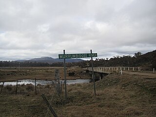
Yaouk is a locality in the Snowy Monaro Region, New South Wales, Australia. It lies in open grassland valleys surrounded by mountains on both sides of the Murrumbidgee River, downstream from and east of the Tantangara Dam, north of Adaminaby, east of the Kosciuszko National Park and south of the Namadgi National Park in the Australian Capital Territory, but separated from it by the mountainous Scabby Range. It is about 110 km south of Canberra and about 75 km northwest of Cooma. At the 2016 census, it had a population of 25.

<i>Leptospermum namadgiense</i> Australian species of plant

Leptospermum namadgiense is a species of small shrub that is endemic to areas near the border between New South Wales and the Australian Capital Territory. It has silky-hairy, narrow lance-shaped to elliptical leaves, usually white flowers borne singly or in pairs on short side shoots, and fruit that falls from the plant shortly after the seeds are released.

References

  1. 1 2 3 4 5 "Terrestrial Protected Areas of New South Wales (refer 'DETAIL' tab )". CAPAD 2016. Australian Government, Department of the Environment (DoE). 2016. Archived from the original on 9 April 2018. Retrieved 7 February 2019.
  2. 1 2 3 4 5 6 7 8 "Scabby Range Nature Reserve (Place ID 13624)". Australian Heritage Database . Department of the Environment . Retrieved 23 September 2018.
  3. 1 2 "Australian Alps National Parks and Reserves (Place ID 105891)". Australian Heritage Database . Department of the Environment . Retrieved 11 October 2018.

Bibliography

Attribution

CC-BY-icon-80x15.png This Wikipedia article was originally based on Scabby Range Nature Reserve , entry number 13624 in the Australian Heritage Database published by the Commonwealth of Australia 2018 under CC-BY 4.0 licence , accessed on 23 September 2018.