
Rhodes is an Inner West suburb of Sydney, in the state of New South Wales, Australia. Rhodes is located 12 kilometres west of the Sydney central business district, in the local government area of the City of Canada Bay. It was formerly part of Concord Municipality until a merger with Drummoyne Council to form Canada Bay in December 2000. People from Rhodes are colloquially known as Rhoders or Rhodesiens.

The Parramatta River is an intermediate tide-dominated, drowned valley estuary located in Sydney, New South Wales, Australia. With an average depth of 5.1 metres (17 ft), the Parramatta River is the main tributary of Sydney Harbour, a branch of Port Jackson. Secondary tributaries include the smaller Lane Cove and Duck rivers.
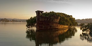
Homebush Bay is a bay on the south bank of the Parramatta River, in the west of Sydney, Australia. The name is also sometimes used to refer to an area to the west and south of the bay itself, which was formerly an official suburb of Sydney, and has now become the suburbs of Sydney Olympic Park, Wentworth Point and part of the neighbouring suburb of Lidcombe, all part of the City of Parramatta. Homebush Bay is located 13 kilometres (8.1 mi) west of the Sydney central business district.

Homebush is a suburb in the Inner West of Sydney in the state of New South Wales, Australia. It is located 12 kilometres west of the Sydney central business district, in the local government area of the Municipality of Strathfield.
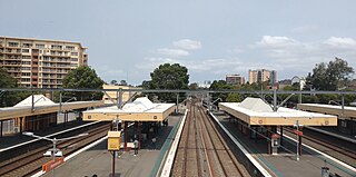
Homebush railway station is a heritage-listed railway station located on the Main Suburban line in Homebush in the Municipality of Strathfield local government area of New South Wales, Australia. It was designed and built by the New South Wales Government Railways and opened on 26 September 1855. In addition to being located on the Main Suburban line, the station is also located on the Main South and Main Western railway lines. The property was added to the New South Wales State Heritage Register on 2 April 1999.

Strathfield railway station is a heritage-listed railway station located on the Main Suburban line in the Sydney suburb of Strathfield in the Municipality of Strathfield local government area of New South Wales, Australia. The station is served by Sydney Trains T1 North Shore & Western Line, T9 Northern Line and T2 Inner West & Leppington Line suburban services as well as NSW TrainLink Intercity and regional services. The station is located on the Main Northern and Main Western railway lines, forming a major junction for regional and suburban rail services. The station and associated infrastructure was added to the New South Wales State Heritage Register on 2 April 1999.

Newington is a western suburb of Sydney, in the state of New South Wales, Australia. It is 16 kilometres west of the Sydney central business district, in the local government area of City of Parramatta.
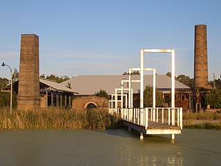
Holroyd is a small suburb in western Sydney, New South Wales, Australia. Holroyd is located 20 kilometres (12 mi) west of the Sydney central business district in the local government area of the Cumberland Council. The previous local government area of Holroyd City took its name from Arthur Holroyd, first Mayor of the area, local landowner and businessman. The administrative centre is located in nearby Merrylands.

Kirrawee is a suburb in southern Sydney, in the state of New South Wales, Australia. Kirrawee is located 25 kilometres south of the Sydney central business district in the Sutherland Shire. Kirrawee lies between Sutherland, to the west, and Gymea and Grays Point, to the east. Kirrawee's southern border is formed by The Royal National Park, while Kareela and Jannali form the northern border.
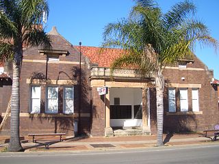
Lidcombe is a suburb in western Sydney, in the state of New South Wales, Australia. Lidcombe is located 15 km (9.32 mi) west of the Sydney central business district, in the local government area of Cumberland Council, with a small industrial part in the north in the City of Parramatta. Post code: 2141, sharing it with Berala.
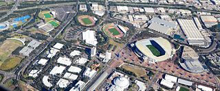
Sydney Olympic Park is a suburb of Greater Western Sydney, located 13 kilometres west of the Sydney central business district, in the local government area of the City of Parramatta Council. It is commonly known as Olympic Park but officially named Sydney Olympic Park. The area was part of the suburb of Lidcombe and known as "North Lidcombe", but between 1989 and 2009 was named "Homebush Bay". The names "Homebush Bay" and, sometimes, "Homebush" are still used colloquially as a metonym for Stadium Australia as well as the Olympic Park precinct as a whole, but Homebush is an older, separate suburb to the southeast, in the Municipality of Strathfield.

Oak Flats railway station is a single-platform intercity train station located in Oak Flats, New South Wales, Australia, on the South Coast railway line. The station serves NSW TrainLink trains travelling south to Kiama and north to Wollongong and Sydney. Together with the Dunmore and later Shellharbour Junction stations, Oak Flats has long served as the rail connection for the coastal suburbs of the City of Shellharbour.

Sydney is well endowed with open spaces and has many natural areas. Many of these exist even within the compact city centre. These include the Chinese Garden of Friendship and Hyde Park. The metropolitan area contains several national parks, including the Royal National Park, the second oldest national park in the world, which occupies an area of 132 square kilometres. Completing Sydney's wide array of green spaces, the leader is the Royal Botanical Gardens, with its large amount of green spaces, lush plants and colourful flowers.

Henson Park is a multi purpose sports ground in Marrickville, New South Wales, Australia.

Newington House is a historic house in Silverwater, New South Wales, Australia and is located 20 kilometres (12 mi) west of the Sydney central business district, in the local government area of the City of Parramatta. The house and chapel are situated on the southern bank of the Parramatta River and are now enclosed by the Silverwater Correctional Centre. With Elizabeth Bay House and Camden Park, it is considered to be one of the three great houses of the County of Cumberland.

Bicentennial Park is a 40-hectare (99-acre) suburban parkland located 16 kilometres (9.9 mi) west of the Sydney central business district in the suburb of Sydney Olympic Park, in the local government area of City of Parramatta, New South Wales, Australia. Bicentennial Park is situated on the shores of Homebush Bay and is a part of the Sydney Olympic Park. The park is a natural heritage site featuring an important wetland ecosystem and parklands.

Newington Armory is a heritage-listed former Royal Australian Navy armament depot, now used for tourism purposes, at Holker Street, Sydney Olympic Park, Cumberland Council, New South Wales, Australia. It was built from 1897 initially by the New South Wales Military Forces then by the Australian Army and later by the Royal Australian Navy. It is also known as Millennium Heritage Parklands Precinct, RAN Armament Depot Newington, Royal Australian Navy Armament Depot (RANAD), Newington Nature Reserve and Sydney Olympic Games site. The property is owned by the Sydney Olympic Park Authority. It was added to the New South Wales State Heritage Register on 14 January 2011.

Wentworth Point is a suburb of Sydney, in the state of New South Wales, Australia. It is located 13 kilometres west of the Sydney central business district, on the eastern edge of the local government area of City of Parramatta. It is on the western shore of Homebush Bay on the southern side of the Parramatta River. Wentworth Point is usually regarded as part of the Greater Western Sydney region, including in administrative contexts, but it is also regarded as part of the Inner West region of Sydney in some contexts, especially commercial contexts.

The Olympic Park railway line is a railway line linking the Sydney Olympic Park precinct to the Main Suburban railway line at Flemington and Lidcombe. Originally opened as the Abattoirs branch in 1911, it was rebuilt and reopened as the Olympic Park railway line in 1998. Passenger services have since been running on it as the Olympic Park Line.

The Glebe and Wentworth Park railway viaducts are a series of two heritage-listed railway bridges and arch viaducts that carry the Inner West Light Rail across Wentworth Park, Jubilee Park, and Johnstons Creek in the inner western Sydney suburb of Glebe in the City of Sydney local government area of New South Wales, Australia. They were designed by the New South Wales Government Railways and built from 1892 to 1922 by day labour. They are also known as Wentworth Park Viaduct, Jubilee Park Viaduct and Glebe Viaducts. The viaducts were added to the New South Wales State Heritage Register on 2 April 1999.


