
Deua is a national park located in New South Wales, Australia, 320 kilometres (200 mi) south of Sydney, and 100 kilometres (62 mi) east of Canberra. The nearest towns on the coast are Batemans Bay, Moruya and Narooma.

The Great Otway National Park is a national park located in the Barwon South West region of Victoria, Australia. The 103,185-hectare (254,980-acre) national park is situated approximately 162 kilometres (101 mi) southwest of Melbourne, in the Otway Ranges, a low coastal mountain range. It contains a diverse range of landscapes and vegetation types.

The Tarra-Bulga National Park is a small national park located in the South Gippsland region of eastern Victoria, Australia approximately 240 kilometres (150 mi) south east of Melbourne. The park is located 33 kilometres (21 mi) south of Traralgon on the Traralgon-Balook Road and 24 kilometres (15 mi) north of Yarram.

Hygrocybe is a genus of agarics in the family Hygrophoraceae. Called waxcaps in English, basidiocarps are often brightly coloured and have dry to waxy caps, white spores, and smooth, ringless stems. In Europe they are characteristic of old, unimproved grasslands which are a declining habitat, making many Hygrocybe species of conservation concern. Four of these waxcap-grassland species, Hygrocybe citrinovirens, H. punicea, H. spadicea, and H. splendidissima, are assessed as globally "vulnerable" on the IUCN Red List of Threatened Species. Elsewhere waxcaps are more typically found in woodlands. Most are ground-dwelling and all are believed to be biotrophs. Around 150 species are recognized worldwide. Fruit bodies of several Hygrocybe species are considered edible and are sometimes offered for sale in local markets.

The Cumberland Plain, an IBRA biogeographic region, is a relatively flat region lying to the west of Sydney CBD in New South Wales, Australia. Cumberland Basin is the preferred physiographic and geological term for the low-lying plain of the Permian-Triassic Sydney Basin found between Sydney and the Blue Mountains, and it is a structural sub-basin of the Sydney Basin.

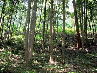
The Sydney Turpentine-Ironbark Forest (STIF) is wet sclerophyll forest community of Sydney, New South Wales, Australia, that is typically found in the Inner West and Northern region of Sydney. It is also among the three of these plant communities which have been classified as Endangered, under the New South Wales government's Threatened Species Conservation Act 1995, with only around 0.5% of its original pre-settlement range remaining.

Hygrocybe aurantipes is a gilled fungus of the waxcap family found in a few scattered locations in wet forests in eastern Australia. It is a distinctive small mushroom with a 2–4 cm diameter olive-brown cap and golden-yellow stipe and gills, not easily confused with any other species. Known only from Lane Cove Bushland Park in Sydney's suburban Lower North Shore, Hazelbrook and Mount Wilson in the Blue Mountains, it has been designated as vulnerable as defined by the NSW Biodiversity Conservation Act 2016, by the New South Wales Government.

Hygrocybe austropratensis is a gilled fungus of the waxcap family found in a few scattered locations in dry sclerophyll forests in eastern Australia. It is a small mushroom with a 1.4–3 cm diameter pale orange or orange-brown cap and buff-coloured stipe and gills. It is known only from near Sydney, Hazelbrook in the Blue Mountains, and Victoria.
The Garawarra State Conservation Area is a protected conservation area that is located on the southern suburban fringe of Greater Sydney, in the state of New South Wales, in eastern Australia. The 949-hectare (2,350-acre) reserve abuts the Royal National Park and is situated 40 kilometres (25 mi) south of the Sydney central business district, near Helensburgh. Garawarra was gazetted as a park in 1987, and added, together with the Royal National Park, to the Australian National Heritage List on 15 September 2006.

Hygrocybe lanecovensis is an Australian mushroom of the waxcap genus Hygrocybe. An endangered species, it is found only at Lane Cove Bushland Park in suburban Sydney.

The Southern Sydney sheltered forest, or the Sydney Sandstone Gully Forest (SSGF), is a vegetation community found in Sydney, Australia that comprises an open forest composition grading into woodland or scrub, typically within gullies. The community is normally associated with sheltered heads and upper inclines of gullies on transitional zones where sandstone outcropping may be present.
The Kangaroo River Nature Reserve, part of the Kangaroo Valley Group of Nature Reserves, is a protected nature reserve that is located on the floor of the Kangaroo Valley in the Southern Highlands and South Coast regions of New South Wales in eastern Australia. The reserve is situated approximately 150 kilometres (93 mi) south of Sydney, 50 kilometres (31 mi) southwest of Wollongong and 16 kilometres (9.9 mi) northwest of Nowra. The reserve has a protective covenant placed upon it with purpose to ensure the protection of the natural heritage of this area. National parks in the area include the Morton National Park and the Budderoo National Park. Other nature reserves in the area include the Barren Grounds Nature Reserve, and the Cambewarra Range, Barrengarry and Rodway nature reserves – the latter three part of the Kangaroo Valley Group of Nature Reserves.
Ferndale Park is located in suburban Chatswood, 8 km (5 mi) from the centre of Sydney, Australia. It is an important urban forest reserve, preserving Blackbutt forest and the mossy gully rainforest. Most of this original forest was cleared for agriculture and housing in the 19th and 20th century.

Caravan Head Bushland Reserve is a reserve approximately 2.2ha located in Sutherland Shire, southern Sydney, in the state of New South Wales, Australia.
Browns Field is located in Fox Valley Wahroonga, 17 km (11 mi) north-west from Sydney, in the state of New South Wales, Australia. It contains a small sporting ground and a bushland reserve. A unique rainforest grows nearby, due to enriched soils from ancient volcanic activity.

Wetherill Park Nature Reserve, also called Wetherill Park Reserve, is an urban park and a nature reserve situated in the western suburbs of Sydney, New South Wales, Australia. The reserve contains an open woodland and bushland which feature native plants, such as eucalyptus trees, and recreational areas.

The Cumberland Plain Woodland, also known as Cumberland Plain Bushland and Western Sydney woodland, is a grassy woodland community found predominantly in Western Sydney, New South Wales, Australia, that comprises an open tree canopy, a groundcover with grasses and herbs, usually with layers of shrubs and/or small trees.

The ecology of Sydney, located in the state of New South Wales, Australia, is diverse for its size, where it would mainly feature biomes such as grassy woodlands or savannas and some sclerophyll forests, with some pockets of mallee shrublands, riparian forests, heathlands, and wetlands, in addition to small temperate rainforest fragments.

Wallumatta Nature Reserve, also called the Macquarie Hospital Bushland, is a 6-hectare (15-acre) nature reserve bushland area, surrounded by the residential suburb of East Ryde, in suburban Sydney, Australia. Once part of the Field of Mars of 1804, the reserve is the largest surviving area of Sydney Turpentine-Ironbark Forest, an endangered ecosystem. Soils are based on Ashfield Shale and Hawkesbury Sandstone.
Tambourine Bay is a bay located in between the suburbs of Riverview and Longueville in the Lower North Shore of Sydney, NSW, Australia. The bay and its adjoining creek is a northern tributary of the Lane Cove River, a ria that joins Sydney harbour to Greenwich and Woolwich. The bay's foreshore and surrounding park areas are managed by the municipality of Lane Cove.


