
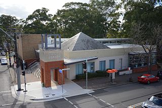
Hornsby is a suburb on the Upper North Shore of Sydney in the Australian state of New South Wales 19 kilometres (12 mi) north-west of the Sydney central business district. It is the administrative centre of the local government area of Hornsby Shire.

Epping is a suburb of Sydney, in the Australian state of New South Wales, 18 kilometres north-west of the Sydney central business district in the local government area of the City of Parramatta. Epping is located in the Northern Suburbs and Greater Western regions of Sydney.

The Hills Shire is a local government area in the Greater Western Sydney region of Sydney, New South Wales, Australia. The suburb is north-west of the Sydney central business district, and encompasses 401 square kilometres (155 sq mi) stretching from the M2 Hills Motorway in the south to Wiseman's Ferry on the Hawkesbury River in the north. The Hills Shire had a population of 157,243 as at the 2016 census.

Hornsby Shire is a local government area situated on the Upper North Shore and Northern Suburbs of Sydney, as well as parts of the Hills District, in the state of New South Wales, Australia. The shire stretches from the M2 Hills Motorway in the south to the Hawkesbury River town of Wisemans Ferry, some 53 kilometres (33 mi) to the north, making it the largest local government council in the Greater Sydney Metropolitan region by total area. As of the 2016 census the shire had an estimated population of 142,667.
Pennant Hills is a suburb in the Northern Suburbs and Hills District of Sydney, New South Wales, Australia. Pennant Hills is located 20 kilometres north-west of the Sydney central business district in the local government area of Hornsby Shire.

Thornleigh is a suburb on the Upper North Shore and Northern Suburbs of Sydney in the state of New South Wales, Australia. Thornleigh is located 22 kilometres north-west of the Sydney central business district in the local government area of Hornsby Shire. The source of the Lane Cove River is located in Thornleigh.
Westleigh is a suburb of northern Sydney, in the state of New South Wales, Australia 22 kilometres north-west of the Sydney central business district in the local government area of Hornsby Shire. Westleigh is part of the Northern Suburbs of Sydney.

Yarrawarrah is a suburb in southern Sydney, in the state of New South Wales, Australia 32 kilometres south of the Sydney central business district, in the local government area of the Sutherland Shire.

Galston is a semi-rural town located in the Hornsby District of Sydney, in the state of New South Wales, Australia. Galston is located from the city at 36 kilometres north-west of the Sydney central business district, in the local government area of the Hornsby Shire. Galston is in the NSW state electoral district of Hornsby and Federal division of Berowra. Galston is situated 16 minutes away from the suburb of Hornsby.
Mount Kuring-gai is a suburb of northern Sydney, in the state of New South Wales, Australia. Mount Kuring-gai is located 31 kilometres north-west of the Sydney central business district, in the local government area of Hornsby Shire.
The Darkinjung are the Local Aboriginal Land Council in the Wyong and Gosford Shire Council area and is a major landowner on the Central Coast, participating in formal joint management of some areas of state forest in the region. It represents over 450 local Aboriginal residents. The Darkinjung Local Aboriginal Land Council are self-appointed caretakers of the Central Coast of NSW Australia. They do not claim to be the traditional owners of the area in which they reside. Indigenous history and Traditional Owners of the Gosford and Wyong Shires Office], Bungaree, Guringai Guringai.

Hornsby Heights is a suburb of northern Sydney, in the state of New South Wales, Australia. Hornsby Heights is located 20 kilometres north-west of the Sydney central business district, in the local government area of Hornsby Shire.

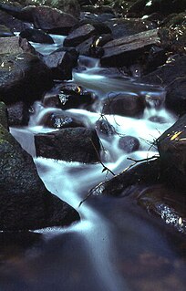
The Berowra Creek, a watercourse that is part of the Hawkesbury-Nepean catchment, is located to the north of the Sydney central business district in the Hornsby Shire of New South Wales, Australia.

The Muogamarra Nature Reserve is a protected nature reserve that is located in the Sydney region of New South Wales, in eastern Australia. The 2,274-hectare (5,620-acre) reserve is situated in the northern edge of Sydney and lies between the suburb of Cowan to the south, and the Hawkesbury River to the north.

The Cumberland Plain is a relatively flat region lying to the west of Sydney CBD in New South Wales, Australia. Cumberland Basin is the preferred physiographic and geological term for the low-lying plain of the Permian-Triassic Sydney Basin found between Sydney and the Blue Mountains, and it is a structural sub-basin of the Sydney Basin.
The Bidjigal Reserve is a 186 hectare reserve in New South Wales, Australia. It lies predominantly within The Hills Shire, with a small section south of the M2 Motorway in the City of Parramatta. The reserve lies in the suburbs of North Rocks, Northmead, Baulkham Hills, Castle Hill, West Pennant Hills, and Carlingford. The reserve lies south of Richard Webb Reserve in West Pennant Hills, with the majority located to the north of the M2 Motorway.
The Worimi conservation lands are located on and adjacent to Stockton Beach in New South Wales, Australia. They were created in February 2007 when Crown land at Stockton Bight was granted to the Worimi Local Aboriginal Land Council. The lands were then leased back to the NSW Government as three conservation reserves covering an area of 4,436 ha. Day to day management of the Worimi conservation lands is undertaken by the NSW National Parks and Wildlife Service.

Devlins Creek, an urban watercourse that is part of the Parramatta River catchment, is located in Northern Suburbs region of Sydney, Australia.
Terrys Creek, an urban watercourse that is part of the Lane Cove River catchment, is located in Northern Suburbs region of Sydney, Australia. It was named after Edward Terry who served as the first mayor of Eastwood municipality.

The Berowra Valley National Park is a protected national park that is located in northern Sydney, New South Wales, Australia. The 3,884-hectare (9,600-acre) national park is situated approximately 20 kilometres (12 mi) north-west of the Sydney central business district. Located within the Sydney Basin, the park is part of the dissected Hornsby Plateau which is dominated by Hawkesbury Sandstone and predominately covers the catchment area of Berowra Creek.

