Astrolabe Park

Last updated

Astrolabe Park
AstrolabePark.jpg
View from Astrolabe Park looking towards the Botany Dams
Astrolabe Park
LocationAstrolabe Road, Daceyville New South Wales, Australia
Nearest citySydney
Coordinates 33°55′46″S151°13′21″E / 33.92951319314129°S 151.22243355339094°E / -33.92951319314129; 151.22243355339094
Area9.17 hectares (22.7 acres)
Created1934 (1934)
Operated by Bayside Council and Sydney Water
Open24 hours
StatusOpen all year
Public transit access
  • TfNSW B.svg : Route #342
  • TfNSW L.svg : Juniors Kingsford

Astrolabe Park is a 9.17-hectare (23-acre) public park in the Eastern Suburbs of Sydney, New South Wales, Australia.

Contents

Astrolabe Park is located south-east of Sydney CBD in the heritage suburb of Daceyville, and the park is also part of the heritage listed Botany Water Reserves. [1]

Features

Astrolabe Park is a public park with a half basketball court, walking track, and public toilets. The entire park is also an off-leash area for dogs.

In the south-west corner of Astrolabe Park there is a viewing area of the Botany Dams, with a plaque illustrating the aquifer system which runs underground from Centennial Park to Botany Bay.

History

Astrolabe Park was formally created as a public recreation reserve in 1934. [2] In the 1910s, when Daceyville was initially being constructed, the parklands were a swamp.

Astrolabe Park is named after the French ship Astrolabe, which explored Botany Bay in 1788, just a few days after the arrival of the First Fleet.

Astrolabe Park was partly used as a municipal landfill site for the City of Botany Bay beginning in 1938 and continuing intermittently until 1978. The area was also mined for sand throughout the 1950s and 60s. [3]

In 1979, Botany Council constructed public tennis courts at Astrolabe Park and at Mutch Park. [4] However, the tennis courts at Astrolabe Park were removed in the early 1990s and replaced with a half basketball court.

In the 1980s and 1990s, Astrolabe Park had a BMX track. [5] Remnants of the track remain in the northwest corner of the park.

Community

Friends of Astrolabe Park is a local community group formed to help protect and improve Astrolabe Park. [6] [7]

Controversies

In 1992, the NSW State Government wanted to perform sand mining at Bonnie Doon Golf Club, and a proposal was made to give all the land at Astrolabe Park to Bonnie Doon Golf Course so that they could build 6 more golfing holes there. Botany Council objected to this proposal, saying that "the permanent alienation of any section of Astrolabe Park clearly would adversely affect the recreational usage of the park by community and particularly the schools in the area". Botany Council also commented that Astrolabe Park should be protected and preserved as it was "well located to provide pedestrian access to residents of Daceyville without the necessity of crossing major roads". [5]

In 2015, Football NSW proposed building a synthetic field at Astrolabe Park to be used for soccer games. This plan was abandoned. [8]

In 2017, Sydney Water was considering transferring ownership of Astrolabe Park to Bayside Council, and the council was developing a new master plan for the park. However, Bayside Council never released a master plan for Astrolabe Park, and Sydney Water has retained ownership of the park. [9]

In 2018, the University of New South Wales tried to redevelop Astrolabe Park into privately owned sporting fields, in a consortium with Cricket NSW and AFL NSW. [10] This plan was abandoned after widespread opposition from the local community. [7]

Also in 2018, a separate proposal was made by the Sydney International Beach Volleyball Centre Consortium, to build a private volleyball stadium at Astrolabe Park. [10] Meredith Wallace of Bayside Council describe this proposal as "unbelievably terrible", and this plan was also abandoned. [11]

In 2022, the University of New South Wales and NSW Rugby proposed holding public rugby matches with 5,000 attendees at the adjacent and privately operated David Phillips Field, and using the grass at Astrolabe Park as a parking lot for those matches. [12] Their application was refused by Bayside Council, and refused again on appeal. [13] NSW Rugby lodged another appeal in November 2023, this time to the Land and Environment Court of New South Wales.

Related Research Articles

<span class="mw-page-title-main">City of Botany Bay</span> Former local government area in New South Wales, Australia

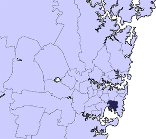
The City of Botany Bay was a local government area in the inner southern and south-eastern region of Sydney, in the state of New South Wales, Australia. The area encompassed the suburbs to the north of Botany Bay, such as Botany. First proclaimed in 1888 as the "Borough of Botany", the council became the "Municipality of Botany" from 1906 to 1996, when it was proclaimed a city as the "City of Botany Bay".

<span class="mw-page-title-main">Mascot, New South Wales</span> Suburb of Sydney, New South Wales, Australia

Mascot is an inner south and west suburb of Sydney, in the state of New South Wales, Australia. Mascot is located 7 kilometres south of the Sydney central business district and is one of the administrative centres of the Bayside Council. A small part of Mascot is located in the Inner West Council. Mascot is on the north-west side of Botany Bay and contains Sydney Airport.

<span class="mw-page-title-main">La Perouse, New South Wales</span> Suburb of Sydney, New South Wales, Australia

La Perouse is a suburb in the Eastern Suburbs of Sydney, in the state of New South Wales, Australia. The suburb of La Perouse is located about 14 kilometres (8.7 mi) southeast of the Sydney central business district, in the City of Randwick.

<span class="mw-page-title-main">Botany, New South Wales</span> Suburb of Sydney, New South Wales, Australia

Botany is a suburb in the Eastern Suburbs of Sydney, in the state of New South Wales, Australia. Botany is located 11 kilometres south of the Sydney central business district and is part of the Bayside Council.

<span class="mw-page-title-main">Eastern Suburbs (Sydney)</span> Region in New South Wales, Australia

The Eastern Suburbs is the eastern metropolitan region of Sydney, New South Wales, Australia.

<span class="mw-page-title-main">Sutherland Shire</span> Local government area in New South Wales, Australia

Sutherland Shire is a local government area in the southern region of Sydney, in the state of New South Wales, Australia. The Sutherland Shire is located just south of the Sydney CBD, and comprises an area of 370 square kilometres (140 sq mi) and as at the 2016 census and has an estimated population of 218,464. The Sutherland Shire is colloquially known as "The Shire" which has been featured in several reality television series.

<span class="mw-page-title-main">Brighton-Le-Sands, New South Wales</span> Suburb of Sydney, New South Wales, Australia

Brighton Le Sands, is a suburb in southern Sydney, in the state of New South Wales, Australia. Brighton Le Sands is located 13 kilometres south of the Sydney central business district, on the western shore of Botany Bay. Brighton Le Sands is in the local government area of the Bayside Council and is part of the St George area.

<span class="mw-page-title-main">Kingsford, New South Wales</span> Suburb of Sydney, New South Wales, Australia

Kingsford is a suburb in the Eastern Suburbs of Sydney, in the state of New South Wales, Australia. Kingsford is located 7 kilometres south-east of the Sydney central business district, in the local government area of the City of Randwick. Kingsford is part of the Eastern Suburbs region.

<span class="mw-page-title-main">Division of Kingsford Smith</span> Australian federal electoral division

The Division of Kingsford Smith is an Australian electoral division in the state of New South Wales. The division is located south and south-east of Sydney CBD, comprising mostly City of Randwick and the suburbs of Bayside Council that were governed by the former City of Botany Bay.

<span class="mw-page-title-main">Pagewood, New South Wales</span> Suburb of Sydney, New South Wales, Australia

Pagewood is a suburb in the Eastern Suburbs of Sydney, in the state of New South Wales, Australia, 8 kilometres south of the Sydney central business district. It is part of the Bayside Council.

<span class="mw-page-title-main">Little Bay, New South Wales</span> Suburb of Sydney, New South Wales, Australia

Little Bay is a suburb in the Eastern Suburbs of Sydney, in the state of New South Wales, Australia. Little Bay is located 14 kilometres south-east of the Sydney central business district and is part of the local government area of the City of Randwick.

<span class="mw-page-title-main">Banksmeadow</span> Suburb of Sydney, New South Wales, Australia

Banksmeadow is a suburb located in the Eastern Suburbs of Sydney, within the state of New South Wales, Australia. Situated 11 kilometres south of the Sydney central business district, it falls under the jurisdiction of the Bayside Council. Banksmeadow is positioned on the northern shores of Botany Bay.

<span class="mw-page-title-main">Daceyville</span> Suburb of Sydney, New South Wales, Australia

Daceyville is a suburb in the Eastern Suburbs of Sydney, in the state of New South Wales, Australia. Daceyville is 7 km south of the Sydney central business district and is now part of Bayside Council.

<span class="mw-page-title-main">Eastlakes, New South Wales</span> Suburb of Sydney, New South Wales, Australia

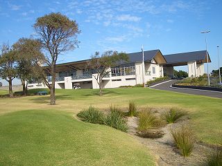
Eastlakes is an inner southern and eastern suburb of Sydney, in the state of New South Wales, Australia. Eastlakes is located 8 kilometres south of the Sydney central business district, in the local government area of the Bayside Council, Eastlakes is mostly residential with a shopping centre located at Evans Avenue. The residential portion of the suburb falls in the inner south being west of the Eastern Distributor while the non-residential side of the suburb consisting of The Lakes Golf Course and Botany Dams is east of the Eastern Distributor falling within the Eastern Suburbs, south-east of the CBD.

Ron Hoenig is an Australian barrister and current member for Heffron in the New South Wales Legislative Assembly. He is currently the Minister for Local Government, Vice-President of the Executive Council, and Leader of the House, in the NSW Labor Government of Premier Chris Minns. He previously served as Mayor of the City of Botany Bay in New South Wales from 1981 to 2012, a record 31 years, before standing down and winning the 25 August Heffron by-election in the state parliament for the Labor Party.

<span class="mw-page-title-main">Georges River Council</span> Local government area in New South Wales, Australia

Georges River Council is a local government area located in the St George region of Sydney located south of the Sydney CBD, in New South Wales, Australia. The Council was formed on 12 May 2016 from the merger of the Hurstville City Council and Kogarah City Council.

<span class="mw-page-title-main">Bayside Council</span> Local government area in New South Wales, Australia

Bayside Council is a local government area in Sydney, New South Wales, Australia. It is located around part of Botany Bay, 7 kilometres (4.3 mi) to 12 kilometres (7.5 mi) south of the Sydney CBD. It includes suburbs of Southern Sydney as well as a small portion in the Eastern suburbs, south-east of the Sydney CBD. It comprises an area of 50 square kilometres (19 sq mi) and as at the 2016 census had a population of 156,058.

<span class="mw-page-title-main">Botany Water Reserves</span> Historic site in New South Wales, Australia

The Botany Water Reserves are a heritage-listed former water supply system and now parkland and golf course at 1024 Botany Road, Mascot, Bayside Council, Sydney, New South Wales, Australia. It was designed by City Engineers, W. B. Rider, E. Bell (1856–1871), and Francis Bell (1871–1878). It is also known as Botany Dams, Botany Swamps, Botany Wetlands, Mill Stream, Bridge Pond, Lakes Golf Course, Eastlakes Golf Course, Bonnie Doon Golf Club, and Astrolabe Park. The property is owned by Sydney Water, an agency of the Government of New South Wales. It was added to the New South Wales State Heritage Register on 18 November 1999.

<span class="mw-page-title-main">Woollahra Reservoir</span> Historic site in New South Wales, Australia

The Woollahra Reservoir or WS022 is a heritage-listed underground reservoir at 5R Oxford Street, Centennial Park, New South Wales, Australia. It was designed and built by the NSW Public Works Department. The property is owned by Sydney Water. A sign attached to a building on the site states that this is known as "Centennial Park number 1 Water Reservoir Underground WS0022". The reservoir is adjacent to Centennial Park Reservoir. This reservoir is closer to York Street than Centennial Park Reservoir. The area is enclosed by a high fence and a sign on the main gate states: WARNING KEEP OUT" and that trespassers may be prosecuted.

<span class="mw-page-title-main">Botany Sands Aquifer</span> Aquifer in New South Wales, Australia

The Botany Sands Aquifer is an aquifer that surrounds Botany Bay just south of Sydney, New South Wales, Australia. A former main water source for Sydney, it stretches from Centennial Park south east of Sydney CBD into Botany Bay to the south. The aquifer is chiefly filled by rainfall, some contributions from irrigation, seeping service mains and flow from the subjacent bedrock units.

References

  1. "Plan of Management: Botany Wetlands 2018–2028" (PDF). Retrieved 27 June 2022.
  2. "Assignment of Names to Reserve Trusts". Government Gazette of the State of New South Wales . No. 14. New South Wales, Australia. 10 February 1995. p. 752 via Trove.
  3. Acworth, R.I.; Jorstad, L.B. (2006). "Integration of multi-channel piezometry and electrical tomography to better define chemical heterogeneity in a landfill leachate plume within a sand aquifer". Journal of Contaminant Hydrology. 83 (3–4): 200–220. doi:10.1016/j.jconhyd.2005.11.007. PMID   16412530.
  4. Robertson, Rosanne (24 September 1987). "No frills Mayor went to council by ute". The Eastern Herald. p. 32.
  5. 1 2 Horrigan, Darren (7 May 1992). "State Wants Golf Course". The Sydney Morning Herald. p. 3.
  6. Friends of Astrolabe Park
  7. 1 2 James, Ben (4 September 2018). "Park plan scrapped". Southern Courier (New South Wales). p. 15.
  8. Meeting the Future Needs of Football in NSW: A Partnership Approach, May 2015
  9. "Bayside Council S7.11 Development Contributions Plan 2016 (PDF), 2016
  10. 1 2 Gorrey, Megan (27 June 2018). "Dog-friendly park under threat as sports teams weigh move from stadium". Sydney Morning Herald .
  11. "Residents in show of strength over Astrolabe Park". The Daily Telegraph (New South Wales). 23 July 2018.
  12. DA-2022/164 Development Application - Permit use of NSW Rugby Centre of Excellence by the general public, 3 June 2022
  13. S82-2023/3 S8.2 Review of Determination - Review of Determination of DA-2022/164, 21 October 2023