Avalon Beach, New South Wales

Last updated

Avalon Beach
Sydney,  New South Wales
Avalon beach-1w.jpg
Avalon Beach, looking north
Avalon Beach, New South Wales
Population10,379 (SAL 2021) [1]
Established1921
Postcode(s) 2107
Elevation9 m (30 ft)
Location28 km (17 mi) north of Sydney CBD
LGA(s) Northern Beaches Council
State electorate(s) Pittwater
Federal division(s) Mackellar
Suburbs around Avalon Beach:
Careel Bay Palm Beach Whale Beach
Clareville Avalon Beach Tasman Sea
Bilgola Newport Tasman Sea

Avalon Beach is a northern beachside suburb of Sydney, in the state of New South Wales, Australia. It is 28 kilometres north of the Sydney central business district, in the local government area of Northern Beaches Council, in the Northern Beaches region. The area was previously called Avalon, with the name Avalon Beach being assigned during a change in boundaries and names in the Pittwater region in 2012. [2]

Contents

History

The Pittwater and Northern Beaches area was formerly inhabited by the Garigal or Caregal people in a region known as Guringai country. [3]

European settlement

Avalon was named after the mythical Avalon, a legendary island in Celtic languages mythology. According to legends, Avalon was an earthly paradise and the final resting place of King Arthur. [4]

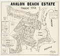
The first land grant in the area was 240,000 square metres (60 acres) to John Farrell in 1827. In 1833 a 4.9-square-kilometre (1,200-acre) land grant was made to Australia's first Catholic priest, John Joseph Therry, by Governor Bourke. A further grant of 280 acres made in 1837 meant that Therry's holdings covered most of the peninsula from Newport to Whale Beach. [5] He built a church in this area but his plans for a settlement never eventuated. Therry fought hard for the recognition of the Catholic Church in the colony. After he died, the land was left to the Jesuit order and was then sold to help finance the rebuilding of St. Mary's Cathedral in Sydney. [6] In the 1920s, the area was still known as 'Priest's Flat'. Arthur J Small handled a subdivision in 1921 and chose the name Avalon. [4] Lots were sold for £100 each and included two year's free membership in the local golf club. [6]

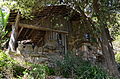
Significant housing developments took place during the 1920s. The architect Alexander Stewart Jolly designed a number of houses that were built in the Avalon area in that period. Loggan Rock was a flamboyant log cabin combined with a stone tower; the combination of logs and rocks gave rise to the name. The house is heritage-listed. [7] Careel House is a bungalow made of stone that was quarried in the area. Nowadays it is on the Whale Beach side of the boundary. It is also heritage-listed. [8] Hy Brasil, located near Clareville, was built in 1936, but was originally known as The Gem. Later it was bought by Ted Herman, son of the painter Sali Herman, who changed the name, using the name of a mythical island west of Ireland. It is heritage-listed. [9] A sandstone cottage known as Wickham, designed by Walter Burley Griffin, was demolished with council approval in 1994.

Another significant development was the creation of Ruskin Rowe in 1950. This street was designed as an estate by the architect Harry Ruskin Rowe, son of the architect Thomas Rowe. Rowe created covenants to preserve the character of the estate, but they have been ignored to an extent over the years. Nevertheless, the estate is heritage-listed because of its historic significance, as well as its scientific significance in preserving the bushland environment of the area. [10]

Early subdivision plans

Heritage listings

Avalon Beach has a number of heritage-listed sites, including:

Demographics

According to the 2021 census of population, there were 10,379 residents in Avalon Beach. 74.1% of people were born in Australia. The next most common countries of birth were England 9.5%, New Zealand 1.9% and United States of America 1.4%. 91.0% of people only spoke English at home. The most common responses for religious affiliation were No Religion 53.5%, Catholic 16.7% and Anglican 15.2%. [13]

Commercial areas

Avalon Beach features an RSL club, a surf club, bowling and sailing clubs; a golf club, a supermarket, shops, offices, cafes and a cinema. Cuisines include French, [14] Vietnamese, Italian, [15] Mexican, American Diner, Japanese, [16] Thai and other Asian. There is a book shop, hairdresser, artisan bakery, petrol station, Red Cross Shop, bottle shop, many real estate agents, hardware store, florists and many homewares and dress shops. It is unique in that this large commercial centre is separated from the beach only by the road, a fact which until recently was used to argue against commercialisation of the beach side buildings themselves as restaurants and cafes were already so close to the beach.

Sport and recreation

Avalon Beach is a surfing beach and has a 25-metre salt water rock pool at the south end. It is renowned for its rich orange-coloured sand (that indicate the presence of iron oxide), which contrasts to the typical yellow coloured beaches in the eastern suburbs. [17] Avalon Beach SLSC members patrol Avalon Beach. [18] Several former surfing world champions are also past or current Avalon residents, including Ben Player.

Avalon Soccer Club, established 1982, has over 80 teams and 1000 registered players. Avalon Junior Rugby League Club has contributed several players active in the Australian National Rugby League. Avalon also has a small nine-hole golf course.

The former Pittwater Council created the Bangalley Headland Bicentennical Walk, which goes through part of the Careel Headland Reserve. The track starts at Whale Beach Road and goes to Marine Parade. The council also proposed a Plan of Management for the Bicentennial Walk in 2001, and adopted it in 2002. [19] St Michaels Cave is an interesting coastal feature.

Schools

Culture/politics

An episode of the American television show Baywatch was shot at Avalon Beach in the late 1990s. Producers of the show, seeking to relocate from their Californian base due to cost constraints, proposed a full relocation to Avalon and promised an upgrading of the SLSC in return, painting a huge sign saying "Avalon Beach" across the surf club. However, following complaints from residents (supported by former world surfing champion and local property owner Mark Warren), the series moved instead to Hawaii. The anti-Baywatch supporters were led by former Pittwater mayor Alex McTaggart, who was subsequently elected to NSW State Parliament for two years.

In 2011-13 there was a move by the Avalon Beach Surf Life Saving club officials, led by Christine Hopton, to replace the existing surf club. The development went ahead despite opposition from local residents in the land and environment court.

Australian drama series Blue Water High was set at Avalon Beach, and the series was filmed there.

Notable residents

Related Research Articles

<span class="mw-page-title-main">Ku-ring-gai Chase National Park</span> Protected area in New South Wales, Australia

Ku-ring-gai Chase National Park is a national park on the northern side of Sydney in New South Wales, Australia. The 14,977-hectare (37,010-acre) park is 25 kilometres (16 mi) north of the Sydney central business district and generally comprises the land east of the M1 Pacific Motorway, south of the Hawkesbury River, west of Pittwater and north of Mona Vale Road. It includes Barrenjoey Headland on the eastern side of Pittwater.

<span class="mw-page-title-main">Palm Beach, New South Wales</span> Suburb of Sydney, New South Wales, Australia

Palm Beach is a suburb in the Northern Beaches region of Greater Sydney, in the state of New South Wales, Australia. Palm Beach is located 41 kilometres (25 mi) north of the Sydney central business district, in the local government area of Northern Beaches Council. Palm Beach sits on a peninsula at the end of Barrenjoey Road near Pittwater and is the northernmost beach in the Greater Sydney Metropolitan area. The population of Palm Beach was 1,593 as at the 2016 census.

<span class="mw-page-title-main">Northern Beaches</span> Region in New South Wales, Australia

The Northern Beaches is a region within Northern Sydney, in the state of New South Wales, Australia, near the Pacific coast. This area extends south to the entrance of Port Jackson, west to Middle Harbour and north to the entrance of Broken Bay. The area was formerly inhabited by the Garigal or Caregal people in a region known as Guringai country.

<span class="mw-page-title-main">Whale Beach, New South Wales</span> Suburb of Sydney, New South Wales, Australia

Whale Beach is a northern beachside suburb of Sydney, in the state of New South Wales, Australia. Whale Beach is located 40 kilometres north of the Sydney central business district, in the local government area of Northern Beaches Council, in the Northern Beaches region.

<span class="mw-page-title-main">Pittwater Council</span> Former local government area in New South Wales, Australia

Pittwater Council was a local government area on the Northern Beaches of Sydney, in the state of New South Wales, Australia. It covered a region adjacent to the Tasman Sea about 30 kilometres (19 mi) north of the Sydney central business district. The area is named after Pittwater, the body of water adjacent to much of the area governed. First proclaimed in 1906 as the A Riding of Warringah Shire, the area was proclaimed as the Municipality of Pittwater on 1 May 1992. On 12 May 2016, the Minister for Local Government announced that Pittwater Council would be subsumed into the newly formed Northern Beaches Council. The last mayor of Pittwater Council was Councillor Jacqui Townsend, an independent politician.

<span class="mw-page-title-main">Broken Bay</span> Bay in New South Wales, Australia

Broken Bay, a semi-mature tide-dominated drowned valley estuary, is a large inlet of the Tasman Sea located about 50 kilometres (31 mi) north of Sydney on the Central Coast of New South Wales, Australia; being one of the bodies of water that separate greater Metropolitan Sydney from the Central Coast. Broken Bay is the first major bay north of Sydney Harbour in the state capital of Sydney.

<span class="mw-page-title-main">Dee Why</span> Suburb of Sydney, New South Wales, Australia

Dee Why is a coastal suburb of northern Sydney, in the state of New South Wales, Australia, 18 kilometres north-east of the Sydney central business district. It is the administrative centre of the local government area of Northern Beaches Council and, along with Brookvale, is considered to be the main centre of the Northern Beaches region.

<span class="mw-page-title-main">Pittwater</span> Estuary in Sydney, Australia

Pittwater is a semi-mature tide dominated drowned valley estuary, located about 40 kilometres (25 mi) north of the Sydney central business district, New South Wales, Australia; being one of the bodies of water that separate greater Metropolitan Sydney from the Central Coast.

<span class="mw-page-title-main">Queenscliff, New South Wales</span> Suburb of Sydney, New South Wales, Australia

Queenscliff is a suburb of northern Sydney, in the state of New South Wales, Australia. Queenscliff is located 16 kilometres north-east of the Sydney central business district, in the local government area of Northern Beaches Council and is part of the Northern Beaches region.

<span class="mw-page-title-main">Newport, New South Wales</span> Suburb of Northern Beaches Council, New South Wales, Australia

Newport is a suburb of northern Sydney in the state of New South Wales, Australia, in the local government area of Northern Beaches Council. It is part of the Northern Beaches region.

<span class="mw-page-title-main">Bilgola Beach, New South Wales</span> Suburb of Sydney, New South Wales, Australia

Bilgola Beach is a suburb in Sydney's Northern Beaches in the state of New South Wales, Australia. Bilgola Beach is 33 kilometres north-east of the Sydney central business district, in the local government area of Northern Beaches Council. It and Bilgola Plateau were gazetted as suburbs in 2012, dividing the previous suburb of Bilgola.

<span class="mw-page-title-main">Bilgola Plateau, New South Wales</span> Suburb of Sydney, New South Wales, Australia

Bilgola Plateau is a suburb in Sydney's Northern Beaches in the state of New South Wales, Australia.

<span class="mw-page-title-main">Careel Bay</span> Bay and locality in Sydney, Australia

Careel Bay is a bay and adjacent locality in Sydney, New South Wales, Australia. The locality is within the suburb of Avalon Beach. The bay lies adjacent to the suburbs of Avalon Beach and Palm Beach in the north east of Pittwater.

<span class="mw-page-title-main">Clareville, New South Wales</span> Suburb of Sydney, New South Wales, Australia

Clareville is a suburb in northern Sydney, in the state of New South Wales, Australia. Clareville is 36 kilometres north-east of the Sydney central business district, in the local government area of Northern Beaches Council. Clareville is part of the Northern Beaches region.

<span class="mw-page-title-main">Barrenjoey, New South Wales</span>

Barrenjoey is a locality in the suburb of Palm Beach, at the most northern tip of Pittwater. The headland is made up primarily of sandstones of the Newport Formation, the top third is a cap of Hawkesbury sandstone. Around 10,000 years ago the headland was cut off from the mainland due to the rising sea level; subsequent buildup of a sand spit or tombolo reconnected the island to the mainland. It is the location of the Barrenjoey Head Lighthouse, a lighthouse that was first lit in 1881. In 1995 Barrenjoey was gazetted into Ku-ring-gai Chase National Park.

<span class="mw-page-title-main">Barrenjoey Road</span> Road in Sydney, Australia

Barrenjoey Road is a main urban road along the northern coast of the Northern Beaches suburbs of Sydney, Australia. In 1978, the Barrenjoey Road area came to national attention due to the unsolved disappearance of Trudie Adams.

<span class="mw-page-title-main">Barrenjoey Head Lighthouse</span> Lighthouse in New South Wales, Australia

The Barrenjoey Head Lighthouse is a heritage-listed lighthouse at Barrenjoey Headland in the Sydney suburb of Palm Beach, New South Wales, Australia. It was designed by James Barnet, the New South Wales Colonial Architect and built by Isaac Banks. It is also known as Barrenjoey Head Lightstation. The property is owned by Office of Environment and Heritage, an agency of the Government of New South Wales. The lightstation was added to the New South Wales State Heritage Register on 2 April 1999.

Alexander Stewart Jolly (1887–1957) was a Sydney-based architect, published poet and children's author in the early 20th century. His buildings are primarily in Sydney's northern suburbs and the north coast of New South Wales. His architectural work was strongly influenced by Frank Lloyd Wright’s School in Chicago, as well as the Arts and Crafts movement of the time.

<span class="mw-page-title-main">Northern Beaches Council</span> Local government area in New South Wales, Australia

The Northern Beaches Council is a local government area located in the Northern Beaches region of Sydney, in the state of New South Wales, Australia. The council was formed on 12 May 2016 after the amalgamation of Manly, Pittwater, and Warringah councils.

<span class="mw-page-title-main">Loggan Rock</span> Historic site in New South Wales, Australia

Loggan Rock is a heritage-listed residential building located at 111 Whale Beach Road, Avalon Beach, Northern Beaches Council, New South Wales, Australia. It was designed in 1929 by Alexander Stewart Jolly in the Californian Bungalow style, with a 1953 modern extension designed by Max Collard. The house was built from 1929 to 1953. The house is also known as Cabin Avalon and Log and Rock; and it was added to the New South Wales State Heritage Register on 15 August 2008.

References

  1. Australian Bureau of Statistics (28 June 2022). "Avalon Beach (suburb and locality)". Australian Census 2021 QuickStats. Retrieved 28 June 2022.  OOjs UI icon edit-ltr-progressive.svg
  2. Pearce, Greg. "Avalon Beach And Bilgola Beach Approved". Archived from the original on 4 April 2015. Retrieved 23 April 2015.
  3. "Aborigines". Pittwater Library. Retrieved 9 October 2014.
  4. 1 2 The Book of Sydney Suburbs, Compiled by Frances Pollon, Angus & Robertson Publishers, 1990, Published in Australia ISBN   0-207-14495-8, page 13
  5. Messent, David (1999). Sydney's Northern Beaches. Sydney: David Messent Photography. p. 127. ISBN   0-9577124-05.
  6. 1 2 Messent, David (1999). Sydney's Northern Beaches. Sydney: David Messent Photography. p. 128. ISBN   0-9577124-05.
  7. State Heritage Website
  8. State Heritage Website
  9. State Heritage Website
  10. State Heritage Website
  11. "Walter Burley Griffin Lodge". New South Wales State Heritage Register . Department of Planning & Environment. H01510. Retrieved 18 May 2018. CC BY icon.svg Text is licensed by State of New South Wales (Department of Planning and Environment) under CC-BY 4.0 licence .
  12. "Loggan Rock". New South Wales State Heritage Register . Department of Planning & Environment. H01779. Retrieved 18 May 2018. CC BY icon.svg Text is licensed by State of New South Wales (Department of Planning and Environment) under CC-BY 4.0 licence .
  13. Australian Bureau of Statistics (28 June 2022). "Avalon Beach (State Suburb)". 2021 Census QuickStats. Retrieved 3 August 2024. OOjs UI icon edit-ltr-progressive.svg
  14. "Bistro Boulevard Website". Archived from the original on 27 February 2021.
  15. "Pizzico Website". Archived from the original on 22 March 2020.
  16. "Ninja Japanese Restaurant Website". Archived from the original on 25 January 2011.
  17. The northern beaches from the air by Kathryn Welling from The Manly Daily
  18. "Avalon Beach Surf Life Saving Club". Avalonbeachslsc.com.au. 17 January 2010. Retrieved 27 January 2010.
  19. "BANGALLEY HEADLAND RESERVE AND NORTH AVALON HEADLAND PLAN OF MANAGEMENT" (PDF). 24 July 2001. Archived (PDF) from the original on 11 August 2021. Retrieved 12 August 2021.

33°38′01″S151°19′57″E / 33.63358°S 151.33257°E / -33.63358; 151.33257