Geography of Sydney

Last updated

Sydney as viewed from Tasman Sea, overlooking the sandstone cliffs in Vaucluse Sydneycityscape.jpg
Sydney as viewed from Tasman Sea, overlooking the sandstone cliffs in Vaucluse
Satellite photo of the Sydney area ISS022-E-75960 - View of New South Wales.jpg
Satellite photo of the Sydney area

The geography of Sydney is characterised by its coastal location on a basin bordered by the Pacific Ocean to the east, the Blue Mountains to the west, the Hawkesbury River to the north and the Woronora Plateau to the south. Sydney lies on a submergent coastline on the east coast of New South Wales, where the ocean level has risen to flood deep river valleys (rias) carved in the Sydney sandstone. Port Jackson, better known as Sydney Harbour, is one such ria. [1]

Contents

The Sydney area lies on Triassic shales and sandstones. The region mostly consists of low rolling hills and wide valleys in a rain shadow area that is shielded by the Great Dividing Range. [2] Sydney sprawls over two major regions: the Cumberland Plain, a relatively flat region lying to the west of Sydney Harbour, and the Hornsby Plateau, a plateau north of the Harbour rising to 200 metres and dissected by steep valleys. [3] Sydney's native plant species are predominantly eucalyptus trees, [4] and its soils are usually red and yellow in texture. The endemic flora is home to a variety of bird, insect, reptile and mammal species, which are conspicuous in urban areas. [5]

There are more than 70 harbour and ocean beaches in the urban area. Most of Sydney's water storages are on tributaries of the Nepean River. Parramatta River drains a large area of Sydney's western suburbs. [6] With 5,005,400 inhabitants (as of 2016) and an urban population density of 2037 people per square kilometre, Sydney's urban area covers 1,788 km2 (690 sq mi), [7] comprising 35% of Sydney and is constantly growing. [8]

Greater Sydney's boundaries stretch 80 kilometres (50 mi) from Palm Beach in the north to the Royal National Park in the south, and 80 kilometres (50 mi) from Bondi Beach in the east to the Blue Mountains in the west.

Geology

The Sydney region includes coastal features of cliffs, beaches, estuaries and deep river valleys known as rias. Sydney(from air).jpg
The Sydney region includes coastal features of cliffs, beaches, estuaries and deep river valleys known as rias.

The rising sea level between 6,000 and 18,000 years ago flooded the rias to form estuaries and deep harbours. Erosion by coastal streams has created a landscape of deep canyons and remnant plateaus. [9] The city has fault lines which run considerably deep beneath the Sydney basin, dating back to when New Zealand started breaking away from Australia more than 85 million years ago. [10] [11] To the east the basin continues to the edge of the continental shelf. [12] The centre of the basin is located around 30 kilometres (19 mi) west of the Sydney central business district at Fairfield. [13] [14]

The sand that was to become the sandstone of today was washed from Broken Hill and laid down about 200 million years ago. The ripple marks from the ancient river that brought the grains of sand are distinctive and easily seen, telling geologists that the sand comes from rocks formed between 500 and 700 million years ago far to the south. This means that the highest part of the visible lines almost always faces approximately south. [15] There are volcanic rocks from low hills in the shale landscapes. The Basin's sedimentary rocks have been subject to uplift with gentle folding and minor faulting during the formation of the Great Dividing Range. [16]

Virtually all of Sydney's exposed rocks are sandstone (Narrabeen Group of sedimentary rocks at Narrabeen). Narrabeen Headland sedimentary rocks.JPG
Virtually all of Sydney's exposed rocks are sandstone (Narrabeen Group of sedimentary rocks at Narrabeen).

At a time in the past, monocline formed to the west of Sydney. The monocline is a sloping bend that raises the sandstone well above where it is expected to be seen, and this is why the whole of the visible top of the Blue Mountains is made of sandstone. Sandstone slopes in the Sydney area are on three sides: to the west the Blue Mountains, and to the north and south, the Hornsby and Woronora plateaux'. [17] [18] [19]

Being very porous, the Sydney sandstone has shale lenses and fossil riverbeds dotted throughout and it is some 200 metres (656 feet) thick. The sandstone was probably deposited in a freshwater delta and is the caprock which controls the erosion and scarp retreat of the Illawarra escarpment. [20] Six kilometres of sandstone and shale lie under Sydney. [21] Bringelly Shale and Minchinbury Sandstone are often seen in the greater western parts of Sydney. [22] [23] Ashfield Shale is observed in the inner western suburbs. [24] These components are part of the Wianamatta Shale group. [20] Mittagong Formation sighted in a few areas in northern Sydney. [25]

The Prospect dolerite intrusion in western Sydney is the largest assemblage of igneous rock in Sydney. The oval-shaped ridge was made many millions of years ago when volcanic material from the Earth's upper mantle moved upwards and then sideways. [26] Slow erosion of the overlying layers of sedimentary rock by the flow of rainwater have eventually laid bare the edges of the volcanic and metamorphic rocks of the intrusion. [27] The Gap, an ocean cliff on the South Head peninsula in Watsons Bay, [28] was laid as sediment more than 200 million years ago in the Triassic period. During the Jurassic era, a cataclysmic event resulted in an enormous crack forming within the strata. The Gap itself forms a sequence that continues offshore to the edge of the Sahul Shelf. [29]

Sydney features two major soils; sandy soils (such as red, brown and yellow podsols, grey and brown tenosols, lithosols, kandosols and kurosols) [30] which originate from the Hawkesbury sandstone and have low fertility, and clay soils (which are from shales and volcanic rocks), though some soils may be a mixture of the aforementioned soils (such as sandy clay loams and silty clay loam). [31] [32] [33] [34]

Sydney has a number of islands in its harbour and surrounding rivers. Such islands include, Shark Island, Cockatoo Island, Clark Island, Snapper Island, Spectacle Island and Goat Island in Port Jackson. Bare Island in Botany Bay. Lion Island, Long Island and Milson Island in Hawkesbury River. Scotland Island in the Northern Beaches. And Rodd Island in Parramatta River. [35]

Rivers and creeks

View of Nepean River from just south of Penrith Aus nsw nepean river dsc05078.jpg
View of Nepean River from just south of Penrith

Overall, Sydney has nine rivers and just over a hundred creeks. The Nepean River rises to the south in the Woronora Plateau, and wraps around the western edge of the city. Swamps and lagoons are existent on the floodplain of the Nepean River, one being Bents Basin, which is also a recreational area. Where the Nepean turns east it becomes the Hawkesbury River, which winds through the Hornsby Plateau before emptying into Broken Bay. Broken Bay and the lower Hawkesbury form the commonly accepted boundary between Sydney and the Central Coast to the north. The remaining section of Warragamba River flows 3.5 kilometres (2.2 mi) north-east from the Warragamba Dam spillway to its confluence with the Nepean River. [36]

View of Georges River as it passes through East Hills and Voyager Point Aerial View of East Hills, 2004 (19772988019).png
View of Georges River as it passes through East Hills and Voyager Point

The south and southwest of Sydney is drained by the Georges River, flowing north from its source near Appin, towards Liverpool and then turning east towards Botany Bay. The other major tributary of Botany Bay is the Cooks River, running through the inner-south western suburbs of Canterbury and Tempe. The Georges River estuary separates the main part of Sydney's urban area from the Sutherland Shire. The Woronora River, on the southern edge of the Sydney Plain, flows in a steep-sided valley from the Woronora Dam to the eastern estuary of the Georges River. The Hacking River is further south and runs through The Royal National Park into Port Hacking which forms the southern boundary of the Sutherland Shire.

Parramatta River's headwaters are several local creeks including Toongabbie Creek and Hunts Creek, part of the upper Parramatta river catchment area. Duck River is the river's southern tributary. Hunt's creek flows from Lake Parramatta, a few kilometres North of Parramatta. At east Parramatta the river becomes a tidal estuary that flows into Port Jackson, commonly known as Sydney harbour. Other major tributaries flow into Port Jackson from the North Shore and are the Lane Cove River and Middle Harbour Creek.

Minor waterways draining Sydney's western suburbs include South Creek and Eastern Creek, flowing into the Hawkesbury, and Prospect Creek draining into the Georges River. Cowan Creek and Berowra Creek run north from the Upper North Shore to the Hawkesbury river. [37]

Ecology

Parts of the North Shore and Northern Suburbs are filled with decorative street trees, including those with autumn foliage, earning the region the nickname "The Leafy North Shore". Waimea Road, Lindfield, New South Wales (2011-04-28) 04.jpg
Parts of the North Shore and Northern Suburbs are filled with decorative street trees, including those with autumn foliage, earning the region the nickname "The Leafy North Shore".

The predominant plant communities in the Sydney region are grassy woodlands, which are open woodlands scattered with sclerophyllous shrubs and sparse grass in the understory. [39] Wet and dry sclerophyll forest exist in some pockets, with heathlands and temperate/subtropical rainforests occurring in a few areas as well, thus making the Sydney region have distinct biomes. Dry sclerophyll forests, reminiscent of Mediterranean forests, are the most widespread forest type in the region, which occur sporadically in the Cumberland Plain and would feature dry, eucalyptus woodland. [40] On the other hand, wet sclerophyll forests, which fall under temperate forests, have narrow, relatively tall, dense trees with a lush, moist understorey of fleecy shrubs and tree ferns. They are found in the cooler, wetter areas such as Northern Suburbs, Forest District, North Shore and in the Blue Mountains. [41]

Sclerophyll forests developed as a result of the extreme age of the continent combined with Aboriginal fire use. Deep weathering of the crust leached chemicals out of the rock, leaving Australian soils deficient in nutrients. The sandstone is the basis of the nutrient-poor soils found in Sydney that developed over millennia and 'came to nurture a brilliant and immensely diverse array of plants'. As plants cannot afford to lose leaves to herbivores when nutrients are scarce, they defend their foliage with toxins. In eucalypts, these toxins give the bush its distinctive smell. [42] It has been calculated that around 98,000 hectares of native vegetation remains in the Sydney metropolitan area, about half of what is likely to have been existing at the time of European arrival. [43]

Bushfires semi-circling Sydney in a phenomenon known as "ring of fire". Thick bushfire smoke over Sydney, New South Wales, Australia - December 21st, 2019 (49254638462).jpg
Bushfires semi-circling Sydney in a phenomenon known as "ring of fire".

According to the Senseable City Lab at the Massachusetts Institute of Technology (MIT), which measures canopy cover in the world's most prominent cities, the Sydney area had a Green View Index of 25.9% – This represents the total percentage of the city covered by urban trees. Tying with Vancouver at that percentage, Sydney is the third prominent city in the world with the most trees after Singapore and Oslo, respectively. [45] Because the Sydney metropolitan area is encircled by a large area of bushland and forest to the north, west and south of its peripheries, [46] bushfires can ring the region during intense bushfire seasons; this natural phenomenon that surrounds Sydney has been labeled "ring of fire". [47] [48] [49] [50]

Fauna

The fauna of the Sydney area is diverse and its urban area is home to variety of bird and insect species, and also a few bat, arachnid and amphibian species. Sydney is home to dozens of bird species, which mainly include the Australian white ibis, Australian raven, Australian magpie, crested pigeon, grey butcherbird, magpie lark, noisy miner, pied currawong, silver gull and willie wagtail, among others. Introduced birds such as the house sparrow, common myna and feral pigeon are ubiquitous in the CBD areas of Sydney. [51] [52]

Moreover, possums, bandicoots, rabbits, feral cats, lizards, snakes and frogs may also be present in the urban environment, albeit seldom in city centers. [53]

Topography

The topography of the greater west is primarily grassy woodlands. Western Sydney Regional Park.jpg
The topography of the greater west is primarily grassy woodlands.

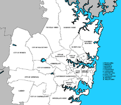
The extensive area covered by urban Sydney is formally divided into more than 650 suburbs for addressing and postal purposes, and administered as 38 local government areas. The City of Sydney itself covers a fairly small area comprising the central business district and its neighbouring inner-city suburbs. The 151st meridian east passes through the western suburbs of Granville and Revesby, among others. The suburbs to the west of those lie on the eastern end of the 150th meridian, which is a line that passes through the Russian city of Magadan in the Northern Hemisphere. [54]

The Sydney central business district (CBD) extends southwards for about 2 km (1.2 mi) from Sydney Cove, the point of the first European settlement. The west side is bounded by Darling Harbour, a popular tourist and nightlife precinct while Central station marks the southern end of the CBD. George Street serves as the Sydney CBD's main north–south thoroughfare. [55] The oldest parts of the city are located in the flat areas south of the harbour; the North Shore was slower to develop because of its hilly topography, and was mostly a quiet backwater until the Sydney Harbour Bridge was opened in 1932, linking it to the rest of the city, with the suburbs surrounding the northern entrance to said bridge effectively developing North Sydney into a second central business district. [56]

Eastern suburb of Vaucluse, which is situated on a clifftop Clifftop, hilly homes in Vaucluse in the eastern suburbs of Sydney, Australia.png
Eastern suburb of Vaucluse, which is situated on a clifftop

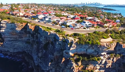
The Eastern Suburbs sit on the coast of Sydney. They contain iconic beaches such as Bondi Beach and Coogee Beach, and feature prominent seaside cliffs. The suburbs of Maroubra, Coogee and Bondi Junction lie on steep slopes, and would have an elevation of 90 metres (295 feet) at the highest peaks. These suburbs are located in generally close proximity to the city centre and are serviced by rail networks. The landscape in these areas is characterized by winding crescent-like streets with harbourside beaches and villages.

The Northern Suburbs of Sydney are characterised by pristine waterways with immense greenery and large plots of manicured land. Being around 80 to 180 metres (260 to 590 ft) above sea level, the region is very hilly and has a higher elevation than the rest of Sydney. Most of the North Shore suburbs are part of the Hawkesbury Plateau, a large sandstone plateau overlaid by a system of hilly ridges and gullies. Major waterways in the region include the Parramatta River, Lane Cove River and the many creek systems that branch out from these. The region is home to many parks and nature reserves – The Lane Cove National Park and the Garigal National Park include many areas of remnant bushland adjacent to the Lane Cove River and Middle Harbour.

Aerial view of Sydney's western suburbs surrounding Prospect reservoir (looking west of Cumberland Plain towards Blue Mountains) Aerial view of Eastern Creek, Greystanes, Horsley Park, Pemulwuy, Prospect and Wetherill Park.jpg
Aerial view of Sydney's western suburbs surrounding Prospect reservoir (looking west of Cumberland Plain towards Blue Mountains)

The Hills District, situated halfway between the northern suburbs and greater western Sydney, is a region so named for its characteristically comparatively hilly topography, akin to the Northern Suburbs and North Shore. Several of its suburbs have the word 'Hills' in their names. As the name indicates, the Hills District, depending on the suburb, is around 80 to 180 metres (260 to 590 ft) above sea level. As such, its elevation creates orographic rainfall brought in by onshore winds from the Pacific Ocean. [57]

The western suburbs predominantly lie on the Cumberland Plain and are relatively flat in contrast to the above regions. [58] They are situated on a rain shadow, thanks to the Hills District to the northeast. Thus, they tend to be drier than the coast and less lush than the hilly Northern Suburbs. [59] Despite being known as "flat", there are a number of ridgy areas on the plain – Western Sydney Regional Park and Prospect Hill are between 130 and 140 metres (430 and 460 ft) high. Highly elevated suburbs, which typically range between 70 and 100 metres (230 and 330 ft) in height, include Leppington and Oran Park to the southwest, Pemulwuy, Cecil Hills and Horsley Park to the greater west, and Greystanes, Seven Hills and Mount Druitt to the northwest. [60] Agriculture is mainly concentrated in the outskirts of the Greater Western Sydney area, such as in suburbs of Kemps Creek, Orchard Hills, Luddenham and Horsley Park, among others, which lie in a countryside. [61]

The Blue Mountains (sometimes considered part of Greater Sydney) rise to the west of the western suburbs up to a height of 1,189 metres (3,901 ft), the highest point in the Sydney region.

Recreational areas

Mrs Macquarie's Point, in The Domain, shapes the northeastern tip of Farm Cove and provides panoramic views over the bay to the Opera House and the city skyline. Amazing sunset view from Macquarie's Chair.jpg
Mrs Macquarie's Point, in The Domain, shapes the northeastern tip of Farm Cove and provides panoramic views over the bay to the Opera House and the city skyline.

The Sydney CBD contains prominent parks such as, Hyde Park, The Domain and Royal Botanic Gardens and Farm Cove on the harbour. Other parks in that vicinity include Wynyard and Hyde Park. The Royal Botanic Gardens is the most important green space in the Sydney region, hosting both scientific and leisure activities. [62] There are 15 separate parks under the administration of the City of Sydney. [63] The Royal National Park was proclaimed on 26 April 1879 and with 13,200 hectares (51 square miles) is the second oldest national park in the world. [64]

The largest park in the Sydney metropolitan region is Ku-ring-gai Chase National Park, established in 1894 with an area of 15,400 hectares (59 square miles). [65] It is regarded for its well-preserved records of indigenous habitation and more than 800 rock engravings, cave drawings, and middens have been located in the park. [66] The Domain is the oldest public parkland in Australia and measures 16.2 hectares (0.1 square miles) in area. [67] Its location was used for both relaxation and the grazing of animals from the earliest days of the colony. [68]

The inner west suburbs include Centennial Park and Moore Park in the east, Sydney Park and Royal National Park in the south, Ku-ring-gai Chase National Park in the north, and Western Sydney Parklands in the west. Other major parks in the Sydney metropolitan area include Auburn Botanical Gardens, Central Gardens Nature Reserve, Heathcote National Park, Georges River National Park, Lane Cove National Park and Blue Mountains National Park. There are large parks and reserves surrounding prominent bodies of water, such as those around Prospect Reservoir, Chipping Norton Lake, Lake Parramatta and Nepean River (Bents Basin). [69]

Sydney has some of the finest and most famous beaches in the world. There are well over 100 beaches in the city, ranging in size from a few metres to several kilometres, located along the city's Pacific Ocean coastline and its harbours, bays and rivers. With around 70 surf beaches and dozens of harbour coves, Sydney is almost unrivalled in the world for the number and quality of beaches available. [70] The water and sand among the city beaches, despite their popularity, are remarkably clean. [71] The beach watch program was established in 1989 in response to community concern about the impact of sewage pollution on human health and the environment at Sydney's ocean beaches. [72]

Regions

Local government areas in Sydney Sydney councils.png
Local government areas in Sydney

There are a number of informal regional names describing large sections of the urban area. Not all suburbs are necessarily covered by any of the following informal regional categories. [73]

The regions are Canterbury-Bankstown, the Eastern Suburbs, the Forest District, Greater Western Sydney, the Hills District, the Inner West, the Macarthur region, the Northern Beaches, the Northern Suburbs, the North Shore, Southern Sydney, South Western Sydney, the St George district, the Sutherland Shire and Western Sydney. The Blue Mountains are at times considered to be part of Sydney's metropolitan area.

The largest commercial centres outside of the CBD are North Sydney and Chatswood in the north, Parramatta to the west, Liverpool in the south-west, Hurstville in the south and Bondi Junction to the east. There has been accelerating commercial development in Parramatta since the 1950s as firms serving Western Sydney have set up regional offices and recognised the region's significant residential population mass and cheaper rents. [74]

Climate

Thunderstorms and lightnings occasionally occur in the warm months. Sydney Lightning - panoramio.jpg
Thunderstorms and lightnings occasionally occur in the warm months.

Sydney has a humid subtropical climate (Cfa) with warm and sometimes hot summers, and winters shifting from mild to cool. Although Sydney is predominantly humid subtropical, the hilly wet areas in the North Shore, Northern Suburbs, Forest District and Hills District have an oceanic climate (Cfb). [75] The weather is moderated by proximity to the ocean, and more extreme temperatures are recorded in the inland western suburbs. [76]

The warmest month in the CBD is January, with an average air temperature range at Observatory Hill of 19.6–26.5 °C (67.3–79.7 °F). The coldest month is July, with an average range of 8.7–17.4 °C (47.7–63.3 °F). In the west, the temperatures average between 17.5 and 28.4 °C (63.5 and 83.1 °F) in summer. In winter, they're normally between 6.2 and 17.4 °C (43.2 and 63.3 °F). In late spring and summer, Sydney can sometimes get northwesterly winds from the Outback, which are dry and hot, making the temperatures reach above 40 °C (104.0 °F). Frost is oftentimes observed in the outer suburbs. [77]

Rainfall is spread throughout the year, but is slightly higher during the first half of the year when easterly winds dominate. [78] Sydney's coast generally receives around 1,000 mm (39.37 in) to 1,200 mm (47.24 in) of rain annually. The western suburbs receive around 800 mm (31.50 in) to 900 mm (35.43 in) of precipitation, since moist onshore winds do not penetrate inland. Australian east coast low brings large amounts of rain in late autumn and winter. [79]

See also

Related Research Articles

<span class="mw-page-title-main">Sydney</span> Capital city of New South Wales, Australia

Sydney is the capital city of the state of New South Wales, and the most populous city in Australia. Located on Australia's east coast, the metropolis surrounds Sydney Harbour and extends about 80 km from the Pacific Ocean in the east to the Blue Mountains in the west, and about 80 km from the Ku-ring-gai Chase National Park and the Hawkesbury River in the north and north-west, to the Royal National Park and Macarthur in the south and south-west. Greater Sydney consists of 658 suburbs, spread across 33 local government areas. Residents of the city are colloquially known as "Sydneysiders". The estimated population in June 2022 was 5,297,089; the city is home to approximately 66% of the state's population. The city's nicknames include the "Emerald City" and the "Harbour City".

<span class="mw-page-title-main">Heathcote National Park</span> Protected area in New South Wales, Australia

Heathcote National Park is a protected national park that is located in the southern area of Sydney, New South Wales in eastern Australia, and is situated on Dharawal country. The 2,679-hectare (6,620-acre) national park is situated approximately 35 kilometres (22 mi) southwest of the Sydney central business district, west of the Illawarra railway line, the Princes Highway and Motorway, and the suburbs of Heathcote and Waterfall.

<span class="mw-page-title-main">Ku-ring-gai Chase National Park</span> Protected area in New South Wales, Australia

Ku-ring-gai Chase National Park is a national park on the northern side of Sydney in New South Wales, Australia. The 14,977-hectare (37,010-acre) park is 25 kilometres (16 mi) north of the Sydney central business district and generally comprises the land east of the M1 Pacific Motorway, south of the Hawkesbury River, west of Pittwater and north of Mona Vale Road. It includes Barrenjoey Headland on the eastern side of Pittwater.

<span class="mw-page-title-main">Wollemi National Park</span> Protected area in New South Wales, Australia

The Wollemi National Park is a protected national park and wilderness area that is located in the Central West and Hunter region of New South Wales, in eastern Australia. The 501,703-hectare (1,239,740-acre) park, the second largest national park in New South Wales, contains the 361,113-hectare (892,330-acre) Wollemi Wilderness – the largest such wilderness area in Australia – and is situated approximately 130 kilometres (81 mi) northwest of Sydney.

<span class="mw-page-title-main">Port Jackson</span> Body of water in Sydney, Australia

Port Jackson, consisting of the waters of Sydney Harbour, Middle Harbour, North Harbour and the Lane Cove and Parramatta Rivers, is the ria or natural harbour of Sydney, New South Wales, Australia. The harbour is an inlet of the Tasman Sea. It is the location of the Sydney Opera House and Sydney Harbour Bridge. The location of the first European settlement and colony on the Australian mainland, Port Jackson has continued to play a key role in the history and development of Sydney.

<span class="mw-page-title-main">Parramatta River</span> River in Australia

The Parramatta River is an intermediate tide-dominated, drowned valley estuary located in Sydney, New South Wales, Australia. With an average depth of 5.1 metres (17 ft), the Parramatta River is the main tributary of Sydney Harbour, a branch of Port Jackson. Secondary tributaries include the smaller Lane Cove and Duck rivers.

<span class="mw-page-title-main">North Shore (Sydney)</span> Region in New South Wales, Australia

The North Shore is a region within Northern Sydney, in the state of New South Wales, Australia, generally referring to suburbs located on the northern side of Sydney Harbour up to Wahroonga, and suburbs between Middle Harbour and the Lane Cove River.

<span class="mw-page-title-main">Greater Western Sydney</span> Region in New South Wales, Australia

Greater Western Sydney (GWS) is a large region of the metropolitan area of Greater Sydney, New South Wales (NSW), Australia that generally embraces the north-west, south-west, central-west, far western and the Blue Mountains sub-regions within Sydney's metropolitan area and encompasses 13 local government areas: Blacktown, Blue Mountains, Camden, Campbelltown, Canterbury-Bankstown, Cumberland, Fairfield, Hawkesbury, Hills Shire, Liverpool, Parramatta, Penrith and Wollondilly. It includes Western Sydney, which has a number of different definitions, although the one consistently used is the region composed of ten local government authorities, most of which are members of the Western Sydney Regional Organisation of Councils (WSROC). Penrith, Hills Shire & Canterbury-Bankstown are not WSROC members. The NSW Government's Office of Western Sydney calls the region "Greater Western Sydney".

<span class="mw-page-title-main">Hornsby Shire</span> Local government area in New South Wales, Australia

Hornsby Shire is a local government area situated in Northern Sydney, as well as parts of the Hills District, in the state of New South Wales, Australia. The shire stretches from the M2 Hills Motorway in the south to the Hawkesbury River town of Wisemans Ferry, some 53 kilometres (33 mi) to the north, making it the largest local government council in the Greater Sydney Metropolitan region by total area. As of the 2016 census the shire had an estimated population of 142,667.

<span class="mw-page-title-main">Sydney Basin</span> Sedimentary basin and region in New South Wales, Australia

The Sydney Basin is an interim Australian bioregion and is both a structural entity and a depositional area, now preserved on the east coast of New South Wales, Australia and with some of its eastern side now subsided beneath the Tasman Sea. The basin is named for the city of Sydney, on which it is centred.

<span class="mw-page-title-main">Bents Basin State Conservation Area</span> Protected area in New South Wales, Australia

Bents Basin is a protected nature reserve and state park near Wallacia, New South Wales, Australia in the Sydney metropolitan area. The lake basin, which formed at the efflux of the Nepean River from the Hawkesbury Sandstone gorge, is a popular swimming hole with a camping area and an education centre used by local school groups. Also featuring a large woodland area and native wildlife, the reserve is the only picnic area along the Nepean River and it is one of the most popular water-based picnic parks in Greater Western Sydney.

<span class="mw-page-title-main">Pittwater</span> Estuary in Sydney, Australia

Pittwater is a semi-mature tide dominated drowned valley estuary, located about 40 kilometres (25 mi) north of the Sydney central business district, New South Wales, Australia; being one of the bodies of water that separate greater Metropolitan Sydney from the Central Coast.

<span class="mw-page-title-main">Cumberland Plain</span> Plain in Australia

The Cumberland Plain, also known as Cumberland Basin, is a relatively flat region lying to the west of Sydney CBD in New South Wales, Australia. An IBRA biogeographic region, Cumberland Basin is the preferred physiographic and geological term for the low-lying plain of the Permian-Triassic Sydney Basin found between Sydney and the Blue Mountains, and it is a structural sub-basin of the Sydney Basin.

<span class="mw-page-title-main">Sydney Turpentine-Ironbark Forest</span>

The Sydney Turpentine-Ironbark Forest (STIF) is wet sclerophyll forest community of Sydney, New South Wales, Australia, that is typically found in the Inner West and Northern region of Sydney. It is also among the three of these plant communities which have been classified as Endangered, under the New South Wales government's Threatened Species Conservation Act 1995, with only around 0.5% of its original pre-settlement range remaining.

<span class="mw-page-title-main">Northern Sydney</span> Region of Sydney in New South Wales, Australia

Northern Sydney is a large metropolitan area in Greater Sydney, New South Wales, Australia on the north shore of Sydney Harbour and Parramatta River. The region embraces suburbs in Sydney's north-east, north and inner north west. Northern Sydney is divided into distinctive regions such as the North Shore, Northern Beaches and Forest District.

<span class="mw-page-title-main">Regions of Sydney</span> Overview article

The metropolis of Greater Sydney in New South Wales, Australia, is informally subdivided into a number of geographic regions. The geographical definition of Greater Sydney spans across 33 local government areas and includes the Blue Mountains in the west, the Northern Beaches and the Hawkesbury in the north, the Royal National Park, the Wollondilly and Macarthur in the south, and Botany Bay in the east. These areas sometimes, but not always, roughly coincide with official boundaries of suburbs, local government authorities, or cadastral units, and some of the customary regions do not have well defined boundaries at all. Some commonly referred to regions overlap: for example, Canterbury-Bankstown is often referred to as a region, but it is also part of the South Western Sydney region. The regions themselves are not used as a formal jurisdiction, and generally do not have administrative or legislative bodies, although some regions are coterminous with a local government area, and in a number of regions that include multiple local government areas, Regional Organisations of Councils have been established that represent the councils in the region.

<span class="mw-page-title-main">Hornsby Plateau</span> Place in New South Wales, Australia

The Hornsby Plateau is a dissected sandstone plateau lying to the north of Sydney Harbour that rises 200 metres. The plateau is a part of the larger Sydney Basin structure.

<span class="mw-page-title-main">Cumberland Plain Woodland</span> Indigenous woodland community in Sydney, Australia

The Cumberland Plain Woodland, also known as Cumberland Plain Bushland and Western Sydney woodland, is a grassy woodland community found predominantly in Western Sydney, New South Wales, Australia, that comprises an open tree canopy, a groundcover with grasses and herbs, usually with layers of shrubs and/or small trees.

<span class="mw-page-title-main">Prospect Nature Reserve</span>

Prospect Nature Reserve is a nature reserve and recreational area that is situated in the western suburbs of Sydney, New South Wales, Australia, which incorporates the Prospect Reservoir, and also features picnic spots, lookouts, walking tracks and BBQ areas within the Australian bush. It is located within the Blacktown City local government area, but is also close to the boundaries of Cumberland Council and the City of Fairfield.

<span class="mw-page-title-main">Ecology of Sydney</span> Geographic aspect of Sydney, Australia

The ecology of Sydney, located in the state of New South Wales, Australia, is diverse for its size, where it would mainly feature biomes such as grassy woodlands or savannas and some sclerophyll forests, with some pockets of mallee shrublands, riparian forests, heathlands, and wetlands, in addition to small temperate rainforest fragments.

References

  1. "Australia's bioregions (IBRA)". Department of Sustainability, Environment, Water, Population and Communities. Commonwealth of Australia. 2012. Retrieved 13 January 2013.
  2. Rain Shadows by Don White. Australian Weather News. Willy Weather. Retrieved 24 May 2021.
  3. Sydney Basin-Subregions
  4. "Eucalypt forest". Commonwealth of Australia. 2017. Retrieved 29 January 2017.
  5. Herbert & Helby 1980, p. 582.
  6. Aird, W. V (1961). The Water Supply, Sewerage and Drainage of Sydney. Sydney: Metropolitan Water, Sewerage and Drainage Board.
  7. "Sydney population hits 5 million". Australian Bureau of Statistics. 30 March 2017. Archived from the original on 28 July 2017. Retrieved 5 April 2017.
  8. Australian Bureau of Statistics (25 October 2007). "Community Profile Series: Sydney (Statistical Division)". 2006 Census of Population and Housing. Retrieved 28 February 2008.
  9. "Sydney Basin". Office of Environment & Heritage. 2014. Retrieved 12 July 2014.
  10. "What lies beneath: going underground to report on Martin Place, Sydney". Costin Roe Consulting. 18 March 2016. Retrieved 28 May 2016.
  11. Smith, Deborah. "Revealed: Sydney's crack-up". The Sydney Morning Herald. Retrieved 12 August 2016.
  12. "Sydney Basin Structure Diagram". NSW Primary Industries . Retrieved 24 March 2008.
  13. "Sydney Basin – Geological Overview". Australian Museum . Retrieved 24 March 2008.
  14. "Development of the Sydney Basin". NSW Primary Industries . Retrieved 24 March 2008.
  15. Flannery 1999, p. 8-9: Introduction: The sandstone city
  16. Latta, David (2006). "Showcase destinations Sydney, Australia: the harbour city". Archived from the original on 9 April 2014. Retrieved 12 July 2014.
  17. Karskens 2010, p. 19.
  18. "The Sydney Basin". Australian Museum. 2 June 2009. Retrieved 1 November 2016.
  19. "Map of the Cumberland Plain". Office of Environment & Heritage. 13 December 2013. Retrieved 26 November 2016.
  20. 1 2 Fairley & Moore 2000, p. 19.
  21. Branagan & Packham 2000.
  22. Lovering, J. F. "Bringelly Shale" (PDF). STRATIGRAPHY OF' THE WIANAMATTA GROUP. Australian Museum. Retrieved 23 August 2012.
  23. "Minchinbury Sandstone". Stratigraphic Search Geoscience Australia. Australian Government. Retrieved 24 October 2012.
  24. Packham 1969, p. 417–421.
  25. Chris Herbert. Geology of the Sydney 1:100,000 Sheet 9130
  26. Compton, K., Mindat: Prospect, New South Wales
  27. Conybeare Morrison, Prospect Hill Conservation Management Plan, Holroyd City Council, 2005
  28. "HMAS Watson" . Retrieved 22 January 2014.
  29. "CIRCULAR QUAY TO SOUTH HEAD AND CLOVELLY MAIN WALK SECTION 4: SOUTH HEAD TO NORTH BONDI" (PDF). walkingcoastalsydney.com.au. Archived from the original (PDF) on 9 April 2013. Retrieved 9 August 2012.
  30. Physical geography Bioregional assessments. 21 January 2019. Retrieved 24 May 2022.
  31. "Soils for nature". Office of Environment & Heritage. 7 November 2019. Retrieved 26 September 2020.
  32. "Soil investigation for the Hibbertia sp. Bankstown translocation project" (PDF). Office of Environment & Heritage. 7 November 2019. Retrieved 1 August 2022.
  33. Gray, J.M. & Murphy, B.W. (2002), Predicting Soil Distribution, Joint Dept. of Land & Water Conservation (DLWC) & Aust. Society for Soil Science Technical Poster, DLWC, Sydney.
  34. Bannerman and Hazelton (1990), Reference to the 100,000 Soil Landscapes Sheet and Notes of the Penrith area, Soil Conservation Services of NSW.
  35. "Sydney Harbour National Park". New South Wales Department of Infrastructure, Planning and Natural Resources. Retrieved 9 September 2005.
  36. "Catchments: Access in Special Areas". Sydney Catchment Authority. Government of New South Wales. 26 March 2013. Archived from the original on 31 March 2013. Retrieved 3 April 2013.
  37. "Greater Sydney: region data summary". Australian Bureau of Statistics. 2014. Retrieved 12 July 2014.
  38. Wahroonga: The leafy Sydney suburb where last century’s businessmen built their weekend mansions by The Domain, 1 April 2018
  39. "Coastal Valley Grassy Woodlands". NSW Environment & Heritage. Retrieved 24 February 2020.
  40. "Dry sclerophyll forests (shrub/grass sub-formation)". NSW Environment & Heritage. Retrieved 15 October 2016.
  41. "Wet sclerophyll forests (grassy sub-formation)". NSW Environment & Heritage. Retrieved 16 March 2017.
  42. Flannery 1999, p. 15: Introduction: The sandstone city
  43. Benson D and Howell J 1990, Taken for granted: the bushland of Sydney and its suburbs. Kangaroo Press, Kenthurst, NSW.
  44. "Ring of fire: Australian state declares emergency as wildfires approach Sydney". Reuters . 19 December 2019.
  45. "Green streets: which city has the most trees?". The Guardian . 5 November 2019. Retrieved 31 October 2020.
  46. "Lessons learnt (and perhaps forgotten) from Australia's 'worst fires'". The Sydney Morning Herald. 11 January 2019.
  47. "Ring of fire: Australian state declares emergency as wildfires approach Sydney". WION . 19 December 2019.
  48. "Ring of fire surrounds Sydney". Sydney Morning Herald. 21 December 2019.
  49. "Teenagers arrested as ring of fire surrounds Sydney". Irish Times . 28 December 2001.
  50. "Blade Runner 2019: Smoke from terrifying 'ring of fire' turns Sydney's skies apocalypse red". Mashable . 9 December 2019.
  51. Hindwood, K. A. and McCill, A. R., 1958. The Birds of Sydney (Cumberland Plain) New South Wales. Roy. Zool. Soc. New South Wales.
  52. "Sydney's flying foxes now Bundy's problem". North Queensland Register. 2 August 2012. Archived from the original on 30 December 2012. Retrieved 22 February 2014.
  53. Williams, J. et al. 2001. Biodiversity, Australia State of the Environment Report 2001 (Theme Report), CSIRO Publishing on behalf of the Department of the Environment and Heritage, Canberra. ISBN   0-643-06749-3
  54. Dawson, Natalie. "About Greater Western Sydney". westernsydney.edu.au. Western Sydney University. Retrieved 6 February 2018.
  55. Spearitt, Peter, 2000, Sydney's Century: A History p. 122, Sydney: UNSW Press
  56. Department of Local Government. Local Council Boundaries Sydney Outer (SO) Archived 3 September 2006 at the Wayback Machine
  57. "Domain Northern Suburbs". Domain.com.au. Retrieved 23 November 2013.
  58. Karskens 2010, p. 23.
  59. Carter, Lewis, 2011. Tectonic Control of Cenozoic Deposition in the Cumberland Basin, Penrith/Hawkesbury Region, New South Wales. Bachelor of Science (Honours), School of Earth & Environmental Sciences, University of Wollongong.
  60. "Cumberland". Geographical Names Register (GNR) of NSW. Geographical Names Board of New South Wales . Retrieved 4 August 2013. OOjs UI icon edit-ltr-progressive.svg
  61. "NEWINGTON FARM". Sydney Morning Herald (NSW : 1842 – 1954). NSW: National Library of Australia. 5 April 1930. p. 9. Retrieved 30 April 2012.
  62. "Royal Botanic Garden, Sydney". Royal Botanic Garden, Sydney.
  63. "Major parks". City of Sydney. 2014. Retrieved 19 July 2014.
  64. "Royal National Park". Office of Environment & Heritage. 2014. Retrieved 13 July 2014.
  65. "Ku-ring-gai Chase National Park history". Office of Environment & Heritage. 2014. Retrieved 19 July 2014.
  66. "Ku-ring-gai Chase National Park heritage". Office of Environment & Heritage. 2014. Retrieved 19 July 2014.
  67. "Hyde Park plan of management and masterplan" (PDF). City of Sydney. 2006. Retrieved 19 July 2014.
  68. "Hyde Park". City of Sydney. 2014. Retrieved 19 July 2014.
  69. Roy, P. S; Williams, R. J; Jones, A. R; Yassini, I; et al. (2001). "Structure and Function of South-east Australian Estuaries". Estuarine, Coastal and Shelf Science . 53 (3): 351–384. Bibcode:2001ECSS...53..351R. doi:10.1006/ecss.2001.0796.
  70. "36 Hours in Sydney, Australia". The New York Times . 8 December 2016. Retrieved 2 March 2017.
  71. Tozer, Dave (2012). Sydney's Northern Beaches. Woodslane Pty Limited. ISBN   978-1-921874-65-9.
  72. "Beachwatch Programs" . Retrieved 28 January 2014.
  73. "Draft metropolitan strategy for Sydney to 2031" (PDF). State of New South Wales. 2013. Archived from the original (PDF) on 20 June 2014. Retrieved 12 July 2014.
  74. Kass, Terry (2008). "Parramatta". Dictionary of Sydney. Retrieved 9 August 2014.
  75. "Sydney Basin – climate". New South Wales Government. Department of Environment and Climate Change. Retrieved 21 December 2008.
  76. "Climate statistics for Australian locations Sydney Airport AMO". Bureau of Meteorology.
  77. "Special Climate Statement 43 – extreme heat in January 2013" (PDF). Bureau of Meteorology. 1 February 2013. Retrieved 2 February 2013.
  78. "Climate and the Sydney 2000 Olympic Games". Australian Government. Australian Bureau of Statistics. 24 September 2007. Archived from the original on 10 June 2008. Retrieved 21 December 2008.
  79. "Climate and the Sydney 2000 Olympic Games". Australian Government. Australian Bureau of Statistics. 24 September 2007. Archived from the original on 10 June 2008. Retrieved 21 December 2008.

Sources