
Heathcote National Park is a protected national park that is located in the southern area of Sydney, New South Wales in eastern Australia, and is situated on Dharawal country. The 2,679-hectare (6,620-acre) national park is situated approximately 35 kilometres (22 mi) southwest of the Sydney central business district, west of the Illawarra railway line, the Princes Highway and Motorway, and the suburbs of Heathcote and Waterfall.

The Georges River, also known as Tucoerah River, is an intermediate tide-dominated drowned valley estuary, that is located in Sydney in the state of New South Wales, Australia. The Georges River is located south and south-west from the Sydney CBD, with the mouth of the river being at Botany Bay.

Sutherland Shire is a local government area in the southern region of Sydney, in the state of New South Wales, Australia. The Sutherland Shire is located south of the Sydney CBD, and comprises an area of 370 square kilometres (140 sq mi) and as at the 2016 census and has an estimated population of 218,464. The Sutherland Shire is colloquially known as "The Shire" which has been featured in several reality television series.

Illawong is a suburb in southern Sydney, in the state of New South Wales, Australia. Illawong is located 27 kilometres south of the Sydney Central Business District, in the local government area of the Sutherland Shire in the area commonly called Menai. The post code is 2234, which is also assigned to the contiguous suburbs of Menai, Bangor Barden Ridge and Alfords Point.

Barden Ridge is a suburb in southern Sydney, in the state of New South Wales, Australia. Barden Ridge is located 29 kilometres south of the Sydney central business district in the local government area of the Sutherland Shire. Barden Ridge is colloquially known to locals as 'The Ridge'.
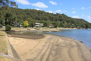
Woronora is a suburb in southern Sydney, in the state of New South Wales, Australia. Woronora is located 27 kilometres south of the Sydney central business district, in the local government area of the Sutherland Shire. Woronora Heights is a separate suburb, to the south-west.

Woronora Heights is a suburb in southern Sydney, in the state of New South Wales, Australia. Woronora Heights is located 29 kilometres south of the Sydney central business district, in the local government area of the Sutherland Shire. Woronora is a separate suburb, to the north. Most streets in Woronora Heights are named after birds.

The Hacking River is a watercourse that is located in the Southern Sydney region of New South Wales in Australia. For thousands of years traditional owners called the river Deeban, however the colonial settlers renamed the river after Henry Hacking, a British seaman who killed Pemulwuy and was a pilot at Port Jackson in colonial New South Wales.

Bonnet Bay is a suburb in southern Sydney, in the state of New South Wales, Australia that is located 29 kilometres (18 mi) south of the Sydney central business district in the local government area of the Sutherland Shire. Its postcode is 2226, which it shares with neighbouring Jannali and Como. Bonnet Bay is located on the eastern bank of the Woronora River, which flows north into the Georges River.

The Woronora Dam is a heritage-listed concrete gravity dam with an uncontrolled serpentine spillway across the Woronora River, located south of Greater Metropolitan Sydney, in the suburb of Woronora Dam, Sutherland Shire, New South Wales, Australia. The principal purpose of the dam is for potable water supply for Sydney's southern suburbs and the northern suburbs of the Illawarra region. The impounded 71,790-megalitre reservoir is also called Woronora Dam and is sometimes incorrectly called Lake Woronora. The dam was designed by G. E. Haskins, Chief Engineer and the Metropolitan Water, Sewerage and Drainage Board of NSW (MWS&DB) and built from 1927 to 1941 by the MWS&DB. The property is owned by the Sydney Catchment Authority, an agency of the Government of New South Wales. It was added to the New South Wales State Heritage Register on 18 November 1999.

The Woronora River is a perennial river of the Sydney Basin, located in the Sutherland Shire local government area of Greater Metropolitan Sydney, approximately 22 kilometres (14 mi) south of the Sydney central business district, in New South Wales, Australia.

The geography of Sydney is characterised by its coastal location on a basin bordered by the Pacific Ocean to the east, the Blue Mountains to the west, the Hawkesbury River to the north and the Woronora Plateau to the south. Sydney lies on a submergent coastline on the east coast of New South Wales, where the ocean level has risen to flood deep river valleys (rias) carved in the Sydney sandstone. Port Jackson, better known as Sydney Harbour, is one such ria.

Helensburgh is a small town, located 45 kilometres (28 mi) south of Sydney and 35 kilometres (22 mi) north of Wollongong and north and above the Illawarra escarpment and region. Helensburgh is in the Wollongong City Council local government area. It is surrounded by bushland reserves adjacent to the southern end of the Royal National Park and Garawarra State Conservation Area and the Woronora reservoir water catchment is to its west.

The Cumberland Plain, also known as Cumberland Basin, is a relatively flat region lying to the west of Sydney CBD in New South Wales, Australia. An IBRA biogeographic region, Cumberland Basin is the preferred physiographic and geological term for the low-lying plain of the Permian-Triassic Sydney Basin found between Sydney and the Blue Mountains, and it is a structural sub-basin of the Sydney Basin.

The 1998 Sydney water crisis involved the suspected contamination of the water supply system of Greater Metropolitan Sydney by the microscopic pathogens Cryptosporidium and Giardia between July and September 1998.

The Woronora River Bridge, also known as Woronora Bridge, is a four-lane road bridge that carries River Road across the Woronora River at Woronora, in Southern Sydney, New South Wales, Australia. The bridge, at the time of its completion in 2001, was the largest incrementally launched bridge in the Southern Hemisphere with horizontal and vertical curves.

The Dharawal National Park is a protected national park that is located in the Illawarra region of New South Wales, in eastern Australia. The 6,508-hectare (16,080-acre) national park is situated between the Illawarra Range and the Georges River and is approximately 45 kilometres (28 mi) south west of Sydney. There are three entry points to the park: from the east through Darkes Forest; from the north through Wedderburn; and from the south through Appin.

The Hornsby Plateau is a dissected sandstone plateau lying to the north of Sydney Harbour that rises 200 metres. The plateau is a part of the larger Sydney Basin structure.

The ecology of Sydney, located in the state of New South Wales, Australia, is diverse for its size, where it would mainly feature biomes such as grassy woodlands or savannas and some sclerophyll forests, with some pockets of mallee shrublands, riparian forests, heathlands, and wetlands, in addition to small temperate and subtropical rainforest fragments.
The Metropolitan Colliery is a coal mine located near Helensburgh, New South Wales owned by Peabody Energy. It was opened by in 1887 by the Cumberland Coal & Iron Mining Company. In 1965, the mine was purchased by Australian Iron & Steel. A proposed sale to South32 in 2016 was abandoned after the Australian Competition & Consumer Commission refused to approve it.
