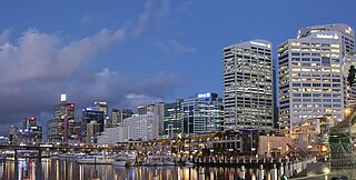
Darling Harbour is a harbour adjacent to the city centre of Sydney, New South Wales, Australia that is made up of a large recreational and pedestrian precinct that is situated on western outskirts of the Sydney central business district.

The Sydney Harbour National Park is an Australian national park comprising parts of Port Jackson, Sydney and its foreshores and various islands. The 392-hectare (970-acre) national park lies in New South Wales and was created progressively, from 1975.

Port Jackson, consisting of the waters of Sydney Harbour, Middle Harbour, North Harbour and the Lane Cove and Parramatta Rivers, is the ria or natural harbour of Sydney, Australia. The harbour is an inlet of the Tasman Sea. It is the location of the Sydney Opera House and Sydney Harbour Bridge. The location of the first European settlement and colony on the Australian mainland, Port Jackson has continued to play a key role in the history and development of Sydney.

Rose Bay is a harbourside, eastern suburb of Sydney, in the state of New South Wales, Australia. Rose Bay is located seven kilometres east of the Sydney central business district, in the local government areas of Waverley Council and Municipality of Woollahra.

Chinatown is an urban enclave situated in the southern part of the Sydney Central Business District, in New South Wales, Australia. It is located and comprises the majority of the Haymarket suburb, between Central station and Darling Harbour. It is part of the local government area of the City of Sydney and is Australia's largest Chinatown.

Woolloomooloo is a harbourside, inner-city eastern suburb of Sydney, New South Wales, Australia. Woolloomooloo is 1.5 kilometres east of the Sydney central business district, in the local government area of the City of Sydney. It is in a low-lying, former docklands area at the head of Woolloomooloo Bay, on Sydney Harbour. The Domain sits to the west, the locality of East Sydney is near the south-west corner of the suburb and the locality of Kings Cross is near the south-east corner. Potts Point is immediately to the east.

Milsons Point is a suburb on the lower North Shore of Sydney, in the state of New South Wales, Australia. The suburb is located 3 kilometres north of the Sydney central business district in the local government area of North Sydney Council.

Lavender Bay is a harbourside suburb on the lower North Shore of Sydney, New South Wales, Australia. Lavender Bay is located 3 kilometres north of the Sydney central business district, in the local government area of North Sydney Council.

Pyrmont is an inner-city suburb of Sydney, in the state of New South Wales, Australia 2 kilometres south-west of the Sydney central business district in the local government area of the City of Sydney. It is also part of the Darling Harbour region. As of 2011, it is Australia's most densely populated suburb.

Double Bay is a harbourside eastern suburb of Sydney, in the state of New South Wales, Australia 4 kilometres east of the Sydney central business district. It is the administrative centre of the local government area of the Municipality of Woollahra.
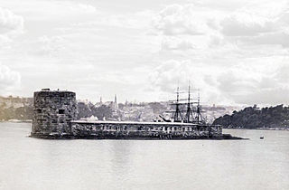
Fort Denison, part of the Sydney Harbour National Park, is a protected national park that is a heritage-listed former penal site and defensive facility occupying a small island located north-east of the Royal Botanic Gardens and approximately 1 kilometre (0.62 mi) east of the Opera House in Sydney Harbour, New South Wales, Australia. The island was formerly known in its indigenous name of Mat-te-wan-ye, and as Pinchgut Island.
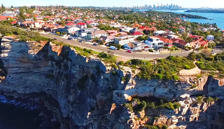
Vaucluse is an eastern suburb of Sydney, in the state of New South Wales, Australia. It is located 8 kilometres (5 mi) north-east of the Sydney central business district, in the local government areas of Waverley Council and the Municipality of Woollahra.

The Division of Sydney is an Australian electoral division in the state of New South Wales.

Shark Island is an island in Sydney Harbour, in New South Wales, Australia. The island is 1.5 hectares in area, measuring some 250 metres by 100 metres, and lies off the Sydney suburbs of Point Piper, Rose Bay and Vaucluse, in the eastern section of the harbour between the Harbour Bridge and the harbour entrance. The island was known by the local Aboriginal people as Boambilly, and the current name comes from its shape, which is claimed to resemble a shark.

The Sydney Heads are a series of headlands that form the 2 km (1.2 mi) wide entrance to Sydney Harbour in Sydney, New South Wales, Australia. North Head and Quarantine Head are to the north; South Head and Dunbar Head are to the south; and Middle Head, Georges Head, and Chowder Head are to the west and within the harbour. The Heads are contained within the Sydney Harbour National Park.

Bradleys Head is a headland protruding from the north shore of Sydney Harbour, within the metropolitan area of Sydney, New South Wales, Australia. It is named after the First Fleet naval officer William Bradley. The original Aboriginal inhabitants belonged to the Borogegal clan of the Eora nation, and was known as Borogegy, Booraghee, Booragy or Burrogy. Also on the headland is an active lighthouse, Bradleys Head Light, constructed in 1905.

The geography of Sydney is characterised by its coastal location on a basin bordered by the Pacific Ocean to the east, the Blue Mountains to the west, the Hawkesbury River to the north and the Woronora Plateau to the south. Sydney lies on a submergent coastline on the east coast of New South Wales, where the ocean level has risen to flood deep river valleys (rias) carved in the Sydney sandstone. Port Jackson, better known as Sydney Harbour, is one such ria.

Glebe Island was a major port facility in Sydney Harbour and, in association with the adjacent White Bay facility, was the primary receiving venue for imported cars and dry bulk goods in the region until 2008. It is surrounded by White, Johnstons, and Rozelle Bays. Whilst retaining its original title as an "island", it has long been infilled to the shoreline of the suburb of Rozelle and connected by the Glebe Island Bridge to Pyrmont.

Mosman is a suburb on the Lower North Shore of Sydney, in the state of New South Wales, Australia. Mosman is located 8 kilometres north-east of the Sydney central business district and is the administrative centre for the local government area of the Municipality of Mosman.

The National Herbarium of New South Wales was established in 1853. The Herbarium has a collection of more than 1.4 million plant specimens, making it the second largest collection of pressed, dried plant specimens in Australia, including scientific and historically significant collections and samples of Australian flora gathered by Joseph Banks and Daniel Solander during the voyage of HMS Endeavour in 1770.


