Darling Point, New South Wales

Last updated

Darling Point
Sydney,  New South Wales
(1)Darling Point homes.jpg
Darling Point
Darling Point, New South Wales
Population3,977 (SAL 2021) [1]
Established1833
Postcode(s) 2027
Area0.67 km2 (0.3 sq mi)
Location4 km (2 mi) E of Sydney CBD
LGA(s) Woollahra Council
State electorate(s) Vaucluse
Federal division(s) Wentworth
Suburbs around Darling Point:
Port Jackson
Elizabeth Bay Darling Point Double Bay
Rushcutters Bay Edgecliff Woollahra
Cruising Yacht Club of Australia Darling Point Cruising Yacht Club of Australia.JPG
Cruising Yacht Club of Australia

Darling Point is a harbourside eastern suburb of Sydney, Australia. It is 4 kilometres east of the Sydney central business district and is part of the local government area of Woollahra Council. [2]

Contents

Darling Point is bounded by Sydney Harbour to the north, Double Bay to the east, Edgecliff to the south and Rushcutters Bay to the west. Darling Point, renowned for its desirable and expensive real estate, is mostly residential and regarded as one of the most exclusive and prestigious suburbs in Australia.

History

What is now the Darling Point area was originally known as Eurambi, Yarranabbi, Yarrandabbi and Yaranabe by the local Aboriginal people. It was named Darling Point in recognition of Elizabeth Darling, the wife of New South Wales Governor Ralph Darling. [3]

During the Sydney 2000 Olympics, Darling Point hosted the sailing events.

Transport

Darling Point Road follows the ridge of the headland that is Darling Point. Mona Road and Greenoaks Avenue act as two other main access roads to the suburb. New Beach Road runs between the western boundary of the suburb and Rushcutters Bay Park. The 327 bus service used to go through Darling Point but it has been reduced to a lesser route, now called 328. Darling Point ferry wharf provides access to Double Bay ferry services. Darling Point is also serviced by the nearby Edgecliff railway station.

Parks

McKell Park was originally the site of the now-demolished Canonbury House, but is now a public park. Situated at the northern end of Darling Point Road, it has panoramic views of Sydney Harbour and is a popular location for picnics and weddings. It also provides access to Darling Point's ferry stop.

"The Drill Hall" forms part of the Sir David Martin Reserve and was previously part of the Royal Australian Navy base, HMAS Rushcutter. The Drill hall is one of the oldest-surviving Australian military buildings and was originally located on Bennelong Point, now the location of the Sydney Opera House.

Places of worship

Saint Mark's Anglican Church in Darling Point Road was designed by Edmund Blacket in 1852 and is now a popular wedding venue. It has hosted weddings such as Elton John's first wedding and the fictional wedding in the film Muriel's Wedding . The rectory, also designed by Blacket, is listed on the local government heritage register. [4] [5] [6]

Landmarks

Craigend

Situated close to McKell Park, Craigend is a mansion constructed in the Moorish and Art Deco styles in 1935, including a pair of doors from an ancient mosque in Zanzibar and a traditional Japanese garden. In 1948, the property was acquired by the US government as the official residence of the Consul-General. It has since returned to the private sector. In 1975, it served as the shooting location for the villain's lair in the Hong Kong / Australian co-production The Man from Hong Kong . The house is heritage-listed. [7]

Carthona

Built in 1841 for the Surveyor-General Sir Thomas Mitchell, Carthona is a harborside sandstone mansion located at the end of Carthona Avenue. With its panoramic water views across Double Bay, to Point Piper, and north toward Manly, it is considered[ by whom? ] one of Sydney's most-valuable properties. It is currently held by descendants of Philip Bushell, the tea merchant, who died at the home in 1954. It is heritage-listed. [8]

Glanworth

In 1966 James Fairfax paid $240,000 to purchase Glanworth in Lindsay Avenue. The house designed by Joseph Alexander Kethel had been built in 1916 for Peter Britz, an American from Buffalo, New York, on a lot carved from the Lindsay Estate and was originally known as Youbri. It is a rare example of an American plantation-style residence with deep verandas and oversized antebellum concrete columns and piers. Faifax owned the house for 28 years and sold it for $8.5 million to a Singaporean hotel magnate who sold it to Kerry Stokes for $9.5 million in 1998. [9]

Heritage listings

Cloncorrick, designed by John Horbury Hunt 1 Cloncorrick.jpg
Cloncorrick, designed by John Horbury Hunt
Swifts Swifts Side View.jpg
Swifts

Darling Point has a number of heritage-listed sites, including:

In additional, the following buildings are on the (now defunct) Register of the National Estate. [14]

Clubs

The Cruising Yacht Club of Australia, Australia's premier yacht club, is situated near Rushcutters Bay Park and runs the annual Sydney to Hobart Yacht Race.

Population

Demographics

St Marks Anglican Church 1 St Marks Church.jpg
St Marks Anglican Church

At the 2016 census, there were 4,190 residents in Darling Point. The most common ancestries in Darling Point were English (24.1%), Australian (15.1%), Irish (9.7%), Scottish 7.4% and Chinese 3.3%. 54.2% of residents were born in Australia. The most common countries of birth were England 5.3%, New Zealand 3.4% and South Africa 3.2%. 72.6% of people spoke only English at home. The most common responses for religion were No Religion 27.2%, Catholic 18.3% and Anglican 16.5%. The median weekly household income in Darling Point was $2,966, slightly more than double the national median of $1,438. Darling Point is a suburb with high density housing, with 87.3% of occupied private dwellings being flats, units or apartments, 6.3% being separate houses and 5.5% being semi-detached. [15]

At the 2021 census, the population of Darling Point was 3,977. [16]

According to analysis of Australian Taxation Office return records by the Queensland University of Technology, Darling Point donates more money to charities than any other area in Australia. This is primarily as the residents of the area are generally wealthy and make good use of the tax reductions that come with donations. [17]

Notable residents

Related Research Articles

<span class="mw-page-title-main">Darlinghurst, New South Wales</span> Suburb of Sydney, New South Wales, Australia

Darlinghurst is an inner-city, eastern suburb of Sydney, New South Wales, Australia. Darlinghurst is located immediately east of the Sydney central business district (CBD) and Hyde Park, within the local government area of the City of Sydney. It is often colloquially referred to as "Darlo".

<span class="mw-page-title-main">Glebe, New South Wales</span> Suburb of Sydney, New South Wales, Australia

Glebe is an inner-western suburb of Sydney. Glebe is located 3 kilometres (1.9 mi) southwest of the Sydney central business district and is part of the local government area of the City of Sydney, in the Inner West region.

<span class="mw-page-title-main">Potts Point, New South Wales</span> Suburb of Sydney, New South Wales, Australia

Potts Point is a small and densely populated suburb in inner-east Sydney, New South Wales, Australia. Potts Point is located 2 kilometres (1.2 mi) east of the Sydney central business district and is part of the local government area of the City of Sydney.

<span class="mw-page-title-main">Pyrmont, New South Wales</span> Suburb of Sydney, New South Wales, Australia

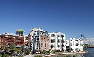
Pyrmont is an inner-city suburb of Sydney, in the state of New South Wales, Australia 2 kilometres south-west of the Sydney central business district in the local government area of the City of Sydney. It is also part of the Darling Harbour region. As of 2011, it is Australia's most densely populated suburb.

<span class="mw-page-title-main">Double Bay, New South Wales</span> Suburb of Sydney, New South Wales, Australia

Double Bay is a harbourside eastern suburb of Sydney, in the state of New South Wales, Australia 4 kilometres east of the Sydney central business district. It is the administrative centre of the local government area of the Municipality of Woollahra.

<span class="mw-page-title-main">Watsons Bay, New South Wales</span> Suburb of Sydney, New South Wales, Australia

Watsons Bay is a harbourside, eastern suburb of Sydney, in the state of New South Wales, Australia. Watsons Bay is located 11 km north-east of the Sydney central business district, in the local government area of the Municipality of Woollahra.

<span class="mw-page-title-main">Thomas Sutcliffe Mort</span> Australian industrialist (1816 – 1878)

Thomas Sutcliffe Mort was an Australian industrialist who improved the refrigeration of meat. He was renowned for speculation in the local pastoral industry as well as industrial activities such as his Ice-Works in Sydney's Darling Harbour and dry dock and engineering works at Balmain.

<span class="mw-page-title-main">Edgecliff, New South Wales</span> Suburb of Sydney, New South Wales, Australia

Edgecliff is a small suburb in the Eastern Suburbs of Sydney, in the state of New South Wales, Australia. Edgecliff is located 4 kilometres east of the Sydney central business district, in the local government area of the Municipality of Woollahra. The postcode is 2027.

<span class="mw-page-title-main">Mosman Council</span> Local government area in New South Wales, Australia

Mosman Council is a local government area on the Lower North Shore of Sydney, New South Wales, Australia.

<span class="mw-page-title-main">City of Randwick</span> Local government area in New South Wales, Australia

The City of Randwick is a local government area in the Eastern Suburbs of Sydney, New South Wales, Australia located south-east of the CBD. Established in 1859, Randwick is the second-oldest local government area in New South Wales, after the City of Sydney. It comprises an area of 36 square kilometres (14 sq mi) and as at the 2016 census had a population of 140,660.

<span class="mw-page-title-main">Municipality of Woollahra</span> Local government area in New South Wales, Australia

Woollahra Municipal Council is a local government area in the eastern suburbs of Sydney, in the state of New South Wales, Australia. Woollahra is bounded by Sydney Harbour in the north, Waverley Council in the east, Randwick City in the south and the City of Sydney in the west.

<span class="mw-page-title-main">Rushcutters Bay, New South Wales</span> Suburb of Sydney, New South Wales, Australia

Rushcutters Bay is a harbourside inner-east suburb of Sydney, in the state of New South Wales, Australia 3 kilometres east of the Sydney central business district, in the local government area of the City of Sydney.

<span class="mw-page-title-main">Elizabeth Bay, New South Wales</span> Suburb of Sydney, New South Wales, Australia

Elizabeth Bay is a harbourside inner city eastern suburb of Sydney, in the state of New South Wales, Australia. Elizabeth Bay is located three kilometres east of the Sydney central business district and is part of the local government area of the City of Sydney.

<span class="mw-page-title-main">Dawes Point, New South Wales</span> Suburb of Sydney, New South Wales, Australia

Dawes Point is a suburb of the City of Sydney, in the state of New South Wales, Australia. Dawes Point is located on the north-western edge of the Sydney central business district, at the southern end of Sydney Harbour Bridge, adjacent to The Rocks. At times Dawes Point has been considered to be part of The Rocks, or known as West Rocks, part of Millers Point, or part of it known as Walsh Bay.

<span class="mw-page-title-main">John Horbury Hunt</span> Australian architect

John Horbury Hunt, often referred to as Horbury Hunt, was a Canadian-born Australian architect who worked in Sydney and rural New South Wales from 1863.

<span class="mw-page-title-main">Mosman, New South Wales</span> Suburb of Sydney, New South Wales, Australia

Mosman is a suburb on the Lower North Shore region of Sydney, in the state of New South Wales, Australia. Mosman is located 8 kilometres north-east of the Sydney central business district and is the administrative centre for the local government area of the Municipality of Mosman.

<span class="mw-page-title-main">Bishopscourt, Darling Point</span>

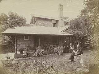
Bishopscourt, Darling Point is a heritage-listed residence and former archbishop's residence at 11A Greenoaks Avenue, Darling Point, Municipality of Woollahra, New South Wales, Australia. It was designed by J. F. Hilly (1846), Edmund Blacket (1859) and Leslie Wilkinson (1935) and built from 1846 to 1849 by Thomas Woolley (1841); Thomas Sutcliffe Mort. It is also known as Bishopscourt and Greenoaks. Up until December 2015, the property was owned by the Anglican Diocese of Sydney; and is now privately owned. The property was added to the New South Wales State Heritage Register on 2 April 1999.

<span class="mw-page-title-main">St Mark's Church, Darling Point</span> Church in New South Wales, Australia

St Mark's Church is an active Anglican church in Darling Point, a suburb of Sydney, New South Wales, Australia. It is part of a significant local heritage group that includes the church, rectory, and adjacent cottage. The group forms part of a large collection of important to late 19th century buildings of considerable townscape, historic and cultural significance, including the former St Mark's Crescent School, St Mark's Cottage and Bishopscourt, formerly Greenoaks.

<span class="mw-page-title-main">18-20a Munn Street, Millers Point</span> Historic site in New South Wales, Australia

18-20a Munn Street is a heritage-listed row of terrace houses located at 18, 18a, 20, 20a Munn Street, in the inner city Sydney suburb of Millers Point in the City of Sydney local government area of New South Wales, Australia. It was added to the New South Wales State Heritage Register on 2 April 1999.

References

  1. Australian Bureau of Statistics (28 June 2022). "Darling Point (Suburb and Locality)". Australian Census 2021 QuickStats. Retrieved 28 June 2022.  OOjs UI icon edit-ltr-progressive.svg
  2. Gregory's Sydney Street Directory, Gregory's Publishing Company, 2007
  3. The Book of Sydney Suburbs, Compiled by Frances Pollen, Angus & Robertson Publishers, 1990, Published in Australia ISBN   0-207-14495-8, page 79
  4. "St Marks Anglican church". New South Wales Heritage Database. Office of Environment & Heritage . Retrieved 19 March 2018.
  5. "Rectory of St Marks church". New South Wales Heritage Database. Office of Environment & Heritage . Retrieved 19 March 2018.
  6. "St Marks Cottage – building, sandstone retaining walls". New South Wales Heritage Database. Office of Environment & Heritage . Retrieved 19 March 2018.
  7. Craigend - house State Heritage Website
  8. The Heritage of Australia, Macmillan Company, 1981, p.2/132
  9. Sydney's changing waterfront Retrieved 13 April 2023.
  10. "Lindesay". New South Wales State Heritage Register . Department of Planning and Environment. H00686. Retrieved 18 May 2018. CC-BY icon.svg Text is licensed by State of New South Wales (Department of Planning and Environment) under CC-BY 4.0 licence .
  11. "Swifts". New South Wales State Heritage Register . Department of Planning and Environment. H00146. Retrieved 18 May 2018. CC-BY icon.svg Text is licensed by State of New South Wales (Department of Planning and Environment) under CC-BY 4.0 licence .
  12. "Babworth House". New South Wales State Heritage Register . Department of Planning and Environment. H01300. Retrieved 18 May 2018. CC-BY icon.svg Text is licensed by State of New South Wales (Department of Planning and Environment) under CC-BY 4.0 licence .
  13. "Bishopscourt". New South Wales State Heritage Register . Department of Planning and Environment. H00362. Retrieved 18 May 2018. CC-BY icon.svg Text is licensed by State of New South Wales (Department of Planning and Environment) under CC-BY 4.0 licence .
  14. The Heritage of Australia, Macmillan Company, 1981, pp. 2, 132–133
  15. Australian Bureau of Statistics (27 June 2017). "Darling Point (State Suburb)". 2016 Census QuickStats. Retrieved 2 July 2017. OOjs UI icon edit-ltr-progressive.svg
  16. "2021 Darling Point, Census All persons QuickStats". Australian Bureau of Statistics. Retrieved 18 August 2022.
  17. Australia's Tax Deductible Donations on the Rise, Pro Bono Australia, 3 September 2013, archived from the original on 30 January 2014
  18. 'Zenobia' (21 February 1907). "Sydney Social". Melbourne Punch , p. 35. Retrieved 9 October 2019.

Coordinates: 33°52′13″S151°14′15″E / 33.87021°S 151.23746°E / -33.87021; 151.23746