The Hume Highway, inclusive of the sections now known as the Hume Freeway and Hume Motorway, is one of Australia's major inter-city national highways, running for 840 kilometres (520 mi) between Melbourne in the southwest and Sydney in the northeast. Upgrading of the route from Sydney's outskirts to Melbourne's outskirts to dual carriageway was completed on 7 August 2013.

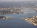
The Georges River, also known as Tucoerah River, is an intermediate tide-dominated drowned valley estuary, located to the south and west of Sydney, New South Wales, Australia.

Gladesville Bridge is a heritage-listed concrete arch road bridge that carries Victoria Road over the Parramatta River, linking the Sydney suburbs of Huntleys Point and Drummoyne, in the local government areas of Canada Bay and Hunter's Hill, in New South Wales, Australia. Despite its name, the bridge is not located in Gladesville.

The Princes Highway is a major road in Australia, extending from Sydney to Adelaide via the coast through the states of New South Wales, Victoria and South Australia. It has a length of 1,941 kilometres (1,206 mi) or 1,898 kilometres (1,179 mi) via the former alignments of the highway, although these routes are slower and connections to the bypassed sections of the original route are poor in many cases.

The Princes Motorway is a 55-kilometre (34 mi) predominately dual carriage untolled motorway that links Sydney to Wollongong and further south through the Illawarra region to Albion Park Rail. Part of the Australian Highway 1 network, the motorway is designated with the route number M1.

The Roads & Traffic Authority (RTA) was an agency of the New South Wales Government responsible for major road infrastructure, licensing of drivers, and registration of motor vehicles. The RTA directly managed State roads and provided funding to local councils for regional and local roads. In addition, with assistance from the Federal Government, the RTA also managed the NSW national highway system. The agency was abolished in 2011 and replaced by New South Wales Roads and Maritime Services.

The Pacific Motorway is a motorway in Australia between Brisbane, Queensland, and Brunswick Heads, New South Wales, through the New South Wales–Queensland border at Tweed Heads.
Sans Souci is a southern Sydney suburb in the state of New South Wales, Australia. Sans Souci is 17 kilometres south of the Sydney central business district and lies across the local government areas of the Bayside Council and the Georges River Council. It is part of the St George area.

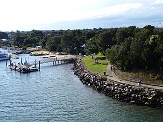
Taren Point is a suburb, in southern Sydney, in the state of New South Wales, Australia 20 kilometres south of the Sydney central business district in the local government area of the Sutherland Shire.

The Warringah Freeway is a 3-kilometre (1.9 mi) divided freeway located in Sydney, New South Wales, Australia. The freeway forms part of the M1, the Sydney Orbital Network, and the Highway 1 network. The primary function of the freeway is to provide an alternative high-grade route from the Sydney Harbour Tunnel and the Bradfield Highway at Milsons Point to the A8 and the Gore Hill Freeway. The freeway reduces traffic demands on the Pacific Highway throughout Sydney's lower north shore, bypassing North Sydney and Crows Nest. Completed in a series of stages between June 1968 and August 1992, the Warringah Freeway provides a vital link to access most of the suburbs in Sydney and is also a major route to the north, south, east and west of the central business district.
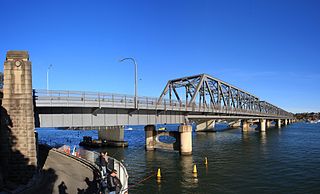
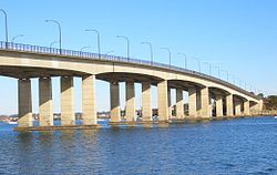
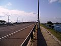
Tom Uglys Bridge are two road bridges, completed in 1929 and 1987, that carry the Princes Highway (A36) across the Georges River in southern Sydney, in the state of New South Wales, Australia. The bridges link the St George area at Blakehurst to the Sutherland Shire at Sylvania. Tom Uglys Bridge is one of six major road crossings of Georges River.

Alfords Point Bridge is a twin 445-metre-long (1,460 ft) concrete and steel box girder road bridge that carries Alford Point Road as state route A6 across the lower Georges River between Padstow Heights in the City of Bankstown and Alfords Point in the Sutherland Shire in Sydney, New South Wales, Australia.

Taren Point Road is a major road found in Taren Point and Caringbah, New South Wales, Australia.

The Mooney Mooney Bridge, officially the Mooney Mooney Creek Bridge, and popularly known as The NSW Big Dipper Bridge, is a twin cantilever bridge that carries the Pacific Motorway (M1) across Mooney Mooney Creek, located near Mooney Mooney in the Brisbane Water National Park on the Central Coast of New South Wales, Australia. The concrete box girder bridge was opened on 14 December 1986 by the Prime Minister of Australia, Bob Hawke, and is owned and maintained by Transport for NSW, an agency of the Government of New South Wales.

General Holmes Drive is a 5-kilometre (3.1 mi) major divided road located in Sydney, New South Wales, Australia. The road forms part of the M1, the A1, the Sydney Orbital Network, and the Australian Highway 1 network. Initially built in 1919 as a two-lane road and duplicated in 1951, the road partially circumnavigates Sydney Airport with its north-eastern terminus in Mascot, heading west and then south and then south-west, with its south-western terminus with The Grand Parade in Brighton-Le-Sands.

The Henry Lawson Drive is a 20-kilometre (12 mi) major urban sealed road, located in Sydney, New South Wales, Australia. The road's northwestern terminus is located at the Meccano Set in Villawood, with its southeastern terminus located at the road's junction with Forest Road, located in Peakhurst. The road is named in honour of Henry Lawson, one of Australia's foremost poets.

The Peats Ferry Bridge is a steel truss bridge that carries the Old Pacific Highway (B83) across the Hawkesbury River, between Kangaroo Point and Mooney Mooney Point, located 40 kilometres (25 mi) north of Sydney in New South Wales, Australia. The bridge carries the Hornsby to Kariong section of highway, while the adjacent Brooklyn Bridge carries the Pacific Motorway (M1).
The Brooklyn Bridge is a concrete girder bridge that carries the Pacific Motorway (M1) across the Hawkesbury River between Kangaroo Point to Mooney Mooney Point, located 35 kilometres (22 mi) north of Sydney in New South Wales, Australia. The bridge comprises a dual carriageway with three lanes in each direction of motorway grade-separated conditions.
Milperra Bridge is a road bridge that carries Newbridge Road across the Georges River, located between Bankstown and Liverpool, in south-western Sydney, New South Wales, Australia. The bridge is located adjacent to Henry Lawson Drive and the Bankstown Airport; and Newbridge Road serves as a continuation of Canterbury and Milperra Roads.

Raymond John Lloyd Wedgwood was an Australian engineer who served as the Chief Bridge Engineer of the NSW Department of Main Roads (DMR) and the Roads and Traffic Authority of NSW (RTA). He designed and supervised the construction of many major bridges across New South Wales and led the design team for the cable stayed Anzac Bridge in Sydney. He also played a pivotal role in the development of a common code of bridge design practice used by all Australian state road authorities.