
Gladesville Bridge is a heritage-listed concrete arch road bridge that carries Victoria Road over the Parramatta River, linking the Sydney suburbs of Huntleys Point and Drummoyne, in the local government areas of Canada Bay and Hunter's Hill, in New South Wales, Australia. Despite its name, the bridge is not in Gladesville.
The Parramatta River is an intermediate tide-dominated, drowned valley estuary located in Sydney, New South Wales, Australia. With an average depth of 5.1 metres (17 ft), the Parramatta River is the main tributary of Sydney Harbour, a branch of Port Jackson. Secondary tributaries include the smaller Lane Cove and Duck rivers.

Hunters Hill is a suburb of Northern Sydney, in the state of New South Wales, Australia. Hunters Hill is located 9 kilometres (5.6 mi) north-west of the Sydney central business district and is the administrative centre for the local government area of the Municipality of Hunter's Hill.

Drummoyne is a suburb in the Inner West of Sydney, in the state of New South Wales, Australia. Drummoyne is six kilometres west of the Sydney central business district and is the administrative centre for the local government area of the City of Canada Bay.

M1 Pacific Motorway is a 127-kilometre motorway linking Sydney to Newcastle via the Central Coast and Hunter regions of New South Wales. Formerly known but still commonly referred to by both the public and the government as the F3 Freeway, Sydney–Newcastle Freeway, and Sydney–Newcastle Expressway, it is part of the AusLink road corridor between Sydney and Brisbane.

Bradfield Highway is a 2.1-kilometre (1.3 mi) highway that crosses the Sydney Harbour Bridge in Sydney, New South Wales and is one of the shortest highways in Australia. It opened along with the bridge itself on 19 March 1932 and was named in honour of John Bradfield, the engineer who designed and helped construct it.

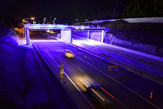
Warringah Freeway is a 3.5-kilometre (2.2 mi) divided freeway in Sydney, New South Wales, Australia that is part of the Sydney Orbital Network. The primary function of the freeway is to provide an alternative high-grade route from the Sydney Harbour Tunnel and Bradfield Highway at Milsons Point to the A8 and Gore Hill Freeway. The freeway reduces traffic demands on Pacific Highway throughout Sydney's Lower North Shore, bypassing North Sydney and Crows Nest, and provides a vital link to access most of the suburbs in Sydney and is also a major route to the north, south, east and west of the central business district.

The Iron Cove Bridge is a heritage-listed road bridge that carries Victoria Road (A40) across Iron Cove, between the Sydney suburbs of Drummoyne and Rozelle. Iron Cove is an arm of Sydney Harbour.

The Tarban Creek Bridge is a prestressed concrete arch bridge that carries the Burns Bay Road across the Tarban Creek, located west of the Sydney central business district in New South Wales, Australia. The bridge is situated between the Gladesville Bridge and the Fig Tree Bridge, being immediately to the north of Gladesville Bridge. The bridge connects the suburbs of Hunters Hill and Huntleys Point. In addition to the four-lane carriage, the bridge carries a grade-separated shared pedestrian footpath and cycleway.
M2 Hills Motorway is a 19.3-kilometre (12.0 mi) tolled urban motorway in Sydney, New South Wales that is part of the Sydney Orbital Network and the National Highway west of Pennant Hills Road. Owned by toll road operator Transurban, it forms majority of Sydney's M2 route, with the Lane Cove Tunnel constituting the rest of the M2 route.

Western Distributor is a 4.3-kilometre-long (2.7 mi) grade-separated motorway that is primarily elevated for the majority of its route on the western fringe of the Sydney central business district. It links the southern end of Bradfield Highway at the Sydney Harbour Bridge to Victoria Road in Rozelle, at its western terminus near White Bay. It is a constituent part of the A4 route.
Sydney Bypass refers to a number of roads, existing and proposed, that motorists can use to avoid the congested approaches to the Sydney central business district (CBD). The main bypasses are:
The North Western Expressway and the Lane Cove Valley Expressway was a planned but later cancelled freeway route in Sydney, New South Wales, Australia, intended to link the Sydney central business district to its north-western suburbs, and ultimately the Sydney–Newcastle Freeway to Newcastle. The entirety of the Sydney to Newcastle route was to be known as the F3 Freeway, a name that remains as a common name of the Sydney–Newcastle Freeway.

Fullers Bridge, officially called the Fullers Creek Bridge, is a road bridge that carries Delhi Road to Millwood Avenue across the Lane Cove River, in Chatswood West, Sydney, New South Wales, Australia. The concrete beam bridge is located 9 kilometres (5.6 mi) northwest of the Sydney central business district and connects Chatswood to North Ryde as part of the A38.

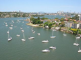
Huntleys Cove is a suburb on the Lower North Shore of Sydney, in the state of New South Wales, Australia. Huntleys Cove is located 9 kilometres north-west of the Sydney central business district, in the local government area of the Municipality of Hunter's Hill. Huntleys Cove sits on the peninsula between Tarban Creek and the Parramatta River.

Victoria Road is a major road in Sydney, New South Wales, Australia, connecting Parramatta with Rozelle and is currently one of the longest roads in Sydney. The road passes over two major bridges: the Iron Cove Bridge over Iron Cove, and the Gladesville Bridge over the Parramatta River.
Tarban Creek, a northern tributary of the Parramatta River, is a creek west of Sydney Harbour, in Sydney, New South Wales, Australia.
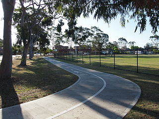
Bike paths in Sydney, New South Wales, Australia, vary widely, with the majority either shared cycle and pedestrian paths or on road paths, and a small number of separated cycleways. In 2009 the Sydney Morning Herald reported that "Sydney's cycleways are not so much an organised network as a fragmented collection of winding paths and half-finished ideas. Most were built or designed when cycling was viewed as a pleasant pastime rather than a practical form of travel and are now poorly suited to commuting."


